汤峰2,
张贵军1,,,
张蓬涛1,
王力3
1.河北农业大学国土资源学院/河北省农田生态环境重点实验室 保定 071001
2.中国地质大学(北京)土地科学技术学院 北京 100083
3.中国科学院空天信息创新研究院遥感科学国家重点实验室 北京 100101
基金项目: 国家自然科学基金项目41871347
国家重点研发计划项目2016YFC0502501
河北省社会科学基金项目HB19YJ020
详细信息
作者简介:刘婧, 主要研究方向为土地评价与可持续利用。E-mail: liujingahcz@163.com
通讯作者:张贵军, 主要研究方向为土地评价与可持续利用。E-mail: 2569401081@qq.com
中图分类号:F301.2计量
文章访问数:105
HTML全文浏览量:35
PDF下载量:13
被引次数:0
出版历程
收稿日期:2020-09-09
录用日期:2021-03-03
刊出日期:2021-07-01
Timing sequence of permanent basic farmland reserve area delineation based on TOPSIS and the matrix grouping method at the county level
LIU Jing1,,TANG Feng2,
ZHANG Guijun1,,,
ZHANG Pengtao1,
WANG Li3
1. College of Land and Resources, Hebei Agricultural University/Key Laboratory for Farmland Eco-Environment of Hebei Province, Baoding 071001, China
2. College of Land Science and Technology, China University of Geosciences(Beijing), Beijing 100083, China
3. State Key Laboratory of Remote Sensing Science, Aerospace Information Research Institute, Chinese Academy of Sciences, Beijing 100101, China
Funds: the National Natural Science Foundation of China41871347
the National Key Research and Development Project2016YFC0502501
the Social Science Fund Project of Hebei ProvinceHB19YJ020
More Information
Corresponding author:ZHANG Guijun, E-mail: 2569401081@qq.com
摘要
HTML全文
图
参考文献
相关文章
施引文献
资源附件
访问统计
摘要
摘要:永久基本农田储备区划定是巩固永久基本农田划定成果、确保国家粮食安全的重大举措,合理规划储备区范围及划定时序可以保障永久基本农田在被占用后能够快速得到补划。本文以河北省黄骅市为研究区,从耕地的地力质量、空间质量、工程质量和生态环境质量4个方面选取评价指标,运用逼近理想解排序法和热点分析法进行耕地质量综合评价及空间集聚性分析,综合二者结果采用矩阵组合法确定永久基本农田储备区的分级划定。结果表明:1)黄骅市非永久基本农田的耕地地力质量、空间质量、工程质量和生态环境质量差异显著,整体土地质量较好;部分地区受土壤盐渍化影响较大,工程质量较差;灌溉保证率低下是限制耕地工程质量的主要因素;综合质量以高值区和较高值区为主,分别占非永久基本农田耕地图斑面积和数量的44.22%和31.08%;空间分布上表现为西部永久基本农田周边的耕地综合质量较高,东部距海岸较近处耕地质量较低。2)研究将黄骅市永久基本农田储备区划分为优先划入区、适宜划入区和整治调控区3类。优先划入区的耕地综合质量高、集聚特征明显,面积占比为30.75%;适宜划入区的耕地综合质量或空间聚集性较差,需投入一定的人力物力进行质量建设;整治调控区面积最大,占比为41.19%,其整治和改良应致力于提升农业生态的长期安全。研究在考虑基本农田储备区划定的质量目标和生态环境目标的基础上增加空间利用规模的限制,可为黄骅市及同处于环渤海带的滨海平原区高质量完成永久基本农田储备区划定工作提供参考。
关键词:永久基本农田储备区/
耕地质量/
空间集聚格局/
TOPSIS模型/
矩阵组合法/
划定时序
Abstract:The delineation of permanent basic farmland reserve areas is an important measure for consolidating permanent basic farmland demarcation and ensuring national food security. Reasonable planning of the reserve area and the delineated sequence can ensure that the permanent basic farmland is quickly replenished after being occupied. This study incorporated the land, space, engineering, and ecological environment qualities of cultivated land to evaluate the quality and spatial agglomeration of cultivated land in Huanghua City, Hebei Province, via the ranking method of the approximate ideal solution and the hot spot analysis method. The matrix method was then used to demarcate the permanent basic farmland reserve area. The results show that: 1) there are obvious differences in the quality of non-permanent basic farmland, and the overall soil fertility condition is good in the study area. The degree of salinization is higher in some areas, and the quality of agricultural engineering is poor. The irrigation guarantee rate is low. In the whole, the comprehensive quality is mainly high-or sub-high-value areas. The proportion of cultivated land area in the high-value and sub-high-value areas is larger, accounting for 44.22% of the non-permanent basic farmland. The comprehensive quality of cultivated land in the west is higher than that in the east, closer to the coast. 2) The permanent basic farmland reserve area is divided into three categories: priority area, suitable area, and regulation area. The comprehensive quality of cultivated land in the priority zone is high, with obvious agglomeration characteristics, accounting for 30.75% of the total area. Suitable areas have poor comprehensive quality or spatial aggregation, and it is necessary to invest manpower and material resources for quality construction. The regulation zone area is the largest, accounting for 41.19%, which should be committed to improving the long-term safety of agricultural ecology. Considering the delineated quality and ecological environment goals, this study has increased the scale limitation of space utilization that can effectively improve the efficiency of rapid supplementary planning for basic farmlands.
Key words:Permanent basic farmland reserve area/
Cultivated land quality/
Spatial agglomeration pattern/
Technique for Order Preference by Similarity to an Ideal Solution (TOPSIS)/
Matrix grouping method/
Time sequence
HTML全文
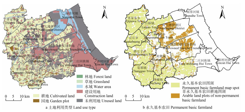
图1黄骅市2018年土地利用类型及永久基本农田空间分布
Figure1.Spatial distribution maps of land use types in 2018 and permanent basic farmland in Huanghua City
 下载: 全尺寸图片幻灯片
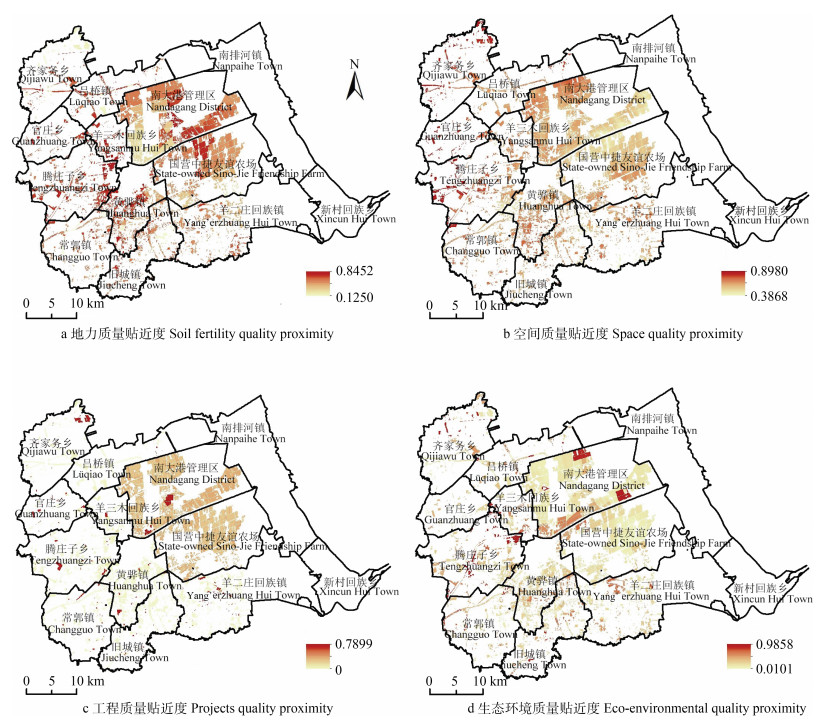
图2黄骅市非基本农田耕地质量评价
Figure2.Quality evaluation of non-basic farmland in Huanghua City
下载: 全尺寸图片幻灯片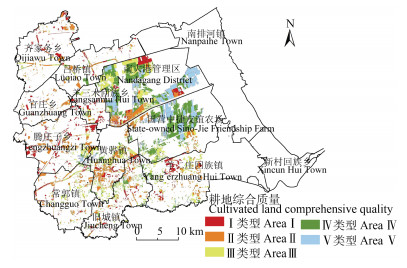
图3黄骅市非永久基本农田耕地综合质量空间分布
Figure3.Comprehensive quality spatial distribution of non-permanent basic farmland in Huanghua City
下载: 全尺寸图片幻灯片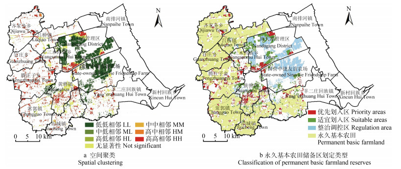
图4黄骅市永久基本农田储备区划定
Figure4.Delineation of permanent basic farmland reserve areas in Huanghua City
下载: 全尺寸图片幻灯片表1耕地入选永久基本农田储备区的综合质量评价指标体系
Table1.Indexes system of comprehensive quality evaluation for delimitating permanent basic farmland reserve area
| 决策目标 Decision goal | 评价要素(权重) Evaluation factor (weight) | 评价指标(权重) Evaluation index (weight) | 选取依据Selection reason | 效应Effect |
| 永久基本农田储备区划定 Delineation of permanent basic farmland reserve area | 地力质量 Soil fertility quality (0.3499) | 表层土壤质地 Surface soil texture (0.1020) | 土壤物理适宜性 Soil physical suitability | + |
| 有机质含量 Organic matter content (0.0063) | 土壤肥力 Soil fertility | + | ||
| 剖面构型 Profile configuration (0.1008) | 蓄水保肥能力 Water and fertilizer conservation | 适度 Moderation | ||
| 盐渍化程度 Degree of salinization (0.0505) | 作物生长环境 Crop growth environment | ? | ||
| pH (0.0584) | 土壤化学环境 Soil chemical environment | 适度 Moderation | ||
| 地下水埋深 Groundwater depth (0.0319) | 次生盐渍化风险 Risk of secondary salinization | + | ||
| 空间质量 Spatial quality (0.3243) | 图斑规模 Map size (0.0044) | 可机械化程度 Mechanization degree | + | |
| 图斑规整度 Pattern regularity (0.0536) | 可耕作潜力 Tillage potential | ? | ||
| 坡度 Slope (0.0375) | 田块平整度 Flatness of fields | ? | ||
| 距交通干线距离 Distance to main traffic lines (0.0423) | 耕作便捷度 Farming convenience | ? | ||
| 距城镇距离 Distance to town (0.0540) | 城市干扰度 Urban interference with arable land | + | ||
| 距农村居民点距离 Distance to rural settlements (0.0603) | 管理便捷度 Convenience of management | ? | ||
| 距基本农田距离 Distance to basic farmland (0.0722) | 集中连片度 Degree of concentration | ? | ||
| 工程质量 Projects quality (0.1684) | 灌溉保证率 Irrigation assurance rate (0.0894) | 抗旱能力 Drought resistance ability | + | |
| 田间道路密度 Field road density (0.0395) | 田块内部通达性 Accessibility within the field | + | ||
| 沟渠密度 Channel density (0.0395) | 排涝能力 Drainage capacity | + | ||
| 生态环境质量 Eco-environment quality (0.1574) | 生态用地覆盖率 Ecological land cover rate (0.0940) | 生态调适能力 Ecological adaptation capacity | + | |
| 土壤污染程度 Soil contamination (0.0634) | 土壤重金属污染 Heavy metal contamination in soil | ? |
下载: 导出CSV表2耕地综合质量评价部分指标分级标准
Table2.Score standards of some indexes of comprehensive quality evaluation of farmland
| 指标分值 Index score | 表层土壤质地 Soil texture | 有机质含量 Soil organic matter content (g?kg?1) | 剖面构型 Soil profile pattern | 盐渍化程度 Salinity degree | pH | 灌溉保证率 Probability of irrigation |
| 10 | — | — | — | — | — | — |
| 20 | — | < 6 | — | — | — | — |
| 30 | — | — | — | — | — | 无灌溉条件 No irrigation condition |
| 40 | 砾质土 Gravel soil | 6~10 | 通体砂、通体砾 Sand, gravelly soil | 重度 Severe | — | — |
| 50 | — | 10~15 | 黏/砂/砂 Clay / sand / sand | — | — | — |
| 60 | — | 15~20 | 壤/砂/砂 Loam / sand / sand | 中度 Moderate | — | — |
| 70 | 砂土 Sand | — | 砂/黏/砂 Sand / glay / sand | — | 7.9~8.5, 5.0~5.5 | 一般满足 General satisfaction |
| 80 | — | > 20 | 黏/砂/黏、通体黏 Clay / sand / clay, clay | 轻度 Mild | — | — |
| 90 | 黏土 Clay | — | 壤/黏/黏、壤/砂/壤、砂/黏/黏 Loam / clay / clay, loam / sand / loam, sand / clay / clay | — | 7.5~7.9 | 基本满足 Basic meet |
| 100 | 壤土 Loam | — | 通体壤、壤/黏/壤 Loam, loam / clay / loam | 无盐化 No | 6.0~7.5 | 充分满足 Fully meet |
| “—“表示质量评价指标未赋该类分值。“—” indicates that this score is not assigned to the quality assessment index. | ||||||
下载: 导出CSV表3基本农田储备区划定组合矩阵
Table3.Composite matrix for the delineation of permanent basic farmland reserve areas
| 耕地质量 Quality of cultivated land | HH, HM | HL, MM, N | ML, LL |
| Ⅰ级Level Ⅰ | 优先划入区Priority area | 适宜划入区Suitable area | — |
| Ⅱ级Level Ⅱ | 优先划入区Priority area | 适宜划入区Suitable area | — |
| Ⅲ级Level Ⅲ | 优先划入区Priority area | 适宜划入区Suitable area | 适宜划入区Suitable areas |
| Ⅳ级Level Ⅳ | — | 适宜划入区Suitable area | 整治调控区Regulation area |
| Ⅴ级Level Ⅴ | — | 整治调控区Regulation area | 整治调控区Regulation area |
| HH为高高相邻, HM为高中相邻, HL为高低相邻, MM为中中相邻, N为无显著聚类, ML为中低相邻, LL为低低相邻。HH is adjacent to each other of the high-quality areas of cultivated land, HM is that the high-quality area is adjacent to the median-quality area of cultivated land, MM is adjacent to each other of the median-quality areas of cultivated land, N is no significant clustering of cultivated land mass distribution, ML is that the median-quality area is adjacent to the low-quality area of cultivated land, LL is adjacent to each other of the low-quality areas of cultivated land. | |||
下载: 导出CSV参考文献
| [1] | 钱凤魁, 王卫雯, 张靖野, 等. 近30 a基本农田领域研究态势的可视化分析[J]. 自然资源学报, 2017, 32(12): 2160-2170 doi: 10.11849/zrzyxb.20161048 QIAN F K, WANG W W, ZHANG J Y, et al. Visual analysis of research situation in the basic farmland field from 1986 to 2015[J]. Journal of Natural Resources, 2017, 32(12): 2160-2170 doi: 10.11849/zrzyxb.20161048 |
| [2] | 杨绪红, 金晓斌, 贾培宏, 等. 多规合一视角下县域永久基本农田划定方法与实证研究[J]. 农业工程学报, 2019, 35(2): 250-259 https://www.cnki.com.cn/Article/CJFDTOTAL-NYGU201902032.htm YANG X H, JIN X B, JIA P H, et al. Designation method and demonstration of permanent basic farmland in county level on view of multi-planning integration[J]. Transactions of the Chinese Society of Agricultural Engineering, 2019, 35(2): 250-259 https://www.cnki.com.cn/Article/CJFDTOTAL-NYGU201902032.htm |
| [3] | 姚敏, 杨帆, 黎韶光. 永久基本农田储备区的划定及管理[J]. 中国土地, 2019, (10): 24-26 https://www.cnki.com.cn/Article/CJFDTOTAL-ZGTD201910007.htm YAO M, YANG F, LI S G. Delineation and administration of permanent basic farmland reserves[J]. China Land, 2019, (10): 24-26 https://www.cnki.com.cn/Article/CJFDTOTAL-ZGTD201910007.htm |
| [4] | 姚敏, 李磊, 武建飞. 永久基本农田储备区数据库建设及应用[J]. 国土资源信息化, 2019, (4): 20-23 https://www.cnki.com.cn/Article/CJFDTOTAL-GTZX201904004.htm YAO M, LI L, WU J F. Database construction and application of permanent basic farmland reserve zone[J]. Land and Resources Informatization, 2019, (4): 20-23 https://www.cnki.com.cn/Article/CJFDTOTAL-GTZX201904004.htm |
| [5] | 董光龙, 赵轩, 刘金花, 等. 基于耕地质量评价与空间集聚特征的基本农田划定研究[J]. 农业机械学报, 2020, 51(2): 133-142 https://www.cnki.com.cn/Article/CJFDTOTAL-NYJX202002015.htm DONG G L, ZHAO X, LIU J H, et al. Prime cropland assignment based on cultivated land quality evaluation and spatial cluster pattern[J]. Transactions of the Chinese Society for Agricultural Machinery, 2020, 51(2): 133-142 https://www.cnki.com.cn/Article/CJFDTOTAL-NYJX202002015.htm |
| [6] | 汤峰, 徐磊, 张蓬涛, 等. 县域高标准基本农田建设适宜性评价与优先区划定[J]. 农业工程学报, 2019, 35(21): 242-251 doi: 10.11975/j.issn.1002-6819.2019.21.030 TANG F, XU L, ZHANG P T, et al. Suitability evaluation and priority area delineation of high standard basic farmland construction at county level[J]. Transactions of the Chinese Society of Agricultural Engineering, 2019, 35(21): 242-251 doi: 10.11975/j.issn.1002-6819.2019.21.030 |
| [7] | 曹丽萍, 罗志军, 冉凤维, 等. 基于耕地质量和空间集聚格局的县域基本农田划定[J]. 水土保持研究, 2018, 25(4): 349-355, 364 https://www.cnki.com.cn/Article/CJFDTOTAL-STBY201804055.htm CAO L P, LUO Z J, RAN F W, et al. Distribution of prime farmland based on cultivated land quality and spatial agglomeration pattern at county scale[J]. Research of Soil and Water Conservation, 2018, 25(4): 349-355, 364 https://www.cnki.com.cn/Article/CJFDTOTAL-STBY201804055.htm |
| [8] | 曾吉彬, 邵景安, 谢德体. 基于遥感影像的重庆高标准基本农田建设难度与时序分析[J]. 农业工程学报, 2018, 34(23): 267-278 doi: 10.11975/j.issn.1002-6819.2018.23.035 ZENG J B, SHAO J A, XIE D T. Study on difficulty and time sequence of construction of high standard basic farmland in Chongqing based on remote sensing images[J]. Transactions of the Chinese Society of Agricultural Engineering, 2018, 34(23): 267-278 doi: 10.11975/j.issn.1002-6819.2018.23.035 |
| [9] | 信桂新, 杨朝现, 杨庆媛, 等. 用熵权法和改进TOPSIS模型评价高标准基本农田建设后效应[J]. 农业工程学报, 2017, 33(1): 238-249 https://www.cnki.com.cn/Article/CJFDTOTAL-NYGU201701033.htm XIN G X, YANG C X, YANG Q Y, et al. Post-evaluation of well-facilitied capital farmland construction based on entropy weight method and improved TOPSIS model[J]. Transactions of the Chinese Society of Agricultural Engineering, 2017, 33(1): 238-249 https://www.cnki.com.cn/Article/CJFDTOTAL-NYGU201701033.htm |
| [10] | 郑新奇, 杨树佳, 象伟宁, 等. 基于农用地分等的基本农田保护空间规划方法研究[J]. 农业工程学报, 2007, 23(1): 66-71, 292 doi: 10.3321/j.issn:1002-6819.2007.01.011 ZHENG X Q, YANG S J, XIANG W N, et al. Spatial planning method for the basic farmland protection based on the farmland classification[J]. Transactions of the Chinese Society of Agricultural Engineering, 2007, 23(1): 66-71, 292 doi: 10.3321/j.issn:1002-6819.2007.01.011 |
| [11] | 闫宁, 郑宏刚, 余建新, 等. 农用地分等在基本农田划分中的应用研究[J]. 国土与自然资源研究, 2009, (3): 28-30 doi: 10.3969/j.issn.1003-7853.2009.03.015 YAN N, ZHENG H G, YU J X, et al. Research on applications of agricultural land classification in division of prime farmland[J]. Territory & Natural Resources Study, 2009, (3): 28-30 doi: 10.3969/j.issn.1003-7853.2009.03.015 |
| [12] | 任艳敏, 唐秀美, 刘玉, 等. 考虑耕地生态质量的基本农田划定方法[J]. 农业工程学报, 2014, 30(24): 298-307, 53-54 doi: 10.3969/j.issn.1002-6819.2014.24.037 REN Y M, TANG X M, LIU Y, et al. Demarcating method of prime farmland considering ecological quality of cultivated land[J]. Transactions of the Chinese Society of Agricultural Engineering, 2014, 30(24): 298-307, 53-54 doi: 10.3969/j.issn.1002-6819.2014.24.037 |
| [13] | 刘春芳, 乌亚汗, 王川. 基于生态服务功能提升的高标准农田建设的分区方法[J]. 农业工程学报, 2018, 34(15): 264-272, 313 doi: 10.11975/j.issn.1002-6819.2018.15.033 LIU C F, WU Y H, WANG C. Zoning method for well-facilitated farmland construction based on improvement of ecological services[J]. Transactions of the Chinese Society of Agricultural Engineering, 2018, 34(15): 264-272, 313 doi: 10.11975/j.issn.1002-6819.2018.15.033 |
| [14] | 姜广辉, 张瑞娟, 张翠玉, 等. 基于空间集聚格局和边界修正的基本农田保护区划定方法[J]. 农业工程学报, 2015, 31(23): 222-229 doi: 10.11975/j.issn.1002-6819.2015.23.030 JIANG G H, ZHANG R J, ZHANG C Y, et al. Approach of land use zone for capital farmland protection based on spatial agglomeration pattern and boundaries modification[J]. Transactions of the Chinese Society of Agricultural Engineering, 2015, 31(23): 222-229 doi: 10.11975/j.issn.1002-6819.2015.23.030 |
| [15] | 韩帅, 李颖, 李双异, 等. 辽北旱作区高标准基本农田建设选址与建设模式研究[J]. 中国人口·资源与环境, 2015, 25(S1): 439-442 https://www.cnki.com.cn/Article/CJFDTOTAL-ZGRZ2015S1108.htm HAN S, LI Y, LI S Y, et al. Siting and construction mode of high-standard basic farmland for the dry land in north Liaoning[J]. China Population, Resources and Environment, 2015, 25(S1): 439-442 https://www.cnki.com.cn/Article/CJFDTOTAL-ZGRZ2015S1108.htm |
| [16] | 慕正隆, 石培基, 刘春芳, 等. 基于形态优化和边界识别的基本农田保护区研究[J]. 资源科学, 2018, 40(1): 22-31 https://www.cnki.com.cn/Article/CJFDTOTAL-ZRZY201801003.htm MU Z L, SHI P J, LIU C F, et al. Basic farmland protection area based on morphological optimization and boundary identification[J]. Resources Science, 2018, 40(1): 22-31 https://www.cnki.com.cn/Article/CJFDTOTAL-ZRZY201801003.htm |
| [17] | 边振兴, 杨子娇, 钱凤魁, 等. 基于LESA体系的高标准基本农田建设时序研究[J]. 自然资源学报, 2016, 31(3): 436-446 BIAN Z X, YANG Z J, QIAN F K, et al. Study on time sequence of high-standard prime farmland based on LESA[J]. Journal of Natural Resources, 2016, 31(3): 436-446 |
| [18] | 李龙, 吴大放, 刘艳艳. 基于四象限法的城市周边永久基本农田划定研究——基于自然质量和建设稳定性[J]. 中国农业资源与区划, 2020, 41(5): 87-97 https://www.cnki.com.cn/Article/CJFDTOTAL-ZGNZ202005015.htm LI L, WU D F, LIU Y Y. Study on permanent basic farmland demarcation around the city with the fourquadrant method-based on natural quality and construction stability[J]. Chinese Journal of Agricultural Resources and Regional Planning, 2020, 41(5): 87-97 https://www.cnki.com.cn/Article/CJFDTOTAL-ZGNZ202005015.htm |
| [19] | 蔡洁, 李世平. 基于熵权可拓模型的高标准基本农田建设项目社会效应评价[J]. 中国土地科学, 2014, 28(10): 40-47 doi: 10.3969/j.issn.1001-8158.2014.10.006 CAI J, LI S P. Social effects evaluation of high-standard primary farmland construction project based on entropy-weighted method and extension model[J]. China Land Sciences, 2014, 28(10): 40-47 doi: 10.3969/j.issn.1001-8158.2014.10.006 |
| [20] | 杨建宇, 张欣, 徐凡, 等. 基于TOPSIS和局部空间自相关的永久基本农田划定方法[J]. 农业机械学报, 2018, 49(4): 172-180 https://www.cnki.com.cn/Article/CJFDTOTAL-NYJX201804020.htm YANG J Y, ZHANG X, XU F, et al. Designation method of permanent basic farmland based on TOPSIS and local spatial autocorrelation[J]. Transactions of the Chinese Society for Agricultural Machinery, 2018, 49(4): 172-180 https://www.cnki.com.cn/Article/CJFDTOTAL-NYJX201804020.htm |
| [21] | 谭少军, 邵景安, 张琳, 等. 西南丘陵区高标准基本农田建设适宜性评价与选址——以重庆市垫江县为例[J]. 资源科学, 2018, 40(2): 310-325 https://www.cnki.com.cn/Article/CJFDTOTAL-ZRZY201802008.htm TAN S J, SHAO J A, ZHANG L, et al. Suitability assessment and sites of high standard basic farmland in the southwest hilly area of China[J]. Resources Science, 2018, 40(2): 310-325 https://www.cnki.com.cn/Article/CJFDTOTAL-ZRZY201802008.htm |
| [22] | 林超, 马智民. 基于CLUE-S模型的临潼区基本农田划定研究[J]. 测绘与空间地理信息, 2014, 37(1): 25-29 doi: 10.3969/j.issn.1672-5867.2014.01.009 LIN C, MA Z M. The research on basic farmland demarcated based on the CLUE-S model in Lintong District[J]. Geomatics & Spatial Information Technology, 2014, 37(1): 25-29 doi: 10.3969/j.issn.1672-5867.2014.01.009 |
| [23] | 关小东, 何建华. 基于贝叶斯网络的基本农田划定方法[J]. 自然资源学报, 2016, 31(6): 1061-1072 https://www.cnki.com.cn/Article/CJFDTOTAL-ZRZX201606015.htm GUAN X D, HE J H. Prime farmland protection zoning based on Bayesian network[J]. Journal of Natural Resources, 2016, 31(6): 1061-1072 https://www.cnki.com.cn/Article/CJFDTOTAL-ZRZX201606015.htm |
| [24] | 臧亮, 张贵军, 张慧, 等. 黄骅市土壤重金属空间变异特征及污染评价[J]. 水土保持研究, 2017, 24(5): 337-342 https://www.cnki.com.cn/Article/CJFDTOTAL-STBY201705053.htm ZANG L, ZHANG G J, ZHANG H, et al. Assessment on spatial variability and pollution of the heavy metal in soil of Huanghua City[J]. Research of Soil and Water Conservation, 2017, 24(5): 337-342 https://www.cnki.com.cn/Article/CJFDTOTAL-STBY201705053.htm |
| [25] | 胡占森, 张永福, 赵芳. 基于"三调"数据的永久基本农田储备区划定研究——以阿克苏市为例[J]. 安徽农业科学, 2020, 48(13): 53-58 doi: 10.3969/j.issn.0517-6611.2020.13.017 HU Z S, ZHANG Y F, ZHAO F. Research on delimitation of permanent prime farmland reserve area based on the third national land survey data-A case of Aksu[J]. Journal of Anhui Agricultural Sciences, 2020, 48(13): 53-58 doi: 10.3969/j.issn.0517-6611.2020.13.017 |
| [26] | 吕雅慧, 郧文聚, 张超, 等. 基于TOPSIS和BP神经网络的高标准农田综合识别[J]. 农业机械学报, 2018, 49(3): 196-204 https://www.cnki.com.cn/Article/CJFDTOTAL-NYJX201803024.htm LYU Y H, YUN W J, ZHANG C, et al. Multi-characteristic comprehensive recognition of well-facilitied farmland based on TOPSIS and BP neural network[J]. Transactions of the Chinese Society for Agricultural Machinery, 2018, 49(3): 196-204 https://www.cnki.com.cn/Article/CJFDTOTAL-NYJX201803024.htm |
| [27] | 李玲, 张少凯, 张欢欢, 等. 基于农用地分等和地球化学调查的开封市大蒜适宜性评价及种植区划[J]. 资源科学, 2015, 37(2): 370-378 https://www.cnki.com.cn/Article/CJFDTOTAL-ZRZY201502018.htm LI L, ZHANG S K, ZHANG H H, et al. The planting suitability and division of garlic based on agricultural land classification and geochemical survey in Kaifeng City[J]. Resources Science, 2015, 37(2): 370-378 https://www.cnki.com.cn/Article/CJFDTOTAL-ZRZY201502018.htm |
| [28] | 匡丽花, 叶英聪, 赵小敏, 等. 基于改进TOPSIS方法的耕地系统安全评价及障碍因子诊断[J]. 自然资源学报, 2018, 33(9): 1627-1641 https://www.cnki.com.cn/Article/CJFDTOTAL-ZRZX201809013.htm KUANG L H, YE Y C, ZHAO X M, et al. Evaluation and obstacle factor diagnosis of cultivated land system security in Yingtan City based on the improved TOPSIS method[J]. Journal of Natural Resources, 2018, 33(9): 1627-1641 https://www.cnki.com.cn/Article/CJFDTOTAL-ZRZX201809013.htm |
| [29] | 吕广斌, 廖铁军, 姚秋昇, 等. 基于DPSIR-EES-TOPSIS模型的重庆市土地生态安全评价及其时空分异[J]. 水土保持研究, 2019, 26(6): 249-258, 266 https://www.cnki.com.cn/Article/CJFDTOTAL-STBY201906039.htm LYU G B, LIAO T J, YAO Q S, et al. Spatiotemporal variation and land ecological security and its evaluation in Chongqing City based on DPSIR-EES-TOPSIS model[J]. Research of Soil and Water Conservation, 2019, 26(6): 249-258, 266 https://www.cnki.com.cn/Article/CJFDTOTAL-STBY201906039.htm |
| [30] | 宋泽明, 宁凌. 基于DPSIR-TOPSIS模型的我国沿海省份海洋资源环境承载力评价及障碍因素研究[J]. 生态经济, 2020, 36(8): 154-160, 212 https://www.cnki.com.cn/Article/CJFDTOTAL-STJJ202008026.htm SONG Z M, NING L. Evaluation and obstacle factors of marine resources and environment carrying capacity of coastal provinces and cities in China based on DPSIR-TOPSIS model[J]. Ecological Economy, 2020, 36(8): 154-160, 212 https://www.cnki.com.cn/Article/CJFDTOTAL-STJJ202008026.htm |
| [31] | 王春懿, 梁川, 赵璐, 等. 基于正交投影法改进TOPSIS模型的宁夏农业干旱风险评价[J]. 灌溉排水学报, 2018, 37(1): 113-120 https://www.cnki.com.cn/Article/CJFDTOTAL-GGPS201801017.htm WANG C Y, LIANG C, ZHAO L, et al. Assessment of agricultural drought risk based on improved TOPSIS method in Ningxia[J]. Journal of Irrigation and Drainage, 2018, 37(1): 113-120 https://www.cnki.com.cn/Article/CJFDTOTAL-GGPS201801017.htm |
| [32] | 仉振宇, 朱记伟, 解建仓, 等. 近25年来大西安地区土地利用时空格局变化和热区诊断分析[J]. 西安理工大学学报, 2020, 36(2): 159-169 https://www.cnki.com.cn/Article/CJFDTOTAL-XALD202002005.htm ZHANG Z Y, ZHU J W, XIE J C, et al. Spatial-temporal changes of land use and hot zone diagnosis analysis in the past 25 years of the Great Xi'an area[J]. Journal of Xi'an University of Technology, 2020, 36(2): 159-169 https://www.cnki.com.cn/Article/CJFDTOTAL-XALD202002005.htm |
