 ,1,2, 王帅1, 赵文武1, 李琰1
Research progress of human-earth system dynamics based on spatial resilience theory
LIU Yanxu1, FU Bojie,1,2, WANG Shuai1, ZHAO Wenwu1, LI Yan1通讯作者:
收稿日期:2019-05-5修回日期:2020-02-3网络出版日期:2020-05-25
| 基金资助: |
Received:2019-05-5Revised:2020-02-3Online:2020-05-25
| Fund supported: |
作者简介 About authors
刘焱序(1988-),男,陕西西安人,讲师,主要从事综合自然地理与景观生态学研究E-mail:yanxuliu@bnu.edu.cn。

摘要
关键词:
Abstract
Keywords:
PDF (1459KB)元数据多维度评价相关文章导出EndNote|Ris|Bibtex收藏本文
本文引用格式
刘焱序, 傅伯杰, 王帅, 赵文武, 李琰. 空间恢复力理论支持下的人地系统动态研究进展. 地理学报[J], 2020, 75(5): 891-903 doi:10.11821/dlxb202005001
LIU Yanxu.
人地系统(亦称人地关系地域系统,通常译为Human-Earth Systems),是由地理环境和人类活动两个子系统交错构成的复杂的开放的巨系统,是地理学研究的核心[1]。人地系统的概念表现了人与地在特定的地域中相互联系、相互作用而形成的一种动态结构,包含了地域功能性、系统结构化、时空变异有序过程、人地系统效应差异性及可调控性等诸多系统特质[2,3]。从生态学、环境科学与社会科学交叉的学科视角出发,相似的概念界定也被表述为人类与自然耦合系统(Coupled Human and Natural Systems, CHANS或Coupled Human-Environment Systems, CHES)和社会—生态系统(Social-Ecological Systems, SES)[4,5]。揭示人地系统要素相互作用的动态机制与演化趋势,达成人地系统要素与过程演化的动态匹配,是人地系统研究的关键内容,也是支撑区域可持续发展的理论基础[6,7]。
构建计量模型刻画地球系统和人类系统的相互影响与反馈的动态运行过程,可以为区域可持续发展管理实践提供重要科学支撑[8,9]。然而作为复杂系统,人地系统动态格局、非线性变化、要素叠加驱动等复杂性影响了对人地系统动态过程的解读,亟待在人地系统动态研究中构建更有力的复杂系统描述指标体系[10]。从社会—生态系统理论的重要概念——恢复力出发,本文拟探讨空间恢复力(Spatial Resilience)作为人地系统动态研究重要指标的可行性,综述其概念内涵、研究进展,研讨其需求指向与指标体系,从而进一步丰富人地系统动态研究视角,为区域人地关系的解析提供新的空间解读途径。
1 空间恢复力概念内涵
1.1 从社会—生态系统恢复力到空间恢复力
1973年Holling定义了生态学研究中的系统恢复力,将其表述为系统吸收状态变量、驱动变量和参数的变化并维持系统稳定的能力[11]。21世纪以来,社会—生态系统恢复力一词被广泛使用,上述概念也被沿用并引申为:社会—生态系统受到干扰后的功能维持和控制能力,由系统承受且可以保持系统结构、功能、特性及其反馈在不发生改变时的干扰大小体现[12,13]。系统自身的稳定性、受到干扰后的自组织能力、适应干扰的学习和调节过程是系统恢复力研究所关注的核心内容[14]。在适应性循环、球杯模型等一系列概念模型的支持下[15],社会—生态系统恢复力的概念内涵已经相对成熟,并应用于生态学、地理学、灾害学、城乡规划等各个领域[16,17]。除恢复力外,脆弱性、适应能力等也是解读社会—生态系统的关键概念[18,19]。因而需要回答:为什么要研究恢复力而不是脆弱性?Cutter等将脆弱性、适应能力和恢复力的关系总结为图1,并认为脆弱性和恢复力所关注问题的侧重点不一致,倾向于采用图1f的概念框架[20]。具体而言,包括暴露、敏感性和适应等概念的脆弱性是描述系统内在特征,可以存在于事件发生之前;而恢复力是事件发生时的吸收能力,以及事件发生后的复原能力[21]。因此,恢复力相较于脆弱性在内涵上更能反映系统在某种驱动因素所用下产生的动态过程。此外,人地系统动态建模中着重关注系统过程的边界条件,而恢复力研究着重强调系统的阈值,认为超过阈值后系统会发生不可逆的转变[22],进一步体现了恢复力概念在描述人地系统动态过程中的适用性。
图1
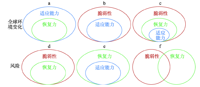 新窗口打开|下载原图ZIP|生成PPT
图1恢复力—脆弱性—适应能力概念关联(改自文献[20])
Fig. 1Relationship of resilience, vulnerability and adaptive capacity (Revised from [20])
从景观生态学视角出发,Cumming提出了空间恢复力的概念,将其界定为系统内外相关变量空间变化在多时空尺度上对系统恢复力的影响(也被系统恢复力所影响)[23]。空间恢复力的主要内生变量包括系统组分及其交互作用的空间布局,大小、形状、边界数量和性质等系统空间属性,影响恢复力的内在相位空间变化,以及由空间位置函数表示的独特系统属性;空间恢复力的主要外生变量包括基质、连通性以及所产生的空间动态[23]。异质的土地覆被与土地利用形成景观单元,构成了空间恢复力的研究景观载体[24]。空间恢复力相比传统的恢复力研究更关注位置、连通性、基质,认为不同尺度格局与过程的空间变化会影响也被影响于局部系统的恢复力,是景观生态学、恢复力与可持续性理论的整合[25]。而在达成景观可持续性的途径中,则需要以实验的方式探索不同景观管理方式下的生态系统服务供给,依托社会学习机制完善景观规划、优化景观管理方式,从而强化生态系统服务供给,更有效的满足不同社会群体的福祉需求[26]。可见,空间恢复力是从多尺度的时空动态视角切入社会—生态系统恢复力理论,以景观为对象作为解读系统恢复力的载体。
1.2 空间恢复力与人地系统动态
人地系统是地理学研究的核心,研究重点是人地系统的优化,吴传钧院士这一学术思想始终具有旺盛的生命力[2,3]。为了更有效地描述人与地在特定的地域中相互联系、相互作用而形成的这种动态结构[1],本文认为尚需要通过当前更先进的研究手段进一步回答几个基本理论问题。① 如何刻画人地系统的结构?② 如何表征人地系统的动态?③ 什么尺度可以更有效的观察人地系统各种变量间的关系?④ 人地系统优化调控的可量化目标是什么?⑤ 提升区域人地系统整体功能的关键现实途径是什么?尽管上述基本问题早以不同的表述形式引起地理学界的广泛关注,但由于人地关系命题所涉及内容众多、地域系统的关键变量不够明确,可应用于各种地域人地关系调控的理论模式和方法体系尚较为宽泛模糊,区域人地系统优化调控的具体途径也并不十分清晰[27]。因此,为避免人地系统这一宏大命题在具体定量研究中难于操作,亟待寻求更具针对性理论模式和可定量化的指标体系。由空间恢复力初始概念界定可知,空间恢复力是社会—生态系统恢复力在景观维度上的投射,是实现该复杂系统可持续性的有力抓手。而值得注意的是,尽管社会—生态系统与人地系统内涵相似,但从不同的学科背景出发,二者的语义仍有细微差别。地理学是研究地理要素和地理综合体的空间分异规律、时间演变过程及区域特征的学科,作为地理学研究核心内容之一的人地系统动态的刻画有必要强调区域格局与过程耦合[28],而对空间格局的表征并不是社会—生态系统研究的主体[5]。一方面恢复力语境所描述的非线性动态、阈值、不确定性是复杂系统动态研究的关键环节[29];另一方面空间差异作为地理学研究的一个本源需要在人地系统动态的刻画中得到聚焦[30]。因而在语义上,空间恢复力基于其明确的复杂系统空间内涵,有潜力成为人地系统动态过程的有力解读工具。驱动人地系统动态变化的过程可以被理解为空间中系统内外的干扰过程、恢复过程、转化过程,因而注重描述上述三项过程的空间恢复力理论是回答上述五项理论问题中“如何表征人地系统的动态”的重要方式,并可以兼顾特征尺度、优化目标等议题。据此,值得从地理学视角出发扩展空间恢复力相关概念,应用于人地系统动态的相关研究中,为针对性理论模式和可定量化指标体系的塑造提供新途径。
总结社会—生态系统和人地系统相关理论,本文将人地系统视角下的空间恢复力定义为:以保障人地系统结构稳定为目标的地域空间整体对自然和社会扰动的吸收、复原或转化能力。其中吸收是指地域空间中的自然、社会要素消纳了干扰,人地系统结构并未改变,例如城市景观规划强调的低影响开发;复原是指干扰事件消除后,人地系统结构可以在相对短时间内从不稳定回到稳定状态,例如在原址上进行的灾后重建和生态脆弱区的自然或人工生态恢复;转化是指人地系统结构从原先的稳态过渡到另一种稳态,如生态移民和城市绿色基础设施建设。而在研讨因地制宜的空间治理途径时,上述三种方式是可以同时存在的,从而形成提升空间恢复力的理论模式,用于解构人地系统动态过程、助力人地系统优化调控。
2 人地系统视角下的空间恢复力研究进展
“人地关系是否协调抑或矛盾,不决定于地而决定于人”[2]。从空间恢复力的内涵出发,系统的自然和社会空间变量既受到空间恢复力影响,也被空间恢复力所影响,这些过程都可以被归结为“人”对“地”的治理或适应。从不同的侧面观察系统的动态过程,可以得到三方面解读:从自然维度出发的政策与生态系统空间恢复力——“人”治理“地”提升恢复力应对系统动态变化,从社会维度出发的环境变化与社区生产生活空间恢复力——“人”适应“地”提升恢复力应对系统动态变化,从综合描述方式出发的空间恢复力评估指标——描述“人”与“地”的治理和适应关系理解系统动态变化(图2)。图2
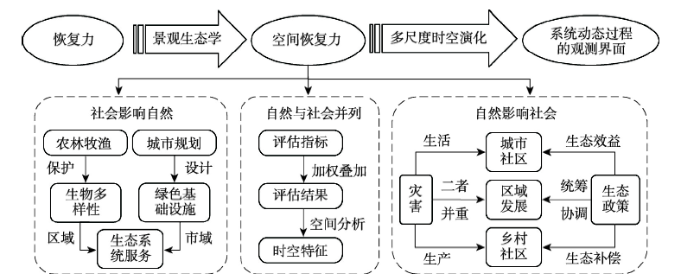 新窗口打开|下载原图ZIP|生成PPT
图2空间恢复力研究的主要内容与途径
Fig. 2Main contents and research roadmap of spatial resilience
2.1 政策与生态系统空间恢复力
有效的空间规划与管控政策是生态系统恢复的重要驱动力,基于空间恢复力的人地系统动态研究正在关注规划和政策对保护区生物多样性、城市绿色基础设施、农林景观生态质量的作用。保护区作为一种特定空间中的社会—生态系统,解析保护区恢复力的空间连通、尺度关联与政策影响[31]。Hughes等2003年发文指出,海洋保护区是最佳的珊瑚礁保护管理工具,通过构建保护区网络可以有效降低人类影响,提升珊瑚礁连通性,从而保障其恢复力[32]。Chung等提出了11个生物物理原则,用于构建植食性鱼类的保护区管理网络,支撑海洋空间规划中的珊瑚礁恢复力提升[33]。Cumming等认为保护区管理有助于提升保护区之外更大尺度上的空间恢复力,而生态、经济和社会过程的不协同会对保护区管理造成消极后果,因而保护区持久性的社会经济反馈至关重要[34]。de Vos等则以生态系统文化服务的跨尺度关联视角出发,认为生态系统服务框架对空间流动和跨尺度关联的解读有助于支持保护区管理,保护区的可持续管理不仅取决于其保护生物多样性和生态系统过程的能力,而且取决于其满足保护区内外各种社会经济需求的能力[35]。通过社会维持生态系统服务的供应和效用,是基于恢复力的生态系统管理最终目标,而景观管理可以通过发现缺失的连通性以维持脆弱系统[36]。Field等基于空间网络理论,提出了一套评估多重生态系统服务连通性的概念框架,用于描述景观中的生态系统服务空间流动,从而理解景观的恢复力[37]。在底特律应用的绿色基础设施空间规划模型显示,集成考虑雨水管理、社会脆弱性、绿色空间、空气质量、城市热岛改善、景观连通性的规划方案将有效评估特定景观中竞争和互补的生态系统服务优先级,从而使系统恢复力最大化[38]。对明尼苏达州森林景观的百年情景模拟显示,气候变化将导致恢复力降低,只有森林管理实践的根本性转型才能取得提升恢复力的模拟方案[39]。同时,应用空间恢复力指数将有助于客观评价农业景观的生态质量,地中海橄榄林比例、斑块大小和空间连通性导致的景观同质性将导致更低的空间恢复力[40]。对西班牙两个自然保护区的50年景观演化观测也显示,农村就业机会减少致使土地利用多样性丧失,景观同质化增加扰动的传播,导致恢复力的降低[41]。此外,一些国内研究也开始将恢复力作为重要指标评价土地或景观的生态状态[42]。上述案例说明,空间恢复力理论直接有助于对人地系统动态过程中区域生态系统管理实践效果进行定量化评估。
2.2 环境变化与社区生产生活空间恢复力
基于空间恢复力的人地系统动态研究也正在关注规划和政策在自然灾害恢复重建、乡村生产生活空间演化、社区适应气候变化中的作用。在地域分异角度,城市的灾害恢复力主要由经济资本驱动,而农村的灾害恢复力主要由社区资本驱动[43]。Cutter等基于社会、经济、住房和基础设施、制度、社区和环境6项恢复力评估准则发现,美国中西部和大平原的县最具灾害恢复力,而西部沿美墨边境和东部沿阿巴拉契亚山脉的县则最不具灾害恢复力[44]。Adger等认为,多层次社会网络可以强化社会和生态恢复力,管理权力需要跨级交互[45]。对人地系统中乡村生产生活空间演化的驱动力刻画是空间恢复力研究重点和难点[46]。该难点主要表现在恢复力指标间的交互作用和驱动力的持续性上。例如,山区道路扩张驱动乡村减贫,并不驱动经济增长,而经济增长却驱动着道路网络扩张;道路建设增加了山区景观的破碎度,却提高了社会连通度[47]。偏远地区人群对气候和资源变化往往表现出显著的适应能力,但又是最容易受到气候变化影响的群体之一,短期内特定的恢复力增加可能在长期内会造成更大的脆弱性[48]。欧洲14个不同国家和地区的案例也表明,提高农民在困难经济环境中坚持的能力可能会破坏更广泛地区的恢复力,而短期内农民恢复力的提高可能会削弱其未来的恢复力[49]。此类案例充分展现了空间恢复力理论在人地系统动态研究中应用时对空间、时间和尺度的全面解读能力。如何定量描述社区空间恢复力是学界研究的重点内容,恢复力建模应当具有超越社区或灾害本身具体特征的解释力[50]。在社区尺度,可以采用地理加权回归表征社区空间中灾害恢复力的地域分异规律[51],或揭示影响城市绿色基础设施的关键社会变量用于恢复力相关规划[52],但该方法对系统反馈过程的刻画有所不足。Schouten等认为农户访谈的agent模型可以在系统模拟中表现出明显优势,例如可以通过不同生态补偿条件下的空间农业环境方案模拟,理解农户对生产价格波动和生物多样性保护的决策机制,从而寻找恢复力的强化途径[53]。Kelkar等采用水文模型模拟地表径流、土壤水分发育、侧向径流和地下水补给,支撑印度村庄社区适应气候变化和水资源压力的管理决策[54]。Waters等采用中心节点网络分析法对乌干达城市化过程的研究表明,贫民个人适应能力的关键决定因素是对地点、社交网络和居住时间的依恋,贫民区的适应能力存在显著差异,其具有较强的社群和时间维度[55]。在指标方面,Frazier等认为,具有地域差异的加权指标有助于恢复力量化,时间和空间指标对灾害恢复时间线有不同的影响;针对县级尺度适应性策略的不足,社区尺度恢复力制图应当强调时间和空间指标[56]。但总体而言,目前在乡村或城市社区的恢复力研究中对研究对象空间形态和空间结构的表征仍然不足,亟待从地域空间视角出发探索恢复力的度量标准[57]。
2.3 空间恢复力综合评估指标
目前空间恢复力指标遴选及处理方式仍处于探索初期,对恢复目标和临界点的量化仍然是评估的难点。从定义出发,恢复力应该通过系统拐点所对应的阈值来表征,但实际可观测的系统崩溃毕竟少见,社会扰动的边界状态往往不能被准确认知,因而有必要采用替代指标进行建模[58]。Chuang等从空间关系出发,将社区的恢复力指标分为本地、远程关联、社会生态耦合三类,并强调了预警信号、跨尺度与连通性三项重要属性[59]。然而,塑造社会恢复力的过程主要取决于更大尺度上的资本—社会关系,导致地域恢复力在空间尺度上存在错位[60]。Allen等认为景观中相关变量的空间结构和变化直接影响着空间恢复力,获得长期、空间明确的数据对于量化空间恢复力至关重要[61]。但数据的时空分辨率又很难同时保障,从而导致空间恢复力制图中指标往往是不全面的[62]。基于变化、多样性、自组织和学习等维度的空间形态学分析手段亟待被纳入恢复力研究中[63]。近年来,空间恢复力综合评估案例开始出现。Zhou等将地域空间中的灾害恢复力解构为内在恢复力和适应恢复力,采用收入多样性指数和农业收入依赖性指数表征[64]。Ge等将农业劳动力迁移和耕地转换作为粮食生产系统的空间恢复力表征指标[65]。Li等通过生态敏感性、水质和植被覆盖等指标,实现了湿地空间恢复力的制图[66]。Luo等基于植被指数、夜间灯光等数据的趋势分析,刻画了城市景观空间恢复力的时空特征[67]。Salvati等采用气候、土壤、植被和土地管理四个质量指数识别环境敏感区域,从而实现景观尺度上的土地退化潜在恢复力制图[68]。也有研究将各种景观指数直接作为空间恢复力的重要表征方式[69]。此外,一些****将恢复力解读为能够适应而将脆弱性解读为不能适应,在精度较高的地域空间中建构相对复杂的脆弱性指标体系解读恢复力[70,71]。基于连通性的网络分析有效刻画了地理区位特征,成为空间恢复力的有力量化途径[72]。然而对跨尺度的社会网络联系论证仍以描述性分析为主,缺乏有效的恢复力定量指标[73]。考虑到恢复力的尺度特征,Kelly等将社区问卷资料和区域统计资料相结合,用于定性和定量讨论社区恢复力、森林生态系统和土地退化之间复杂的相互关系[74]。Li等采用褶皱模型、尖头模型、燕尾模型和蝴蝶模型4种灾变理论模型量化城市人地系统的恢复力,为适应性循环理论提供了定量解读方式[75]。而在城市水环境恢复力等特定的评价模型中,国家水质标准可以作为一种明确的阈值,是城市人地系统拐点定量刻画的一项有力指标[76]。但是总体而言,空间恢复力综合指标体系和处理方法仍处在案例研究阶段,尚未能被全面纳入空间规划实践之中[77],很难达成人地系统优化的最终目标。
3 面向人地系统动态过程的空间恢复力研究需求
空间恢复力的概念强调内生和外生快慢变量的时空关系、跨尺度特征和变化阈值[24],正是描述人地系统动态过程、实现复杂人地系统模拟的有力概念抓手。但是,空间恢复力自身定量化的困难性导致了目前的空间恢复力研究水平尚不足以全面刻画人地系统动态过程。鉴于此,建议从系统可持续性空间状态和系统动态过程空间阈值入手,以服务国家生态保护与社会进步重大需求为导向,实现空间恢复力议题从理论研究走向区域实践,为应对全球变化和推动国家发展提供更加切实的科学贡献,具体表现为以下三点研究需求。3.1 认知保障系统可持续性的空间状态
人地系统以结构化的形式包含着全部地理环境和人类活动要素、过程,可以将人地系统可持续性的保障理解为可持续发展,而人地系统动态过程的明晰则是保障系统可持续性的必要途径[78]。以地域为认知单元,析取能够表征系统结构和时空分异的各种变量,模拟并预测保障系统可持续性的空间状态,是人地系统分析框架下空间恢复力研究从定性走向定量的必要途径。土地或景观变量则成为了上述模拟预测的最直观载体,认知保障人地系统可持续性的空间状态,可以被简化解读为保障社会、经济、环境可持续发展的土地系统或景观的结构和功能状态。例如Gao等针对澳大利亚经济发展、粮食生产、水资源使用、生物能源、生物燃料、温室气体减排、生物多样性(土地退化)等7个可持续发展指标,将土地利用作为介质设计了648条社会经济、环境和政策路径进行情景预测,发现资源有限的土地系统中效果抵消效应普遍存在,实现所有相关的目标几乎不太可能[79]。从空间恢复力的语境解读,可以认为人地系统在空间上的自组织动态过程中无法越过可持续发展指标所对应的理论界限,导致系统在长期运行中将趋于崩溃——不可持续。因此,需要在空间上寻求更积极的动态过程,实现系统运行状态的转化(Transformation)[80],推动系统走向可持续的运行状态。在土地系统研究或景观生态研究中定量刻画系统状态的转化,成为空间恢复力研究的方法前沿。3.2 明晰人地系统动态过程的空间阈值
空间阈值既是空间恢复力研究从理论走向实践的难点,又是空间恢复力研究从定性走向定量的突破口。“地球界限(Planetary Boundaries)”思想提出了调节地球系统稳定性和恢复力的九个过程,是恢复力视角下全球人地系统过程的首个明确阈值[81,82]。地球界限思想以阈值的形式,将自然地域系统资源禀赋与人类发展紧密衔接,是当前社会—生态系统恢复力研究最有效的定量化途径。然而相比全球研究,国家和区域人地系统在日益频繁的国际贸易体系和区域物流体系下更具开放性,导致了地球界限在地域空间上的表达依然十分困难。与地球界限相对应的,是中国****在人地系统可持续框架下长期致力的资源环境承载力研究体系[83,84]。以县域单元为单位的资源环境承载力监测预警具有更鲜明的地域特色,符合空间恢复力研究对空间变量的强调。承载力在语义上可以被理解为一种系统供需关系,即比较地域系统对人类系统的资源环境供给能力和人类系统对地域资源环境的潜在需求,从而确定是否超载。日益完善的地表过程定位监测资料和资源环境开发统计资料可以为资源环境供给能力的量化提供更全面的数据支持,通过降尺度方法确定定量化的区域“界限”或景观尺度的承载力,并将其嵌入地球系统模型中,实现地域系统和人类系统两个子系统的双向耦合关系模拟[85],从而识别不同系统状态之间的拐点及其关键空间变量阈值,成为空间恢复力研究的方法前沿。3.3 满足生态保护与社会进步国家需求
乡土中国的千年传承塑造了中国农耕文明独特的人地关系,不断加速的城市化进程则铸就了全球瞩目的改革开放40年巨变。中国巨大区域资源环境禀赋、社会经济发展、人类活动方式差异下各具特色的人地关系状态孕育了进行人地系统动态研究的沃土;从南水北调、退耕还林等举世瞩目的大型生态工程,到“一带一路”倡议和新型城镇化规划等国家行动,人地系统动态研究成果也紧密联系着国家地域发展战略需求。进一步提升对异质性地表过程与人类活动互馈关系的观测、解释与预测能力,架构并实现耦合多要素、多过程、多尺度的综合决策支持系统,将成为全面支撑中国区域人地关系协调、实现区域可持续发展的重要科学保障。从土地系统和景观生态角度出发,国土空间规划、国土生态修复是推进生态文明建设的重大举措,而空间恢复力在理论上可以认知区域人地系统空间状态,在方法上可以识别关键空间变量阈值,能为国土空间规划和国土生态修复提供切实的学科支持,从而为满足国家生态保护与社会进步需求提供规划管理空间途径。总之,深化空间恢复力理论与方法,深入理解人地系统动态,有助于更加精准的模拟区域社会经济、环境和政策路径,将为全球、国家和区域生态保护、社会进步乃至可持续发展决策提供关键理论和方法支持。3.4 面向人地系统动态过程的空间恢复力指标体系研讨
有别于社会—生态系统或人类与自然耦合系统,人地系统研究着重强调地表过程的区域性。生态保护与社会进步国家需求的满足须以区域实践的途径体现,而区域人地系统可持续发展的达成很有可能受制于干旱区、农耕区、高寒地区、城市群等特定区域普遍存在的人地矛盾。在全球和国家层面,应对全球气候变化是恢复力研究的重要实践出口;但面对区域自身社会发展和环境保护的多重要求,更需要引入具体空间指标明确区域生产、生活、生态空间变化的经济、社会和环境响应,从而在地域空间中更明确的揭示人地系统动态机制。考虑到人地系统研究涉及要素众多,建立既通用又实用的空间恢复力指标难度很大。本文按照城市化地区、农产品主产区、重点生态功能区的地域划分形式,将空间恢复力代表性指标拆分为结构和功能两个维度,在结构维度上主要聚焦人地系统的空间组织指标,在功能维度上主要关注人地系统的恢复或提升效用,并列举了部分参考阈值,以供讨论和进一步完善(表1)。Tab. 1
表1
表1空间恢复力代表性指标体系研讨
Tab. 1
| 结构的空间组织 | 功能的恢复提升 | 参考阈值 | |
|---|---|---|---|
| 城市化 地区 | 空间均衡性(人口结构、产业布局、资源供给等),空间可达性(通勤成本、绿地距离等),空间公平性(教育、医疗、治安、环境治理等),空间连通性(工程基础设施、绿色基础设施),区际连通性(跨国和跨地市的人流物流信息流),城乡差异性(以上相关指标的城乡差距)等 | 经济增长潜力、社会稳定程度、文化传承与塑造、科技创新能力、人居环境与健康、生态系统调节服务、生态系统文化服务等 | 国民经济和社会发展规划、城乡总体规划和空间规划、环境容量、产业投入产出效率等 |
| 农产品 主产区 | 种植业空间适宜性(基本农田保护、高标准农田建设、耕地占补平衡、休耕轮作等)、畜牧业空间适宜性(轮牧、休牧、禁牧位置与载畜量等)、空间环境安全度(面源污染、土壤重金属等)、区域生计安全度(粮食自给率、农业就业等)、区域资源利用效率(水资源配置、劳动力占用等)、远程耦合度(如跨国贸易)等 | 粮食安全与农产品质量安全、农业现代化程度、农户生计可持续性、农村环境与健康、乡土文化传承与革新、耕地生态系统服务、草地生态系统服务等 | 国民经济和社会发展规划、乡村振兴战略和空间规划、精准扶贫指标、农业产业投入产出效率等 |
| 重点生态功能区 | 生态安全格局(源地、廊道、节点、阻力等),区域社会—生态网络结构(社会决策与生态过程的联系路径),区域生态补偿绩效(补偿成本、补偿成效、补偿外部性等),景观生态风险(如景观连通度、生态系统多样性)等 | 景观多功能性、生态系统服务流、区域生物多样性、自然资源资产或生态资产、生态功能区农户生计可持续性等 | 国民经济和社会发展规划、保护区相关规划和空间规划、长时序生态指标等 |
新窗口打开|下载CSV
4 结语
揭示人地系统要素相互作用的动态机制与演化趋势,达成人地系统要素与过程演化的动态匹配,是人地系统研究的关键内容,也是支撑区域可持续发展的理论基础。然而,传统地理学勘查、观测、记录、制图等知识描述式综合研究途径并不能准确识别地理格局与地表过程的耦合关系,容易局限于定性概念模型和发现关联规则[28];当代地理学定量研究大多遵循“还原论”思维和方法体系,又难以从系统的角度阐释结构复杂、变化多样的地理区域变化规律[11]。面向中国长期以来突出的区域经济社会发展与资源环境之间的矛盾与不协调,亟待通过更有效的理论模式和方法体系明晰人地系统动态过程,为国家和区域可持续发展提供定量化决策支持。空间恢复力可以用于描述景观维度上驱动人地系统动态变化的干扰过程、恢复过程、转变过程,为人地系统研究中理论模式和可定量化指标体系的塑造提供新途径。本文通过梳理空间恢复力理论,综述空间恢复力理论支持下的人地系统动态研究进展,展望面向人地系统动态过程的空间恢复力研究需求,研讨空间恢复力指标体系,从而推动空间恢复力理论与方法在地理学研究中的深化。期待随着空间恢复力理论与计量方法的进一步完善,区域人地系统动态运行机制得以被更加深入的理解,从而更加精准的识别和模拟区域环境、社会经济和政策动态演化路径,为全球、国家和区域可持续发展决策提供关键理论和方法支撑。
参考文献 原文顺序
文献年度倒序
文中引用次数倒序
被引期刊影响因子
[本文引用: 2]
[本文引用: 2]
[本文引用: 3]
[本文引用: 3]
[本文引用: 2]
[本文引用: 2]
[本文引用: 1]
[本文引用: 2]
[本文引用: 1]
[本文引用: 1]
[本文引用: 1]
[本文引用: 1]
[本文引用: 1]
[本文引用: 1]
[本文引用: 1]
[本文引用: 1]
[本文引用: 1]
[本文引用: 2]
[本文引用: 1]
[本文引用: 1]
[本文引用: 1]
[本文引用: 1]
[本文引用: 1]
[本文引用: 1]
[本文引用: 1]
[本文引用: 1]
[本文引用: 1]
[本文引用: 1]
[本文引用: 1]
[本文引用: 1]
[本文引用: 2]
[本文引用: 1]
[本文引用: 1]
[本文引用: 1]
[本文引用: 2]
DOI:10.1007/s10021-005-0129-zURL [本文引用: 2]
DOI:10.1007/s10980-011-9623-1URL [本文引用: 1]

Landscape ecology has a high potential to contribute to sustainability in the interactions of people and nature. Landscape ecologists have already made considerable progress towards a more general understanding of the relevance of spatial variation for ecosystems. Incorporating the complexities of societies and economies into landscape ecology analyses will, however, require a broader framework for thinking about spatial elements of complexity. An exciting recent development is to explicitly try to integrate landscape ecology and ideas about resilience in social-ecological systems through the concept of spatial resilience. Spatial resilience focuses on the importance of location, connectivity, and context for resilience, based on the idea that spatial variation in patterns and processes at different scales both impacts and is impacted by local system resilience. I first introduce and define the concepts of resilience and spatial resilience and then discuss some of their potential contributions to the further interdisciplinary integration of landscape ecology, complexity theory, and sustainability science. Complexity theorists have argued that many complex phenomena, such as symmetry-breaking and selection, share common underlying mechanisms regardless of system type (physical, social, ecological, or economic). Similarities in the consequences of social exclusion and habitat fragmentation provide an informative example. There are many strong parallels between pattern-process interactions in social and ecological systems, respectively, and a number of general spatial principles and mechanisms are emerging that have relevance across many different kinds of system. Landscape ecologists, with their background in spatially explicit pattern-process analysis, are well placed to contribute to this emerging research agenda.
DOI:10.1007/s10980-012-9725-4URL [本文引用: 1]
Growing a resilient landscape depends heavily on finding an appropriate match between the scales of demands on ecosystems by human societies and the scales at which ecosystems are capable of meeting these demands. While the dynamics of environmental change and ecosystem service provision form the basis of many landscape ecology studies, enhancing landscape resilience is, in many ways, a problem of establishing relevant institutions that act at appropriate scales to modify and moderate demand for ecosystem services and the resulting exploitation of ecosystems. It is also of central importance for landscape sustainability that institutions are flexible enough to adapt to changes in the external environment. The model provided by natural ecosystems suggests that it is only by encouraging and testing a diversity of approaches that we will be able to build landscapes that are resilient to future change. We advocate an approach to landscape planning that involves growing learning institutions on the one hand, and on the other, developing solutions to current problems through deliberate experimentation coupled with social learning processes.
[本文引用: 1]
[本文引用: 1]
DOI:10.11821/dlxb201408002URL [本文引用: 2]
Geography is a subject which perceptibly reveals integration and regionalism. The integration means that the diversiform subjects in which geography is involved, and that the regionalism of geography is reflected by the regional differentiation. Through the comprehensive study of the interrelationships among the constituent elements of earth system and the relationship between natural and human systems, it helps us understand the variations of the past, present and future of earth system, and grasp the essence of these changes. Pattern helps us to understand the external features of the world and the process is conducive to the understanding of the internal biophysical mechanism of the world. On the basis of field observations and long-term comprehensive surveys, coupling of patterns and processes at different spatiotemporal scales is an effective way to understand and solve the problems in the field of geography. By analysis of the case studies in the Loess Plateau, the methods of coupling the patterns and processes in the integrated research of geography are discussed and explored.
[本文引用: 1]
[本文引用: 1]
[本文引用: 1]
[本文引用: 1]
[本文引用: 1]
[本文引用: 1]
[本文引用: 1]
[本文引用: 1]
[本文引用: 1]
[本文引用: 1]
[本文引用: 1]
[本文引用: 1]
[本文引用: 1]
[本文引用: 1]
[本文引用: 1]
[本文引用: 1]
[本文引用: 1]
DOI:10.1016/j.gloenvcha.2014.08.005URL [本文引用: 1]
DOI:10.1126/science.1112122URL [本文引用: 1]
[本文引用: 1]
[本文引用: 1]
DOI:10.11821/dlxb201508010URL [本文引用: 1]
Social-ecological systems (SESs) are characterized by unpredictability, self-organization and regime shift. Road construction usually exhibits strong influences on the local SESs across multiple scales. By placing the research under the framework of the SESs and resilience theory, we conducted a comprehensive study on the influences of road paving in Shangluo, Shaanxi Province, from two scales—both the local and community scales. Specifically, the local social-ecological system in Shangluo was divided into three dimensions including economic growth, ecological landscape pattern and rural development. In order to understand the impacts of road construction on the economic development, landscape fragmentation, and resilience of rural area, we integrated and analyzed the statistical data, satellite images and questionnaires. The results indicate that, (1) Although road paving is an important factor in the process of poverty-relief, it is not a driving force in economic development. Economic development, in fact, has advanced the development of road paving. (2) Road paving has not only fragmented the local landscape, but also increased the social connectivity. Landscape fragmentation and social connectivity are positively correlated. (3) At the rural community level, the relationship between road paving and social resilience are complex, where the measurement of rural community resilience can be built from collective memory, livelihood diversity, and adaptive capacity. The impact factors of the resilience of rural community have been identified. Finally, based on the results, we highlighted the future work, in particular, the community resilience in the less-developed rural areas.
DOI:10.1016/j.gloenvcha.2013.12.007URL [本文引用: 1]
DOI:10.1016/j.jrurstud.2017.07.008URL [本文引用: 1]
DOI:10.1108/EUM0000000005930URL [本文引用: 1]
URL [本文引用: 1]
DOI:10.1016/j.scitotenv.2019.01.417URL [本文引用: 1]
DOI:10.1016/j.landusepol.2012.06.008URL [本文引用: 1]
In this paper we apply an agent-based modelling approach to improve our understanding of how government payments to enhance public values in social-ecological systems can contribute to the resilience of the system. As a system we take a rural area with high quality nature including farmers managing this area. These farmers make the decision either to produce milk for the world market or bring their land under the agri-environment scheme, which is supposed to enhance biodiversity at landscape level. We explore how farmers respond to introducing a flexible compensatory payment related to the degree to which AES parcels contribute to the spatial coherence of the local network of nature areas. We use this characteristic of the location of AES parcels as a proxy for higher species diversity. We also explore how farmers respond to increased volatility in output prices, which we consider as an example of a large scale disturbance with a potentially major implication on the spatial conditions of the network of nature areas. We find that if payments are spatially conditioned, farmers bring fewer parcels under the AES, but with a higher contribution to the spatial conditions for species diversity. We also find that if the payments are spatially restricted, the AES parcels are less sensitive to fluctuations in output prices. Assuming that it takes several years for a parcel with conventional farming to increase biodiversity, we conclude that if the government introduces a spatial condition into the AES payment system, the social-ecological system that we have considered would increase in resilience, because the condition for biodiversity would become less sensitive to large scale disturbances due to increased price fluctuation on the world market. (C) 2012 Elsevier Ltd.
DOI:10.1016/j.gloenvcha.2008.09.003URL [本文引用: 1]
DOI:10.1016/j.gloenvcha.2017.06.011URL [本文引用: 1]
DOI:10.1016/j.apgeog.2013.05.004URL [本文引用: 1]
DOI:10.1007/s13762-018-1860-2URL [本文引用: 1]
[本文引用: 1]
[本文引用: 1]
DOI:10.1016/j.jenvman.2018.01.083URL [本文引用: 1]
DOI:10.1177/0309132512454775URL [本文引用: 1]
This paper provides a theoretical and political critique of how the concept of resilience has been applied to places. It is based upon three main points. First, the ecological concept of resilience is conservative when applied to social relations. Second, resilience is externally defined by state agencies and expert knowledge. Third, a concern with the resilience of places is misplaced in terms of spatial scale, since the processes which shape resilience operate primary at the scale of capitalist social relations. In place of resilience, we offer the concept of resourcefulness as an alternative approach for community groups to foster.
DOI:10.1111/1365-2664.12634URL [本文引用: 1]
DOI:10.11821/dlxb201507003URL [本文引用: 1]
As the city social-ecological system was regarded as the risk assessment target, a 3D framework of ecological adaptive cycle was built, which extended the landscape ecological risk assessment indicators to the potential-connectedness-resilience 3D criteria from the former landscape index level. Emphasis was placed on the principle of static spatial pattern with interactive dynamic trend from a geographical spatial analysis view. It was believed that the 3D framework could describe the pattern-process interaction with specific landscape elements much more clearly. Taking Shenzhen city as a study area, this study adopted the 3D framework of ecological adaptive cycle in building a landscape ecological risk assessment index system with the help of GIS spatial analysis method. Different scenarios were established based on the ordered weighted averaging (OWA) algorithm in the risk assessment. The results show that among the three scenarios, the concrete value of landscape ecological risk showed a similar distribution trend that the Dapeng Peninsula had the lowest landscape ecological risk in Shenzhen city; Yangtai Mountain and Bijiashan Park showed relatively low risks in the city area, even though the risks in each scenario were specifically different. This indicated that the choice of the specific threshold in "development" or "protection" largely depended on the city development strategy created by decision makers under current cognition. The emphasis of scenario tradeoff was extracting the risk and uncertainty interval rather than an optimal value. The development or protection methods through each of the specific planning objectives would be the ultimate goal of the ecological risk assessment at a regional scale. The evaluation in this study improved the landscape ecological risk assessment indices and methods based on the adaptive cycle concept, which reflected the spatiotemporal dynamics and exposure disturbed by human interference. Furthermore, the preference transform in OWA method reduced the uncertainty caused by the subjective risk assessment, which could improve the theoretical basis as well as maneuverability in urban planning. This study not only extended the landscape ecological risk assessment to spatial-temporal integration perspective, but also made a significant improvement in ecological risk assessment of landscape indicator system. Therefore, the results of this study could offer a powerful quantitative support for landscape development and protective measures effectively, such as city construction and demarcation of ecological control line.
[本文引用: 1]
DOI:10.1007/s11069-009-9407-yURL [本文引用: 1]
URL [本文引用: 1]
DOI:10.1016/j.ecolind.2013.09.032URL [本文引用: 1]
Resilient socio-ecological systems (SESs) can handle negative environmental changes well without regime shifts. In this study, we introduce the concept of spatial resilience and apply it to the assessment, planning, and ecosystem-based management of the urban wetland interface in the Taihu Lake watershed in China. From the assumption that spatial indicators in patterns and processes affect SES resilience, spatial resilience in this case focuses on the importance of ecological sensitivity, water quality, and vegetation cover. We consider two criteria in this study, protection and recovery, which are further categorized into general and specific types, to examine four resilience scenarios, namely, key protection, general protection, general recovery, and key recovery. Spatial resilience is assessed with an indicator-based system, multi-criteria evaluation method, and spatial visualization based on a geographic information system (GIS) to create zones. Spatial zonings are evaluated in the context of different degrees of spatial resilience. Results are integrated with indicators of ecological sensitivity, water quality and vegetation cover, are assessed to determine the practical application of spatial resilience. Zoning maps that show water quality, vegetation cover, and corresponding plans are generated on the basis of spatial resilience assessment, social indicators, and the existing administrative region. These maps can be used by authorities in protection or restoration activities for ecological services in wetlands. (C) 2013 Elsevier Ltd.
DOI:10.1016/j.landurbplan.2018.08.014URL [本文引用: 1]
DOI:10.1007/s10113-013-0437-3URL [本文引用: 1]
Resilience, considered as the ability of a system to absorb and compensate pressures derived from human and natural systems, is a topic of interest in the Mediterranean region whose landscape is the joint result of social, economic and environmental factors. The present study analyses the changes in the Italian landscape over two periods (1960-1990 and 1990-2010) of the last 50 years through a composite index of environmental resilience and vulnerability to land degradation. Results indicate that the spatial distribution of this index has been considerably changed from a relatively simple geography (mainly reflecting a latitude gradient) to a more complex pattern. The level of vulnerability of southern Italian land maintained quite stable while increasing significantly in Northern and Central Italy. The (potential) resilience level decreased over time in Central and Northern Italy while growing moderately in Southern Italy. This means that important processes of environmental changes impacting landscape resilience occurred with a different spatial trend in Italy. The composite index derived from vulnerability and potential resilience estimates at the regional scale revealed crucial to map over time the increase of surface land exposed to desertification risk. Results support the adoption of measures promoting a sustainable land management in environmentally vulnerable land with low potential to resilience.
DOI:10.1016/j.envpol.2015.08.042URL [本文引用: 1]
DOI:10.1016/j.apgeog.2014.04.004URL [本文引用: 1]
[本文引用: 1]
[本文引用: 1]
[本文引用: 1]
DOI:10.1016/j.landusepol.2015.01.026URL [本文引用: 1]
[本文引用: 1]
[本文引用: 1]
[本文引用: 1]
[本文引用: 1]
[本文引用: 1]
[本文引用: 1]
[本文引用: 1]
[本文引用: 1]
[本文引用: 1]
[本文引用: 1]
[本文引用: 1]
[本文引用: 1]
[本文引用: 1]
DOI:10.1093/nsr/nww094URL [本文引用: 1]
