Formation processes and influencing factors of freshwater lens in artificial island of coral reef in South China Sea
HAN Dongmei1,2, CAO Guoliang3, SONG Xianfang1,2收稿日期:2019-06-3修回日期:2020-02-10网络出版日期:2020-05-25
| 基金资助: |
Received:2019-06-3Revised:2020-02-10Online:2020-05-25
| Fund supported: |
作者简介 About authors
韩冬梅(1978-),女,新疆焉耆人,博士,副研究员,研究方向为滨海地下水水文过程和海水入侵E-mail:handm@igsnrr.ac.cn。

摘要
关键词:
Abstract
Keywords:
PDF (3021KB)元数据多维度评价相关文章导出EndNote|Ris|Bibtex收藏本文
本文引用格式
韩冬梅, 曹国亮, 宋献方. 南海珊瑚礁人工岛淡水透镜体形成过程及影响因素. 地理学报[J], 2020, 75(5): 1053-1064 doi:10.11821/dlxb202005012
HAN Dongmei.
1 引言
人工岛是填海造陆的一种方式,是指人工建造而非自然形成的岛屿[1]。与大陆沿岸的填海造陆不同,南海人工岛主要是在珊瑚礁上建造的,珊瑚礁沉积为二元地质结构,表层为全新世无胶结的珊瑚碎屑沉积,下层为更新世已成岩的礁灰岩[2]。环礁是南海诸岛中最为常见的一种珊瑚礁地貌类型,其上建设人工岛采取“自然仿真”的技术路线,绞吸或挖取澙湖中的珊瑚砂,向礁坪上吹填形成潮上陆域即人工岛[1]。人工岛面积达到一定规模后,由于入渗雨水比重小,浮于岛内海水之上,形似透镜体,即“淡水透镜体”[3,4]。淡水透镜体的形成,对珊瑚礁人工岛土壤淡化—岛屿绿化过程起到关键作用,其形成时间和规模对仿真造岛进程中岛屿生态系统的形成有重要影响。珊瑚岛淡水透镜体的形成和影响因素已有大量研究工作,淡水透镜体的体积规模与岛屿的地质结构、沉积物渗透性以及岛屿气候条件密切相关[5]。国外对淡水透镜体研究集中在环礁基础上自然形成的岛屿—灰沙岛[6],对淡水透镜体的形成特征、影响因素和保护管理等方面进行了详细研究[3]。国内对淡水透镜体的研究工作集中在西沙永兴岛[4],利用原位观测、物理模型、数值模型等对永兴岛淡水储量以及淡水透镜体形态的时空变化、降雨和开采对淡水透镜体的影响进行了研究[7,8,9,10,11,12,13]。永兴岛淡水透镜体的数值模拟研究中主要针对达到动态稳定条件下的淡水透镜体形态,即最大可能形成的淡水透镜体规模,以及降雨量季节变化对其影响。对于人工岛,淡水透镜体形成是一个从无到有的渐变过程,对其形成时间和规模的影响因素分析是深入认识和合理规划利用南海珊瑚岛礁淡水资源的重要基础工作。
珊瑚礁的水文地质条件以及含水层渗透性是影响淡水透镜体形成的重要因素[5]。全新世碎屑沉积物的渗透性通常比礁灰岩低1~2个数量级。上下两层地质体的渗透性差异一方面造成地下水流线在非整合面上发生折射,另一方面造成礁灰岩中的咸淡水混合,两种作用往往造成淡水透镜体在非整合面处发生尖灭[6]。西沙永兴岛的不整合面位于海平面以下20 m处[7, 14],文献显示永兴岛珊瑚砂淡水透镜体的数值模型历经几次修正,早期模型中全新世珊瑚砂渗透系数根据粒径由经验公式给出,取值为50 m/d [15]。后据室内实验和抽水实验将渗透系数调整为70 m/d,淡水透镜体最大厚度为16.9 m [7]。永兴岛珊瑚砂非完整井抽水实验得到渗透系数平均值为110 m/d [16],利用岛上观测井地下水位对模型参数进行识别后采用渗透系数为100 m/d,并且认为含水层是各向同性的(水平向和垂向渗透系数相同),模拟得到淡水透镜体最大厚度为15.0 m [14]。可见,全新世珊瑚砂渗透性是影响淡水透镜体形成的重要因素。
中国在珊瑚礁人工岛建设过程中,针对珊瑚砂渗透性已开展大量实验室和原位测定工作[17,18,19,20,21,22,23,24,25],对珊瑚砂颗粒粒径、级配以及微生物固化等因素对珊瑚砂的渗透性进行了系统研究。前人对岛屿淡水透镜体的研究多针对天然岛屿,多采用稳态模型模拟淡水透镜体达到稳定状态后可能形成的最大淡水透镜体体积及其影响因素,就珊瑚砂渗透性对天然海岛淡水透镜体最大深度的影响已进行了比较系统的研究[26]。但对于人工岛,填岛完工后多长时间能够开始形成淡水透镜体?淡水透镜体的最大规模如何?这些仍是人工岛内渗地下水淡化研究需要回答的问题。为合理预测人工岛淡水透镜体规模和形成时间,本文在前人研究基础上,以南海永暑礁人工岛为研究对象,构建人工岛淡水透镜体形成演化模型,重点研究珊瑚砂和礁灰岩渗透性对淡水透镜体形成时间和规模的影响,为中国加速生态岛礁建设进程提供理论支撑。
2 南海珊瑚礁地貌地质特征
中国南海除少数基岩岛以外大多数为珊瑚岛,南沙群岛是由一群珊瑚礁及部分礁坪上岛屿所组成,珊瑚礁类型主要为环礁[27]。环礁是热带海洋中的一种巨大珊瑚礁,能够独自在海洋中形成巨大礁体,并且在礁体上形成众多低平岛屿——珊瑚岛[28]。环礁一般分布在珊瑚易于生长的太平洋和印度洋的热带和亚热带海洋中,礁体呈一圈环状,中间为封闭或半封闭的澙湖,礁外缘多成陡坡。环礁在海面附近形成广大礁盘,其上可形成沙洲和灰沙岛。环礁在南海分布广泛、类型众多,自20世纪80年代开始前人已对南海珊瑚礁地貌进行了考察和系统研究[29]。中国南海环礁从其地貌形态可分为典型环礁、残缺环礁、沉没环礁、开放环礁和环礁链等六大类[28]。永暑礁是中国南沙群岛西北部的一座开放型环礁。永暑礁从水深2000 m的海底拔起,礁顶长轴约25 km,呈NEE-SWW向,短轴约6 km,呈NW-SE向,面积约110 km2。礁顶中部为一开放式澙湖,面积105 km2,水深20~30 m。该珊瑚礁礁坪非常平坦,外礁坪略高于内礁坪,礁体西南向海坡坡度几近90°,呈垂直墙状态[30],但礁体陡峭的向海坡不是从礁缘外开始的,而是在礁缘外存在水深6~8 m的第一级浅水平台和水深36~38 m的第二级浅水平台,越过第二级浅水平台外缘,向海坡坡度变陡,水深陡然增大(图1)。礁坪在高潮时淹没于水下,低潮时露出。
图1
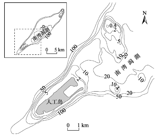 新窗口打开|下载原图ZIP|生成PPT
图1永暑礁地形[31]
注:等值线为海水等深线(m)。
Fig. 1Topography of Yongshu Reef with bathymetric contours
珊瑚礁的二元地质结构在世界范围内具有普遍性,其形成与第四纪以来的气候变化和海平面升降有关。末次冰期时海平面下降,珊瑚礁暴露在海平面以上接受降雨淋滤和风浪侵蚀作用,全新世以来,海平面上升,珊瑚礁继续增长,沉积了10~20 m厚的松散未胶结的碎屑沉积层,侵蚀面以下为更新世及以前经历成岩作用胶结较好的礁灰岩,形成上土下岩的二元地质结构[32]。礁灰岩岩体结构保留了原生生物骨架中的孔隙,并且在礁体暴露时期经受喀斯特化作用,溶蚀孔洞发育,具有孔隙率高,渗透性大的特点[33]。这种珊瑚礁的二元地质结构造成全新世松散沉积物和礁灰岩存在显著的渗透性差异,对于人工岛淡水透镜体的形成过程有着重要影响。
根据1990年中国科学院南沙综合科学考察队在永暑礁西南礁坪实施的“南永1井”钻孔,珊瑚礁全新世碎屑松散沉积物厚度17.3 m,为未胶结的珊瑚砾块和生物砾砂屑,以下为更新世礁灰岩[34](图2)。全新世地层也存在分层现象,造成含水层渗透性存在明显的各向异性。人工岛建于西南礁坪,用珊瑚砂填筑沙岛,填筑高度约为3 m。人工岛礁吹填过程中,颗粒自重对钙质珊瑚砂不同粒径颗粒起到分选作用,每次吹填过程形成表层一定厚度的低渗透性的粉土层,多次间断进行的吹填作业便造成了多层粉土层呈间断分层[35]。人工岛浅层钙质珊瑚砂的垂向分层结构和细颗粒粉土层对淡水透镜体形成具有重要影响,人工岛特殊的土层结构是人工岛礁淡水透镜体形成机制的重要研究方面。
图2
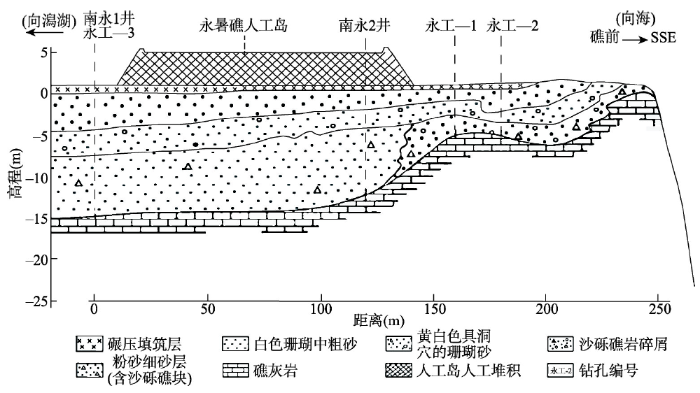 新窗口打开|下载原图ZIP|生成PPT
图2永暑礁西南礁坪浅层结构示意图[1, 36]
Fig. 2Schematic diagram of geological structure of the shallow layers in southwest reef flat of the Yongshu Reef
3 珊瑚礁淡水透镜体形成数值模拟
3.1 变密度水流数学模型
珊瑚岛淡水透镜体的形成实质上是降雨入渗后,由于岛屿和海平面间的地势差,入渗淡水在重力作用下驱替珊瑚礁中原有内渗海水的过程,淡水和海水之间的边界由于扩散作用是一个有一定宽度的咸淡水过渡带,过渡带内地下水盐分浓度随淡水向海水过渡深度增加而增大。因此,淡水透镜体形成过程的模拟需要考虑礁内水体密度变化。采用SEAWAT软件建立三维变密度流模型,SEAWAT耦合了MODFLOW和MT3DMS软件,分别用于变密度流运动和溶质运移微分方程的求解。人工岛淡水透镜体形成模拟采用三维变密度流模拟,当渗透系数张量主方向与坐标轴方向一致时,变密度流运动微分方程为:
式中:h为淡水相应的地下水头(L);ρ为地下水密度(M/L3);μ为地下水粘度(M/(L·T));μ0为淡水粘度(M/(L·T))ρ0为淡水密度(M/L3);Ki为渗透系数张量在x, y, z方向的分量(Kx, Ky, Kz; L/T);Ss为贮水率(1/L);θ为有效孔隙度;C为地下水盐分浓度(M/L3);t为时间(T);qs为源汇项(1/T);ρs为源汇项流体密度(M/L3);i = 1, 2, 3,对应于x, y, z坐标。
溶质运移微分方程为:
式中:ρb为含水层介质干密度(M/L3);Kd为吸附常数(L3/M);Dii为弥散系数张量分量;q为达西流速(L/T),Cs为源汇项浓度(M/L3);其他符号意义同上式。
3.2 模型范围及时空离散
模型模拟范围在礁缘向海外延500~1000 m,水平方向将第二级浅水平台包含在内。模型空间坐标系x轴与礁顶长轴NEE-SWW方向一致,西南近礁缘边界至东北澙湖边界间模型长4.2 km,y轴与礁顶短轴NW-SE方向一致,模型宽1.6 km,模型平面面积为6.72 km2,平面上等间距剖分为32行,84列,网格大小为50 m×50 m(图3)。垂向上从人工岛地平面向下延伸至海平面以下50 m,垂向上剖分为51列,海平面以上人工岛部分剖分为1层,以下剖分为50层。模型模拟50年内淡水透镜体的形成过程。图3
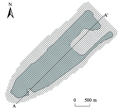 新窗口打开|下载原图ZIP|生成PPT
图3人工岛模型网格与剖面线位置
Fig. 3Model grid and location of the cross section
3.3 边界条件及模型参数
模型中顶部边界人工岛范围内接受降雨入渗补给,根据永暑礁海洋观测站降雨观测资料,1989—2000年多年平均降雨量1940 mm。太平洋珊瑚岛地下水补给量由于植被覆盖度不同,一般为降雨量的30%~60% [37],考虑到永暑礁人工岛建岛初期植被覆盖低,补给量按照降雨量的50%计算,即0.97 m/a。顶部边界人工岛以外部分以及模型周边侧向边界均处理成定水头(0 m,按海水计)和定浓度边界(TDS浓度35 g/L)。模型底部边界处理成隔水边界。永暑礁珊瑚砂孔隙体积与固体颗粒体积之比,即孔隙比范围在0.75~1.26之间[38],但珊瑚砂的孔隙由颗粒间的外孔隙和颗粒本身的内孔隙两部分组成。本文中取珊瑚砂孔隙度为0.44。根据太平洋中珊瑚岛含水层贮水参数和弥散参数研究[6, 37],含水层贮水率取0.0001(1/m),纵向弥散度取1 m,横向和垂向弥散度均取0.01 m。珊瑚岛含水层弥散参数通常采用数值模型识别方法得到,但永暑礁现有监测数据尚不足以用于模型参数识别,本研究重点分析珊瑚礁二元地质结构的渗透性对淡水透镜体的影响。
4 全新世珊瑚碎屑沉积物及更新世礁灰岩渗透性
4.1 全新世珊瑚碎屑沉积物渗透性
珊瑚礁全新世松散沉积物的渗透性通常与环礁所在地的盛行风向有关,环礁迎风向通常沉积较粗的沉积物,渗透性较大,反之在背风向易沉积较细的沉积物,渗透性较差。并且在岛内部存在渗透性差异,澙湖一侧沉积物较海洋一侧往往颗粒较细,渗透性较低。这种全新世沉积物在岛内部的渗透性差异甚至可以达到两个数量级,造成淡水透镜体形态上明显不对称[6]。国外文献中全新世珊瑚的水平向渗透系数一般为10~100 m/d量级[6]。中国以往对珊瑚砂的研究集中在其工程性质上,近年来开始对其渗透性质进行研究,主要采用实验室测定和原位抽水实验方法获得渗透系数,尚未有岛内部珊瑚砂渗透性明显变化的报道(表1)。Tab. 1
表1
表1珊瑚砂渗透系数实验成果表
Tab. 1
| 测定方法 | 试样个数/实验组数 | 渗透系数范围(m/d) | 渗透系数平均值(m/d) | 数据来源 | |
|---|---|---|---|---|---|
| 室内实验 | 常水头渗透实验 | 7 | 535.3~1334.1 | 706.6 | [39] |
| 常水头渗透实验 | 5 | 0.3~1.5 | 0.9 | [22] | |
| 常水头渗透实验 | 1 | 1023.8 | [19] | ||
| 常水头渗透实验 | 1 | 58.6 | [17] | ||
| 原位实验 | 双环渗透实验 | 12 | 1.0~52.0 | [21] | |
| 多孔稳定流抽水实验 | 3 | 0.7~1.6 | 1.1 | [20] | |
| 多孔稳定流抽水实验 | 4 | 103.1~114.4 | 110.0 | [16] | |
新窗口打开|下载CSV
珊瑚砂的渗透性与颗粒粗细、形状和分选性有关。实验室测定过程中主要分析珊瑚砂颗粒级配与渗透性的关系,一般首先对珊瑚砂进行筛分后,绘制颗粒级配曲线,从级配曲线读取珊瑚砂的有效粒径,并计算级配曲线的不均匀系数和曲率系数。珊瑚砂渗透系数一般与孔隙比、曲率系数、不均匀系数和有效粒径的二次方有很好的相关性,前人据此已建立多个经验公式,使用不均匀系数、曲率系数和有效粒径计算渗透系数[21,22]。前人利用室内渗透实验获取的南沙人工岛礁填筑用珊瑚砂的渗透系数差异较大,这可能与珊瑚砂中细颗粒粒径和含量有关。珊瑚砂中细颗粒对渗透性影响实验表明,当最小粒径≤ 0.075 mm时,渗透系数量级为10-2 cm/s(10 m/d量级);当最小粒径介于0.075~0.5 mm时,渗透系数量级为10-1 cm/s(100 m/d量级)[17]。当细颗粒含量较小时,其在水力渗透作用下挣脱束缚而发生运移、丢失,使土体结构重组,渗透系数一般呈缓慢增大后趋于稳定的变化特征[17]。
珊瑚礁原位抽水实验工作较少,新建人工岛浅层抽水实验测得的渗透系数在1 m/d量级,而天然的成岛历史久远的永兴岛浅层抽水实验测定渗透系数在100 m/d量级。室内实验和原位实验测定的珊瑚砂渗透系数差异较大,说明珊瑚砂渗透性与当地地层结构特征有关,人工岛珊瑚砂渗透性可能随雨水入渗淡化过程发生变化。因此,预测某具体人工岛能够形成的淡水透镜体规模时,有必要对珊瑚砂渗透性的影响进行定量分析。
4.2 更新世礁灰岩渗透性
前人对珊瑚岛淡水透镜的模拟研究中,礁灰岩的渗透系数多采用500~1000 m/d [6],并且一般采用经验值直接用于模型或者通过模型校正确定礁灰岩渗透系数取值。但对于新建人工岛,已有监测数据尚不足以用于模型的校正和参数识别。因此,需要有礁灰岩渗透性的实测成果用于人工岛淡水透镜体的模拟预测。中国目前在海底油气藏研究中,对礁灰岩渗透性进行了一定研究,确定礁灰岩储层渗透性的方法主要包括室内岩芯测定法、测井法和地震反演法,这3种方法测定的渗透率反映的孔隙介质的流体渗流性质,或者为孔隙渗透率[40]。对于孔隙、裂隙和溶洞可能并存的礁灰岩,上述3种方法测定的渗透率都不能反映礁灰岩的真实渗透率。中国南海流花11-1油田礁灰岩储层渗透性研究表明,礁灰岩渗透率在1~10 μm2范围[40]。本文建立32个系列模型,分别针对更新世礁灰岩渗透系数(KHP)在500 m/d和1000 m/d尺度下,全新世沉积物渗透系数(KHH)在5~500 m/d范围内的量级变化对淡水透镜体(地下水总溶解固体浓度,TDS ≤ 1 g/L)的影响。垂向渗透系数按照水平渗透系数的1/5取值。
5 人工岛礁淡水透镜体形成控制因素
5.1 含水层渗透性对淡水透镜体形成时间影响
全新世珊瑚砂和更新世礁灰岩不同渗透系数组合情况下的淡水透镜体开始形成时间、最大厚度和体积如表2所示。人工岛淡水透镜体的形成是一个随时间逐渐增大直至稳定,淡水体与周围海水逐渐平衡的过程(图4)。全新世珊瑚碎屑沉积物渗透系数对开始出现淡水体的时间影响不大,填岛完成2年左右即可观测到淡水,形成微小的淡水透镜体(图4)。人工岛淡水体形成初期,淡水体的形成主要与地下水补给这一外部驱动力有关。太平洋中珊瑚岛遭受风暴潮淹没后的淡水透镜体的恢复过程的监测和模拟研究发现,海水淹没对珊瑚礁淡水透镜体的破坏是暂时的,淡水透镜体能够在6~17个月时间恢复[41,42],说明珊瑚岛淡水透镜体的形成时间很快。永暑礁人工岛吹填工程2015年基本完毕,经过2年左右降雨淋滤,2017年地下水氯离子浓度监测显示在珊瑚礁体中心浅层位置已形成圆台型淡水体[20]。模型模拟的淡水透镜体开始形成时间与南海人工岛礁地下水盐分变化监测结果基本一致。人工岛淡水透镜体形成时间较大陆含水层浅层潜水补给更新时间尺度非常短暂。这说明人工岛淡水透镜体在合理开发利用下,对保证人工岛生活和生态用水具有重要意义的。Tab. 2
表2
表2全新世珊瑚砂和更新世礁灰岩不同渗透系数组合下淡水透镜体形成时间和体积
Tab. 2
| 全新世珊瑚砂渗透系数(KHH)(m/d) | 更新世礁灰岩渗透系数(KHP)为500 m/d | 更新世礁灰岩渗透系数(KHP)为1000 m/d | |||||
|---|---|---|---|---|---|---|---|
| 淡水透镜体开始形成时间(a) | 淡水透镜体最大厚度(m) | 淡水透镜体体积(万m3) | 淡水透镜体开始形成时间(a) | 淡水透镜体最大厚度(m) | 淡水透镜体体积(万m3) | ||
| 5 | 1.64 | 22.5 | 4774.75 | 1.72 | 19.5 | 4463.25 | |
| 10 | 1.47 | 22.5 | 3969.25 | 1.84 | 20.5 | 3103.5 | |
| 20 | 1.7 | 20.5 | 2850.25 | 1.75 | 19.5 | 2670.75 | |
| 30 | 1.54 | 21.5 | 2492.25 | 1.64 | 19.5 | 2378.75 | |
| 40 | 1.52 | 20.5 | 2257.25 | 1.53 | 19.5 | 2134 | |
| 50 | 1.51 | 20.5 | 2081.5 | 1.53 | 18.5 | 1964.5 | |
| 60 | 1.51 | 20.5 | 1963 | 1.52 | 18.5 | 1829.75 | |
| 70 | 1.47 | 19.5 | 1835.5 | 1.48 | 18.5 | 1769.75 | |
| 80 | 1.49 | 19.5 | 1715.25 | 1.49 | 19.5 | 1699.75 | |
| 90 | 1.46 | 18.5 | 1599 | 1.46 | 18.5 | 1587.75 | |
| 100 | 1.43 | 17.5 | 1502.25 | 1.43 | 17.5 | 1487.25 | |
| 150 | 1.44 | 14.5 | 1148.75 | 1.43 | 14.5 | 1137.75 | |
| 200 | 1.42 | 12.5 | 958 | 1.45 | 12.5 | 945.75 | |
| 300 | 1.43 | 8.5 | 633.5 | 1.4 | 7.5 | 554.75 | |
| 400 | 1.43 | 6.5 | 387.75 | 1.43 | 6.5 | 389.25 | |
| 500 | 1.45 | 4.5 | 194.5 | 1.42 | 5.5 | 179.5 | |
新窗口打开|下载CSV
图4
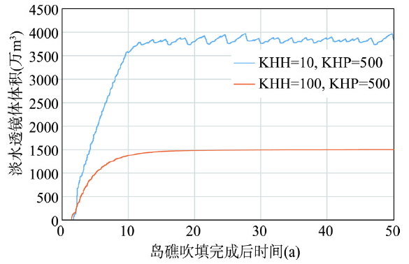 新窗口打开|下载原图ZIP|生成PPT
图4淡水透镜体体积随时间变化规律
Fig. 4Variation of fresh groundwater volume with time
5.2 含水层渗透性对淡水透镜体形成体积影响
淡水透镜体最大厚度随全新世珊瑚碎屑沉积物渗透系数增大呈指数衰减(图5),与前人研究发现规律一致[16]。永暑礁全新世碎屑松散沉积物与更新世礁灰岩不整合面深度为17.3 m,当全新世珊瑚砂渗透系数小于100 m/d时,淡水透镜体最大深度越过不整合面进入礁灰岩。当淡水透镜体进入礁灰岩后,礁灰岩渗透系数增大同样造成淡水透镜体体积一定程度的减小(表2)。当全新世珊瑚砂渗透系数大于100 m/d时,礁灰岩渗透性对淡水透镜体的最大厚度和体积无显著影响。图5
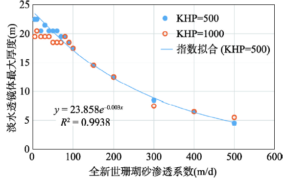 新窗口打开|下载原图ZIP|生成PPT
图5淡水透镜体最大厚度随全新世珊瑚砂渗透系数变化
Fig. 5Variation of calculated maximum thickness of fresh groundwater lens with hydraulic conductivities of Holocene sediments
模拟各情景中,淡水透镜体进入礁灰岩深度不超过2 m(表2),礁灰岩渗透性对淡水透镜体体积影响作用有限,说明南海珊瑚礁二元地质结构中,对淡水透镜体起控制作用的是全新世珊瑚砂的渗透性。
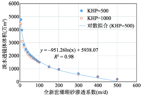
相比淡水透镜体最大厚度随渗透系数衰减,淡水透镜体形成体积随渗透系数的衰减更加显著。淡水透镜体形成体积随全新世珊瑚碎屑沉积物渗透系数增大呈对数衰减(即渗透系数取对数后,呈线性衰减趋势)(图6)。若以永兴岛浅层抽水实验测定渗透系数(100 m/d量级)为基准,能够形成的淡水透镜体体积在1500万m3左右,这对于人工岛生活用水保障和生态岛屿建设有重要意义。
图6
 新窗口打开|下载原图ZIP|生成PPT
图6淡水透镜体体积随全新世珊瑚砂渗透系数变化
Fig. 6Variation of calculated volume of fresh groundwater with hydraulic conductivities of Holocene sediments
5.3 珊瑚礁二元地质结构对淡水透镜体形态影响
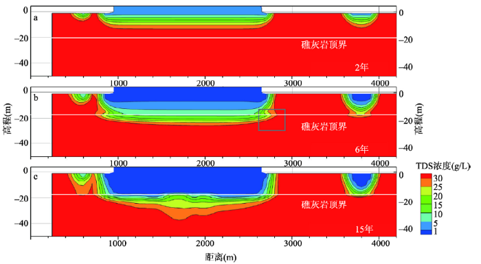
虽然岛礁的二元地质结构中全新世珊瑚砂对淡水透镜体最终能够形成的体积起控制作用,但当全新世珊瑚砂渗透系数在10 m/d量级以下时,淡水透镜体的最大深度浓度均超过了全新世珊瑚砂和更新世礁灰岩的不整合面,更新世礁灰岩对淡水透镜体的形成过程会造成影响。当淡水透镜体的咸淡水界面越过不整合面进入更新世礁灰岩后,由于含水层渗透系数突然增大,淡水透镜体的咸淡水界面向水平向扩展,形如“髭”状[43](图7)。珊瑚礁二元地质结构不仅造成最终形成的淡水透镜体在不整合面发生尖灭,对于淡水透镜体的动态演化过程也有重要影响。图7
 新窗口打开|下载原图ZIP|生成PPT
图7沿A-A'剖面不同时间淡水透镜体分布特征
Fig. 7Spatial distribution of salinity concentration along cross section A-A' at selected times during the formation process of the fresh groundwater lens.
永暑礁人工岛氯离子浓度监测显示当入渗淡水进入渗透性较大地层后向水平向扩展,形成“帽沿状”淡水体[20]。人工岛氯离子监测虽然目前仍限于全新世松散沉积物,但渗透性的分层差异对淡水透镜体形成过程的影响观测和模拟结果是一致的。淡水体在人工岛下部主要沿垂向向下扩展,进入礁灰岩顶界后沿水平向有所扩大,但这种水平向的扩展距离应该是有限的。
模拟结果和盐分浓度监测说明不仅珊瑚礁上土下岩的地质结构分层对淡水透镜体的形成过程和形态有重要影响,全新世沉积物和人工岛吹填土层的分层同样对淡水透镜体有重要影响。当考虑含水层存在内部分层造成的渗透性各向异性时,淡水透镜体的形成过程会更加复杂。
6 讨论及结论
对南海珊瑚礁人工岛淡水透镜体的模拟预测是在目前认识和资料条件下的、针对珊瑚礁普遍存在的二元地质结构,建立了珊瑚礁人工岛淡水驱替海水形成淡水透镜体的动态模拟模型,系统分析了地层渗透性对淡水透镜体体积的影响,给出了人工岛礁淡水形成时间和淡水透镜体可能形成的体积规模,根据珊瑚礁二元地质结构不同渗透系数组合下淡水驱替海水的非稳态模拟结果,得出如下结论:(1)人工岛礁二元地质结构、上层全新世沉积物和下层礁灰岩渗透性对淡水开始形成时间无明显影响,人工岛填岛完成2年左右可观测到淡水,在10~20年内可形成相对稳定的淡水透镜体。由于南海珊瑚礁热带气候下的强降雨量,人工岛淡水透镜体的形成时间较大陆含水层地下水的补给更新时间尺度是非常短暂的,其对人工岛生活和生态用水是有重要保证意义的。
(2)全新世沉积物渗透性是控制人工岛礁淡水透镜体体积的主要因素,能够形成的淡水透镜体最大体积随渗透系数增大而呈对数减小,并且淡水透镜体体积随全新世沉积物渗透性增大而减小的速率较淡水透镜体厚度更加显著。渗透系数小于100 m/d时,淡水透镜体最大深度将越过不整合面,但进入礁灰岩深度有限(< 2 m),淡水透镜体的体积进而受礁灰岩渗透性影响,随礁灰岩渗透系数增大而减小。基于数值模型对人工岛淡水透镜体形成体积的可靠预测,一方面需要对含水层渗透性空间分布进行深入调查,另一方面也需要对地下水盐分浓度进行详细观测,能够利用其对模型参数进行针对性校正。
(3)淡水透镜体越过不整合面进入更新世礁灰岩顶界后,由于含水层渗透系数突然增大,淡水透镜体咸淡水界面向水平向扩展,形成“髭”状淡水体。人工岛地层的渗透性分层差异对淡水透镜体形成过程的影响值得深入研究,关键在于对珊瑚砂含水层垂向渗透系数沿深度变化的详细准确刻画。
参考文献 原文顺序
文献年度倒序
文中引用次数倒序
被引期刊影响因子
DOI:10.13284/j.cnki.rddl.002974URL [本文引用: 3]

Artificial islands construction has long history in China and other coastal countries, but artificial islands construction on coral reefs are very different because of the special geological landforms and sediments. The concept, development and trends of the construction of artificial islands are reviewed and the general situation of coral reefs in the South China Sea is introduced. The South China Sea Islands lies to the east and south of Hainan Island and is rich for abundant tropical marine resources, such as territorial resources, marine petroleum and gas resources, tourism resources, harbor and channel resources. Its geopolitics is complex and the strategic positions special. The South China Sea Islands has 62 drying reefs and 49 lime-sand islands which is theoretically suitable for the construction of artificial islands. In the past 40 years, several neighboring countries have forcibly occupied some islands and reefs of the Nansha Islands, illegally reclaimed lands and built military structures, and extensively explored in adjacent waters to plunder marine petroleum and gas resources. And now the South China Sea Islands faces the same and more serious political situation and it needs rapid and effective respond. The geological and topographical conditions suitable for the exploitation and construction on coral reefs in the South China Sea Islands are analyzed, such as shoals, islets, and drying reefs. The ecological environment conditions affecting the land reclaimed are also evaluated from the view of coral reef facies, which include the impacts of the exploitation and construction on the coral reef ecosystem and those of the resultant hydrodynamic changes in the coral reef landforms. The built and under-building artificial islands are given as examples. An emphasis on planning and site selection for the land reclamation on the coral reefs in the South China Sea Islands is proposed and the technical idea of “natural simulation” for engineering construction and for future sustainable development is produced.
DOI:10.13284/j.cnki.rddl.002974URL [本文引用: 3]
Artificial islands construction has long history in China and other coastal countries, but artificial islands construction on coral reefs are very different because of the special geological landforms and sediments. The concept, development and trends of the construction of artificial islands are reviewed and the general situation of coral reefs in the South China Sea is introduced. The South China Sea Islands lies to the east and south of Hainan Island and is rich for abundant tropical marine resources, such as territorial resources, marine petroleum and gas resources, tourism resources, harbor and channel resources. Its geopolitics is complex and the strategic positions special. The South China Sea Islands has 62 drying reefs and 49 lime-sand islands which is theoretically suitable for the construction of artificial islands. In the past 40 years, several neighboring countries have forcibly occupied some islands and reefs of the Nansha Islands, illegally reclaimed lands and built military structures, and extensively explored in adjacent waters to plunder marine petroleum and gas resources. And now the South China Sea Islands faces the same and more serious political situation and it needs rapid and effective respond. The geological and topographical conditions suitable for the exploitation and construction on coral reefs in the South China Sea Islands are analyzed, such as shoals, islets, and drying reefs. The ecological environment conditions affecting the land reclaimed are also evaluated from the view of coral reef facies, which include the impacts of the exploitation and construction on the coral reef ecosystem and those of the resultant hydrodynamic changes in the coral reef landforms. The built and under-building artificial islands are given as examples. An emphasis on planning and site selection for the land reclamation on the coral reefs in the South China Sea Islands is proposed and the technical idea of “natural simulation” for engineering construction and for future sustainable development is produced.
DOI:10.3969.issn.0253-4193.2014.09.013URL [本文引用: 1]
Darwin firstly developed the coral reef morphological type and discussed its genetic mechanism, after he performed a global survey for coral reefs in tropical oceans during 1832 to 1836. The overall morphology of coral reef in his model looks like a wholly or partly truncated cone-shape, which is called as "the truncated taper" type in this paper. Subsequent several-generation researchers accepted his model. In recent time some workers have put forward another type for coral reefs after studying on geomorphologic characteristics of coral reefs in the South China Sea (SCS). In this new model, the outer reef slope takes on a concave curve and the reef’s shape is mushroom-like, and the model is called as mushroom-like type in this paper. Based on the measured data and references in geomorphology, we confirmed that the morphological type of coral reefs in the SCS is not the mushroom-like type but the truncated cone-shape, because the former one didn’t match the rules for the formation and evolution of coral reefs in nature.
URL [本文引用: 2]
Freshwater lens is an important groundwater resource in coral reef islands, and is essential to meet people’s needs and maintain the ecosystem of the island. In this paper, researches on the freshwater lens in the coral reef island are reviewed, including its theory and characteristics. Some factors related to the development of the freshwater lens are summarized, such as, those of hydrogeology, climate, tide, topography and vegetation of the island. The threats from natural and human activities are more serious to freshwater lens than before and need more attention, for example, drought, seawater intrusion, sea-level rising, mechanic erosion of the island, over-drawing of fresh water, pollution, the changes of the landform and coastal construction, etc. may cause damages on freshwater lens. In this paper, some models used in the study of the freshwater lens are described, such as physical models, analytical models and numerical models. The study of the freshwater lens in China is also introduced. Most researches are focused on Yongxing Island of the Xisha Islands. The study contents involve the thickness of the freshwater lens, its changes with rain, the up-coning of the interface caused by withdrawing of the groundwater, and bioremediation of the freshwater lens. Finally, prospect for the study of the fresh-water lens in coral reef islands is given in the paper. It is suggested that more islands in the South China Sea should be studied, and techniques to clean the pollution of groundwater and make the water drinkable should be developed.
[本文引用: 2]
[本文引用: 2]
[D].
[本文引用: 2]
[D].
[本文引用: 2]
DOI:10.1016/j.jhydrol.2017.02.047URL [本文引用: 6]
[本文引用: 3]
[本文引用: 3]
[本文引用: 1]
[本文引用: 1]
[本文引用: 1]
[本文引用: 1]
[本文引用: 1]
[本文引用: 1]
[D].
[本文引用: 1]
[D].
[本文引用: 1]
[本文引用: 1]
[本文引用: 1]
[D].
[本文引用: 1]
[D].
[本文引用: 1]
[本文引用: 2]
[本文引用: 2]
URL [本文引用: 1]
URL [本文引用: 1]
[本文引用: 2]
[本文引用: 2]
[本文引用: 3]
[本文引用: 3]
[D].
[本文引用: 1]
[D].
[本文引用: 1]
[本文引用: 1]
[本文引用: 1]
[D].
[本文引用: 3]
[D].
[本文引用: 3]
[本文引用: 2]
[本文引用: 2]
[本文引用: 2]
[本文引用: 2]
[D].
[本文引用: 1]
[D].
[本文引用: 1]
[本文引用: 1]
[本文引用: 1]
[本文引用: 1]
[本文引用: 1]
DOI:10.1029/92WR01723URL [本文引用: 1]
[本文引用: 1]
[本文引用: 1]
[本文引用: 2]
[本文引用: 2]
DOI:10.11821/dlxb201603013URL [本文引用: 1]
Professor Zeng Zhaoxuan was an outstanding geographer. He published numerous articles in various fields of geography, including geomorphology, physical geography and historical geography. Based on long-term field surveys, he studied coastal geomorphology and coral reef geomorphology of the South China Sea, and divided the coast of China into mountainous coast, platform coast and plain coast. In the book China's Coral Reef Geomorphology Research, he and the coauthors Liang Jingfen, et al., systematically reviewed the history of coral reef detection and the species, ecology, geomorphic features and growth of Scleractinia, and divided coral reefs of China into four major areas as well as six geomorphic types. He believed that Genglubu might date back to the Song Dynasty, but the existing version mainly came from the Ming Dynasty. He perfected the classification of folk place name of coral reef geomorphology, divided the distribution area of coral reefs in the South China Sea and drew coral reef detecting map according to Genglubu. From the geological and geomorphological perspectives, he not only demonstrated continental margin relations between the Chinese mainland and the South China Sea Islands, but also showed the evidence that South China Sea is China's inherent territory using the data of historical geography and local chronicles.
[本文引用: 1]
[本文引用: 1]
[本文引用: 1]
[本文引用: 1]
DOI:10.12677/AG.2019.92008URL [本文引用: 1]
DOI:10.12677/AG.2019.92008URL [本文引用: 1]
[本文引用: 1]
[本文引用: 1]
[本文引用: 1]
[本文引用: 1]
[本文引用: 1]
[本文引用: 1]
[本文引用: 1]
[本文引用: 1]
DOI:10.1016/j.jhydrol.2018.06.015URL [本文引用: 2]
[本文引用: 1]
[本文引用: 1]
[本文引用: 2]
[本文引用: 2]
DOI:10.1007/s10040-009-0544-xURL [本文引用: 1]
A category 5 tropical cyclone swept a storm surge across remote Pukapuka Atoll in the Northern Cook Islands (South Pacific Ocean) in late February 2005. Groundwater salinity (specific conductance) observations are reported for the 2-year post-storm period, with the aim of investigating the effects of saltwater intrusion on thin freshwater lenses within the atoll islets. This is the first article to present field observations of such an event. Specific conductance at shallow depths increased dramatically from potable conditions (approximately 1,000 μS/cm) to brackish levels unsuitable for drinking (up to 10,000 μS/cm) shortly after the cyclone. Subsequently, the freshwater lenses required 11 months to recover. Within the thickest aquifer, a well-defined saline plume formed at 6 m depth, sandwiching a freshwater layer beneath it and the base of the lens. Plume dispersal proceeded only gradually, owing to its formation at the start of the SW Pacific regional dry season and the low tidal range on Pukapuka. Consequently, the remnant of the plume was still present 26 months after the saltwater incursion. An important finding was that the freshwater horizon preserved at depth maintained salinity levels below 1,800 μS/cm (i.e. within usable limits) for at least 5 months after surface overwash.
DOI:10.1002/hyp.v29.20URL [本文引用: 1]
DOI:10.1016/j.jhydrol.2015.07.019URL [本文引用: 1]
