姜柏志1,
刘国辉2,
张慧3,
聂凡1,
孙琦1,
纪明元1
1.东北农业大学资源与环境学院 哈尔滨 150030
2.黑龙江省农业环境与耕地保护站 哈尔滨 150000
3.东北农业大学公共管理与法学院 哈尔滨 150030
基金项目: 国家重点研发计划项目2017YFD0300500
详细信息
通讯作者:张迪, 主要从事土壤地球化学调查与评价研究。E-mail: zhangdi6283@neau.edu.cn
中图分类号:S159.2计量
文章访问数:145
HTML全文浏览量:35
PDF下载量:25
被引次数:0
出版历程
收稿日期:2020-12-02
录用日期:2021-03-05
刊出日期:2021-08-01
Applicability of spatial interpolation methods to predict total phosphorus in the typical irrigated areas of the Sanjiang Plain
ZHANG Di1,,,JIANG Baizhi1,
LIU Guohui2,
ZHANG Hui3,
NIE Fan1,
SUN Qi1,
JI Mingyuan1
1. College of Resources and Environment, Northeast Agricultural University, Harbin 150030, China
2. Heilongjiang Agricultural Environment and Cultivated Land Protection Station, Harbin 150000, China
3. College of Public Administration and Law, Northeast Agricultural University, Harbin 150030, China
Funds: the National Key Research and Development Project of China2017YFD0300500
More Information
Corresponding author:ZHANG Di, E-mail: zhangdi6283@neau.edu.cn
摘要
HTML全文
图
参考文献
相关文章
施引文献
资源附件
访问统计
摘要
摘要:土壤磷素含量是反映农业生态系统土壤肥力的重要指标。准确预测磷素空间异质性是评价土壤生产力和质量的关键。本研究采用反距离加权法(IDW)、径向基函数法(RBF)、普通克里金法(OK)、全局多项式法(GPI)、局部多项式法(LPI)、地理加权回归(GWR)和地理加权回归克里金法(GWRK)等插值方法,分别预测了三江平原白浆土典型灌区八五三、七里沁以及大兴灌区土壤磷素分布,并运用交叉验证法,通过平均误差(ME)、均方根误差(RMSE)和改进效果(RI)对各种方法精度进行比较,以期确定同一土壤类型不同采样密度土壤中磷素空间异质性最佳插值方法。对比7种插值方法,在空间插值平滑性方面,LPI、GPI、GWR、GWRK表现较好,在插值速度方面,IDW、RBF、LPI、GPI、OK较快,GWR和GWRK方法运算复杂、速度较慢。IDW、RBF等6种方法与OK相比,根据RI判定,GWRK方法提高了磷素空间分布模拟精度,IDW、GPI和LPI方法降低了磷素空间分布模拟精度,RBF方法在提高磷素空间分布模拟精度上表现不一致。采样密度会影响预测结果,对于本文而言,不论采样密度如何,GWRK方法均方根误差(RMSE)均最低,为最佳插值方法,而RBF方法是在采样密度较低时一种可选方法。GWRK法在本文是最佳的插值方法,但其结果会受到辅助变量多少和各变量之间是否存在共线性的影响。
关键词:白浆土/
磷素/
插值方法/
交叉验证/
空间自相关性/
适用性
Abstract:In the late 1990s, the "Dryland to Paddy" project was implemented in the Sanjiang Plain. After planting rice in the Albic soil, the barrier soil layer turns into a favorable soil layer, the low-yield soil becomes high-yield soil, and the Albic soil phosphorus pool increases. After flooding, the availability of phosphorus (closed storage phosphorus[O-P] and iron-bound phosphorus[Fe-P]) increases with the decrease in soil redox potential (Eh) and the increase in pH, which substantially affects soil phosphorus heterogeneity. Therefore, we urgently need an optimal interpolation method to improve the prediction accuracy of total phosphorus in the Albic soil of typical irrigation areas of the Sanjiang Plain. This will help evaluate the impact of climate change and land use on the soil phosphorus pools and provide a reference for estimating future soil phosphorus pools. This study used the inverse distance weighting (IDW) method, radial basis function (RBF), ordinary Kriging (OK), global polynomial method (GPI), local polynomial method (LPI), geographic weighted regression (GWR), and geographic weighting regression to Kriging (GWRK) to predict the distribution of soil phosphorus in the Bawusan, Qiliqin, and Daxing irrigation areas of the Sanjiang Plain. The cross-validation method was used to obtain the mean error (ME), root mean square error (RMSE), and relative improvement (RI) to compare the accuracies of the various methods to determine the best interpolation method for assessing the spatial heterogeneity of phosphorus in the same soil type with different sampling densities. Based on the assumptions of regression analysis, this study incorporated 24 environmental variables for exploratory regression analysis, including elevation, pH, organic matter, exchangeable sodium, total nitrogen, available phosphorus, available copper, cultivated layer bulk density, and rice yield. According to the regression results, the auxiliary variables that were significantly correlated with phosphorus were selected for least square analysis. Finally, exchangeable sodium, cation exchange capacity, and available phosphorus were selected as auxiliary variables for the Bawusan irrigation area; organic matter, available zinc, and available boron were selected as auxiliary variables for the Qiliqin irrigation area; and cation exchange capacity, available zinc and copper were selected as auxiliary variables for the Daxing irrigation area. Compared to OK, RI indicated that the GWRK method with environmental auxiliary variables significantly improved the simulation accuracy of the spatial distribution of phosphorus. The IDW, GPI, and LPI methods reduced the accuracy of phosphorus spatial distribution simulation, whereas the RBF method was inconsistent. When comparing the mapping effect and interpolation speed of the seven interpolation methods, LPI, GPI, GWR, and GWRK had better mapping effects, whereas IDW, RBF, LPI, GPI, and OK were faster. The GWRK method had a better mapping effect, but it should be combined with environmental auxiliary variables, and the operation was complicated and slow. Sampling evenness also affected the prediction results. Nonetheless, GWRK had the lowest ME and RMSE, indicating that it is the best interpolation method. RBF is an optional method when the sampling evenness is lower. GWRK is the best interpolation method, but the results are affected by the number of auxiliary variables and collinearity between the variables.
Key words:Albic soil/
Phosphorus/
Interpolation method/
Cross validation/
Spatial autocorrelation/
Applicability
HTML全文
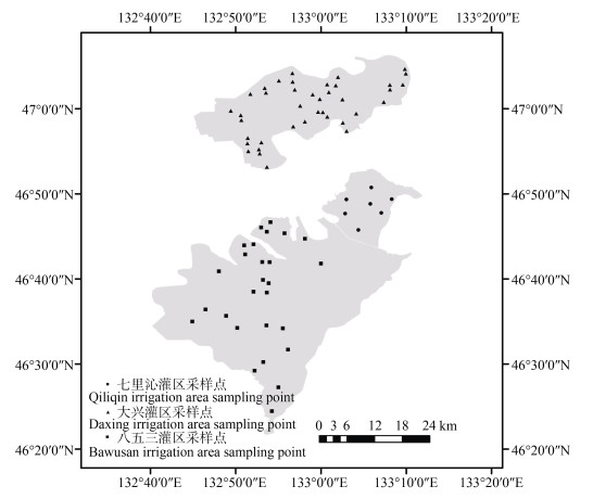
图1三江平原典型灌区的白浆土样点分布
Figure1.General situation and distribution of sample points in Albic soil area in the typical irrigation area of the Sanjiang Plain
 下载: 全尺寸图片幻灯片
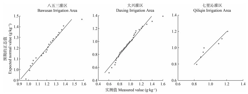
图2三江平原典型灌区白浆土磷素正态性分布检验
Figure2.Inspection of normal distribution of phosphorus in Albic soil in the typical irrigation areas of the Sanjiang Plain
下载: 全尺寸图片幻灯片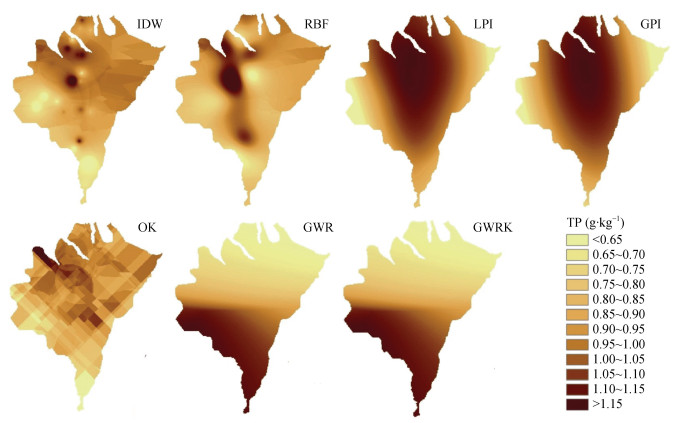
图3八五三灌区不同插值方法磷素(TP)空间分布预测
IDW: 反距离加权; RBF: 径向基函数; OK: 普通克里金; GPI: 全局多项式法; LPI: 局部多项式法; GWR: 地理加权回归; GWRK: 地理加权回归克里金法。
Figure3.Prediction of spatial distribution of phosphorus (TP) by different interpolation methods in Bawusan Irrigation Area
IDW: inverse distance weighting method; RBF: radial basis function; OK: ordinary Kriging; GPI: global polynomial method; LPI: local polynomial method; GWR: geographic weighted regression; GWRK: geographic weighting regression to Kriging.
下载: 全尺寸图片幻灯片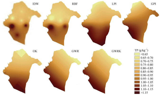
图4大兴灌区不同插值方法磷素(TP)空间分布预测
IDW: 反距离加权; RBF: 径向基函数; OK: 普通克里金; GPI: 全局多项式法; LPI: 局部多项式法; GWR: 地理加权回归; GWRK: 地理加权回归克里金法。
Figure4.Prediction of spatial distribution of phosphorus (TP) by different interpolation methods in Daxing Irrigation Area
IDW: inverse distance weighting method; RBF: radial basis function; OK: ordinary Kriging; GPI: global polynomial method; LPI: local polynomial method; GWR: geographic weighted regression; GWRK: geographic weighting regression to Kriging.
下载: 全尺寸图片幻灯片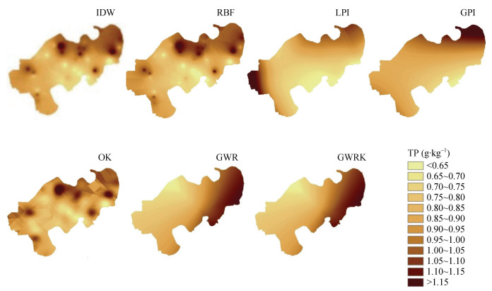
图5七里沁灌区不同插值方法磷素空间分布预测
IDW: 反距离加权; RBF: 径向基函数; OK: 普通克里金; GPI: 全局多项式法; LPI: 局部多项式法; GWR: 地理加权回归; GWRK: 地理加权回归克里金法。
Figure5.Prediction of spatial distribution of phosphorus by different interpolation methods in Qiliqin Irrigation Area
IDW: inverse distance weighting method; RBF: radial basis function; OK: ordinary Kriging; GPI: global polynomial method; LPI: local polynomial method; GWR: geographic weighted regression; GWRK: geographic weighting regression to Kriging.
下载: 全尺寸图片幻灯片表1研究区土壤概况
Table1.Soil profile in the typical irrigation area of the Sanjiang Plain
| 研究区 Research area | 面积 Area (km2) | 土类 Soil | 亚类 Subcategory | 成土母质 Parent material | ≥10 ℃积温 ≥10 ℃ accumulated temperature (℃) | 年降水量 Annual precipitation (mm) | 土壤侵蚀类 Soil erosion | 障碍层类型 Type of barrier |
| 八五三灌区 Bawusan Irrigation Area | 829.0639 | 白浆土 Albic soil | 典型白浆土 Typical Albic soil | 黄土状黏质土 Loess-like clay soil | 2487 | 565.0 | 混合侵蚀 Mixed erosion | 白浆层 Albic layer |
| 大兴灌区 Daxing Irrigation Area | 387.9494 | 白浆土 Albic soil | 潜育白浆土、 草甸白浆土 Gleed Albic soil, meadow Albic soil | 残积物 Residue | 2761 | 561.0 | 无侵蚀 No erosion | 无 Null |
| 七里沁灌区 Qiliqin Irrigation Area | 121.4848 | 白浆土 Albic soil | 潜育白浆土 Gleed Albic soil | 冲积物 Alluvial deposit | 2330 | 586.3 | 混合侵蚀 Mixed erosion | 无 Null |
下载: 导出CSV表2典型灌区白浆土采样点磷素含量分析
Table2.Phosphorus contents in sampling points of Albic soil in the typical irrigation areas
| 灌区 Irrigation area | 采样点数 Sampling points | 最小值 Min (g?kg–1) | 最大值 Max (g?kg–1) | 平均值 Average (g?kg–1) | 方差 Variance | 标准偏差 Standard deviation (g?kg–1) | 变异系数 Coefficient of variation | 峰度 Kurtosis | 偏度 Skewness | 采样密度 Sampling density (points?km–2) |
| 七里沁 Qiliqin | 7 | 0.83 | 1.21 | 1.00 | 0.0219 | 0.1480 | 0.1482 | –1.8930 | 0.4090 | 0.06 |
| 八五三 Bawusan | 27 | 0.97 | 1.58 | 1.19 | 0.0194 | 0.1392 | 0.1169 | 0.8357 | 0.6007 | 0.03 |
| 大兴 Daxing | 39 | 0.65 | 1.22 | 0.92 | 0.0194 | 0.1394 | 0.1514 | –0.8081 | –0.0064 | 0.10 |
下载: 导出CSV表3典型灌区白浆土辅助变量与磷素相关显著性分析
Table3.Significance analysis of the correlation between auxiliary variables and phosphorus of Albic soil in the typicalirrigation areas %
| 辅助变量 Auxiliary variable | 八五三灌区 Bawusan Irrigation Area | 七里沁灌区 Qiliqin Irrigation Area | 大兴灌区 Daxing Irrigation Area | 辅助变量 Auxiliary variable | 八五三灌区 Bawusan Irrigation Area | 七里沁灌区 Qiliqin Irrigation Area | 大兴灌区 Daxing Irrigation Area | |
| 土壤pH Soil pH | 50.67* | — | — | 土壤有效铜 Soil available cuprum | 2.26 | 3.15 | 82.61* | |
| 土壤交换性钠 Soil exchangeable sodium | 44.95* | 1.18 | 13.58* | 土壤速效钾 Soil available potassium | 1.88 | 0.79 | 0.14 | |
| 土壤全氮 Soil total nitrogen | 41.15* | 3.15 | 1.08 | 土壤锌 Soil zinc | 0.31 | 0.39 | 0.48 | |
| 土壤有效磷 Soil available phosphorus | 31.66* | 0.39 | 0.18 | 水稻产量 Rice yield | 0.25 | — | — | |
| 海拔 Altitude | 29.63* | — | — | 耕层容重 Cultivated layer bulk density | 0.14 | — | 2.04 | |
| 土壤有效硅 Soil available silicon | 24.23 | 0.39 | 72.41* | 土壤有效硼 Soil available boron | 0.14 | 1.18 | 0.05 | |
| 土壤镉 Soil cadmium | 22.51 | — | — | 土壤铜 Soil cuprum | 0.14 | 2.76 | — | |
| 土壤CEC Soil CEC | 20.20 | 2.36 | — | 土壤有效锌 Soil available zinc | 0.07 | 10.24* | 100.00* | |
| 土壤铬 Soil chromium | 7.96 | 26.38* | 0.07 | 土壤缓效钾 Soil slow potassium | 0.02 | — | 4.37 | |
| 土壤有效锰 Soil available manganese | 3.44 | 12.20* | — | 土壤全钾 Soil total potassium | 0.01 | 1.57 | 55.24 | |
| 土壤镍 Soil nickel | 2.75 | 1.18 | 2.45 | 土壤有效铁 Soil available iron | 0.01 | — | 1.07 | |
| 土壤铅 Soil plumbum | 2.30 | 7.87 | 28.74 | 土壤有机质 Soil organic matter | — | 3.15 | — | |
| 表中数据大小表示该变量作为预测因子的强度, 数值越大表明其作为预测因子趋势越大, *代表该辅助变量与磷元素具有显著相关性。Data in the table indicates the strength of the variable used as a predictor parameter, and the larger the data, the greater the trend as a predictor. “*” means that the auxiliary variable is significantly correlated with soil phosphorus content. | ||||||||
下载: 导出CSV表4典型灌区白浆土辅助变量与磷素多元线性逐步回归分析
Table4.Multiple linear stepwise regression analysis between auxiliary variables and phosphorus of Albic soil in the typical irrigation areas
| 灌区 Irrigation area | 变量 Variable | 系数 Coefficient | 标准差 Standard deviation | T统计量 T statistics | 概率 Probability | VIF值 VIF value |
| 八五三 Bawusan | 土壤交换性钠Soil exchangeable sodium | –1.8121 | 0.3927 | –4.6149 | 0.0001 | 1.4022 |
| 耕层容重Cultivated layer bulk density | –0.6753 | 0.2895 | –2.3329 | 0.0297 | 2.0655 | |
| 土壤CEC Soil CEC | 0.0141 | 0.0050 | 2.8038 | 0.0106 | 2.1943 | |
| 土壤有效磷Soil available phosphorus | 0.0033 | 0.0016 | 2.0901 | 0.0490 | 1.4460 | |
| 土壤有效锰Soil available manganese | 0.0054 | 0.0015 | 3.5205 | 0.0020 | 2.3576 | |
| 大兴 Daxing | 土壤交换性钠Soil exchangeable sodium | –0.3065 | 0.1185 | –2.5870 | 0.0141 | 1.1004 |
| 土壤有效锌Soil available zinc | –0.0961 | 0.0346 | –2.7776 | 0.0089 | 1.1790 | |
| 土壤有效铜Soil available cuprum | 0.1311 | 0.0476 | 2.7533 | 0.0094 | 1.300 | |
| 土壤镉Soil cadmium | 0.9035 | 0.8165 | 1.1065 | 0.2763 | 1.0242 | |
| 七里沁 Qiliqin | 土壤有机质Soil organic matter | 0.0141 | 0.0038 | 3.7262 | 0.0223 | 1.7061 |
| 土壤有效锌Soil available zinc | –0.6213 | 0.1789 | –3.4733 | 0.0331 | 1.6344 | |
| 土壤有效硼Soil available boron | 1.7556 | 0.5317 | 3.3019 | 0.0411 | 2.3092 |
下载: 导出CSV表5三江平原白浆土磷素空间分布的7种插值方法评价
Table5.Evaluation of seven interpolation methods for spatial distribution of phosphorus of Albic soil in the typical irrigation areas of the Sanjiang Plain
| 灌区 Irrigation area | 指标 Index | OK | RBF | IDW | LPI | GPI | GWR | GWRK |
| 七里沁 Qiliqin | ME | 0.0008 | 0.0017 | 0.0049 | 0.0215 | 0.0105 | — | 0.0004 |
| RMSE | 0.1494 | 0.1530 | 0.1579 | 0.2201 | 0.1733 | — | 0.0084 | |
| RI (%) | — | –2.41 | –5.79 | –47.32 | –16.00 | — | 94.38 | |
| 八五三 Bawusan | ME | 0.0088 | 0.0024 | 0.0073 | 0.0075 | 0.0048 | — | 0.0003 |
| RMSE | 0.1366 | 0.1130 | 0.1374 | 0.1348 | 0.1393 | — | 0.1426 | |
| RI (%) | — | 17.28 | –0.59 | 1.32 | –1.98 | — | –4.39 | |
| 大兴 Daxing | ME | 0.0088 | 0.0014 | 0.0053 | 0.0137 | 0.0004 | — | 0.0022 |
| RMSE | 0.1198 | 0.1231 | 0.1235 | 0.1292 | 0.1335 | — | 0.0511 | |
| RI (%) | — | –2.75 | –3.09 | –7.85 | –11.44 | — | 57.35 | |
| ME: 平均误差; RMSE: 均方根误差; RI: 相对改进程度。IDW: 用反距离加权; RBF: 径向基函数; OK: 普通克里金; GPI: 全局多项式法; LPI: 局部多项式法; GWR: 地理加权回归; GWRK: 地理加权回归克里金法。ME: mean error; RMSE: root-mean-square error; RI: relative improvement. IDW: inverse distance weighting method; RBF: radial basis function; OK: ordinary Kriging; GPI: global polynomial method; LPI: local polynomial method; GWR: geographic weighted regression; GWRK: geographic weighting regression to Kriging. | ||||||||
下载: 导出CSV参考文献
| [1] | 张海平, 周星星, 代文. 空间插值方法的适用性分析初探[J]. 地理与地理信息科学, 2017, 33(6): 14-18, 105 doi: 10.3969/j.issn.1672-0504.2017.06.003 ZHANG H P, ZHOU X X, DAI W. A preliminary on applicability analysis of spatial interpolation method[J]. Geography and Geo-Information Science, 2017, 33(6): 14-18, 105 doi: 10.3969/j.issn.1672-0504.2017.06.003 |
| [2] | 罗明, 裴韬. 空间软数据及其插值方法研究进展[J]. 地理科学进展, 2009, 28(5): 663-672 https://www.cnki.com.cn/Article/CJFDTOTAL-DLKJ200905004.htm LUO M, PEI T. Review on soft spatial data and its spatial interpolation methods[J]. Progress in Geography, 2009, 28(5): 663-672 https://www.cnki.com.cn/Article/CJFDTOTAL-DLKJ200905004.htm |
| [3] | 汤国安, 杨昕. ArcGIS地理信息系统空间分析实验教程[M]. 北京: 科学出版社, 2006 TANG G A, YANG X. ArcGIS Spatial Analysis Experiment Course[M]. Beijing: Science Press, 2006 |
| [4] | 张苏. 土壤重金属的空间插值方法比较分析——以阳谷县为例[J]. 测绘与空间地理信息, 2020, 43(4): 148-150, 153 doi: 10.3969/j.issn.1672-5867.2020.04.040 ZHANG S. Comparative analysis of spatial interpolation methods for soil heavy metals: a case study of Yanggu County[J]. Geomatics & Spatial Information Technology, 2020, 43(4): 148-150, 153 doi: 10.3969/j.issn.1672-5867.2020.04.040 |
| [5] | CHUNG C K, CHONG S K, VARSA E C. Sampling strategies for fertility on a stoy silt loam soil[J]. Communications in Soil Science and Plant Analysis, 1995, 26(5/6): 741-763 doi: 10.1080/00103629509369332 |
| [6] | KUMAR S, LAL R, LIU D S. A geographically weighted regression kriging approach for mapping soil organic carbon stock[J]. Geoderma, 2012, 189/190: 627-634 doi: 10.1016/j.geoderma.2012.05.022 |
| [7] | 马静, 张仁陟, 陈利. 耕地地力评价中土壤养分的空间插值方法比较研究——以会宁县土壤速效钾为例[J]. 安徽农学通报: 上半月刊, 2011, 17(17): 91-93 doi: 10.3969/j.issn.1007-7731.2011.17.046 MA J, ZHANG R Z, CHEN L. Evaluation of farmland soil nutrient comparison of spatial interpolation methods — take Huining County cultivated soil potassium for an example[J]. Anhui Agricultural Science Bulletin, 2011, 17(17): 91-93 doi: 10.3969/j.issn.1007-7731.2011.17.046 |
| [8] | 贾正雷. 土壤砷和氮含量的空间变异及其相互关系研究[D]. 广州: 华南农业大学, 2016 JIA Z L. Study on spatial variability and relationship of soil arsenic and soil nitrogen[D]. Guangzhou: South China Agricultural University, 2016 |
| [9] | 周禹莹. 大庆市大同区土壤养分空间异质性分析[D]. 哈尔滨: 哈尔滨师范大学, 2015 ZHOU Y Y. Soil nutrient spatial heterogeneity analysis of Datong District, Daqing[D]. Harbin: Harbin Normal University, 2015 |
| [10] | 鲁如坤. 土壤农业化学分析方法[M]. 北京: 中国农业科技出版社, 2000 LU R K. Soil Agricultural Chemistry Analysis Method[M]. Beijing: China Agricultural Science and Technology Press, 2000 |
| [11] | 姜红, 玉素甫江·如素力, 热伊莱·卡得尔, 等. 不同空间插值方法对博斯腾湖水体矿化度的适应性评价研究[J]. 新疆师范大学学报: 自然科学版, 2016, 35(4): 7-14 doi: 10.3969/j.issn.1008-9659.2016.04.002 JIANG H, YUSUFUJIANG R, REYILAI K, et al. Study on suitability of different interpolation methods for evaluation of water salinity in Bosten Lake[J]. Journal of Xinjiang Normal University: Natural Sciences Edition, 2016, 35(4): 7-14 doi: 10.3969/j.issn.1008-9659.2016.04.002 |
| [12] | 贾悦, 崔宁博, 魏新平, 等. 基于反距离权重法的长江流域参考作物蒸散量算法适用性评价[J]. 农业工程学报, 2016, 32(6): 130-138 https://www.cnki.com.cn/Article/CJFDTOTAL-NYGU201606018.htm JIA Y, CUI N B, WEI X P, et al. Applicability evaluation of different algorithms for reference crop evapotranspiration in Yangtze River Basin based on inverse distance weighted method[J]. Transactions of the Chinese Society of Agricultural Engineering, 2016, 32(6): 130-138 https://www.cnki.com.cn/Article/CJFDTOTAL-NYGU201606018.htm |
| [13] | 刘盼, 罗明良, 任春颖, 等. RBF插值参数对黄土高原古地形DEM模拟的影响[J]. 工程勘察, 2017, 45(8): 38-44 https://www.cnki.com.cn/Article/CJFDTOTAL-GCKC201708008.htm LIU P, LUO M L, REN C Y, et al. Effects of RBF interpolation parameters on the creating DEM of the paleotopography in Loess Plateau[J]. Geotechnical Investigation & Surveying, 2017, 45(8): 38-44 https://www.cnki.com.cn/Article/CJFDTOTAL-GCKC201708008.htm |
| [14] | 齐静. 径向基函数插值若干问题研究[D]. 重庆: 重庆师范大学, 2016 QI J. Research for some problems of the radial basis function interpolation[D]. Chongqing: Chongqing Normal University, 2016 |
| [15] | 王天华. 西南地区降水量插值方法比较——以丽江市为例[J]. 长江科学院院报, 2018, 35(10): 21-24 doi: 10.11988/ckyyb.20170347 WANG T H. Comparison of interpolation methods for precipitation in southwest China: A case study of Lijiang City[J]. Journal of Yangtze River Scientific Research Institute, 2018, 35(10): 21-24 doi: 10.11988/ckyyb.20170347 |
| [16] | 易桂花, 张廷斌, 何奕萱, 等. 四种气温空间插值方法适用性分析[J]. 成都理工大学学报: 自然科学版, 2020, 47(1): 115-128 doi: 10.3969/j.issn.1671-9727.2020.01.11 YI G H, ZHANG T B, HE Y X, et al. Applicability analysis of four spatial interpolation methods for air temperature[J]. Journal of Chengdu University of Technology: Science & Technology Edition, 2020, 47(1): 115-128 doi: 10.3969/j.issn.1671-9727.2020.01.11 |
| [17] | 梁颖珊. 广州市降水量空间插值方法研究[J]. 广东水利水电, 2017, (10): 11-16 doi: 10.11905/j.issn.1008-0112.2017.10.003 LIANG Y S. Study on spatial interpolation of precipitation in Guangzhou[J]. Guangdong Water Resources and Hydropower, 2017, (10): 11-16 doi: 10.11905/j.issn.1008-0112.2017.10.003 |
| [18] | 宋向阳, 吴发启. 几种插值方法在微DEM构建中的应用[J]. 水土保持研究, 2010, 17(5): 45-50 SONG X Y, WU F Q. Application of the spatial interpolation methods to the study on micro-DEM[J]. Research of Soil and Water Conservation, 2010, 17(5): 45-50 |
| [19] | 于伟宣, 赵明松, 王萌, 等. 采样数量与空间插值方法对土壤属性预测精度的影响[J]. 科学技术与工程, 2017, 17(25): 186-191 doi: 10.3969/j.issn.1671-1815.2017.25.030 YU W X, ZHAO M S, WANG M, et al. Effects of sampling sizes and spatial interpolation methods on prediction accuracy of soil properties[J]. Science Technology and Engineering, 2017, 17(25): 186-191 doi: 10.3969/j.issn.1671-1815.2017.25.030 |
| [20] | TOBLER W R. A computer movie simulating urban growth in the Detroit region[J]. Economic Geography, 1970, 46(sup1): 234-240 http://www.bioone.org/servlet/linkout?suffix=i1100-9233-18-5-711-b43&dbid=16&doi=10.1658%2F1100-9233(2007)18[711%3AUSOAPI]2.0.CO%3B2&key=10.2307%2F143141 |
| [21] | GRIFFITH D A. Spatial-filtering-based contributions to a critique of geographically weighted regression (GWR)[J]. Environment and Planning A: Economy and Space, 2008, 40(11): 2751-2769 doi: 10.1068/a38218 |
| [22] | WHEELER D, TIEFELSDORF M. Multicollinearity and correlation among local regression coefficients in geographically weighted regression[J]. Journal of Geographical Systems, 2005, 7(2): 161-187 doi: 10.1007/s10109-005-0155-6 |
| [23] | 李运龙, 熊立华, 闫磊. 基于地理加权回归克里金的降水数据融合及其在水文预报中的应用[J]. 长江流域资源与环境, 2017, 26(9): 1359-1368 doi: 10.11870/cjlyzyyhj201709008 LI Y L, XIONG L H, YAN L. A geographically weighted regression kriging approach for trmm-rain gauge data merging and its application in hydrological forecasting[J]. Resources and Environment in the Yangtze Basin, 2017, 26(9): 1359-1368 doi: 10.11870/cjlyzyyhj201709008 |
| [24] | 李艳, 朱军, 胡亚, 等. 不同插值方法模拟四川省逐月降水量的对比分析[J]. 水土保持研究, 2017, 24(1): 151-154 https://www.cnki.com.cn/Article/CJFDTOTAL-STBY201701026.htm LI Y, ZHU J, HU Y, et al. Comparison analysis on different spatial interpolation methods to simulate monthly precipitation in Sichuan Province[J]. Research of Soil and Water Conservation, 2017, 24(1): 151-154 https://www.cnki.com.cn/Article/CJFDTOTAL-STBY201701026.htm |
| [25] | 刘孝阳. 复垦土壤有机碳空间插值及监测样点优化布局研究——以山西平朔矿区为例[D]. 北京: 中国地质大学(北京), 2015 LIU X Y. Research on spatial interpolation methods of reclaimed soil organic carbon and optimization of monitoring samples — taking Pingshuo Mining Area of Shanxi as an example[D]. Beijing: China University of Geosciences, 2015 |
| [26] | SHEN Q S, WANG Y, WANG X R, et al. Comparing interpolation methods to predict soil total phosphorus in the Mollisol area of Northeast China[J]. CATENA, 2019, 174: 59-72 doi: 10.1016/j.catena.2018.10.052 |
| [27] | 黄武鸿, 刘艳丹, 甘晖. 福建某滨海湖泊周边土壤磷元素空间分布研究[J]. 福建轻纺, 2020, (4): 44-50 https://www.cnki.com.cn/Article/CJFDTOTAL-FJQF202004023.htm HUANG W H, LIU Y D, GAN H. Spatial distribution of soil phosphorus around a coastal lake in Fujian Province[J]. The Light & Textile Industries of Fujian, 2020, (4): 44-50 https://www.cnki.com.cn/Article/CJFDTOTAL-FJQF202004023.htm |
| [28] | 时雷雷. 海南尖峰岭热带山地雨林原始林土壤理化性质空间异质性研究[D]. 北京: 中国林业科学研究院, 2012 SHI L L. Study on the spatial heterogeneity of soil physical and chemical properties of primary tropical montane rainforest in Jianfengling, Hainan Island[D]. Beijing: Chinese Academy of Forestry, 2012 |
| [29] | ZHANG S W, HUANG Y F, SHEN C Y, et al. Spatial prediction of soil organic matter using terrain indices and categorical variables as auxiliary information[J]. Geoderma, 2012, 171/172: 35-43 doi: 10.1016/j.geoderma.2011.07.012 |
| [30] | LI Y. Can the spatial prediction of soil organic matter contents at various sampling scales be improved by using regression kriging with auxiliary information?[J]. Geoderma, 2010, 159(1/2): 63-75 http://www.cabdirect.org/abstracts/20103314077.html;jsessionid=F00A2563135269A974E9717933C20AFD |
| [31] | YE H C, HUANG W J, HUANG S Y, et al. Effects of different sampling densities on geographically weighted regression kriging for predicting soil organic carbon[J]. Spatial Statistics, 2017, 20: 76-91 doi: 10.1016/j.spasta.2017.02.001 |
| [32] | 王燕, 瞿明凯, 陈剑, 等. 基于GWRK的土壤有效磷空间预测及其超标风险评估[J]. 中国环境科学, 2019, 39(1): 249-256 doi: 10.3969/j.issn.1000-6923.2019.01.029 WANG Y, QU M K, CHEN J, et al. Spatial prediction and standard-exceeding risk assessment of soil available phosphorus based on geographically weighted regression kriging[J]. China Environmental Science, 2019, 39(1): 249-256 doi: 10.3969/j.issn.1000-6923.2019.01.029 |
| [33] | 薛正平, 杨星卫, 段项锁, 等. 土壤养分空间变异及合理取样数研究[J]. 农业工程学报, 2002, 18(4): 6-9 doi: 10.3321/j.issn:1002-6819.2002.04.002 XUE Z P, YANG X W, DUAN X S, et al. Spatial variability of soil nutrient and reasonable sampling number[J]. Transactions of the Chinese Society of Agricultural Engineering, 2002, 18(4): 6-9 doi: 10.3321/j.issn:1002-6819.2002.04.002 |
| [34] | 陈防, 刘冬碧, 熊桂云, 等. 东南地区土壤养分的空间变异性与取样策略Ⅰ. 土壤属性与大量元素[J]. 湖北农业科学, 2006, 45(4): 432-435 doi: 10.3969/j.issn.0439-8114.2006.04.015 CHEN F, LIU D B, XIONG G Y, et al. Spatial variability and sampling strategy of soil nutrient in southeast China Ⅰ. Soil property and macro-nutrient[J]. Hubei Agricultural Sciences, 2006, 45(4): 432-435 doi: 10.3969/j.issn.0439-8114.2006.04.015 |
| [35] | 陈光, 贺立源, 詹向雯. 耕地养分空间插值技术与合理采样密度的比较研究[J]. 土壤通报, 2008, 39(5): 1007-1011 doi: 10.3321/j.issn:0564-3945.2008.05.008 CHEN G, HE L Y, ZHAN X W. Comparison of spatial interpolation technique of soil nutrient and reasonable sampling density[J]. Chinese Journal of Soil Science, 2008, 39(5): 1007-1011 doi: 10.3321/j.issn:0564-3945.2008.05.008 |
