王彦芳3,
张红梅4,
刘峰贵1,
沈彦俊2,,
1.青海师范大学地理科学学院 西宁 810008
2.中国科学院遗传与发育生物学研究所农业资源研究中心 石家庄 050022
3.河北地质大学土地科学与空间规划学院/自然资源与环境遥感研究中心 石家庄 050031
4.河北省农村供水总站 沧州 062152
基金项目: 河北省科技厅重点研发计划项目18397002D
中国科学院农业水资源重点实验室开放基金KFKT201901
内蒙古自治区科技成果转化专项2020CG0054
详细信息
作者简介:陈晓璐, 主要研究方向为气候变化与生态水文。E-mail: 1173223106@qq.com
通讯作者:沈彦俊, 主要从事生态水文、环境遥感与应用等方面的研究。E-mail: yj.shen@sjziam.ac.cn
中图分类号:TP79计量
文章访问数:56
HTML全文浏览量:25
PDF下载量:19
被引次数:0
出版历程
收稿日期:2020-10-30
录用日期:2021-01-10
网络出版日期:2021-06-22
刊出日期:2021-06-01
Extraction method of irrigated arable land in the Chahannur Basin based on the ESTARFM NDVI
CHEN Xiaolu1, 2,,WANG Yanfang3,
Zhang Hongmei4,
LIU Fenggui1,
SHEN Yanjun2,,
1. College of Geosciences, Qinghai Normal University, Xining 810008, China
2. Center for Agricultural Resources Research, Institute of Genetics and Developmental Biology, Chinese Academy of Sciences, Shijiazhuang 050022, China
3. Center for Resources and Environment Remote Sensing, College of Land Science and Planning, Hebei GEO University, Shijiazhuang 050031, China
4. Rural Water Supply Station of Hebei Province, Cangzhou 062152, China
Funds: the Key Research and Development Program of Hebei Province18397002D
the Open Fund of the Key Laboratory of Agriculture Water Resources of Chinese Academy of SciencesKFKT201901
the Science and Technology Achievement Transformation Special Project in Inner Mongolia Autonomous Region2020CG0054
More Information
Corresponding author:SHEN Yanjun, E-mail: yj.shen@sjziam.ac.cn
摘要
HTML全文
图
参考文献
相关文章
施引文献
资源附件
访问统计
摘要
摘要:运用遥感精准识别技术提取灌溉耕地可以为区域内农业耗水管理提供关键数据支持,但受限于遥感数据的时空分辨率,对于光谱特性相似容易混淆的灌溉耕地作物识别有一定难度。为此,本研究通过增强型自适应反射率时空融合模型(Enhanced Spatial and Temporal Adaptive Reflectance Fusion Model,ESTARFM)对MODIS和Landsat数据进行融合,得到察汗淖尔流域时间分辨率为8 d、空间分辨率为30 m的NDVI数据,并与同期真实Landsat NDVI进行对比验证,相关系数为0.94。利用HANTS滤波建立ESTARFN NDVI时间序列数据,选取灌溉耕地样本通过支持向量机进行灌溉耕地空间分布的提取,以弥补数据源、特征提取等限制因素对复杂灌溉耕地提取的空缺。结果表明:流域内灌溉耕地总面积为1958.24 km2,商都、兴和、尚义、康保和化德5县耕地总面积占流域耕地总面积的94%,灌溉耕地分别为616.67 km2、337.36 km2、409.85 km2、290.93 km2和239.38 km2,主要种植葵花、甜菜、马铃薯等生长季从4月初到9月底的长生育期作物和生长季从5月初到8月初的蔬菜;张北、察哈尔右翼前旗、后旗和镶黄旗耕地占流域耕地总面积为6%,4县灌溉耕地面积共64.05 km2。最后,通过真实样本进行验证,总分类精度为93.18%,Kappa系数为0.91。结果表明,用该数据融合模型获得的NDVI时间序列能反映作物真实变化情况,并且使用支持向量机提取察汗淖尔流域灌溉耕地效果较好。
关键词:灌溉耕地/
NDVI/
ESTARFM/
数据融合/
支持向量机
Abstract:Remote sensing extraction technology for crops is a promising research method for remote sensing applications. However, it is limited by the spatial and temporal resolution of the remote sensing data; it is difficult to identify crops with similar spectral characteristics. In this study, the enhanced spatial and temporal adaptive reflectance fusion model (ESTARFM) was used to fuse MODIS and Landsat data to obtain normalized difference vegetation index (NDVI) time series data of the Chahannur Basin with a temporal resolution of 8 days and a spatial resolution of 30 m. The correlation coefficient between the ESTARFM NDVI and the Landsat NDVI during the same period was 0.94. Harmonic analysis of the NDVI time series filter was used to smooth the ESTARFM NDVI data. Finally, the irrigated arable land was extracted using a support vector machine (SVM) with irrigated cultivated land samples. The results showed that the total area of irrigated arable land in the watershed is 1958.24 km2. The total area of Shangdu, Xinghe, Shangyi, Kangbao, and Huade Counties accounts for 94% of the watershed, and the irrigated arable land is 616.67 km2, 337.36 km2, 409.85 km2, 290.93 km2, and 239.38 km2, respectively. The region primarily grows sunflowers, beets, potatoes, and other long-growing crops from the beginning of April to the end of September and vegetables (including celery, Chinese cabbage, cabbage) from the beginning of May to the beginning of August. Cultivated land in Zhangbei, Chahar Youyiqianqi, Houqi, and Xianghuangqi Counties accounts for 6% of the total cultivated land in the basin, and the total irrigated land in the four counties is 64.05 km2. Real sample verification indicates that the total classification accuracy is 93.18%, and the Kappa coefficient is 0.91. The results show that the NDVI time series obtained from the data fusion model reflects real changes in crops, and the use of SVMs to extract irrigation arable land in the Chahannur Basin is suitable.
Key words:Irrigated land/
Normalized difference vegetation index (NDVI)/
Enhanced spatial and temporal adaptive reflectance fusion mode (ESTARFM)/
Data fusion/
Support vector machine (SVM)
HTML全文
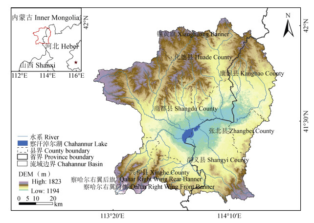
图1研究区地理位置示意图
Figure1.Location map of the study area
 下载: 全尺寸图片幻灯片
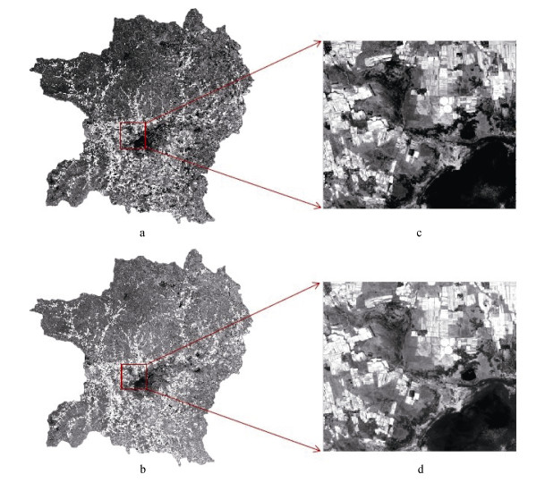
图2研究区Landsat NDVI影像与ESTARFM融合NDVI影像对比
a: 2017年8月25日Landsat-NDVI影像; b: ESTARFM融合的2017年8月25日NDVI; (c)和(d)分别是局部放大图像。a: Landsat-NDVI images in August 25, 2017; b: ESTARFM-integrated NDVI in August 25, 2017; (c) and (d) are partially enlarged images, respectively.
Figure2.Comparison of Landsat NDVI image and Enhanced Spatial and Temporal Adaptive Reflectance Fusion Model (ESTARFM) fusion NDVI image of the study area
下载: 全尺寸图片幻灯片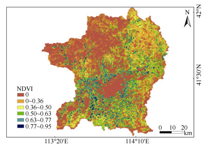
图3研究区耕地掩膜后ESTARFM融合NDVI影像
Figure3.Enhanced Spatial and Temporal Adaptive Reflectance Fusion Model (ESTARFM) fusion NDVI image after farmland masking of the study area
下载: 全尺寸图片幻灯片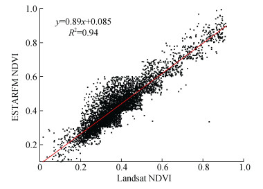
图4Landsat NDVI影像与ESTARFM NDVI影像散点图
Figure4.Scatter plot of Landsat NDVI image and Enhanced Spatial and Temporal Adaptive Reflectance Fusion Model (ESTARFM) NDVI image
下载: 全尺寸图片幻灯片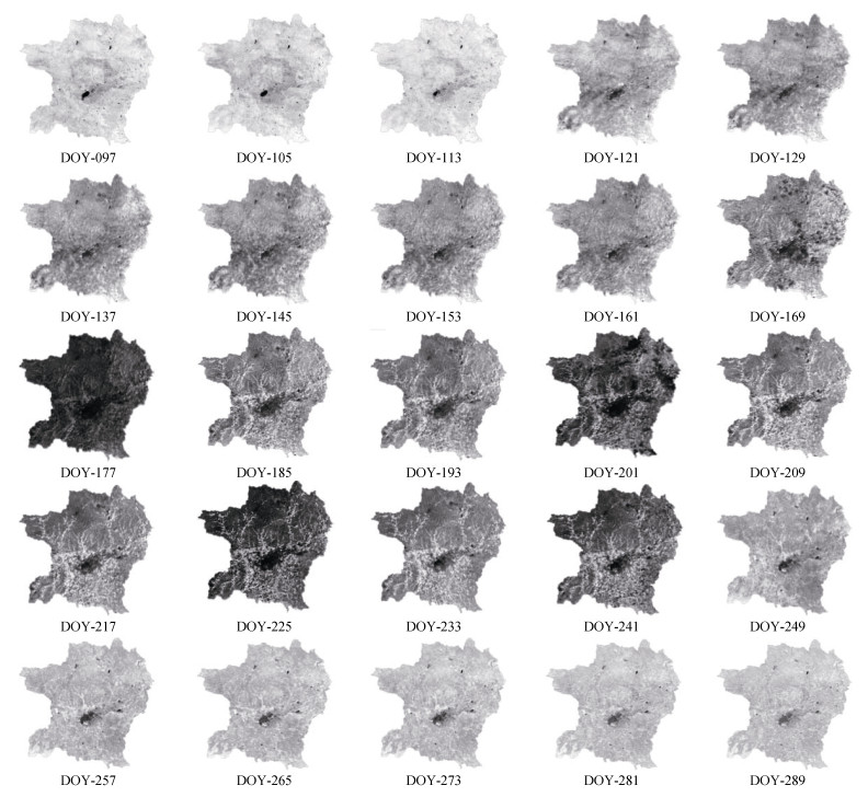
图5研究区26景高时空分辨率ESTARFM NDVI影像
DOY(day-of-year)为年积日, 表示一年中的一天。DOY is the accumulated day of the year, which means the day of the year.
Figure5.26 scenes high spatial and temporal resolution Enhanced Spatial and Temporal Adaptive Reflectance Fusion Model (ESTARFM) NDVI image of the study area
下载: 全尺寸图片幻灯片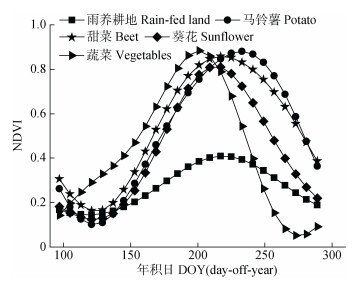
图6HANTS滤波后耕地NDVI时间序列变化曲线
Figure6.Time series change curves of cultivated land NDVI after Harmonic Analysis of NDVI Time-Series (HANTS) filtering
下载: 全尺寸图片幻灯片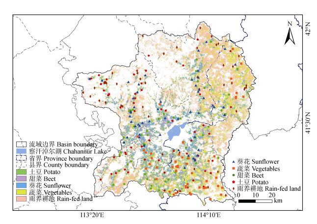
图7研究区内基于SVM灌溉耕地空间分布提取结果
Figure7.Extraction results of arable land spatial distribution based on SVM of the study area
下载: 全尺寸图片幻灯片表1察汗淖尔流域主要作物生育期
Table1.Growth periods of main crops in the Chahannur basin
| 4月April | 5月May | 6月June | 7月July | 8月August | 9月September | 10月上旬 Early in October | |||||||||||||
| 上旬 Early | 中旬 Mid-term | 下旬 Late | 上旬 Early | 中旬 Mid-term | 下旬 Late | 上旬 Early | 中旬 Mid-term | 下旬 Late | 上旬 Early | 中旬 Mid-term | 下旬 Late | 上旬 Early | 中旬 Mid-term | 下旬 Late | 上旬 Early | 中旬 Mid-term | 下旬 Late | ||
| 马铃薯 Potato | 播种 Sowing | 芽条生长期 Sprout growth period | 幼苗期 Seedling stage | 块茎形成期 Tuber formation | 块茎累积期 Tuber accumulation period | 淀粉累积期 Starch accumulation period | 成熟 Mature | ||||||||||||
| 葵花 Sunflower | 播种 Sowing | 出苗 Emergence | 现蕾 Budding | 开花 Flowering | |||||||||||||||
| 甜菜 Beat | 块根分化形成期 Tuber diiferentiation | 叶从快速牛长期 Rhizome rapid growth period | 块根及糖份增长期 Root and sugar growth period | 糖分累积期 Sugar accumulation period | |||||||||||||||
| 芹菜 Celery | 台苗(大棚) Nerser (greenhouse planting) | 定植 Colonization | 采收 Harvest | ||||||||||||||||
| 甘蓝 Cabbage | 苗期、莲座期 Seedling and rosette stage | 结球期 Heading phase | |||||||||||||||||
| 大白菜 Chinese Cabbage | 苗期 Seedling stage | 莲座期 Rosette stage | 结球期 Heading phase | ||||||||||||||||
| 小麦 Wheat | 播种 Sowing | 出苗 Emergence | 分蘖 Tiller | 拔节 Jointing | 抽穗 Earing | 成熟 Mature | |||||||||||||
| 莜麦 Naked Oats | 播种 Sowing | 出苗 Emergence | 分蘖 Tiller | 拔节 Jointing | 抽穗 Earing | 成熟 Mature | |||||||||||||
| 胡麻 Flax | 播种 Sowing | 出苗 Emergence | 现蕾期 Budding period | 花期 Flowering | 灌浆期 Grouting period | 成熟 Mature | |||||||||||||
下载: 导出CSV表2研究区不同类型作物的支持向量机(SVM)分类结果混淆矩阵
Table2.Confusion matrix of Support Vector Machine (SVM) classification results of different types of crops in the study area ?
| 项目 Item | 灌溉耕地作物Irrigated crop | 雨养Rainfed crop | |||||||
| 马铃薯Potato | 甜菜Beet | 葵花Sunflower | 蔬菜Vegetables | 小麦Wheat | |||||
| 制图精度Producer accuracy | 96.00 | 96.23 | 88.24 | 85.45 | 96.23 | ||||
| 用户精度User accuracy | 96.30 | 94.44 | 90.00 | 97.92 | 87.93 | ||||
| 错分误差Commission error | 3.70 | 5.56 | 10.00 | 2.08 | 12.07 | ||||
| 漏分误差Omission error | 0 | 3.77 | 11.76 | 14.55 | 3.77 | ||||
| 总分类精度=93.18%, Kappa系数=0.91。Overall accuracy=93.18%; Kappa coefficient=0.91. | |||||||||
下载: 导出CSV参考文献
| [1] | 高芳. 坝上地下水资源可持续利用问题探讨[J]. 河北水利, 2004, (10): 17-18 https://www.cnki.com.cn/Article/CJFDTOTAL-HBLS200410008.htm GAO F. Discussion on sustainable utilization of groundwater resources on Bashang[J]. Hebei Water Resources, 2004, (10): 17-18 https://www.cnki.com.cn/Article/CJFDTOTAL-HBLS200410008.htm |
| [2] | 刘淑慧. 坝上高原区节水灌溉措施节水量研究[D]. 保定: 河北农业大学, 2008 LIU S H. Study on the amount of saving water under the water-saving irrigation project in Bashang plateau[D]. Baoding: Hebei Agricultural University, 2008 |
| [3] | 刘苏英, 韩会玲. 浅谈坝上地区节水型农业模式[J]. 南水北调与水利科技, 2010, 8(2): 117-119 doi: 10.3969/j.issn.1672-1683.2010.02.032 LIU S Y, HAN H L. Simple analysis the model of water conservation in agriculture production at Bashang Region[J]. South-to-North Water Transfers and Water Science & Technology, 2010, 8(2): 117-119 doi: 10.3969/j.issn.1672-1683.2010.02.032 |
| [4] | 刘小鹏, 蔡军华. 我国农业用水现状和节水途径[J]. 科学时代, 2014, (13): 286 https://www.cnki.com.cn/Article/CJFDTOTAL-BJNY201209113.htm LIU X P, CAI J H. Current status of agricultural water use in China and ways to save water[J]. Scientific Age, 2014, (13): 286 https://www.cnki.com.cn/Article/CJFDTOTAL-BJNY201209113.htm |
| [5] | 李文红, 陶小平. 京津风沙源蔬菜业和水资源问题及对策研究[J]. 河北北方学院学报: 自然科学版, 2009, 25(5): 61-63 doi: 10.3969/j.issn.1673-1492.2009.05.018 LI W H, TAO X P. Research on problems and countermeasures of vegetable industry and water resources in Beijing-Tianjin sandstorm source[J]. Journal of Hebei North University: Natural Science Edition, 2009, 25(5): 61-63 doi: 10.3969/j.issn.1673-1492.2009.05.018 |
| [6] | 高素改. 河北坝上高原湖淖时空演化规律及其驱动力分析[D]. 石家庄: 河北师范大学, 2019 GAO S G. An analysis of temporal and spatial evolution laws and driving forces of lakes on Bashang Plateau in Hebei Province[D]. Shijiazhuang: Hebei Normal University, 2019 |
| [7] | 肖乾广, 周嗣松, 陈维英, 等. 用气象卫星数据对冬小麦进行估产的试验[J]. 环境遥感, 1986, 1(4): 260-269 https://www.cnki.com.cn/Article/CJFDTOTAL-YGXB198604002.htm XIAO Q G, ZHOU S S, CHEN W Y, et al. Productivity estimate using meteorological satellite[J]. Remote Sensing of Environment, 1986, 1(4): 260-269 https://www.cnki.com.cn/Article/CJFDTOTAL-YGXB198604002.htm |
| [8] | STIBIG H J, MALINGREAU J P. 用低空间分辨率的新近卫星图像对东南亚岛屿的森林覆被进行制图[J]. AMBIO-人类环境杂志, 2003, 32(7): 469-475 https://www.cnki.com.cn/Article/CJFDTOTAL-RLHJ200307006.htm STIBIG H J, MALINGREAU J P. Forest cover of insular southeast Asia mapped from recent satellite images of coarse spatial resolution[J]. AMBIO-A Journal of the Human Environment, 2003, 32(7): 469-475 https://www.cnki.com.cn/Article/CJFDTOTAL-RLHJ200307006.htm |
| [9] | VINTROU E, DESBROSSE A, BéGUé A, et al. Crop area mapping in west Africa using landscape stratification of MODIS time series and comparison with existing global land products[J]. International Journal of Applied Earth Observation and Geoinformation, 2012, 14(1): 83-93 doi: 10.1016/j.jag.2011.06.010 |
| [10] | 刘逸竹, 吴文斌, 李召良, 等. 灌溉耕地空间分布制图研究进展[J]. 中国农业资源与区划, 2017, 38(10): 1-13 doi: 10.7621/cjarrp.1005-9121.20171001 LIU Y Z, WU W B, LI Z L, et al. Recent progress in mapping irrigated cropland by remote sensing[J]. Chinese Journal of Agricultural Resources and Regional Planning, 2017, 38(10): 1-13 doi: 10.7621/cjarrp.1005-9121.20171001 |
| [11] | PERVEZ M S, BROWN J F. Mapping irrigated lands at 250-m scale by merging MODIS data and national agricultural statistics[J]. Remote Sensing, 2010, 2(10): 2388-2412 doi: 10.3390/rs2102388 |
| [12] | 刘逸竹, 吴文斌, 李召良, 等. 基于时间序列NDVI的灌溉耕地空间分布提取[J]. 农业工程学报, 2017, 33(22): 276-284 doi: 10.11975/j.issn.1002-6819.2017.22.036 LIU Y Z, WU W B, LI Z L, et al. Extracting irrigated cropland spatial distribution in China based on time-series NDVI[J]. Transactions of the Chinese Society of Agricultural Engineering, 2017, 33(22): 276-284 doi: 10.11975/j.issn.1002-6819.2017.22.036 |
| [13] | 潘学鹏, 李改欣, 刘峰贵, 等. 华北平原冬小麦面积遥感提取及时空变化研究[J]. 中国生态农业学报, 2015, 23(4): 497-505 http://www.ecoagri.ac.cn/zgstny/ch/reader/view_abstract.aspx?file_no=2015414&flag=1 PAN X P, LI G X, LIU F G, et al. Using remote sensing to determine spatio-temporal variations in winter wheat growing area in the North China Plain[J]. Chinese Journal of Eco-Agriculture, 2015, 23(4): 497-505 http://www.ecoagri.ac.cn/zgstny/ch/reader/view_abstract.aspx?file_no=2015414&flag=1 |
| [14] | 王红营, 潘学鹏, 罗建美, 等. 基于遥感的华北平原农作物时空分布变化特征分析[J]. 中国生态农业学报, 2015, 23(9): 1199-1209 http://www.ecoagri.ac.cn/zgstny/ch/reader/view_abstract.aspx?file_no=2015915&flag=1 WANG H Y, PAN X P, LUO J M, et al. Using remote sensing to analyze spatiotemporal variations in crop planting in the North China Plain[J]. Chinese Journal of Eco-Agriculture, 2015, 23(9): 1199-1209 http://www.ecoagri.ac.cn/zgstny/ch/reader/view_abstract.aspx?file_no=2015915&flag=1 |
| [15] | GAO F, MASEK J, SCHWALLER M, et al. On the blending of the Landsat and MODIS surface reflectance: Predicting daily Landsat surface reflectance[J]. IEEE Transactions on Geoscience and Remote Sensing, 2006, 44(8): 2207-2218 doi: 10.1109/TGRS.2006.872081 |
| [16] | ZHU X L, CHEN J, GAO F, et al. An enhanced spatial and temporal adaptive reflectance fusion model for complex heterogeneous regions[J]. Remote Sensing of Environment, 2010, 114(11): 2610-2623 doi: 10.1016/j.rse.2010.05.032 |
| [17] | 郝贵斌, 吴波, 张立福, 等. ESTARFM模型在西藏色林错湖面积时空变化中的应用分析(1976-2014年)[J]. 地球信息科学学报, 2016, 18(6): 833-846 https://www.cnki.com.cn/Article/CJFDTOTAL-DQXX201606018.htm HAO G B, WU B, ZHANG L F, et al. Temporal and spatial variation analysis of the area of Siling Co Lake in Tibet based on ESTARFM (1976-2014)[J]. Journal of Geo-Information Science, 2016, 18(6): 833-846 https://www.cnki.com.cn/Article/CJFDTOTAL-DQXX201606018.htm |
| [18] | 郭娇. 基于ESTARFM模型的西安地区植被覆盖度遥感估算与应用[D]. 西安: 西安科技大学, 2017 GUO J. Estimation and application of fractional vegetation cover in Xi'an based on ESTARFM model[D]. Xi'an: Xi'an University of Science and Technology, 2017 |
| [19] | 刘咏梅, 马黎, 黄昌, 等. 基于MODIS-Landsat时空融合的陕北黄土高原植被覆盖变化研究[J]. 西北大学学报: 自然科学版, 2019, 49(1): 62-70 https://www.cnki.com.cn/Article/CJFDTOTAL-XBDZ201901008.htm LIU Y M, MA L, HUANG C, et al. Study on the change of vegetation coverage of Loess Plateau in Northern Shaanxi Province based on MODIS-Landsat fusion data[J]. Journal of Northwest University: Natural Science Edition, 2019, 49(1): 62-70 https://www.cnki.com.cn/Article/CJFDTOTAL-XBDZ201901008.htm |
| [20] | 陈梦露, 李存军, 官云兰, 等. 基于ESTARFM模型的区域农田高时空分辨率影像产生与应用[J]. 作物学报, 2019, 45(7): 1099-1110 https://www.cnki.com.cn/Article/CJFDTOTAL-XBZW201907014.htm CHEN M L, LI C J, GUAN Y L, et al. Generation and application of high temporal and spatial resolution images of regional farmland based on ESTARFM model[J]. Acta Agronomica Sinica, 2019, 45(7): 1099-1110 https://www.cnki.com.cn/Article/CJFDTOTAL-XBZW201907014.htm |
| [21] | ZHU X F, ZHU W Q, ZHANG J S, et al. Mapping irrigated areas in China from remote sensing and statistical data[J]. IEEE Journal of Selected Topics in Applied Earth Observations and Remote Sensing, 2014, 7(11): 4490-4504 doi: 10.1109/JSTARS.2013.2296899 |
| [22] | 孙雷刚, 刘剑锋, 徐全洪. 河北坝上地区植被覆盖变化遥感时空分析[J]. 国土资源遥感, 2014, 26(1): 167-172 https://www.cnki.com.cn/Article/CJFDTOTAL-GTYG201401030.htm SUN L G, LIU J F, XU Q H. Remote Sensing based temporal and spatial analysis of vegetation cover changes in Bashang Area of Hebei Province[J]. Remote Sensing for Land & Resources, 2014, 26(1): 167-172 https://www.cnki.com.cn/Article/CJFDTOTAL-GTYG201401030.htm |
| [23] | JARIHANI A A, MCVICAR T R, VAN NIEL T G, et al. Blending Landsat and MODIS data to generate multispectral indices: A comparison of "index-then-blend" and "blend-then-index" approaches[J]. Remote Sensing, 2014, 6(10): 9213-9238 doi: 10.3390/rs6109213 |
| [24] | BAI L L, CAI J B, LIU Y, et al. Responses of field evapotranspiration to the changes of cropping pattern and groundwater depth in large irrigation district of Yellow River basin[J]. Agricultural Water Management, 2017, 188: 1-11 doi: 10.1016/j.agwat.2017.03.028 |
| [25] | HUANG C, CHEN Y, ZHANG S Q, et al. Surface water mapping from Suomi NPP-VIIRS imagery at 30 m resolution via blending with Landsat data[J]. Remote Sensing, 2016, 8: 631 doi: 10.3390/rs8080631 |
| [26] | 郭文静, 李爱农, 赵志强, 等. 基于AVHRR和TM数据的时间序列较高分辨率NDVI数据集重构方法[J]. 遥感技术与应用, 2015, 30(2): 267-276 https://www.cnki.com.cn/Article/CJFDTOTAL-YGJS201502010.htm GUO W J, LI A N, ZHAO Z Q, et al. Constructing the time-series NDVI dataset with a high spatial and temporal resolution through fusing AVHRR with TM data[J]. Remote Sensing Technology and Application, 2015, 30(2): 267-276 https://www.cnki.com.cn/Article/CJFDTOTAL-YGJS201502010.htm |
| [27] | LEBRINI Y, BOUDHAR A, HADRIA R, et al. Identifying agricultural systems using SVM classification approach based on phenological metrics in a semi-arid region of morocco[J]. Earth Systems and Environment, 2019, 3(2): 277-288 doi: 10.1007/s41748-019-00106-z |
| [28] | SHAO Y, LUNETTA R S. Comparison of support vector machine, neural network, and CART algorithms for the land-cover classification using limited training data points[J]. ISPRS Journal of Photogrammetry and Remote Sensing, 2012, 70: 78-87 doi: 10.1016/j.isprsjprs.2012.04.001 |
| [29] | 刘纯, 洪亮, 陈杰, 等. 融合像素-多尺度区域特征的高分辨率遥感影像分类算法[J]. 遥感学报, 2015, 19(2): 228-239 https://www.cnki.com.cn/Article/CJFDTOTAL-YGXB201502007.htm LIU C, HONG L, CHEN J, et al. Fusion of pixel-based and multi-scale region-based features for the classification of high-resolution remote sensing image[J]. Journal of Remote Sensing, 2015, 19(2): 228-239 https://www.cnki.com.cn/Article/CJFDTOTAL-YGXB201502007.htm |
| [30] | JIN N, TAO B, REN W, et al. Mapping irrigated and rainfed wheat areas using multi-temporal satellite data[J]. Remote Sensing, 2016, 8(3): 207 doi: 10.3390/rs8030207 |
| [31] | 夏玉计. 基于多特征融合支持向量机的土地覆盖类型提取与分析[D]. 北京: 中国地质大学, 2019 XIA Y J. The extraction and analysis of land cover type based on multi-feature fusion support vector machine[D]. Beijing: China University of Geosciences, 2019 |
| [32] | 程彬. 基于支持向量机的乾安县土地利用遥感分类研究[J]. 长春师范大学学报, 2017, 36(12): 86-88 https://www.cnki.com.cn/Article/CJFDTOTAL-CCSS201712019.htm CHENG B. Land use information extraction based on support vector machine using multitemporal remote sensing in Qian'an County[J]. Journal of Changchun Normal University, 2017, 36(12): 86-88 https://www.cnki.com.cn/Article/CJFDTOTAL-CCSS201712019.htm |
| [33] | GONG P, WANG J, YU L, et al. Finer resolution observation and monitoring of global land cover: First mapping results with Landsat TM and ETM+data[J]. International Journal of Remote Sensing, 2013, 34(7): 2607-2654 doi: 10.1080/01431161.2012.748992 |
| [34] | MAYAUX P, EVA H, GALLEGO J, et al. Validation of the global land cover 2000 map[J]. IEEE Transactions on Geoscience and Remote Sensing, 2006, 44(7): 1728-1739 doi: 10.1109/TGRS.2006.864370 |
| [35] | 张荣群, 王盛安, 高万林, 等. 基于时序植被指数的县域作物遥感分类方法研究[J]. 农业机械学报, 2015, 46(S1): 246-252 https://www.cnki.com.cn/Article/CJFDTOTAL-NYJX2015S1040.htm ZHANG R Q, WANG S A, GAO W L, et al. Remote-sensing classification method of county-level agricultural crops using time-series NDVI[J]. Transactions of the Chinese Society for Agricultural Machinery, 2015, 46(S1): 246-252 https://www.cnki.com.cn/Article/CJFDTOTAL-NYJX2015S1040.htm |
| [36] | SHAMAL S A M, WEATHERHEAD K. Assessing spectral similarities between rainfed and irrigated croplands in a humid environment for irrigated land mapping[J]. Outlook on Agriculture, 2014, 43(2): 109-114 doi: 10.5367/oa.2014.0168 |
| [37] | KAMTHONKIAT D, HONDA K, TURRAL H, et al. Discrimination of irrigated and rainfed rice in a tropical agricultural system using SPOT VEGETATION NDVI and rainfall data[J]. International Journal of Remote Sensing, 2005, 26(12): 2527-2547 |
| [38] | 高占义. 中国的灌溉发展及其作用[J]. 水利经济, 2006, 24(1): 36-39 https://www.cnki.com.cn/Article/CJFDTOTAL-SLJJ200601013.htm GAO Z Y. China's irrigation development and its role[J]. WaterEconomy, 2006, 24(1): 36-39 https://www.cnki.com.cn/Article/CJFDTOTAL-SLJJ200601013.htm |
| [39] | OZDOGAN M, GUTMAN G. A new methodology to map irrigated areas using multi-temporal MODIS and ancillary data: An application example in the continental US[J]. Remote Sensing of Environment, 2008, 112(9): 3520-3537 http://www.sciencedirect.com/science/article/pii/S0034425708001338 |
| [40] | 董婷婷, 左丽君, 张增祥. MODIS数据的水浇地提取[J]. 遥感学报, 2009, 13(3): 528-534 https://www.cnki.com.cn/Article/CJFDTOTAL-YGXB200903028.htm DONG T T, ZUO L J, ZHANG Z X. Extracting irrigated land based on MODIS data[J]. Journal of Remote Sensing, 2009, 13(3): 528-534 https://www.cnki.com.cn/Article/CJFDTOTAL-YGXB200903028.htm |
| [41] | XIE Y H, LARK T J, BROWN J F, et al. Mapping irrigated cropland extent across the conterminous United States at 30 m resolution using a semi-automatic training approach on Google Earth Engine[J]. ISPRS Journal of Photogrammetry and Remote Sensing, 2019, 155: 136-149 http://www.sciencedirect.com/science/article/pii/S0924271619301728 |
