谭香2,
李发东1,
阮宏威1,
于静洁1,
高扬1,
翟晓燕3
1.中国科学院地理科学与资源研究所/中国科学院陆地水循环及地表过程重点实验室 北京 100101
2.中国科学院武汉 植物园/中国科学院水生植物与流域生态重点实验室 武汉 430074
3.中国水利水电科学研究院 北京 100038
基金项目: 中国科学院战略性先导科技专项XDA20040301
国家自然科学基金项目41807171
详细信息
作者简介:张永勇, 研究方向为流域水循环与环境水文学。E-mail: zhangyy003@igsnrr.ac.cn
中图分类号:P95计量
文章访问数:303
HTML全文浏览量:4
PDF下载量:93
被引次数:0
出版历程
收稿日期:2020-06-06
录用日期:2020-09-22
刊出日期:2021-02-01
Spatial variation in major water quality types and its relationships with land cover in the middle and lower reaches of Aral Sea Basin
ZHANG Yongyong1,,,TAN Xiang2,
LI Fadong1,
RUAN Hongwei1,
YU Jingjie1,
GAO Yang1,
ZHAI Xiaoyan3
1. Institute of Geographic Sciences and Natural Resources Research/Key Laboratory of Water Cycle and Related Land Surface Processes, Chinese Academy of Sciences, Beijing 100101, China
2. Key Laboratory of Aquatic Botany and Watershed Ecology, Chinese Academy of Sciences/Wuhan Botanical Garden, Chinese Academy of Sciences, Wuhan 430074, China
3. Institute of Water Resources and Hydropower Research, Beijing 100038, China
Funds: the Strategic Priority Research Program of Chinese Academy of SciencesXDA20040301
the National Natural Science Foundation of China41807171
More Information
Corresponding author:ZHANG Yongyong, E-mail: zhangyy003@gsnr.ac.cn
摘要
HTML全文
图
参考文献
相关文章
施引文献
资源附件
访问统计
摘要
摘要:中亚咸海流域的资源和环境问题一直是全球关注的热点。为揭示咸海流域水环境变化及其成因,本文利用2019年中下游流域21个采样点水质数据,通过主成分、聚类和秩次等多元统计分析方法相结合,分析了水体的基础理化属性、氮磷营养元素、其他元素和离子等20种指标的空间分布特征,辨识了该流域主要水质类型、空间分布及成因,探索了不同空间尺度土地覆被类型对水质类型的影响。结果表明:1)电导率、总溶解性固体物质和离子浓度越往河流下游数值越高,其中在咸海最大;不同形态磷元素浓度在阿姆河中游较高,硝态氮浓度在锡尔河较高;碳元素浓度也在阿姆河,特别是阿姆河下游三角洲地区较高。2)所有采样点水体根据水质指标相似性聚类可划分为3种综合性水质类型。第1类型为水质指标浓度均偏低的水体,分布在锡尔河中游和咸海;第2类型为氮磷营养元素浓度偏高的水体,分布在阿姆河中下游;第3类为碳元素和离子浓度均偏高的水体,分布在咸海。第1和2类型水体的元素浓度主要受荒漠地区岩石风化过程控制,阴阳离子来源于硅酸盐岩和蒸发岩的风化;第3类型水体主要受气候干燥导致的蒸发-结晶过程控制,阴阳离子除来源于硅酸盐岩和蒸发岩的风化外,还受碳酸盐岩风化影响。3)当各采样点缓冲区半径从0.5 km增加到10 km时,对第1类型水质浓度变化影响显著的土地覆被类型逐渐从荒地变为水域、灌木、草地和农田与植被混合,其中水域的影响最大;第2类型水质浓度变化与土地覆被类型无显著性关系;对第3类型水质浓度变化影响显著的土地覆被类型从水域变为水域、农田与植被混合等,其中水域的影响最大。因此,咸海流域水质浓度变化与当地干旱缺水和蒸发剧烈等气象条件以及土地覆被类型有密切关系。为改善咸海中下游流域水环境状况,在增加中下游河道流量和咸海的补给,减弱下游和咸海蒸发-结晶作用的同时,还需加大河岸带的植被修复和退耕还林还草,特别是在阿姆河和锡尔河中下游农业区、咸海等地区。
关键词:水质类型/
空间尺度/
土地覆被/
多元统计分析/
咸海流域
Abstract:Water resources and environmental issues in the Aral Sea Basin of Central Asia are global concerns. In this study, the water quality variables (i.e., basic physical and chemical attributes, different forms of nutrients, other elements, cations, and anions) from 21 sampling sites in the middle and lower reaches of Aral Sea Basin were measured in 2019 to explore water environmental variations and their causes. Spatial variation in 20 water quality variables was investigated, and the representative water quality types, spatial differences, and their causes were identified via multivariate analysis methods (i.e., principal component analysis and cluster analysis). Furthermore, the effects of land cover on the spatial variation in water quality types were explored. The results showed that: 1) the values of electronic conductivity (EC) and total dissolved solids (TDS) increased from the middle to the lower reaches, and the highest values were in the Aral Sea. This indicates that the concentrations of anions and cations increased from the middle to the lower reaches. For the nutrient variables, high phosphorous concentrations were in the middle reaches of Amu Darya, and high nitrate-nitrogen concentrations were in the Syr Darya. For the different forms of carbon, the highest concentrations were in the Amu Darya, particularly in the delta area of lower reaches. 2) The water quality at all sampling sites can be divided into three water quality types according to the similarity classification of water quality variables. The first type had low concentrations for most water quality variables, which were distributed in the middle reaches of Syr Darya and the Aral Sea. The second type had high concentrations of different forms of nitrogen and phosphorus, which were distributed in the middle and lower reaches of Amu Darya. The third type had high concentrations of carbon, anions, and cations, which were distributed in the Aral Sea. The water quality concentrations of the first and second types were mainly due to rock weathering processes on bare land, and the anions and cations were mainly derived from the weathering of silicates and evaporites. The concentrations of the third type were mainly due to the evaporation and crystallization processes of a dry climate, and the anions and cations were mainly derived from the weathering of silicates and evaporites, which may also be affected by carbonate weathering. 3) With an increase in the buffer zone radius for each sampling point (0.5 km to 10 km), the significant land cover changed from bare land to water, shrubland, grassland, mixed farmland, and vegetation for the first water quality type; the most significant land cover was water. There were no significant relationships between the second water quality type and land cover. For the third water quality type, the significant land cover changed from water to water, mixed farmland, and vegetation—the most significant land cover was water. Therefore, spatial variation in the water quality variables was mainly affected by the local climate conditions (i.e., climatic drought and intensive evapotranspiration) and the mainland cover types (i.e., bare land, water, farmland, grassland, and urban). To improve the water environmental conditions in the middle and lower reaches of Aral Sea Basin, stream flow should be increased to recharge the Aral Sea and weaken the evaporation and crystallization processes in the lower reaches of Aral Sea. Vegetation restoration and a return of farmland to forest and grassland should also be strengthened in the riparian zone, particularly in the middle and lower reaches of Amu Darya and Syr Darya and the Aral Sea.
Key words:Water quality types/
Spatial scale/
Land cover/
Multivariate analysis/
Aral Sea Bain
HTML全文
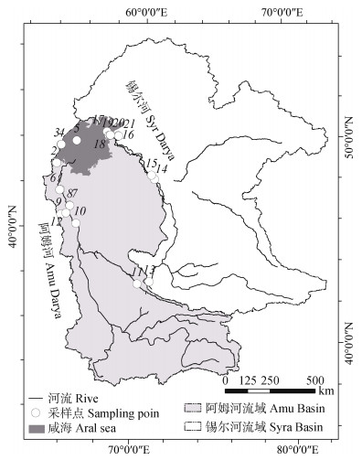
图1咸海流域位置与水质采样点分布
Figure1.Location of the Aral Sea Basin and spatial distributions of water quality sampling points
 下载: 全尺寸图片幻灯片
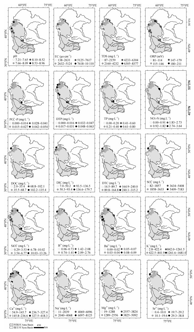
图2咸海流域各水质指标的空间分布特征
EC: 电导率; TDS: 总溶解性固体物质; ORP: 氧化还原电位; PO43--P: 正磷酸盐; DTP: 总溶解性磷; TP: 总磷; NO3--N: 硝态氮; DOC: 溶解有机碳; DIC: 溶解无机碳; DTC: 总溶解碳。
Figure2.Regional distributions of individual water quality variables in the Aral Sea Basin
EC: electrical conductivity; TDS: total dissolved solids; ORP: oxidation-reduction potential; PO43--P: orthophosphate; DTP: dissolved total phosphorus; TP: total phosphorus; NO3--N: nitrate nitrogen; DOC: dissolved organic carbon; DIC: dissolved inorganic carbon; DTC: dissolved total carbon.
下载: 全尺寸图片幻灯片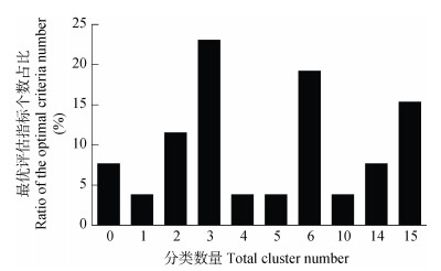
图3不同分类数量最优聚类评估指标数量占比
Figure3.Ratios of the optimal criteria numbers for different classification performance assessment
下载: 全尺寸图片幻灯片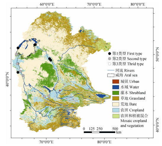
图4咸海流域水质类型和土地覆被的空间分布特征
Figure4.Spatial characteristics of water quality types and land covers in the Aral Sea Basin
下载: 全尺寸图片幻灯片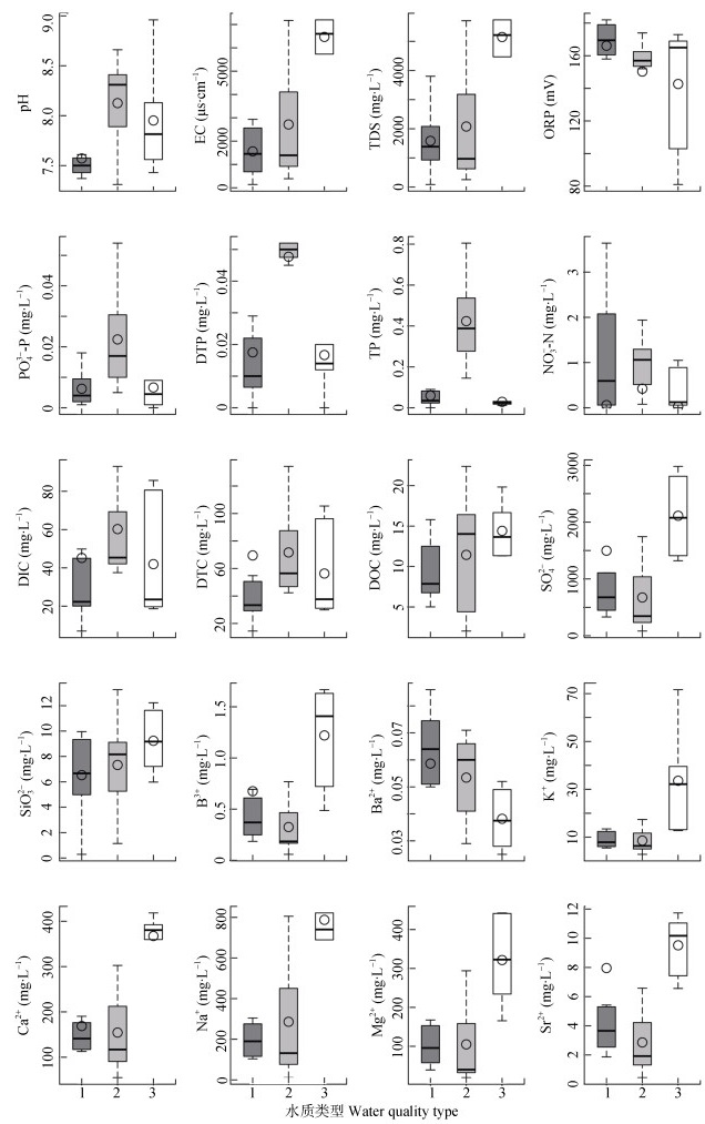
图5咸海流域水质指标在不同水质类型间的差异
EC: 电导率; TDS: 总溶解性固体物质; ORP: 氧化还原电位; PO43--P: 正磷酸盐; DTP: 总溶解性磷; TP: 总磷; NO3--N: 硝态氮; DOC: 溶解有机碳; DIC: 溶解无机碳; DTC: 总溶解碳。
Figure5.Differences of water quality variables among different water quality types in the Aral Sea Basin
EC: electrical conductivity; TDS: total dissolved solids; ORP: oxidation-reduction potential; PO43--P: orthophosphate; DTP: dissolved total phosphorus; TP: total phosphorus; NO3--N: nitrate nitrogen; DOC: dissolved organic carbon; DIC: dissolved inorganic carbon; DTC: dissolved total carbon.
下载: 全尺寸图片幻灯片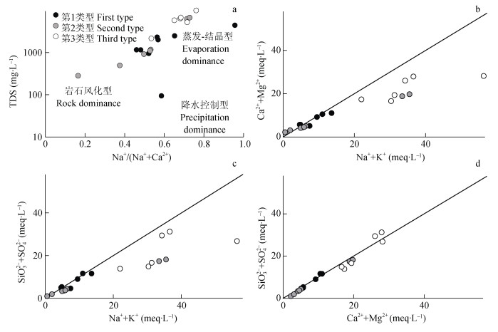
图6咸海流域总溶解性固体物质(TDS)浓度与Na+/(Na++Ca2+)(a)、Ca2++Mg2+和Na++K+(b)、SO42-+SiO32-和Na++K+(c)、SO42-+SiO32-和Ca2++Mg2+(d)摩尔浓度的相关关系
Figure6.Relationships between concentrations of total dissolved solids (TDS) and Na+/(Na++Ca2+) (a), molar concentrations of Ca2++Mg2+ and Na++K+(b), SO42-+SiO32- and Na++K+(c), SO42-+SiO32- and Ca2++Mg2+ (d) in the Aral Sea Basin
下载: 全尺寸图片幻灯片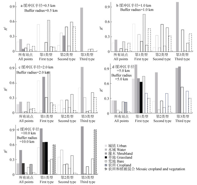
图7咸海流域不同半径(a: 0.5 km, b: 1.0 km, c: 2.0 km, d: 5.0 km, e: 10.0 km)缓冲区下影响各水质类型的关键土地覆被类型
不同实心柱代表通过显著性检验的土地覆被类型(P≤0.10), 空心柱代表不显著的土地覆被类型。
Figure7.Major land covers affecting the individual water quality types in different buffer radiuses (a: 0.5 km, b: 1.0 km, c: 2.0 km, d: 5.0 km, e: 10.0 km) in the Aral Sea Basin
Solid bars with different colors mean significant land covers (P≤0.10), and the hollow bars with different colors mean insignificant land covers.
下载: 全尺寸图片幻灯片表1咸海流域主成分对应的水质指标相关系数
Table1.Correlation coefficients among different water quality variables in selected principal components in the Aral Sea Basin
| 水质指标 Water quality variable | 主成分1 1st principal component | 主成分2 2nd principal component | 主成分3 3rd principal component | 主成分4 4th principal component |
| pH | -0.21 | 0.48 | 0.37 | -0.66 |
| 电导率 Electrical conductivity (EC) | 0.21 | -0.83 | 0.46 | 0.05 |
| 总溶解性固体物质 Total dissolved solids (TDS) | 0.52 | -0.73 | 0.36 | 0.05 |
| 氧化还原电位 Oxidation-reduction potential (ORP) | -0.38 | -0.37 | -0.21 | 0.74 |
| 正磷酸盐 Orthophosphate (PO43--P) | 0.05 | 0.44 | 0.65 | 0.18 |
| 溶解性总磷 Dissolved total phosphorus (DTP) | 0.37 | 0.61 | 0.52 | 0.14 |
| 总磷 Total phosphorus (TP) | -0.06 | 0.62 | 0.51 | 0.34 |
| 硝态氮 Nitrate nitrogen (NO3--N) | -0.48 | 0.45 | -0.28 | -0.18 |
| 溶解有机碳 Dissolved organic carbon (DOC) | 0.93 | 0.27 | -0.21 | 0.01 |
| 溶解无机碳 Dissolved inorganic carbon (DIC) | 0.77 | 0.31 | 0.13 | 0.25 |
| 总溶解碳 Dissolved total carbon (DTC) | 0.88 | 0.31 | 0.00 | 0.16 |
| SO42- | 0.97 | -0.16 | -0.11 | -0.05 |
| SiO32- | -0.58 | -0.01 | -.01 | -0.50 |
| B3+ | 0.87 | -0.31 | -0.03 | -0.21 |
| Ba2+ | -0.80 | 0.14 | -0.36 | 0.18 |
| K+ | 0.89 | 0.32 | -0.29 | -0.01 |
| Ca2+ | 0.65 | -0.59 | 0.28 | -0.24 |
| Na+ | 0.95 | 0.19 | -0.22 | -0.01 |
| Mg2+ | 0.93 | 0.25 | -0.26 | -0.01 |
| Sr2+ | 0.97 | -0.03 | -0.17 | -0.11 |
| 主成分方差 Variance (%) | 48.64 | 18.52 | 10.27 | 8.36 |
| 累积方差 Cumulative variances (%) | 85.78 | |||
| 加粗字体为该主成分中代表性水质指标。Bold fonts mean the representative water quality variables of individual principal components | ||||
下载: 导出CSV参考文献
| [1] | 邓铭江, 龙爱华. 咸海流域水文水资源演变与咸海生态危机出路分析[J]. 冰川冻土, 2011, 33(6): 1363-1375 https://www.cnki.com.cn/Article/CJFDTOTAL-BCDT201106020.htm DENG M J, LONG A H. Evolution of hydrologic and water resources and ecological crisis in the Aral Sea Basin[J]. Journal of Glaciology and Geocryology, 2011, 33(6): 1363-1375 https://www.cnki.com.cn/Article/CJFDTOTAL-BCDT201106020.htm |
| [2] | 阿布都米吉提·阿布力克木, 葛拥晓, 王亚俊, 等. 咸海的过去、现在与未来[J]. 干旱区研究, 2019, 36(1): 7-18 https://www.cnki.com.cn/Article/CJFDTOTAL-GHQJ201901003.htm ABLEKIM A, GE Y X, WANG Y J, et al. The past, present and feature of the Aral Sea[J]. Arid Zone Research, 2019, 36(1): 7-18 https://www.cnki.com.cn/Article/CJFDTOTAL-GHQJ201901003.htm |
| [3] | 杨胜天, 于心怡, 丁建丽, 等. 中亚地区水问题研究综述[J]. 地理学报, 2017, 72(1): 79-93 https://www.cnki.com.cn/Article/CJFDTOTAL-DLXB201701008.htm YANG S T, YU X Y, DING J L, et al. A review of water issues research in Central Asia[J]. Acta Geographica Sinica, 2017, 72(1): 79-93 https://www.cnki.com.cn/Article/CJFDTOTAL-DLXB201701008.htm |
| [4] | 李思悦, 谭香, 徐志方, 等. 湖北丹江口水库主要离子化学季节变化及离子来源分析[J]. 环境科学, 2008, 29(12): 3353-3359 doi: 10.3321/j.issn:0250-3301.2008.12.010 LI S Y, TAN X, XU Z F, et al. Seasonal variation in the major ion chemistry and their sources in the Hubei Danjiangkou Reservoir, China[J]. Environmental Science, 2008, 29(12): 3353-3359 doi: 10.3321/j.issn:0250-3301.2008.12.010 |
| [5] | 黄金良, 黄亚玲, 李青生, 等. 流域水质时空分布特征及其影响因素初析[J]. 环境科学, 2012, 33(4): 1098-1107 https://www.cnki.com.cn/Article/CJFDTOTAL-HJKZ201204011.htm HUANG J L, HUANG Y L, LI Q S, et al. Preliminary analysis of spatiotemporal variation of water quality and its influencing factors in the Jiulong River Watershed[J]. Environmental Science, 2012, 33(4): 1098-1107 https://www.cnki.com.cn/Article/CJFDTOTAL-HJKZ201204011.htm |
| [6] | 许尔琪. 土地利用对水体营养物影响的研究进展[J]. 中国生态农业学报(中英文), 2019, 27(12): 1880-1891 http://www.ecoagri.ac.cn/zgstny/ch/reader/view_abstract.aspx?file_no=2019-1210&flag=1 XU E Q. Research progress in the impact of land use on water nutrients[J]. Chinese Journal of Eco-Agriculture, 2019, 27(12): 1880-1891 http://www.ecoagri.ac.cn/zgstny/ch/reader/view_abstract.aspx?file_no=2019-1210&flag=1 |
| [7] | 曹艳敏, 毛德华, 吴昊, 等. 湘江干流水环境质量演变特征及其关键因素定量识别[J]. 长江流域资源与环境, 2019, 28(5): 1235-1243 https://www.cnki.com.cn/Article/CJFDTOTAL-CJLY201905023.htm CAO Y M, MAO D H, WU H, et al. The evolution features of water environmental quality and quantitative identification of key factors on Xiangjiang River[J]. Resources and Environment in the Yangtze Basin, 2019, 28(5): 1235-1243 https://www.cnki.com.cn/Article/CJFDTOTAL-CJLY201905023.htm |
| [8] | 开金磊, 王君波, 黄磊, 等. 西藏纳木错及其入湖河流溶解有机碳和总氮浓度的季节变化[J]. 湖泊科学, 2019, 31(4): 1099-1108 https://www.cnki.com.cn/Article/CJFDTOTAL-FLKX201904020.htm KAI J L, WANG J B, HUANG L, et al. Seasonal variations of dissolved organic carbon and total nitrogen concentrations in Nam Co and inflowing rivers, Tibet Plateau[J]. Journal of Lake Sciences, 2019, 31(4): 1099-1108 https://www.cnki.com.cn/Article/CJFDTOTAL-FLKX201904020.htm |
| [9] | 孙金华, 曹晓峰, 黄艺. 滇池水质时空特征及与流域人类活动的关系[J]. 湖泊科学, 2012, 24(3): 347-354 doi: 10.3969/j.issn.1003-5427.2012.03.004 SUN J H, CAO X F, HUANG Y. Relationships between spatial-temporal trends of water quality and the human activities in Lake Dianchi[J]. Journal of Lake Sciences, 2012, 24(3): 347-354 doi: 10.3969/j.issn.1003-5427.2012.03.004 |
| [10] | 罗献宝, 文军, 骆东奇, 等. 千岛湖水质变化特征与趋势分析[J]. 中国生态农业学报, 2006, 14(4): 208-212 http://www.ecoagri.ac.cn/zgstny/ch/reader/view_abstract.aspx?file_no=2006454&flag=1 LUO X B, WEN J, LUO D Q, et al. Changing characteristic and trend analysis of water quality of Qiandao Lake[J]. Chinese Journal of Eco-Agriculture, 2006, 14(4): 208-212 http://www.ecoagri.ac.cn/zgstny/ch/reader/view_abstract.aspx?file_no=2006454&flag=1 |
| [11] | 罗巧, 李勇, 吴金水. 亚热带典型农业小流域井水水质季节变化与空间分布特征[J]. 中国生态农业学报, 2016, 24(6): 829-836 http://www.ecoagri.ac.cn/zgstny/ch/reader/view_abstract.aspx?file_no=2016615&flag=1 LUO Q, LI Y, WU J S. Seasonal dynamics and spatial distribution of well water quality in a small typical agricultural catchment in subtropical China[J]. Chinese Journal of Eco-Agriculture, 2016, 24(6): 829-836 http://www.ecoagri.ac.cn/zgstny/ch/reader/view_abstract.aspx?file_no=2016615&flag=1 |
| [12] | 杨琴, 汤秋鸿, 张永勇. 淮河流域(河南段)水质时空变化特征及其与土地利用类型的关系[J]. 环境科学研究, 2019, 32(9): 1519-1530 https://www.cnki.com.cn/Article/CJFDTOTAL-HJKX201909010.htm YANG Q, TANG Q H, ZHANG Y Y. Spatiotemporal changes of water quality in Huai River Basin (Henan Section) and its correlation with land use patterns[J]. Research of Environmental Sciences, 2019, 32(9): 1519-1530 https://www.cnki.com.cn/Article/CJFDTOTAL-HJKX201909010.htm |
| [13] | 周丰, 郭怀成, 黄凯, 等. 基于多元统计方法的河流水质空间分析[J]. 水科学进展, 2007, 18(4): 544-551 doi: 10.3321/j.issn:1001-6791.2007.04.011 ZHOU F, GUO H C, HUANG K, et al. Multivariate statistical technique for spatial variation in river water quality[J]. Advances in Water Science, 2007, 18(4): 544-551 doi: 10.3321/j.issn:1001-6791.2007.04.011 |
| [14] | ZHANG Y Y, ZHOU Y J, SHAO Q X, et al. Diffuse nutrient losses and the impact factors determining their regional differences in four catchments from North to South China[J]. Journal of Hydrology, 2016, 543: 577-594 doi: 10.1016/j.jhydrol.2016.10.031 |
| [15] | 彭福利, 张永勇, 李茜, 等. 官厅水库入库断面水质多指标评价与演变特征分析[J]. 中国环境监测, 2020, 36(1): 65-74 https://www.cnki.com.cn/Article/CJFDTOTAL-IAOB202001012.htm PENG F L, ZHANG Y Y, LI Q, et al. Multi-index evaluation and evolution characteristic analysis of water quality at inlet section of Guanting Reservoir[J]. Environmental Monitoring in China, 2020, 36(1): 65-74 https://www.cnki.com.cn/Article/CJFDTOTAL-IAOB202001012.htm |
| [16] | 张洪, 陈震, 张帅, 等. 云南省高原湖泊流域土地利用与水环境变化异质性研究[J]. 水土保持通报, 2012, 32(2): 255-260 https://www.cnki.com.cn/Article/CJFDTOTAL-STTB201202056.htm ZHANG H, CHEN Z, ZHANG S, et al. Heterogeneity of land use and water environment in plateau lake basins of Yunnan Province[J]. Bulletin of Soil and Water Conservation, 2012, 32(2): 255-260 https://www.cnki.com.cn/Article/CJFDTOTAL-STTB201202056.htm |
| [17] | ZHAI X Y, XIA J, ZHANG Y Y. Water quality variation in the highly disturbed Huai River Basin, China from 1994 to 2005 by multi-statistical analyses[J]. Science of the Total Environment, 2014, 496: 594-606 doi: 10.1016/j.scitotenv.2014.06.101 |
| [18] | ZHANG Y Y, SHAO Q X, YE A Z, et al. Integrated water system simulation by considering hydrological and biogeochemical processes: Model development, with parameter sensitivity and autocalibration[J]. Hydrology and Earth System Sciences, 2016, 20(1): 529-553 doi: 10.5194/hess-20-529-2016 |
| [19] | UNGER-SHAYESTEH K, VOROGUSHYN S, FARINOTTI D, et al. What do we know about past changes in the water cycle of Central Asian headwaters? A review[J]. Global and Planetary Change, 2013, 110: 4-25 doi: 10.1016/j.gloplacha.2013.02.004 |
| [20] | CHEN Y N, LI Z, FANG G H, et al. Large hydrological processes changes in the transboundary rivers of Central Asia[J]. Journal of Geophysical Research: Atmospheres, 2018, 123(10): 5059-5069 doi: 10.1029/2017JD028184 |
| [21] | 邓铭江, 龙爱华, 章毅, 等. 中亚五国水资源及其开发利用评价[J]. 地球科学进展, 2010, 25(12): 1347-1356 https://www.cnki.com.cn/Article/CJFDTOTAL-DXJZ201012007.htm DENG M J, LONG A H, ZHANG Y, et al. Assessment of water resources development and utilization in the five Central Asia countries[J]. Advances in Earth Science, 2010, 25(12): 1347-1356 https://www.cnki.com.cn/Article/CJFDTOTAL-DXJZ201012007.htm |
| [22] | 姚海娇, 周宏飞. 中亚五国咸海流域水资源策略的博弈分析[J]. 干旱区地理, 2013, 36(4): 764-771 https://www.cnki.com.cn/Article/CJFDTOTAL-GHDL201304036.htm YAO H J, ZHOU H F. Game analysis of water resources strategy among the Central Asia Countries around the Aral Sea Basin[J]. Arid Land Geography, 2013, 36(4): 764-771 https://www.cnki.com.cn/Article/CJFDTOTAL-GHDL201304036.htm |
| [23] | 阮宏威, 于静洁. 1992—2015年中亚五国土地覆盖与蒸散发变化[J]. 地理学报, 2019, 74(7): 1292-1304 https://www.cnki.com.cn/Article/CJFDTOTAL-DLXB201907003.htm RUAN H W, YU J J. Changes in land cover and evapotranspiration in the five Central Asian countries from 1992 to 2015[J]. Acta Geographica Sinica, 2019, 74(7): 1292-1304 https://www.cnki.com.cn/Article/CJFDTOTAL-DLXB201907003.htm |
| [24] | 张永勇, 陈秋潭. 淮河中上游流域洪水主要类型及其时空分布特征[J]. 地理科学进展, 2020, 39(4): 627-635 https://www.cnki.com.cn/Article/CJFDTOTAL-DLKJ202004009.htm ZHANG Y Y, CHEN Q T. Characteristics of main flood event types and their temporal-spatial variations in the upper and middle reaches of the Huai River Basin[J]. Progress in Geography, 2020, 39(4): 627-635 https://www.cnki.com.cn/Article/CJFDTOTAL-DLKJ202004009.htm |
| [25] | ZHANG Y Y, ZHAI X Y, SHAO Q X, et al. Assessing temporal and spatial alterations of flow regimes in the regulated Huai River Basin, China[J]. Journal of Hydrology, 2015, 529: 384-397 doi: 10.1016/j.jhydrol.2015.08.001 |
| [26] | ZHANG Y Y, FU G B, SUN B Y, et al. Simulation and classification of the impacts of projected climate change on flow regimes in the arid Hexi Corridor of Northwest China[J]. Journal of Geophysical Research: Atmospheres, 2015, 120(15): 7429-7453 doi: 10.1002/2015JD023294 |
| [27] | ZHOU Y J, ZHANG Y Y, LIANG T, et al. Shifting of phytoplankton assemblages in a regulated Chinese river basin after streamflow and water quality changes[J]. Science of the Total Environment, 2019, 654: 948-959 doi: 10.1016/j.scitotenv.2018.10.348 |
| [28] | CHARRAD M, GHAZZALI N, BOITEAU V, et al. NbClust: An R package for determining the relevant number of clusters in a data set[J]. Journal of Statistical Software, 2014, 61(6): 1-36 http://www.researchgate.net/publication/267210575_NbClust_An_R_Package_for_Determining_the_Relevant_Number_of_Clusters_in_a_Data_Set |
| [29] | GIBBS R J. Mechanisms controlling world water chemistry[J]. Science, 1970, 170(3962): 1088-1090 doi: 10.1126/science.170.3962.1088 |
| [30] | ZHANG L, SONG X F, XIA J, et al. Major element chemistry of the Huai River basin, China[J]. Applied Geochemistry, 2011, 26(3): 293-300 doi: 10.1016/j.apgeochem.2010.12.002 |
| [31] | SCHETTLER G, OBERH?NSLI H, STULINA G, et al. Hydrochemical water evolution in the Aral Sea Basin. Part Ⅱ: Confined groundwater of the Amu Darya Delta—Evolution from the headwaters to the delta and SiO2 geothermometry[J]. Journal of Hydrology, 2013, 495: 285-303 http://www.sciencedirect.com/science/article/pii/S0022169413002448 |
| [32] | ZHANG C F, LI S, QI J Y, et al. Assessing impacts of riparian buffer zones on sediment and nutrient loadings into streams at watershed scale using an integrated REMM-SWAT model[J]. Hydrological Processes, 2017, 31(4): 916-924 doi: 10.1002/hyp.11073 |
