张小军3,
韩伟宏4
1.山西农业大学资源环境学院 太谷 030801
2.山西农业大学农业资源与环境国家级实验教学示范中心 太谷 030801
3.山西农业大学园艺学院 太谷 030801
4.山西农业大学经济管理学院(农业资源与经济研究所) 太原 030006
基金项目: 山西省高等学校科技创新项目2020L0136
山西省重点研发计划重点项目201703D211002-1-2
山西农业大学引进人才博士科研启动项目2014YJ02
详细信息
作者简介:陈学兄, 主要研究方向为"3S"技术及应用研究、基于GIS的水土流失评价研究。E-mail:chenxx0505@126.com
中图分类号:F301.24计量
文章访问数:233
HTML全文浏览量:1
PDF下载量:148
被引次数:0
出版历程
收稿日期:2020-03-26
录用日期:2020-07-25
刊出日期:2020-10-01
Land use change with topographic gradients in the Yuci District rapid urbanization area
CHEN Xuexiong1, 2,,ZHANG Xiaojun3,
HAN Weihong4
1. College of Resources and Environment, Shanxi Agricultural University, Taigu 030801, China
2. National Experimental Teaching Demonstration Center for Agricultural Resources and Environment, Shanxi Agricultural University, Taigu 030801, China
3. College of Horticulture, Shanxi Agricultural University, Taigu 030801, China
4. College of Economics & Management, Shanxi Agricultural University(Institute of Agricultural Resources and Economics), Taiyuan 030006, China
Funds: This study was supported by the Scientific and Technological Innovation Programs of Higher Education Institutions in Shanxi2020L0136
The Key Research and Development Project of Shanxi Province201703D211002-1-2
The Introduced Talent Doctoral Research Project of Shanxi Agricultural University2014YJ02
摘要
HTML全文
图
参考文献
相关文章
施引文献
资源附件
访问统计
摘要
摘要:为探讨快速城镇化地区——山西省晋中市榆次区不同地形梯度上的土地利用变化特征,本研究以2000年、2008年和2016年3期影像和ASTER GDEM为数据源,分析2000—2016年间土地利用变化的时空特征,选用坡向、坡度变率、地形起伏度、地形位指数和土地利用类型分布指数对土地利用的地形梯度分布特征和变化过程进行分析。结果表明:1)2000—2016年,榆次区建设用地主要向西北方向扩张,主要分布在地形起伏度 < 30 m、坡度变率 < 2°、阳坡和半阳坡及地形位为1~3级的地区。土地利用以建设用地、耕地和未利用地为主,其中耕地所占面积最大,2000年、2008年和2016年的平均比例为46.91%。2000—2008年建设用地面积增加43.07 km2,未利用地面积减少37.33 km2;2008—2016年未利用地面积减少221.00 km2,而耕地面积和建设用地面积分别增加170.61 km2和37.36 km2。2)在坡度变率、地形起伏度和地形位梯度上,建设用地、耕地和水域主要分布于低梯度带,而林地和未利用地分布于中高梯度带;建设用地和耕地在平地、阳坡和半阳坡呈分布优势,林地在阴坡和半阴坡具有分布优势,而未利用地的优势分布区为阳坡和半阳坡;2000—2016年耕地的主要分布区向地形起伏度>30 m、坡度变率为2°~15°、地形位为4~11级的区域扩张。榆次区土地利用变化地形梯度差异明显,地形因素、人类活动、政策因素、交通和区位为其主导因素。该研究结果为区域城镇化过程中的土地合理规划利用提供科学依据,为生态环境治理提供决策支持。
关键词:土地利用变化/
地形梯度/
地形位指数/
分布指数/
榆次区
Abstract:The influence of topographic factors on land use change is significant for land use and cover change research. In order to explore the characteristics of land use change with different topographic gradients, in this study, ASTER GDEM data and remote sensing data of Yuci District in 2000, 2008, and 2016 were used to analyze the spatio-temporal characteristics of land use change from 2000 to 2016. The distribution characteristics and varying development of each land use type with aspect gradient, slope change rate, landform relief, and terrain niche were analyzed. The results showed the following: 1) from 2000 to 2016, construction land expanded primarily to the northwest and was mainly distributed in areas with a landform relief less than 30 m, a slope change rate less than 2°, a sunny slope or semi-sunny slope, and a terrain niche grade area of 1-3. The land uses of Yuci District were mainly construction, crop land, and unused land, which accounted for more than 93% of the research area. The crop land area is the largest, accounting for an average 46.91% of total land area in 2000, 2008, and 2016. The land use change was characterized by a decrease in unused land area and an increase in crop and construction land areas. The construction land area increased by 43.07 km2, while the unused land area decreased by 37.33 km2 from 2000 to 2008. However, from 2008 to 2016, the unused land area decreased by 221.00 km2, while the crop and construction land areas increased by 170.61 km2 and 37.36 km2, respectively. 2) Construction land, crop land, and water were mainly distributed on low gradients of landform relief, slope change rate, and terrain niche. Conversely, forest land and unused land were mainly distributed on middle and high gradients of the three topographic factors. The construction land and crop land was predominantly distributed on flat land, with sunny or semi-sunny slopes, while forest land was predominantly distributed along shady and semi-shady slopes. The distribution of unused land was predominantly along sunny and semi-sunny slopes. From 2000 to 2016, the main distribution area of crop land gradually expanded to areas with a landform relief greater than 30 m, a slope change rate of 2°-15°, and a terrain niche of 4-7 grade area. There were evident differences in the topographic gradient of land use change as a result of topographic factors, human activity, policy factors, transportation, and location. Therefore, this study provides a scientific basis for rational planning and utilization of land in the process of regional urbanization and decision support for ecological environment management.
Key words:Land use change/
Topographic gradient/
Terrain niche index/
Distribution index/
Yuci District
HTML全文
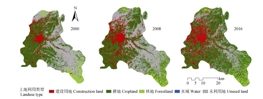
图12000—2016年榆次区土地利用现状图
Figure1.Land use changes in Yuci District from 2000 to 2016
 下载: 全尺寸图片幻灯片
表1研究区不同地形因子分级、面积及面积百分比
Table1.Areas and area percentages of topographic factors in different classification groups in the study area of Yuci District
| 地形因子 Topographic factor | 分级 Classification | 面积 Area (km2) | 面积比例 Area proportion (%) | ||
| 地形起伏度 Landform relief (m) | 0~30 | 541.55 | 41.37 | ||
| 30~70 | 477.91 | 36.50 | |||
| > 70 | 289.73 | 22.13 | |||
| 坡度变率 Slope change rate (°) | 0~2 | 436.20 | 33.32 | ||
| 2~6 | 611.50 | 46.71 | |||
| 6~15 | 250.63 | 19.14 | |||
| 15~25 | 10.52 | 0.80 | |||
| 25~35 | 0.34 | 0.03 | |||
| > 35 | 0.01 | 0.00 | |||
| 坡向 Aspect (°) | 平地Flat land (-1~0) | 21.60 | 1.65 | ||
| 阴坡Shady slope (0~45, 315~360) | 284.78 | 21.75 | |||
| 半阴坡Semi-shady slope (45~90, 270~315) | 316.92 | 24.21 | |||
| 半阳坡Semi-sunny slope (90~135, 225~270) | 330.11 | 25.21 | |||
| 阳坡Sunny slope (135~225) | 355.79 | 27.18 | |||
| 地形位 Terrain niche | 低 Low | 1 | 0.56~0.71 | 54.18 | 32.80 |
| 2 | 0.71~0.87 | 179.13 | |||
| 3 | 0.87~1.03 | 196.13 | |||
| 4 | 1.03~1.18 | 167.14 | |||
| 中低 Mid-low | 5 | 1.18~1.34 | 142.25 | 42.46 | |
| 6 | 1.34~1.50 | 128.50 | |||
| 7 | 1.50~1.65 | 118.00 | |||
| 中高 Mid-high | 8 | 1.65~1.81 | 111.01 | 23.54 | |
| 9 | 1.81~1.97 | 95.05 | |||
| 10 | 1.97~2.12 | 67.10 | |||
| 11 | 2.12~2.28 | 35.03 | |||
| 高 High | 12 | 2.28~2.43 | 12.40 | 1.20 | |
| 13 | 2.43~2.59 | 2.74 | |||
| 14 | 2.59~2.75 | 0.50 | |||
| 15 | 2.75~2.90 | 0.04 | |||
下载: 导出CSV表22000—2016年榆次区土地利用转移矩阵
Table2.Transfer matrix of land use types in Yuci District from 2000 to 2016 ?
| 转移矩阵 Transfer matrix | 2016年Year 2016 | 2000年合计 Sum in 2000 | 2000年转移量 Transfer amount in 2000 | |||||
| 建设用地 Construction land | 耕地 Crop land | 林地 Forest land | 水域 Water | 未利用地 Unused land | ||||
| 2000年 Year 2000 | 建设用地Construction land | 90.82 | 15.95 | 1.25 | 0.66 | 20.23 | 128.91 | 38.09 |
| 耕地Crop land | 80.14 | 428.20 | 1.50 | 0.60 | 48.55 | 558.99 | 130.79 | |
| 林地Forest land | 0.58 | 10.86 | 64.28 | 0.10 | 3.25 | 79.07 | 14.79 | |
| 水域Water | 0.36 | 0.09 | 0.03 | 0.74 | 0.08 | 1.30 | 0.56 | |
| 未利用地Unused land | 37.44 | 271.94 | 20.69 | 0.37 | 210.49 | 540.93 | 330.44 | |
| 2016年合计Sum in 2016 | 209.34 | 727.04 | 87.75 | 2.47 | 282.60 | 1 309.20 | ||
| 2016年增量Increment in 2016 | 118.52 | 298.84 | 23.47 | 1.73 | 72.11 | 514.67 | ||
下载: 导出CSV表32000—2016年榆次区土地利用变化情况
Table3.Land use change in Yuci District from 2000 to 2016
| 土地利用类型 Land use type | 2000年Year 2000 | 2008年Year 2008 | 2016年Year 2016 | 面积变化Area change (km2) | |||||||
| 面积 Area (km2) | 比例 Proportion (%) | 面积 Area (km2) | 比例 Proportion (%) | 面积 Area (km2) | 比例 Proportion (%) | 2000-2008 | 2008-2016 | ||||
| 建设用地Construction land | 128.91 | 9.85 | 171.98 | 13.14 | 209.34 | 15.99 | 43.07 | 37.36 | |||
| 耕地Crop land | 558.99 | 42.70 | 556.43 | 42.50 | 727.04 | 55.53 | -2.56 | 170.61 | |||
| 林地Forest land | 79.07 | 6.04 | 75.85 | 5.79 | 87.75 | 6.70 | -3.22 | 11.90 | |||
| 水域Water | 1.30 | 0.09 | 1.34 | 0.10 | 2.47 | 0.19 | 0.04 | 1.13 | |||
| 未利用地Unused land | 540.93 | 41.32 | 503.60 | 38.47 | 282.60 | 21.59 | -37.33 | -221.00 | |||
下载: 导出CSV表42000—2016年榆次区土地利用类型的地形起伏度梯度差异
Table4.Landform relief gradient difference of land use types in Yuci District during 2000—2016
| 土地利用类型 Land use type | 年份 Year | 地形起伏度Landform relief (m) | ||||||
| 0~30 | 30~70 | >70 | 0~30 | 30~70 | >70 | |||
| 面积、面积变化量Area, area change (km2) | 分布指数Distribution index | |||||||
| 建设用地 Construction land | 2000 | 98.74 | 26.37 | 3.79 | 1.88 | 0.54 | 0.14 | |
| 2008 | 142.47 | 27.14 | 2.35 | 2.03 | 0.43 | 0.06 | ||
| 2016 | 161.97 | 40.62 | 6.72 | 1.89 | 0.52 | 0.15 | ||
| 2000—2008 | 43.73 | 0.77 | -1.44 | |||||
| 2008—2016 | 19.50 | 13.48 | 4.37 | |||||
| 耕地 Crop land | 2000 | 369.80 | 158.58 | 30.50 | 1.61 | 0.76 | 0.23 | |
| 2008 | 317.87 | 160.97 | 77.46 | 1.39 | 0.78 | 0.64 | ||
| 2016 | 316.63 | 273.15 | 137.08 | 1.06 | 1.02 | 0.86 | ||
| 2000—2008 | -51.93 | 2.39 | 46.96 | |||||
| 2008—2016 | -1.24 | 112.18 | 59.62 | |||||
| 林地 Forest land | 2000 | 0.12 | 16.95 | 61.96 | 0 | 0.58 | 3.56 | |
| 2008 | 0.22 | 16.74 | 58.85 | 0.01 | 0.60 | 3.55 | ||
| 2016 | 1.02 | 20.26 | 66.44 | 0.03 | 0.62 | 3.44 | ||
| 2000—2008 | 0.10 | -0.21 | -3.11 | |||||
| 2008—2016 | 0.80 | 3.52 | 7.59 | |||||
| 水域 Water | 2000 | 0.28 | 0.44 | 0.33 | 0.54 | 0.91 | 1.14 | |
| 2008 | 0.41 | 0.45 | 0.23 | 0.76 | 0.91 | 0.77 | ||
| 2016 | 1.13 | 0.74 | 0.31 | 1.12 | 0.81 | 0.57 | ||
| 2000—2008 | 0.13 | 0.01 | -0.1 | |||||
| 2008—2016 | 0.72 | 0.29 | 0.08 | |||||
| 未利用地 Unused land | 2000 | 72.44 | 275.34 | 193.02 | 0.32 | 1.38 | 1.64 | |
| 2008 | 80.40 | 272.37 | 150.70 | 0.39 | 1.46 | 1.36 | ||
| 2016 | 60.59 | 142.89 | 79.04 | 0.52 | 1.37 | 1.27 | ||
| 2000—2008 | 7.96 | -2.97 | -42.32 | |||||
| 2008—2016 | -19.81 | -129.48 | -71.66 | |||||
下载: 导出CSV表52000—2016年榆次区土地利用类型的坡度变率梯度差异
Table5.Gradient difference of slope change rate of land use types in Yuci District during 2000—2016
| 土地利用类型 Land use type | 年份 Year | 坡度变率Slope change rate (°) | ||||||||||||
| 0~2 | 2~6 | 6~15 | 15~25 | 25~35 | >35 | 0~2 | 2~6 | 6~15 | 15~25 | 25~35 | >35 | |||
| 面积、面积变化量Area, area change (km2) | 分布指数Distribution index | |||||||||||||
| 建设用地 Construction land | 2000 | 74.23 | 47.06 | 7.31 | 0.36 | 0.03 | 0.00 | 1.73 | 0.78 | 0.30 | 0.35 | 0.90 | 0.00 | |
| 2008 | 103.11 | 60.83 | 7.42 | 0.54 | 0.06 | 0.00 | 1.80 | 0.78 | 0.23 | 0.39 | 1.34 | 0.00 | ||
| 2016 | 115.45 | 78.59 | 14.25 | 0.94 | 0.07 | 0.00 | 1.66 | 0.80 | 0.36 | 0.55 | 1.29 | 0.00 | ||
| 2000—2008 | 28.88 | 13.77 | 0.11 | 0.18 | 0.03 | 0.00 | ||||||||
| 2008—2016 | 12.34 | 17.76 | 6.83 | 0.40 | 0.01 | 0.00 | ||||||||
| 耕地 Crop land | 2000 | 248.62 | 245.22 | 61.78 | 3.42 | 0.17 | 0.00 | 1.34 | 0.94 | 0.57 | 0.75 | 1.17 | 0.00 | |
| 2008 | 218.86 | 248.22 | 84.57 | 4.37 | 0.16 | 0.00 | 1.18 | 0.95 | 0.79 | 0.97 | 1.11 | 0.00 | ||
| 2016 | 244.42 | 346.81 | 129.83 | 5.51 | 0.15 | 0.00 | 1.01 | 1.02 | 0.93 | 0.94 | 0.80 | 0.00 | ||
| 2000—2008 | -29.76 | 3 | 22.79 | 0.95 | -0.01 | 0.00 | ||||||||
| 2008—2016 | 25.56 | 98.59 | 45.26 | 1.14 | -0.01 | 0.00 | ||||||||
| 林地 Forest land | 2000 | 7.97 | 36.78 | 32.67 | 1.61 | 0.02 | 0.00 | 0.30 | 0.99 | 2.16 | 2.51 | 0.97 | 0.00 | |
| 2008 | 7.67 | 35.42 | 31.16 | 1.51 | 0.02 | 0.00 | 0.30 | 1.00 | 2.15 | 2.46 | 1.02 | 0.00 | ||
| 2016 | 9.22 | 40.56 | 36.17 | 1.71 | 0.03 | 0.00 | 0.32 | 0.99 | 2.15 | 2.41 | 1.32 | 0.00 | ||
| 2000—2008 | -0.3 | -1.36 | -1.51 | -0.1 | 0.00 | 0.00 | ||||||||
| 2008—2016 | 1.55 | 5.14 | 5.01 | 0.20 | 0.01 | 0.00 | ||||||||
| 水域 Water | 2000 | 0.23 | 0.46 | 0.30 | 0.01 | 0.00 | 0.00 | 0.53 | 0.76 | 1.21 | 0.95 | 0.00 | 0.00 | |
| 2008 | 0.34 | 0.51 | 0.19 | 0.00 | 0.00 | 0.00 | 0.76 | 0.81 | 0.74 | 0.00 | 0.00 | 0.00 | ||
| 2016 | 0.86 | 0.90 | 0.38 | 0.01 | 0.00 | 0.00 | 1.05 | 0.78 | 0.80 | 0.50 | 0.00 | 0.00 | ||
| 2000—2008 | 0.11 | 0.05 | -0.11 | -0.01 | 0.00 | 0.00 | ||||||||
| 2008—2016 | 0.52 | 0.38 | 0.19 | 0.01 | 0.00 | 0.00 | ||||||||
| 未利用地 Unused land | 2000 | 105.04 | 282.17 | 148.60 | 5.24 | 0.12 | 0.00 | 0.58 | 1.12 | 1.44 | 1.20 | 0.85 | 0.00 | |
| 2008 | 105.77 | 266.22 | 127.11 | 4.20 | 0.10 | 0.00 | 0.63 | 1.13 | 1.32 | 1.03 | 0.77 | 0.00 | ||
| 2016 | 65.78 | 144.33 | 69.82 | 2.46 | 0.08 | 0.00 | 0.70 | 1.09 | 1.29 | 1.07 | 1.09 | 0.00 | ||
| 2000—2008 | 0.73 | -15.95 | -21.49 | -1.04 | -0.02 | 0.00 | ||||||||
| 2008—2016 | -39.99 | -121.89 | -57.29 | -1.74 | -0.02 | 0.00 | ||||||||
下载: 导出CSV表62000—2016年榆次区土地利用类型的坡向梯度差异
Table6.Aspect gradient difference of land use types in Yuci District during 2000—2016
| 土地利用类型 Land use type | 年份 Year | 坡向Aspect | ||||||||||
| 平地 Flat land | 阴坡 Shady slope | 半阴坡 Semi-shady slope | 半阳坡 Semi-sunny slope | 阳坡 Sunny slope | 平地 Flat land | 阴坡 Shady slope | 半阴坡 Semi-shady slope | 半阳坡 Semi-sunny slope | 阳坡 Sunny slope | |||
| 面积、面积变化量Area, area change (km2) | 分布指数Distribution index | |||||||||||
| 建设用地 Construction land | 2000 | 3.68 | 24.07 | 31.00 | 34.87 | 35.35 | 1.76 | 0.75 | 0.99 | 1.07 | 1.01 | |
| 2008 | 5.45 | 32.15 | 39.06 | 46.01 | 49.27 | 1.92 | 0.86 | 0.94 | 1.06 | 1.05 | ||
| 2016 | 6.21 | 39.93 | 48.06 | 55.11 | 59.99 | 1.80 | 0.88 | 0.95 | 1.05 | 1.05 | ||
| 2000—2008 | 1.77 | 8.08 | 8.06 | 11.14 | 13.92 | |||||||
| 2008—2016 | 0.76 | 7.78 | 9.00 | 9.10 | 10.72 | |||||||
| 耕地 Crop land | 2000 | 13.76 | 118.95 | 127.54 | 138.77 | 160.18 | 1.49 | 0.98 | 0.94 | 0.99 | 1.05 | |
| 2008 | 12.25 | 121.86 | 128.34 | 137.72 | 156.02 | 1.33 | 1.01 | 0.95 | 0.98 | 1.03 | ||
| 2016 | 12.35 | 146.87 | 166.28 | 186.33 | 214.90 | 1.03 | 0.93 | 0.95 | 1.02 | 1.09 | ||
| 2000—2008 | -1.51 | 2.91 | 0.80 | -1.05 | -4.16 | |||||||
| 2008—2016 | 0.10 | 25.01 | 37.94 | 48.61 | 58.88 | |||||||
| 林地 Forest land | 2000 | 0.40 | 31.79 | 28.23 | 12.98 | 5.67 | 0.31 | 1.85 | 1.48 | 0.65 | 0.26 | |
| 2008 | 0.40 | 31.67 | 27.17 | 11.86 | 4.70 | 0.32 | 1.92 | 1.48 | 0.62 | 0.23 | ||
| 2016 | 0.47 | 38.27 | 30.70 | 13.00 | 5.27 | 0.32 | 2.01 | 1.45 | 0.59 | 0.22 | ||
| 2000—2008 | 0.00 | -0.12 | -1.06 | -1.12 | -0.97 | |||||||
| 2008—2016 | 0.07 | 6.60 | 3.53 | 1.14 | 0.57 | |||||||
| 水域 Water | 2000 | 0.01 | 0.18 | 0.33 | 0.24 | 0.25 | 0.47 | 0.64 | 1.05 | 0.73 | 0.71 | |
| 2008 | 0.02 | 0.25 | 0.29 | 0.24 | 0.24 | 0.90 | 0.86 | 0.89 | 0.71 | 0.66 | ||
| 2016 | 0.04 | 0.45 | 0.55 | 0.53 | 0.57 | 0.98 | 0.84 | 0.92 | 0.85 | 0.85 | ||
| 2000—2008 | 0.01 | 0.07 | -0.04 | 0.00 | -0.01 | |||||||
| 2008—2016 | 0.02 | 0.20 | 0.26 | 0.29 | 0.33 | |||||||
| 未利用地 Unused land | 2000 | 3.91 | 109.84 | 129.83 | 143.24 | 154.35 | 0.44 | 0.93 | 0.99 | 1.05 | 1.05 | |
| 2008 | 3.62 | 98.67 | 121.81 | 134.01 | 145.28 | 0.44 | 0.90 | 1.00 | 1.06 | 1.06 | ||
| 2016 | 2.68 | 59.09 | 71.09 | 74.86 | 74.78 | 0.57 | 0.96 | 1.04 | 1.05 | 0.97 | ||
| 2000—2008 | -0.29 | -11.17 | -8.02 | -9.23 | -9.07 | |||||||
| 2008—2016 | -0.94 | -39.58 | -50.72 | -59.15 | -70.50 | |||||||
下载: 导出CSV表72000—2016年榆次区土地利用类型的地形位梯度差异
Table7.Terrain niche gradient difference of land use types in Yuci District during 2000—2016
| 土地利用类型 Land use type | 年份 Year | 地形位Terrain niche | ||||||||
| 低 Low(1~3 level) | 中低 Mid-low (4~7 level) | 中高 Mid-high(8~11 level) | 高 High(12~15 level) | 低 Low(1~3 level) | 中低 Mid-low(4~7 level) | 中高 Mid-high(8~11 level) | 高 High(12~15 level) | |||
| 面积、面积变化量Area, area change (km2) | 分布指数Distribution index | |||||||||
| 建设用地 Construction land | 2000 | 81.78 | 41.35 | 5.57 | 0.18 | 1.93 | 0.75 | 0.18 | 0.12 | |
| 2008 | 119.01 | 50.05 | 2.78 | 0.11 | 2.11 | 0.68 | 0.07 | 0.05 | ||
| 2016 | 133.91 | 67.02 | 8.22 | 0.14 | 1.95 | 0.75 | 0.17 | 0.06 | ||
| 2000—2008 | 37.23 | 8.70 | -2.79 | -0.07 | ||||||
| 2008—2016 | 14.90 | 16.97 | 5.44 | 0.03 | ||||||
| 耕地 Crop land | 2000 | 284.00 | 235.45 | 38.36 | 0.94 | 1.55 | 0.99 | 0.29 | 0.14 | |
| 2008 | 243.76 | 224.11 | 83.01 | 5.28 | 1.34 | 0.95 | 0.63 | 0.79 | ||
| 2016 | 243.30 | 329.48 | 147.82 | 6.12 | 1.02 | 1.07 | 0.86 | 0.70 | ||
| 2000—2008 | -40.24 | -11.34 | 44.65 | 4.34 | ||||||
| 2008—2016 | -0.46 | 105.37 | 64.81 | 0.84 | ||||||
| 林地 Forest land | 2000 | 0.35 | 12.81 | 57.91 | 7.92 | 0.01 | 0.38 | 3.11 | 8.35 | |
| 2008 | 0.32 | 12.49 | 55.63 | 7.36 | 0.01 | 0.39 | 3.12 | 8.09 | ||
| 2016 | 0.98 | 14.85 | 64.07 | 7.78 | 0.03 | 0.40 | 3.10 | 7.39 | ||
| 2000—2008 | -0.03 | -0.32 | -2.28 | -0.56 | ||||||
| 2008—2016 | 0.66 | 2.36 | 8.44 | 0.42 | ||||||
| 水域 Water | 2000 | 0.27 | 0.51 | 0.21 | 0.01 | 0.63 | 0.92 | 0.69 | 0.64 | |
| 2008 | 0.41 | 0.49 | 0.14 | 0.00 | 0.93 | 0.86 | 0.44 | 0.00 | ||
| 2016 | 1.00 | 0.87 | 0.24 | 0.01 | 1.23 | 0.83 | 0.41 | 0.34 | ||
| 2000—2008 | 0.14 | -0.02 | -0.07 | -0.01 | ||||||
| 2008—2016 | 0.59 | 0.38 | 0.10 | 0.01 | ||||||
| 未利用地 Unused land | 2000 | 62.48 | 265.28 | 206.34 | 6.62 | 0.35 | 1.15 | 1.62 | 1.02 | |
| 2008 | 65.37 | 268.28 | 166.81 | 2.92 | 0.40 | 1.25 | 1.41 | 0.48 | ||
| 2016 | 49.67 | 143.20 | 88.02 | 1.62 | 0.54 | 1.19 | 1.32 | 0.48 | ||
| 2000—2008 | 2.89 | 3.00 | -39.53 | -3.70 | ||||||
| 2008—2016 | -15.70 | -125.08 | -78.79 | -1.30 | ||||||
下载: 导出CSV参考文献
| [1] | 孙丕苓, 许月卿, 王数.环京津贫困带土地利用变化的地形梯度效应分析[J].农业工程学报, 2014, 30(14):277-288 http://www.wanfangdata.com.cn/details/detail.do?_type=perio&id=nygcxb201414035 SUN P L, XU Y Q, WANG S. Terrain gradient effect analysis of land use change in poverty area around Beijing and Tianjin[J]. Transactions of the Chinese Society of Agricultural Engineering, 2014, 30(14):277-288 http://www.wanfangdata.com.cn/details/detail.do?_type=perio&id=nygcxb201414035 |
| [2] | 李京京, 吕哲敏, 石小平, 等.基于地形梯度的汾河流域土地利用时空变化分析[J].农业工程学报, 2016, 32(7):230-236 http://www.wanfangdata.com.cn/details/detail.do?_type=perio&id=nygcxb201607032 LI J J, LYU Z M, SHI X P, et al. Spatiotemporal variations analysis for land use in Fen River Basin based on terrain gradient[J]. Transactions of the Chinese Society of Agricultural Engineering, 2016, 32(7):230-236 http://www.wanfangdata.com.cn/details/detail.do?_type=perio&id=nygcxb201607032 |
| [3] | 余正军, 任志远, 卢锦容, 等.基于地形综合指数的土地利用动态变化研究——以山西省运城市为例[J].宁夏大学学报:自然科学版, 2013, 34(3):270-274 http://www.wanfangdata.com.cn/details/detail.do?_type=perio&id=nxdxxb201303019 YU Z J, REN Z Y, LU J R, et al. Study on land use dynamic changes based on the topographic composite index-Take the Yuncheng for example[J]. Journal of Ningxia University:Natural Science Edition, 2013, 34(3):270-274 http://www.wanfangdata.com.cn/details/detail.do?_type=perio&id=nxdxxb201303019 |
| [4] | RADOSLAVA K, KIZEKOVá M, NOVá ?EK J, et al. Land-use and land-cover changes in rural areas during different political systems:A case study of Slovakia from 1782 to 2006[J]. Land Use Policy, 2014, 36:554-566 doi: 10.1016/j.landusepol.2013.09.018 |
| [5] | 毛蒋兴, 闫小培.中国城市土地快速变化的特征与机制——以深圳为例[M].南京:南京大学出版社, 2009 MAO J X, YAN X P. Characteristics and Mechanism of Rapid Change of Urban Land in China:A Case Study of Shenzhen[M]. Nanjing:Nanjing University Press, 2009 |
| [6] | 郜红娟, 张朝琼, 张凤太.基于地形梯度的贵州省土地利用时空变化分析[J].四川农业大学学报, 2015, 33(1):62-70 http://www.wanfangdata.com.cn/details/detail.do?_type=perio&id=scnydxxb201501011 GAO H J, ZHANG C Q, ZHANG F T. Spatio-temporal patterns of land use change in Guizhou Province based on terrain gradient[J]. Journal of Sichuan Agricultural University, 2015, 33(1):62-70 http://www.wanfangdata.com.cn/details/detail.do?_type=perio&id=scnydxxb201501011 |
| [7] | 毛蒋兴, 李志刚, 闫小培, 等.深圳土地利用时空变化与地形因子的关系研究[J].地理与地理信息科学, 2008, 24(2):71-76 http://www.wanfangdata.com.cn/details/detail.do?_type=perio&id=dlxygtyj200802018 MAO J X, LI Z G, YAN X P, et al. Research on the spatio-temporal changes of land use in relation to topography factors in Shenzhen City[J]. Geography and Geo-Information Science, 2008, 24(2):71-76 http://www.wanfangdata.com.cn/details/detail.do?_type=perio&id=dlxygtyj200802018 |
| [8] | 武爱彬, 刘欣, 赵艳霞.地形因子对浅山丘陵区土地利用类型分布与转换的影响——以燕山浅山丘陵区为例[J].农业现代化研究, 2014, 35(1):103-107 http://www.wanfangdata.com.cn/details/detail.do?_type=perio&id=CASS_48675847 WU A B, LIU X, ZHAO Y X. Influences of topographic on distribution and change of land use types in hilly region-Taking Yanshan hilly region as an example[J]. Research of Agricultural modernization, 2014, 35(1):103-107 http://www.wanfangdata.com.cn/details/detail.do?_type=perio&id=CASS_48675847 |
| [9] | 崔步礼, 李小雁, 姜广辉, 等.基于DEM的山地丘陵区土地利用/覆被研究——以青海湖流域为例[J].自然资源学报, 2011, 26(5):871-880 http://www.wanfangdata.com.cn/details/detail.do?_type=perio&id=zrzyxb201105014 CUI B L, LI X Y, JIANG G H, et al. Study on land use/cover in mountain area based on the DEM-Taking the Qinghai Lake basin as an example[J]. Journal of Natural Resources, 2011, 26(5):871-880 http://www.wanfangdata.com.cn/details/detail.do?_type=perio&id=zrzyxb201105014 |
| [10] | 龚文峰, 袁力, 范文义.基于地形梯度的哈尔滨市土地利用格局变化分析[J].农业工程学报, 2013, 29(2):250-259 http://www.wanfangdata.com.cn/details/detail.do?_type=perio&id=nygcxb201302034 GONG W F, YUAN L, FAN W Y. Analysis on land use pattern changes in Harbin based on terrain gradient[J]. Transactions of the Chinese Society of Agricultural Engineering, 2013, 29(2):250-259 http://www.wanfangdata.com.cn/details/detail.do?_type=perio&id=nygcxb201302034 |
| [11] | 吴见, 张艳, 谭靖, 等.安徽省土地利用地形梯度格局变化分析[J].遥感信息, 2016, 31(4):108-115 http://www.wanfangdata.com.cn/details/detail.do?_type=perio&id=ygxx201604017 WU J, ZHANG Y, TAN J, et al. Analysis on land use terrain gradient pattern changes in Anhui Province[J]. Remote Sensing Information, 2016, 31(4):108-115 http://www.wanfangdata.com.cn/details/detail.do?_type=perio&id=ygxx201604017 |
| [12] | 李靖, 廖和平, 蔡进, 等.山地城市边缘土地利用格局与变化的地形梯度分布特征分析——以重庆市巴南区为例[J].长江流域资源与环境, 2018, 27(2):296-305 http://www.wanfangdata.com.cn/details/detail.do?_type=perio&id=cjlyzyyhj201802008 LI J, LIAO H P, CAI J, et al. Distribution characteristic on terrain gradient of land use pattern and change in the fringe of mountainous cities:A case study of Banan District in Chongqing[J]. Resources and Environment in the Yangtze Basin, 2018, 27(2):296-305 http://www.wanfangdata.com.cn/details/detail.do?_type=perio&id=cjlyzyyhj201802008 |
| [13] | LI Z, LIU W Z, ZHENG F L. The land use changes and its relationship with topographic factors in the Jing river catchment on the Loess Plateau of China[J]. SpringerPlus, 2013, 2(1):1-6 doi: 10.1186/2193-1801-2-1 |
| [14] | 董顺舟, 赵宇鸾, 李秀彬.基于地形梯度的高原山地区土地利用格局时空特征——以贵州省盘县为例[J].水土保持研究, 2017, 24(2):213-222 http://www.wanfangdata.com.cn/details/detail.do?_type=perio&id=stbcyj201702037 DONG S Z, ZHAO Y L, LI X B. Spatiotemporal patterns of land use change in plateau region based on the terrain gradient-A case study in Panxian County, Guizhou Province[J]. Research of Soil and Water Conservation, 2017, 24(2):213-222 http://www.wanfangdata.com.cn/details/detail.do?_type=perio&id=stbcyj201702037 |
| [15] | BIRHANU L, HAILU B T, BEKELE T, et al. Land use/land cover change along elevation and slope gradient in highlands of Ethiopia[J]. Remote Sensing Applications:Society and Environment, 2019, 16:100260 doi: 10.1016/j.rsase.2019.100260 |
| [16] | 陈颐, 林毅伟, 朱志鹏, 等.莆田市土地利用格局的地形梯度特征变化及尺度效应[J].安徽农业大学学报, 2017, 44(1):102-107 http://www.wanfangdata.com.cn/details/detail.do?_type=perio&id=ahnydxxb201701017 CHEN Y, LIN Y W, ZHU Z P, et al. Characteristic change and scaling effect of the land use pattern in Putian City based on the terrain gradient[J]. Journal of Anhui Agricultural University, 2017, 44(1):102-107 http://www.wanfangdata.com.cn/details/detail.do?_type=perio&id=ahnydxxb201701017 |
| [17] | 许宁, 张广录, 刘紫玉.基于地形梯度的河北省太行山区土地利用时空变异研究[J].中国生态农业学报, 2013, 21(10):1284-1292 http://www.ecoagri.ac.cn/zgstny/ch/reader/view_abstract.aspx?file_no=20131015&flag=1 XU N, ZHANG G L, LIU Z Y. Spatial-temporal variability of land use with terrain gradient in Taihang Mountain, Hebei Province[J]. Chinese Journal of Eco-Agriculture, 2013, 21(10):1284-1292 http://www.ecoagri.ac.cn/zgstny/ch/reader/view_abstract.aspx?file_no=20131015&flag=1 |
| [18] | 范双云.基于地形梯度的环洞庭湖区土地利用格局变化分析[D].长沙: 湖南师范大学, 2014 FAN S Y. Analysis on land use pattern changes in pan-Dongting lake area based on terrain gradient[D]. Changsha: Hunan Normal University, 2014 |
| [19] | 薄广涛, 牛志君, 郭义强, 等.冀西北间山盆地区土地利用变化地形梯度效应——以河北省怀来县为例[J].水土保持研究, 2017, 24(1):226-231 http://www.wanfangdata.com.cn/details/detail.do?_type=perio&id=stbcyj201701038 BO G T, NIU Z J, GUO Y Q, et al. Effect of terrain gradient on land use change in basin of mountains typical district in Northwestern Hebei-A case study in Huailai County[J]. Research of Soil and Water Conservation, 2017, 24(1):226-231 http://www.wanfangdata.com.cn/details/detail.do?_type=perio&id=stbcyj201701038 |
| [20] | WU X P, TANG Z Y, CUI H T, et al. Land cover dynamics of different topographic conditions in Beijing, China[J]. Frontiers of Biology in China, 2007, 2(4):463-473 doi: 10.1007/s11515-007-0071-x |
| [21] | 臧玉珠, 刘彦随, 杨园园.山区县域土地利用格局变化及其地形梯度效应——以井冈山市为例[J].自然资源学报, 2019, 34(7):1391-1404 http://www.cnki.com.cn/Article/CJFDTotal-ZRZX201907004.htm ZANG Y Z, LIU Y S, YANG Y Y. Land use pattern change and its topographic gradient effect in the mountainous areas:A case study of Jinggangshan City[J]. Journal of Natural Resources, 2019, 34(7):1391-1404 http://www.cnki.com.cn/Article/CJFDTotal-ZRZX201907004.htm |
| [22] | BIRHANE E, ASHFARE H, FENTA A A, et al. Land use land cover changes along topographic gradients in Hugumburda national forest priority area, Northern Ethiopia[J]. Remote Sensing Applications:Society and Environment, 2019, 13:61-68 doi: 10.1016/j.rsase.2018.10.017 |
| [23] | QASIM M, HUBACEK K, TERMANSEN M, et al. Modelling land use change across elevation gradients in district Swat, Pakistan[J]. Regional Environmental Change, 2013, 13(3):567-581 doi: 10.1007/s10113-012-0395-1 |
| [24] | LU L, GUO L, ZHAO S T. Land use and land cover change on slope in Qiandongnan prefecture of southwest China[J]. Journal of Mountain Science, 2014, 11(3):762-773 doi: 10.1007/s11629-012-2570-8 |
| [25] | 白希选, 严翼.武陵山区地形起伏度特征及其与土地利用的变化关系[J].武汉工程大学学报, 2020, 42(1):73-78 http://www.wanfangdata.com.cn/details/detail.do?_type=perio&id=whhgxyxb202001012 BAI X X, YAN Y. Characteristics of topographic relief amplitude and its relationship with land use change in Wuling mountainous area[J]. Journal of Wuhan Institute of Technology, 2020, 42(1):73-78 http://www.wanfangdata.com.cn/details/detail.do?_type=perio&id=whhgxyxb202001012 |
| [26] | 陈学兄, 常庆瑞, 郭碧云, 等.基于SRTM DEM数据的中国地形起伏度分析研究[J].应用基础与工程科学学报, 2013, 21(4):670-678 http://www.wanfangdata.com.cn/details/detail.do?_type=perio&id=yyjcygckxxb201304009 CHEN X X, CHANG Q R, GUO B Y, et al. Analytical study of the relief amplitude in China based on SRTM Dem data[J]. Journal of Basic Science and Engineering, 2013, 21(4):670-678 http://www.wanfangdata.com.cn/details/detail.do?_type=perio&id=yyjcygckxxb201304009 |
| [27] | 陈学兄, 常庆瑞, 毕如田, 等.地形起伏度最佳统计单元算法的比较研究[J].水土保持研究, 2018, 25(1):52-56 http://www.wanfangdata.com.cn/details/detail.do?_type=perio&id=stbcyj201801010 CHEN X X, CHANG Q R, BI R T, et al. Comparison study on the best statistical unit algorithms of relief amplitude[J]. Research of Soil and Water Conservation, 2018, 25(1):52-56 http://www.wanfangdata.com.cn/details/detail.do?_type=perio&id=stbcyj201801010 |
| [28] | 陈奕竹, 肖轶, 孙思琦, 等.基于地形梯度的湘西地区生态系统服务价值时空变化[J].中国生态农业学报(中英文), 2019, 27(4):623-631 http://www.ecoagri.ac.cn/zgstny/ch/reader/view_abstract.aspx?file_no=2019-0413&flag=1 CHEN Y Z, XIAO Y, SUN S Q, et al. Spatial-temporal changes of ecosystem service values in Xiangxi region based on terrain[J]. Chinese Journal of Eco-Agriculture, 2019, 27(4):623-631 http://www.ecoagri.ac.cn/zgstny/ch/reader/view_abstract.aspx?file_no=2019-0413&flag=1 |
| [29] | 刘京, 陈涛, 常庆瑞, 等.渭北旱塬县域土地利用时空演变规律研究——以合阳县为例[J].中国生态农业学报, 2016, 24(11):1565-1574 http://www.ecoagri.ac.cn/zgstny/ch/reader/view_abstract.aspx?file_no=20161115&flag=1 LIU J, CHEN T, CHANG Q R, et al. Land use dynamics in Weibei upland in China-A case study of Heyang County[J]. Chinese Journal of Eco-Agriculture, 2016, 24(11):1565-1574 http://www.ecoagri.ac.cn/zgstny/ch/reader/view_abstract.aspx?file_no=20161115&flag=1 |
| [30] | DEMISSIE F, YESHITILA K, KINDU M, et al. Land use/Land cover changes and their causes in Libokemkem District of South Gonder, Ethiopia[J]. Remote Sensing Applications:Society and Environment, 2017, 8:224-230 doi: 10.1016/j.rsase.2017.10.001 |
