李欢1,
艾宁2,
黄涛1,
顾继升1
1.宁夏回族自治区遥感测绘勘查院(宁夏回族自治区遥感中心) 银川 750000
2.宁夏回族自治区应急宣传教育中心 银川 750001
基金项目: 宁夏回族自治区重点研发计划一般项目2018BEG03069
详细信息
通讯作者:武丹, 主要从事遥感监测与研究工作。E-mail:wudannever@qq.com
中图分类号:F124.5;X24计量
文章访问数:177
HTML全文浏览量:11
PDF下载量:114
被引次数:0
出版历程
收稿日期:2020-03-26
录用日期:2020-04-27
刊出日期:2020-12-01
Predicting spatiotemporal changes in land use and habitat quality based on CA-Markov: A case study in central Ningxia, China
WU Dan1,,,LI Huan1,
AI Ning2,
HUANG Tao1,
GU Jisheng1
1. Remote Sensing Mapping and Surveying Institute of Ningxia Hui Autonomous Region(Remote Sensing Center of Ningxia Hui Autonomous Region), Yinchuan 750000, China
2. Emergency Publicity and Education Center of Ningxia Hui Autonomous Region, Yinchuan 750001, China
Funds: the Key R & D Program of Ningxia Hui Autonomous Region2018BEG03069
More Information
Corresponding author:WU Dan, E-mail:wudannever@qq.com
摘要
HTML全文
图
参考文献
相关文章
施引文献
资源附件
访问统计
摘要
摘要:探究干旱半干旱区土地利用结构动态变化特征,评估并预测生境质量,可为区域生态规划和恢复提供决策性依据。本研究以搭载OLI和ETM+传感器遥感影像和气象数据、社会经济数据等为基础,采用土地利用转移流概念、InVEST模型和CA-Markov模型研究2000-2030年宁夏中部干旱区土地利用和生境质量时空变化特征及规律,对未来情境进行模拟和预测。研究结果表明:宁夏中部干旱区土地系统结构变化与生态建设规划高度一致,具有黄河流域两侧集中分布的特征,土地系统综合动态度逐期减小,活跃度具有稳中有变、部分较活跃的特征。土地系统信息熵特征值呈逐年降低趋势。随着时间变化土地系统受人类活动干扰强度低,自我调整程度高,修复能力强,系统向稳定状态转化。2000-2015年研究区生态环境质量呈“U”型特征,以优秀等级为主。2015-2030年土地系统结构将发生显著变化,生境质量优秀、差和良好等级面积逐渐扩大,生态系统呈现稳定向好的趋势。本研究的多模型集成应用可为区域土地规划和生态恢复建设提供理论依据和支撑。
Abstract:The ecological impacts of land use have become a contested topic in ecological environmental research. An understanding of the land-use structure characteristics in arid and semi-arid areas allows for habitat quality assessment and prediction and provides a decision-making guide for regional ecological planning and restoration. Remote sensing apparatus equipped with an operational land imager and enhanced thematic mapper plus sensors, meteorological data, and socio-economic data were used to explore the temporal and spatial changes of land use and habitat quality in the arid area of central Ningxia, China, from 2000 to 2030. Land-use transfer flow, the InVEST model, and the CA-Markov model were used to simulate the habitat characteristics and laws and generate predictions. The land-use transfer flow, which explored the dynamic changes of the land system structure, showed significant results and explained the land-use transfer laws and spatial distribution characteristics. The land system structure changes were consistent with the ecological construction plan and had a concentrated distribution on both sides of the Yellow River basin. The land system's comprehensive dynamics gradually decreased and stabilized. The entropy value showed an annual downward trend, indicating that over time, with less human disturbances, the land can self-adjust and self-repair, creating a stable state. From 2000 to 2015, the ecological environment quality showed "U" shape characteristics, indicating an excellent habitat quality grade. From 2015 to 2030, the land system structure will undergo significant changes; the excellent, good, and poor habitat quality areas will gradually expand, and the ecosystem will stabilize and improve. The multi-model integration application can thus provide support for regional land planning and ecological restoration.
HTML全文

图12000-2015年宁夏中部干旱区土地利用变化图
Figure1.Maps of land use change in the arid regions of central Ningxia from 2000 to 2015
 下载: 全尺寸图片幻灯片
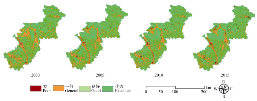
图2宁夏中部干旱区生境质量空间分布
Figure2.Spatial distribution of habitat quality in the arid regions of central Ningxia
下载: 全尺寸图片幻灯片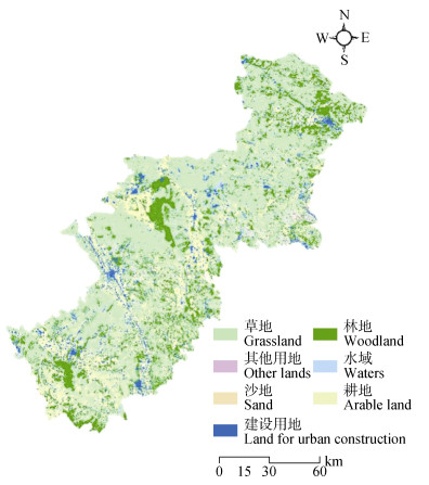
图3宁夏中部干旱区2030年土地利用预测图
Figure3.Forecast of land use in the arid regions of central Ningxia in 2030
下载: 全尺寸图片幻灯片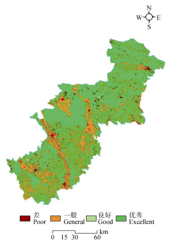
图4宁夏中部干旱区2030年生境质量预测图
Figure4.Prediction map of habitat quality in the arid regions of central Ningxia in 2030
下载: 全尺寸图片幻灯片表1生态胁迫因子属性表
Table1.Threat fader properties
| 胁迫因子 Stress factor | 最大影响距离 Maximum impact distance (km) | 权重 Weight | 距离递减率 Distance lapse rate |
| 农村居民地 Rural settlement | 5 | 0.2 | 1 |
| 工矿用地 Industrial land | 5 | 0.3 | 1 |
| 交通用地 Land for transportation | 10 | 0.4 | 1 |
| 水利设施用地 Land for water facilities | 5 | 0.1 | 1 |
| 城镇建设用地 Land for urban construction | 8 | 0.3 | 1 |
下载: 导出CSV表2不同土地利用类型的生境适宜性
Table2.Habitat suitabilities of different land use types
| 土地覆盖类型 Land cover type | 生境适宜性 Habitat suitability | 土地利用类型?Land use type | |||||
| 农村居民地 Rural residential areas | 城镇建设用地 Urban land | 工矿用地 Industrial and mining land | 交通用地 Traffic land | 水利设施用地 Water conservancy facility land | |||
| 林地?Woodland | 1 | 0.8 | 0.9 | 0.7 | 0.8 | 0.6 | |
| 草地?Grassland | 1 | 0.75 | 0.9 | 0.7 | 0.7 | 0.6 | |
| 沙地?Sand | 1 | 0.5 | 0.6 | 0.45 | 0.4 | 0.03 | |
| 其他用地?Other lands | 0.3 | 0.5 | 0.35 | 0.3 | 0.4 | 0.25 | |
| 水域?Waters | 1 | 0.5 | 0.6 | 0.3 | 0.4 | 0.5 | |
| 耕地?Arable land | 1 | 0.8 | 0.9 | 0.7 | 0.8 | 0.9 | |
| 建设用地 Construction land | 农村居民地?Rural settlement | 0 | 0 | 0 | 0 | 0 | 0 |
| 城镇建设用地 Land for urban construction | 0 | 0 | 0 | 0 | 0 | 0 | |
| 工矿用地?Industrial land | 0 | 0 | 0 | 0 | 0 | 0 | |
| 交通用地 Land for transportation | 0 | 0 | 0 | 0 | 0 | 0 | |
| 水利设施用地 Land for water facilities | 0 | 0 | 0 | 0 | 0 | 0 | |
下载: 导出CSV表32000-2015年宁夏中部干旱区土地利用动态度
Table3.Dynamic degrees of land use in the arid regions of central Ningxia from 2000 to 2015 ?
| 土地利用类型 Land use type | 2000-2005 | 2005-2010 | 2010-2015 | 2000-2015 | |
| 单一土地利用动态度 Dynamic degree of single land use | 草地?Grassland | 1.94 | 0.08 | 0.63 | 0.91 |
| 耕地?Arable land | -3.42 | -0.63 | -1.00 | -1.58 | |
| 建设用地?Land for urban construction | 2.35 | 3.84 | 2.50 | 3.32 | |
| 林地?Woodland | 4.47 | 1.01 | 0.19 | 1.98 | |
| 其他用地?Other lands | -1.77 | -1.03 | -1.89 | -1.45 | |
| 沙地?Sand | -8.15 | -4.13 | -3.73 | -4.12 | |
| 水域?Waters | 1.29 | 1.88 | -0.26 | 1.00 | |
| 综合利用动态度?Comprehensive dynamic degree of land use | 2.13 | 0.93 | 0.71 | 2.96 | |
下载: 导出CSV表42000-2015年宁夏中部干旱区主要土地利用类型动态度特征和土地信息熵
Table4.Dynamic characteristics of main land use types and information entropy of land in the arid regions of central Ningxia from 2000 to 2015
| 年份 Year | 土地利用类型动态度?Dynamic characteristics of land use (%) | 土地信息熵 Information entropy of land | ||||||
| 草地 Grassland | 耕地 Arable land | 建设用地 Land for urban construction | 林地 Woodland | 其他土地 Other lands | 沙地 Sand | 水域 Waters | ||
| 2000-2005 | 3.16 | 5.57 | 4.32 | 4.05 | 4.28 | 23.46 | 10.88 | 0.17 |
| 2005-2010 | 1.48 | 1.44 | 3.71 | 1.49 | 5.12 | 8.05 | 7.98 | 0.09 |
| 2010-2015 | 2.46 | 3.72 | 8.82 | 2.78 | 9.10 | 11.49 | 18.43 | 0.08 |
| 2000-2015 | 4.12 | 7.92 | 7.89 | 5.30 | 8.43 | 42.07 | 16.69 | 0.22 |
下载: 导出CSV表52000-2015年宁夏中部干旱区生境质量等级变化表
Table5.Habitat quality grade change table in the arid regions of central Ningxia from 2000 to 2015
| 生境质量等级 Habitat quality level | 2000 | 2005 | 2010 | 2015 | |||||||
| 面积 Area (km2) | 比例 Proportion (%) | 面积 Area (km2) | 比例 Proportion (%) | 面积 Area (km2) | 比例 Proportion (%) | 面积 Area (km2) | 比例 Proportion (%) | ||||
| 差?Poor | 484.32 | 2.59 | 518.32 | 2.77 | 639.64 | 3.42 | 694.92 | 3.71 | |||
| 一般?General | 6 169.65 | 32.97 | 5 132.98 | 27.43 | 4 949.24 | 26.45 | 4 721.34 | 25.23 | |||
| 良好?Good | 80.13 | 0.43 | 85.24 | 0.46 | 93.25 | 0.50 | 92.09 | 0.49 | |||
| 优秀?Excellent | 11 977.46 | 64.01 | 12 975.02 | 69.34 | 13 029.44 | 69.63 | 13 203.22 | 70.56 | |||
下载: 导出CSV表62000-2015年宁夏中部干旱区土地利用面积对比
Table6.Comparison of land use area in arid regions of central Ningxia from 2000 to 2015
| 土地覆盖类型 Land cover type | 2015年面积 Area in 2015 (km2) | 2030年面积 Area in 2030 (km2) |
| 草地?Grassland | 9 528.09 | 9 934.00 |
| 耕地?Arable land | 4 723.73 | 4 590.06 |
| 建设用地?Land for urban construction | 694.70 | 922.35 |
| 林地?Woodland | 2 494.09 | 2 866.32 |
| 其他用地?Other lands | 1 078.75 | 298.62 |
| 沙地?Sand | 114.76 | 8.21 |
| 水域?Waters | 92.06 | 106.62 |
下载: 导出CSV表72030年宁夏中部干旱区生境质量等级和对比表
Table7.Habitat quality levels and comparisons in the arid regions of central Ningxia in 2030
| 生境质量等级 Habitat quality level | 优秀 Excellent | 良好 Good | 一般 General | 差 Poor |
| 面积?Area (km2) | 13 900.81 | 106.67 | 3 781.41 | 922.68 |
| 占比?Proportion (%) | 0.70 | 0.01 | 0.24 | 0.05 |
| 面积变化 Change of area (km2) | 697.59 | 14.58 | -939.93 | 227.76 |
| 比例变化 Change of proportion (%) | 5.28 | 15.84 | -19.91 | 32.77 |
下载: 导出CSV参考文献
| [1] | FLESKENS L, DUARTE F, EICHER I. A conceptual framework for the assessment of multiple functions of agro-ecosystems:A case study of Trás-os-Montes olive groves[J]. Journal of Rural Studies, 2009, 25(1):141-155 doi: 10.1016/j.jrurstud.2008.08.003 |
| [2] | 刘纪远, 匡文慧, 张增祥, 等. 20世纪80年代末以来中国土地利用变化的基本特征与空间格局[J].地理学报, 2014, 69(1):3-14 LIU J Y, KUANG W H, ZHANG Z X, et al. Spatiotemporal characteristics, patterns and causes of land use changes in China since the late 1980s[J]. Acta Geographica Sinica, 2014, 69(1):3-14 |
| [3] | 傅伯杰, 张立伟.土地利用变化与生态系统服务:概念、方法与进展[J].地理科学进展, 2014, 33(4):441-446 FU B J, ZHANG L W. Land-use change and ecosystem services:Concepts, methods and progress[J]. Progress in Geography, 2014, 33(4):441-446 |
| [4] | 王航, 秦奋, 朱筠, 等.土地利用及景观格局演变对生态系统服务价值的影响[J].生态学报, 2017, 37(4):1286-1296 WANG H, QIN F, ZHU J, et al. The effects of land use structure and landscape pattern change on ecosystem service values[J]. Acta Ecologica Sinica, 2017, 37(4):1286-1296 |
| [5] | 徐嘉兴, 赵华, 李钢, 等.矿区土地生态评价及空间分异研究[J].中国矿业大学学报, 2017, 46(1):192-200 XU J X, ZHAO H, LI G, et al. Land ecological assessment and its spatial variation in coal mining area[J]. Journal of China University of Mining & Technology, 2017, 46(1):192-200 |
| [6] | 戴靓, 姚新春, 周生路, 等.长三角经济发达区金坛市土地生态状况评价[J].农业工程学报, 2013, 29(8):249-257 DAI L, YAO X C, ZHOU S L, et al. Land ecological assessment of Jintan City in Yangtze River Delta with highly developed economy[J]. Transactions of the Chinese Society of Agricultural Engineering, 2013, 29(8):249-257 |
| [7] | 马永强, 石云, 郝姗姗, 等.黄土丘陵区土地覆盖和生物多样性功能演化及预测[J].生态学报, 2019, 39(8):2806-2815 MA Y Q, SHI Y, HAO S S, et al. Evolution and prediction of land cover and biodiversity function in Loess Hilly Region[J]. Acta Ecologica Sinica, 2019, 39(8):2806-2815 |
| [8] | BROWN G, BRABYN L. The extrapolation of social landscape values to a national level in New Zealand using landscape character classification[J]. Applied Geography, 2012, 35(1/2):84-94 |
| [9] | GOLDSTEIN J H, CALDARONE G, DUARTE T K, et al. Integrating ecosystem-service tradeoffs into land-use decisions[J]. Proceedings of the National Academy of Sciences of the United States of America, 2012, 109(19):7565-7570 doi: 10.1073/pnas.1201040109 |
| [10] | BHAGABATI N K, RICKETTS T, SULISTYAWAN T B S, et al. Ecosystem services reinforce Sumatran tiger conservation in land use plans[J]. Biological Conservation, 2014, 169:147-156 doi: 10.1016/j.biocon.2013.11.010 |
| [11] | 蒋九华, 齐实, 胡俊, 等.基于InVEST模型的北京山区森林生态系统碳储量评估分析[J].地球与环境, 2019, 47(3):326-335 JIANG J H, QI S, HU J, et al. Assessment of forest ecosystem carbon storage in the mountain area of Beijing based on the InVEST Model[J]. Earth and Environment, 2019, 47(3):326-335 |
| [12] | 谢余初, 巩杰, 齐姗姗, 等.基于综合指数法的白龙江流域生物多样性空间分异特征研究[J].生态学报, 2017, 37(19):6448-6456 XIE Y C, GONG J, QI S S, et al. Assessment and spatial variation of biodiversity in the Bailong River Watershed of the Gansu Province[J]. Acta Ecologica Sinica, 2017, 37(19):6448-6456 |
| [13] | 刘菊, 傅斌, 张成虎, 等.基于InVEST模型的岷江上游生态系统水源涵养量与价值评估[J].长江流域资源与环境, 2019, 28(3):577-585 LIU J, FU B, ZHANG C H, et al. Assessment of ecosystem water retention and its value in the upper reaches of Minjiang River based on InVEST Model[J]. Resources and Environment in the Yangtze Basin, 2019, 28(3):577-585 |
| [14] | 刘晓娟, 黎夏, 梁迅, 等.基于FLUS-InVEST模型的中国未来土地利用变化及其对碳储量影响的模拟[J].热带地理, 2019, 39(3):397-409 LIU X J, LI X, LIANG X, et al. Simulating the change of terrestrial carbon storage in China based on the FLUS-InVEST Model[J]. Tropical Geography, 2019, 39(3):397-409 |
| [15] | 刘春艳, 朱康文, 刘吉平.三峡库区重庆段土地覆盖和生物多样性功能演化及预测[J].农业工程学报, 2017, 33(19):258-267 http://d.wanfangdata.com.cn/Periodical/nygcxb201719034 LIU C Y, ZHU K W, LIU J P. Evolution and prediction of land cover and biodiversity function in Chongqing section of Three Gorges Reservoir Area[J]. Transactions of the Chinese Society of Agricultural Engineering, 2017, 33(19):258-267 http://d.wanfangdata.com.cn/Periodical/nygcxb201719034 |
| [16] | 李志, 刘文兆, 郑粉莉.基于CA-Markov模型的黄土塬区黑河流域土地利用变化[J].农业工程学报, 2010, 26(1):346-352 LI Z, LIU W Z, ZHENG F L. Land use change in Heihe catchment on loess tableland based on CA-Markov model[J]. Transactions of the Chinese Society of Agricultural Engineering, 2010, 26(1):346-352 |
| [17] | 刘智方, 唐立娜, 邱全毅, 等.基于土地利用变化的福建省生境质量时空变化研究[J].生态学报, 2017, 37(13):4538-4548 LIU Z F, TANG L N, QIU Q Y, et al. Temporal and spatial changes in habitat quality based on land-use change in Fujian Province[J]. Acta Ecologica Sinica, 2017, 37(13):4538-4548 |
| [18] | YE B Y, BAI Z K. Simulating land use/cover changes of Nenjiang County based on CA-Markov model[M]//LI D L. Computer and Computing Technologies in Agriculture, Volume I. Boston: Springer, 2008: 321-329 |
| [19] | 关静, 梁川, 赵璐, 等. 3种干旱指数在宁夏中部干旱带的适用性分析[J].水土保持研究, 2018, 25(3):122-127 http://www.cnki.com.cn/Article/CJFDTotal-STBY201803021.htm GUAN J, LIANG C, ZHAO L, et al. Analysis of applicability of three drought indices in the arid area of central Ningxia[J]. Research of Soil and Water Conservation, 2018, 25(3):122-127 http://www.cnki.com.cn/Article/CJFDTotal-STBY201803021.htm |
| [20] | 余海龙, 马凯博, 康扬眉, 等.宁夏中部干旱带草地气候-土壤生产潜力分析[J].草地学报, 2018, 26(3):625-630 YU H L, MA K B, KANG Y M, et al. Analysis of grassland climate-soil potential productivity in the middle arid region of Ningxia[J]. Acta Agrestia Sinica, 2018, 26(3):625-630 |
| [21] | 中华人民共和国国家质量监督检验检疫总局, 中国国家标准化管理委员会. GB/T 21010-2017土地利用现状分类[S].北京: 中国标准出版社, 2017 General Administration of Quality Supervision, Inspection and Quarantine of the People's Republic of China, Standardization Administration of China. GB/T 21010-2017 Current Land Use Classification[S]. Beijing: China Standard Press, 2017 |
| [22] | 马彩虹, 任志远, 李小燕.黄土台塬区土地利用转移流及空间集聚特征分析[J].地理学报, 2013, 68(2):257-267 http://d.wanfangdata.com.cn/Periodical_dlxb201302010.aspx MA C H, REN Z Y, LI X Y. Land use change flow and its spatial agglomeration in the loess platform region[J]. Acta Geographica Sinica, 2013, 68(2):257-267 http://d.wanfangdata.com.cn/Periodical_dlxb201302010.aspx |
| [23] | COULTER J E, LEI S, JENKINS S. Environment as the stage for economic actors[J]. Chinese Journal of Population Resources and Environment, 2007, 5(1):3-8 doi: 10.1080/10042857.2007.10677480 |
| [24] | 包玉斌, 刘康, 李婷, 等.基于InVEST模型的土地利用变化对生境的影响——以陕西省黄河湿地自然保护区为例[J].干旱区研究, 2015, 32(3):622-629 BAO Y B, LIU K, LI T, et al. Effects of land use change on habitat based on InVEST Model-taking Yellow River wetland nature reserve in Shaanxi Province as an example[J]. Arid Zone Research, 2015, 32(3):622-629 |
| [25] | 陈雅倩, 赵丽, 陶金源, 等.基于InVEST模型的未利用地开发前后生境质量评价——以唐县为例[J].中国生态农业学报(中英文), 2020, 28(7):1093-1102 http://www.ecoagri.ac.cn/zgstny/ch/reader/view_abstract.aspx?file_no=2020-0716&flag=1 CHEN Y Q, ZHAO L, TAO J Y, et al. Habitat quality evaluation before and after unused land development based on InVEST model:A case study of Tang County[J]. Chinese Journal of Eco-Agriculture, 2020, 28(7):1093-1102 http://www.ecoagri.ac.cn/zgstny/ch/reader/view_abstract.aspx?file_no=2020-0716&flag=1 |
| [26] | 巩杰, 马学成, 张玲玲, 等.基于InVEST模型的甘肃白龙江流域生境质量时空分异[J].水土保持研究, 2018, 25(3):191-196 GONG J, MA X C, ZHANG L L, et al. Spatiotemporal variation of habitat quality in Bailongjiang watershed in Gansu based on InVEST model[J]. Research of Soil and Water Conservation, 2018, 25(3):191-196 |
