赵丽,,
陶金源,
张蓬涛
河北农业大学国土资源学院 保定 071000
基金项目: 河北省社会科学基金项目HB18GL053
详细信息
作者简介:陈雅倩, 主要研究方向为土地资源规划与利用。E-mail:chenyaqiann@163.com
通讯作者:赵丽, 主要研究方向为土地利用与评价、土地生态。E-mail:zhaoli1302@126.com
中图分类号:X171.1计量
文章访问数:279
HTML全文浏览量:3
PDF下载量:205
被引次数:0
出版历程
收稿日期:2019-12-09
录用日期:2020-03-31
刊出日期:2020-07-01
Habitat quality evaluation before and after unused land development based on InVEST model: A case study of Tang County
CHEN Yaqian,ZHAO Li,,
TAO Jinyuan,
ZHANG Pengtao
College of Land and Resources, Hebei Agricultural University, Baoding 071000, China
Funds: the Social Science Fund ProjectHB18GL053
More Information
Corresponding author:ZHAO Li, E-mail: zhaoli1302@126.com
摘要
HTML全文
图
参考文献
相关文章
施引文献
资源附件
访问统计
摘要
摘要:生境质量评价对生物多样性保护有至关重要的作用,为探究未利用地开发对唐县生境质量的影响,本文运用InVEST模型中的Habitat Quality模块分析2000年、2007年和2016年河北省唐县未利用地开发前后的生境质量变化情况。研究表明:1)2000—2016年,未利用地开发方向主要以草地、林地和耕地为主,未利用地比例从100%(以2000年未利用地面积为基数)减少到33.70%,草地、林地和耕地比例从0分别增加到27.43%、21.30%和10.46%。2)唐县未利用地斑块所占景观面积比逐年减少,其平均斑块面积由开发前的94.73 hm2减少到开发后的6.15 hm2;林地、水域和草地所占景观面积比例增加。未利用地开发后均匀度指数和多样性指数都有所增加,各景观组分所占面积比例差异减小,生态系统稳定性提高。3)未利用地开发后,研究区生境质量明显提升,生境质量得分由2000年的0.09上升到2007年的0.28,2016年又上升到0.39。研究结果可以为制定合理的土地规划以及土地开发工作中的生境及生物多样性保护等提供科学依据。
关键词:InVEST模型/
唐县/
未利用地/
景观指数/
生境质量
Abstract:At present, habitat quality is under constant threat due to the impact of human activities. Therefore, it is particularly important to assess habitat quality status and trends. In this study, the Habitat Quality module of InVEST model was used to analyze the impact of unused land development on habitat quality in Tang County, China in 2000, 2007, and 2016. The results showed that 1) from 2000 to 2016, the development direction for unused land was mainly grassland, forest land, and cultivated land. The proportion of unused land decreased from 100% (based on the unused land area in 2000) to 33.70%, whereas the proportion of grassland, forest land, and cultivated land increased from 0% to 27.43%, 21.30%, and 10.46%, respectively. 2) The proportion of unused land patches in the landscape area of Tang County decreased year by year. The average patch area decreased from 94.73 hm2 before development to 6.15 hm2 after development, and the forest land, water area, and grassland proportions in the landscape area increased. Furthermore, the evenness and diversity indexes increased after the unused land was developed and ecosystem stability improved. 3) After the exploitation of unused land, the habitat quality in the study area significantly improved, and the habitat quality score increased from 0.09 in 2000 to 0.28 in 2007, and then to 0.39 in 2016. The habitat quality high value areas were mainly located in the middle of the study area and northwest of Qijiazuo Town, the southern part of Huangshikou Town and the northern part of Yangjiao Town. However, the habitat quality in Chuanli Town, Juncheng Town, and Luozhuang Town, and in the southern region was lower. This study analyzed the impact of unused land development on habitat quality, and the results provide a scientific basis for making reasonable land planning decisions and for protecting habitat and biodiversity during land development.
Key words:InVEST model/
Tang County/
Unused land/
Landscape index/
Habitat quality
HTML全文
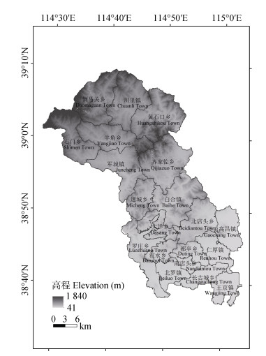
图1唐县地理位置及高程图
Figure1.Position and elevation map of Tang County
 下载: 全尺寸图片幻灯片
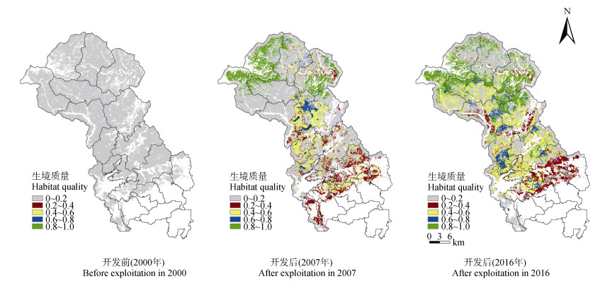
图2唐县未利用地开发前后生境质量空间分布图
Figure2.Spatial distribution of habitat quality before and after unused land exploitation in Tang County
下载: 全尺寸图片幻灯片表1景观指数及其生态学含义
Table1.Landscape indexes and their ecological meaning
| 景观指数Landscape index | 生态学含义Ecological meaning |
| 斑块数量 Number of patches | 景观中斑块总数, 值越大表明景观异质性越高, 同时景观破碎度也越高。 The total number of patches in the landscape; the larger the value, the higher the heterogeneity of landscape and the higher the degree of landscape fragmentation. |
| 斑块密度 Patch density | 单位面积上某种类型斑块的个数, 反映斑块的密集程度。 The number of patches of some type per unit area, it reflects the density of plaques. |
| 平均斑块面积 Mean patch area | 景观总面积与斑块数量的比值, 值越大景观破碎度越低。 The ratio of the total landscape area to the number of patches; the larger the value, the lower the degree of landscape fragmentation. |
| 最大斑块指数 Largest patch index | 某一斑块类型中的最大斑块占据整个景观面积的比例, 其值的大小决定着景观中的优势种、内部种的丰度等生态特征, 反映人类活动的方向和强弱。 The proportion of the largest patch of a certain patch type of the whole landscape area, and its value determines the dominant species in the landscape, the abundance of internal species and other ecological characteristics, and reflects the direction and strength of human activities. |
| 斑块所占景观面积比 Area percent of patch to landscape | 某一斑块类型的总面积占整个景观面积的百分比, 反映景观中模地或优势景观元素。 The percentage of the total area of a certain patch type in the whole landscape area, it reflects the mold land or dominant landscape elements in the landscape. |
| 均匀度指数 Shannon’s evenness index | 反映景观组成的均匀度和优势度, 其值越大, 表明斑块类型越多或各景观组分所占比例越接近。 Reflecting the uniformity and dominance of landscape composition, the greater the value, the more types of patches or the closer the proportion of each landscape component. |
| 多样性指数 Shannon’s diversity index | 表示土地利用斑块类型的丰富程度, 反映土地生态系统结构的合理程度。 It represents the richness of land use patch type and reflects the reasonable degree of land ecosystem structure. |
下载: 导出CSV表2威胁源的最大影响距离、权重和空间衰退类型
Table2.Maximum distance of influence, weight and type of decay over space of threat factors
| 威胁因子 Threat factor | 最大影响距离 Max distance of influence (km) | 权重 Weight | 空间衰退类型 Type of decay over space |
| 城镇和农村居民点用地Urban and rural settlements | 1.0 | 1.0 | 线性Linear |
| 交通用地Transportation land | 0.5 | 0.6 | 线性Linear |
下载: 导出CSV表3不同土地利用类型生境适宜度及其对各威胁源的敏感度
Table3.Habitat suitability and sensitivity to various threat sources of different land use types
| 土地利用类型 Land use type | 生境质量得分 Habitat quality score | 威胁因子Threat factor | |
| 城镇和农村居民点用地 Urban and rural settlements | 交通用地 Transportation land | ||
| 耕地Cultivated land | 0.4 | 0.3 | 0 |
| 林地Forest land | 1.0 | 0.9 | 0 |
| 草地Grassland | 0.6 | 0.3 | 0.2 |
| 城镇和农村居民点用地Urban and rural settlements | 0 | 0 | 0.8 |
| 交通用地Transportation land | 0 | 0 | 0.8 |
| 水域Water area | 0.9 | 0.9 | 0.2 |
| 未利用地Unused land | 0.1 | 0.1 | 0.6 |
下载: 导出CSV表4唐县未利用地开发前(2000年)、开发后(2007年和2016年)土地利用转移矩阵
Table4.Transfer matrix of land use before (2000) and after (2007 and 2016) exploitation of unused land in Tang County?
| 年份 Year | 类型 Type | 耕地 Cultivated land | 林地 Forest land | 草地 Grassland | 城镇和农村居民点用地 Urban and rural settlements | 交通用地 Transportation land | 水域 Water area | 未利用地 Unused land |
| 2000—2007 | 未利用地Unused land | 11.34 | 14.01 | 17.72 | 3.83 | 0.69 | 0.45 | 51.96 |
| 2007—2016 | 耕地Cultivated land | 40.08 | 7.09 | 24.49 | 7.32 | 1.77 | 0.95 | 18.30 |
| 林地Forest land | 0.83 | 73.18 | 8.96 | 0.19 | 0.05 | 0.03 | 16.76 | |
| 草地Grassland | 10.32 | 16.51 | 43.81 | 3.50 | 0.81 | 0.20 | 24.85 | |
| 城镇和农村居民点 Urban and rural settlements | 7.04 | 1.66 | 20.20 | 52.93 | 5.83 | 1.31 | 11.03 | |
| 交通用地Transportation land | 2.90 | 0.11 | 15.40 | 27.83 | 8.74 | 10.41 | 34.61 | |
| 水域Water area | 3.70 | 0.92 | 18.34 | 6.33 | 6.58 | 59.87 | 4.26 | |
| 未利用地Unused land | 7.08 | 13.96 | 28.22 | 3.41 | 0.62 | 0.17 | 46.54 | |
| 2000—2016 | 未利用地Unused land | 10.46 | 21.30 | 27.43 | 5.49 | 0.99 | 0.63 | 33.70 |
下载: 导出CSV表5唐县未利用地开发前(2000年)、开发后(2007年和2016年)类型水平景观指数变化
Table5.Landscape indexes changes at type level before (2000) and after (2007 and 2016) exploitation of unused land in Tang County
| 地类 Type | 最大斑块指数 Largest patch index (%) | 斑块所占景观面积比 Area percent of patch to landscape (%) | 平均斑块面积 Mean patch area (hm2) | ||||||||||||
| 2000 | 2007 | 2016 | 2000 | 2007 | 2016 | 2000 | 2007 | 2016 | |||||||
| 耕地Cultivated land | 0.66 | 1.76 | 11.34 | 10.46 | 3.51 | 3.76 | |||||||||
| 林地Forest land | 4.25 | 4.97 | 14.00 | 21.27 | 6.31 | 3.48 | |||||||||
| 草地Grassland | 4.65 | 3.84 | 17.72 | 27.45 | 3.82 | 3.89 | |||||||||
| 城镇和农村居民点 Urban and rural settlements | 0.59 | 0.29 | 3.83 | 5.50 | 1.77 | 1.72 | |||||||||
| 交通用地Transportation land | 0.11 | 0.03 | 0.69 | 0.99 | 1.65 | 0.63 | |||||||||
| 水域Water area | 0.12 | 0.14 | 0.47 | 0.64 | 1.03 | 1.29 | |||||||||
| 未利用地Unused land | 95.94 | 20.24 | 4.51 | 100.00 | 51.95 | 33.69 | 94.73 | 11.87 | 6.15 | ||||||
下载: 导出CSV表6唐县未利用地开发前(2000年)、开发后(2007年和2016年)景观水平景观指数变化
Table6.Landscape indexes changes at landscape level before (2000) and after (2007 and 2016) exploitation of unused land in Tang County
| 年份 Year | 斑块数量 Patches number | 斑块密度 Patch density | 均匀度指数 Shannon’s evenness index | 多样性指数 Shannon’s diversity index |
| 2000 | 961 | 1.06 | 0 | 0 |
| 2007 | 15 881 | 17.50 | 0.70 | 1.35 |
| 2016 | 24 232 | 26.69 | 0.78 | 1.52 |
下载: 导出CSV表7唐县未利用地开发前(2000年)、开发后(2007年和2016年)各等级生境比例及生境平均值
Table7.Percentage of each habitat level and average value of habitat quality before (2000) and after (2007 and 2016) unused land exploitation in Tang County
| 生境质量得分 Habitat quality score | 比例Proportion (%) | ||
| 2000 | 2007 | 2016 | |
| 0~0.2 | 100.00 | 66.16 | 49.07 |
| > 0.2~0.4 | 9.62 | 8.86 | |
| > 0.4~0.6 | 12.79 | 24.04 | |
| > 0.6~0.8 | 0.38 | 0.42 | |
| > 0.8~1.0 | 11.05 | 17.61 | |
| 生境质量平均值 Average value of habitat quality | 0.09 | 0.28 | 0.39 |
下载: 导出CSV参考文献
| [1] | 彭建, 徐飞雄, 吴见, 等.典型旅游城市生境质量空间分异及其影响机理研究——以黄山市为例[J].长江流域资源与环境, 2019, 28(10):2397-2409 http://www.wanfangdata.com.cn/details/detail.do?_type=perio&id=cjlyzyyhj201910012 PENG J, XU F X, WU J, et al. Spatial differentiation of habitat quality in typical tourist city and their influencing factors mechanisms:A case study of Huangshan City[J]. Resources and Environment in the Yangtze Basin, 2019, 28(10):2397-2409 http://www.wanfangdata.com.cn/details/detail.do?_type=perio&id=cjlyzyyhj201910012 |
| [2] | 王玉, 傅碧天, 吕永鹏, 等.基于SolVES模型的生态系统服务社会价值评估——以吴淞炮台湾湿地森林公园为例[J].应用生态学报, 2016, 27(6):1767-1774 http://www.wanfangdata.com.cn/details/detail.do?_type=perio&id=yystxb201606008 WANG Y, FU B T, LYU Y P, et al. Assessment of the social values of ecosystem services based on SoLVES model:A case study of Wusong Paotaiwan Wetland Forest Park, Shanghai, China[J]. Chinese Journal of Applied Ecology, 2016, 27(6):1767-1774 http://www.wanfangdata.com.cn/details/detail.do?_type=perio&id=yystxb201606008 |
| [3] | 孟庆林, 李明玉, 任春颖, 等.基于HSI模型的吉林省东部地区生境质量动态评价[J].国土资源遥感, 2019, 31(3):140-147 http://d.old.wanfangdata.com.cn/Periodical/gtzyyg201903018 MENG Q L, LI M Y, REN C Y, et al. Dynamic assessment of habitat quality in eastern Jilin Province based on HSI model[J]. Remote Sensing for Land & Resources, 2019, 31(3):140-147 http://d.old.wanfangdata.com.cn/Periodical/gtzyyg201903018 |
| [4] | 刘园, 周勇, 杜越天.基于InVEST模型的长江中游经济带生境质量的时空分异特征及其地形梯度效应[J].长江流域资源与环境, 2019, 28(10):2429-2440 http://d.old.wanfangdata.com.cn/Periodical/cjlyzyyhj201910015 LIU Y, ZHOU Y, DU Y T. Study on the spatio-temporal patterns of habitat quality and its terrain gradient effects of the middle of the Yangtze River Economic Belt based on InVEST model[J]. Resources and Environment in the Yangtze Basin, 2019, 28(10):2429-2440 http://d.old.wanfangdata.com.cn/Periodical/cjlyzyyhj201910015 |
| [5] | 金龙如, 孙克萍, 贺红士, 等.生境适宜度指数模型研究进展[J].生态学杂志, 2008, 27(5):841-846 http://d.old.wanfangdata.com.cn/Periodical/stxzz200805028 JIN L R, SUN K P, HE H S, et al. Research advances in habitat suitability index model[J]. Chinese Journal of Ecology, 2008, 27(5):841-846 http://d.old.wanfangdata.com.cn/Periodical/stxzz200805028 |
| [6] | 黄从红, 杨军, 张文娟.生态系统服务功能评估模型研究进展[J].生态学杂志, 2013, 32(12):3360-3367 http://d.old.wanfangdata.com.cn/Periodical/stxzz201312035 HUANG C H, YANG J, ZHANG W J. Development of ecosystem services evaluation models:Research progress[J]. Chinese Journal of Ecology, 2013, 32(12):3360-3367 http://d.old.wanfangdata.com.cn/Periodical/stxzz201312035 |
| [7] | TAYLOR P D, FAHRIG L, HENEIN K, et al. Connectivity is a vital element of landscape structure[J]. Oikos, 1993, 68(3):571-573 doi: 10.2307-3544927/ |
| [8] | YORK A M, SHRESTHA M, BOONE C G, et al. Land fragmentation under rapid urbanization:A cross-site analysis of Southwestern cities[J]. Urban Ecosystems, 2011, 14(3):429-455 |
| [9] | FITZSIMONS J, PEARSON C J, LAWSON C, et al. Evaluation of land-use planning in greenbelts based on intrinsic characteristics and stakeholder values[J]. Landscape and Urban Planning, 2012, 106(1):23-34 http://www.wanfangdata.com.cn/details/detail.do?_type=perio&id=e9697b5a79272075e5c69c50a6ebe08c |
| [10] | AFSHARI M, MAFI E. Land capability assessment for regional planning using AHP and GIS at Shandiz Urban Region, Northeast Iran[J]. Environment and Urbanization ASIA, 2014, 5(1):105-118 http://www.wanfangdata.com.cn/details/detail.do?_type=perio&id=3225b5d6676ad3fbb4223b8d16d86266 |
| [11] | 韦仕川, 吴次芳, 杨杨.黄河三角洲未利用地适宜性评价的资源开发模式——以山东省东营市为例[J].中国土地科学, 2013, 27(1):55-60 http://www.wanfangdata.com.cn/details/detail.do?_type=perio&id=CASS_44777659 WEI S C, WU C F, YANG Y. The land development models in Yellow River Delta:Based on land suitability evaluation for unutilized land resources[J]. China Land Science, 2013, 27(1):55-60 http://www.wanfangdata.com.cn/details/detail.do?_type=perio&id=CASS_44777659 |
| [12] | 曾庆敏, 刘新平.天山北坡经济带宜耕未利用地开发潜力分区及评价——以新疆阜康市为例[J].中国生态农业学报, 2016, 24(6):819-828 http://www.wanfangdata.com.cn/details/detail.do?_type=perio&id=stnyyj201606014 ZENG Q M, LIU X P. Evaluation of potential of unused land exploitation in northern Tianshan Mountain Economic Belt-A case study of Fukang City[J]. Chinese Journal of Eco-Agriculture, 2016, 24(6):819-828 http://www.wanfangdata.com.cn/details/detail.do?_type=perio&id=stnyyj201606014 |
| [13] | 朱成立, 侯淑楠, 忻海飞.江苏省宜农未利用地开垦土壤改良模式研究[J].灌溉排水学报, 2010, 29(2):50-53 http://d.old.wanfangdata.com.cn/Periodical/ggps201002012 ZHU C L, HOU S N, XIN H F. Soil improvement models of potential land resources suitable for agriculture in Jiangsu Province[J]. Journal of Irrigation and Drainage, 2010, 29(2):50-53 http://d.old.wanfangdata.com.cn/Periodical/ggps201002012 |
| [14] | 彭建, 谢盼, 刘焱序, 等.低丘缓坡建设开发综合生态风险评价及发展权衡——以大理白族自治州为例[J].地理学报, 2015, 70(11):1747-1761 http://www.wanfangdata.com.cn/details/detail.do?_type=perio&id=dlxb201511005 PENG J, XIE P, LIU Y X, et al. Integrated ecological risk assessment and spatial development trade-offs in low-slope hilly land:A case study in Dali Bai Autonomous Prefecture, China[J]. Acta Geographica Sinica, 2015, 70(11):1747-1761 http://www.wanfangdata.com.cn/details/detail.do?_type=perio&id=dlxb201511005 |
| [15] | 潘翔, 石培基, 吴娜.黄土丘陵沟壑区生态风险空间识别及开发利用权衡——以兰州市为例[J].环境科学学报, 2018, 38(1):380-389 http://www.wanfangdata.com.cn/details/detail.do?_type=perio&id=hjkxxb201801043 PAN X, SHI P J, WU N. Spatial identification of ecological risk and development balance in loess hilly and gully region:A case study of Lanzhou[J]. Acta Scientiae Circumstantiae, 2018, 38(1):380-389 http://www.wanfangdata.com.cn/details/detail.do?_type=perio&id=hjkxxb201801043 |
| [16] | 冯舒, 孙然好, 陈利顶.基于土地利用格局变化的北京市生境质量时空演变研究[J].生态学报, 2018, 38(12):4167-4179 http://d.old.wanfangdata.com.cn/Periodical/stxb201812007 FENG S, SUN R H, CHEN L D. Spatio-temporal variability of habitat quality based on land use pattern change in Beijing[J]. Acta Ecologica Sinica, 2018, 38(12):4167-4179 http://d.old.wanfangdata.com.cn/Periodical/stxb201812007 |
| [17] | 刘春芳, 王川.基于土地利用变化的黄土丘陵区生境质量时空演变特征——以榆中县为例[J].生态学报, 2018, 38(20):7300-7311 http://www.wanfangdata.com.cn/details/detail.do?_type=perio&id=stxb201820016 LIU C F, WANG C. Spatio-temporal evolution characteristics of habitat quality in the loess hilly region based on land use change:A case study in Yuzhong County[J]. Acta Ecologica Sinica, 2018, 38(20):7300-7311 http://www.wanfangdata.com.cn/details/detail.do?_type=perio&id=stxb201820016 |
| [18] | 郑新奇, 付梅臣.景观格局空间分析技术及其应用[M].北京:科学出版社, 2010 ZHENG X Q, FU M C. Spatial Analysis of Landscape Pattern and Application[M]. Beijing:Science Press, 2010 |
| [19] | 陈文波, 肖笃宁, 李秀珍.景观指数分类、应用及构建研究[J].应用生态学报, 2002, 13(1):121-125 http://d.old.wanfangdata.com.cn/Periodical/yystxb200201027 CHEN W B, XIAO D N, LI X Z. Classification, application, and creation of landscape indices[J]. Chinese Journal of Applied Ecology, 2002, 13(1):121-125 http://d.old.wanfangdata.com.cn/Periodical/yystxb200201027 |
| [20] | 何鹏, 张会儒.常用景观指数的因子分析和筛选方法研究[J].林业科学研究, 2009, 22(4):470-474 http://d.old.wanfangdata.com.cn/Periodical/lykxyj200904002 HE P, ZHANG H R. Study on factor analysis and selection of common landscape metrics[J]. Forest Research, 2009, 22(4):470-474 http://d.old.wanfangdata.com.cn/Periodical/lykxyj200904002 |
| [21] | 彭建, 王仰麟, 张源, 等.土地利用分类对景观格局指数的影响[J].地理学报, 2006, 61(2):157-168 http://d.old.wanfangdata.com.cn/Periodical/dlxb200602005 PENG J, WANG Y L, ZHANG Y, et al. Research on the influence of land use classification on landscape metrics[J]. Acta Geographica Sinica, 2006, 61(2):157-168 http://d.old.wanfangdata.com.cn/Periodical/dlxb200602005 |
| [22] | 李屹峰, 罗跃初, 刘纲, 等.土地利用变化对生态系统服务功能的影响——以密云水库流域为例[J].生态学报, 2013, 33(3):726-736 http://www.wanfangdata.com.cn/details/detail.do?_type=perio&id=stxb201303007 LI Y F, LUO Y C, LIU G, et al. Effects of land use change on ecosystem services:A case study in Miyun Reservoir Watershed[J]. Acta Ecologica Sinica, 2013, 33(3):726-736 http://www.wanfangdata.com.cn/details/detail.do?_type=perio&id=stxb201303007 |
| [23] | 潘韬, 吴绍洪, 戴尔阜, 等.基于InVEST模型的三江源区生态系统水源供给服务时空变化[J].应用生态学报, 2013, 24(1):183-189 http://d.old.wanfangdata.com.cn/Periodical/yystxb201301026 PAN T, WU S H, DAI E F, et al. Spatiotemporal variation of water source supply service in Three Rivers Source Area of China based on InVEST model[J]. Chinese Journal of Applied Ecology, 2013, 24(1):183-189 http://d.old.wanfangdata.com.cn/Periodical/yystxb201301026 |
| [24] | SHARP R, CHAPLIN-KRAMER R, WOOD S, et al. InVEST User' Guide[M/OL]. 2017.[2019−12−09]. http://data.natu-ralcapitalproject.org/nightly-build/invest-users-guide/html/ |
| [25] | 吴健生, 曹祺文, 石淑芹, 等.基于土地利用变化的京津冀生境质量时空演变[J].应用生态学报, 2015, 26(11):3457-3466 http://d.old.wanfangdata.com.cn/Periodical/yystxb201511027 WU J S, CAO Q W, SHI S Q, et al. Spatio-temporal variability of habitat quality in Beijing-Tianjin-Hebei area based on land use change[J]. Chinese Journal of Applied Ecology, 2015, 26(11):3457-3466 http://d.old.wanfangdata.com.cn/Periodical/yystxb201511027 |
| [26] | 杨志鹏, 许嘉巍, 冯兴华, 等.基于InVEST模型的东北地区土地利用变化对生境的影响研究[J].生态科学, 2018, 37(6):139-147 http://d.old.wanfangdata.com.cn/Periodical/stkx201806018 YANG Z P, XU J W, FENG X H, et al. Effects of land use change on habitat based on InVEST model in northeast China[J]. Ecological Science, 2018, 37(6):139-147 http://d.old.wanfangdata.com.cn/Periodical/stkx201806018 |
| [27] | 巩杰, 马学成, 张玲玲, 等.基于InVEST模型的甘肃白龙江流域生境质量时空分异[J].水土保持研究, 2018, 25(3):191-196 http://d.old.wanfangdata.com.cn/Periodical/stbcyj201803031 GONG J, MA X C, ZHANG L L, et al. Spatiotemporal variation of habitat quality in Bailongjiang watershed in Gansu based on InVEST model[J]. Research of Soil and Water Conservation, 2018, 25(3):191-196 http://d.old.wanfangdata.com.cn/Periodical/stbcyj201803031 |
| [28] | NELSON E, MENDOZA G, REGETZ J, et al. Modeling multiple ecosystem services, biodiversity conservation, commodity production, and tradeoffs at landscape scales[J]. Frontiers in Ecology and the Environment, 2009, 7(1):4-11 http://d.old.wanfangdata.com.cn/NSTLQK/NSTL_QKJJ0216582972/ |
| [29] | 白杨, 郑华, 庄长伟, 等.白洋淀流域生态系统服务评估及其调控[J].生态学报, 2013, 33(3):711-717 http://d.old.wanfangdata.com.cn/Periodical/stxb201303005 BAI Y, ZHENG H, ZHUANG C W, et al. Ecosystem services valuation and its regulation in Baiyangdian Baisn:Based on InVEST model[J]. Acta Ecologica Sinica, 2013, 33(3):711-717 http://d.old.wanfangdata.com.cn/Periodical/stxb201303005 |
| [30] | 王燕, 高吉喜, 金宇, 等.基于2005-2015年土地利用变化和InVEST模型的内蒙古巴林右旗农牧交错带生境质量研究[J].生态与农村环境学报, 2020, 36(1):1-10 http://d.old.wanfangdata.com.cn/Periodical/ncsthj202005016 WANG Y, GAO J X, JIN Y, et al. Habitat quality of farming-pastoral ecotone in Bairin Right Banner, Inner Mongolia based on land use change and InVEST model from 2005-2015[J]. Journal of Ecology and Rural Environment, 2020, 36(1):1-10 http://d.old.wanfangdata.com.cn/Periodical/ncsthj202005016 |
| [31] | 谢怡凡, 姚顺波, 邓元杰, 等.延安市退耕还林(草)工程对生境质量时空格局的影响[J].中国生态农业学报(中英文), 2020, 28(4):575-586 http://www.ecoagri.ac.cn/zgstny/ch/reader/view_abstract.aspx?file_no=2020-0411&flag=1 XIE Y F, YAO S B, DENG Y J, et al. Impact of the 'Grain for Green' project on the spatial and temporal pattern of habitat quality in Yan'an City, China[J]. Chinese Journal of Eco-Agriculture, 2020, 28(4):575-586 http://www.ecoagri.ac.cn/zgstny/ch/reader/view_abstract.aspx?file_no=2020-0411&flag=1 |
