姚顺波,,
邓元杰,
贾磊,
李园园,
高晴
西北农林科技大学经济管理学院/资源经济与环境管理研究中心 杨凌 712100
基金项目: 林业公益性行业科研专项经费201504424
详细信息
作者简介:谢怡凡, 主要研究方向为土地资源管理、资源经济与环境管理。E-mail:15527504128@163.com
通讯作者:姚顺波, 主要研究方向为林业政策评估、资源经济与环境管理。E-mail:yaoshunbo@163.com
中图分类号:F301.2;X826计量
文章访问数:376
HTML全文浏览量:2
PDF下载量:1019
被引次数:0
出版历程
收稿日期:2019-10-28
录用日期:2020-01-16
刊出日期:2020-04-01
Impact of the 'Grain for Green' project on the spatial and temporal pattern of habitat quality in Yan'an City, China
XIE Yifan,YAO Shunbo,,
DENG Yuanjie,
JIA Lei,
LI Yuanyuan,
GAO Qing
College of Economic Management, Northwest A & F University/Center for Resource Economy and Environmental Management, Yangling 712100, China
Funds: This study was supported by the Special Funds for Scientific Research in Forestry Public Welfare Industry of China201504424
More Information
Corresponding author:YAO Shunbo, E-mail:yaoshunbo@163.com
摘要
HTML全文
图
参考文献
相关文章
施引文献
资源附件
访问统计
摘要
摘要:评估退耕还林(草)工程后生境质量的时空演化特征,对指导下一轮生态修复工程的实施以及协调区域生态系统和社会经济可持续发展具有重要意义。该研究以退耕还林(草)先行试点的陕西省延安市为研究对象,以土地利用/覆被数据为基础,运用InVEST模型评估延安市2000年、2008年和2015年生境质量;结合空间探索性分析方法,探讨生境质量的时空演变格局及其驱动因素。结果如下:1)2000—2015年延安市土地利用变化在退耕还林(草)工程驱动下以耕地向林地和草地的转移为主要特征,林地和草地面积在研究期内增加显著。2)延安市2015年生境质量整体较好,空间上呈现南高北低的格局,且研究期内呈上升趋势,区域平均生境指数由2000年的0.69增加到2015年的0.71。3)区域生境质量表现出显著的正向全局空间自相关,且空间聚类分异特征明显;南部的黄陵县和黄龙县等森林资源丰富地区主要呈现出高高集聚特征,而低低集聚区和高低集聚区交叉分布集中在北部宝塔区、子长县、安塞县、吴起县等城镇及其周边农业生产区。4)退耕还林(草)工程对区域生境质量提升有显著推动作用,因此可以通过优化土地利用格局和结构,尤其是林地草地,构建生态保护和经济发展协调平衡的政策体系,针对区域生态问题系统地提高区域生境质量和生态系统稳定性。
关键词:退耕还林(草)/
生境质量/
土地利用变化/
InVEST模型/
延安市
Abstract:In an attempt to alleviate increasing pressure caused by human activities on the environment, numerous ecological restoration projects have been implemented around the world. The 'Grain for Green' project in China is currently the largest and most extensive ecological restoration project globally. Research indicates the substantial investment given to this project has achieved significant ecological benefits. Habitat quality is an important indicator of the ability of an ecosystem to provide sustainable conditions for persistence of individuals and populations. Accordingly, this study aimed to investigate the temporal and spatial patterns of habitat quality in Yan'an City, the piloted research area of the 'Grain for Green' project, to identify the impact of the restoration project on the city. Research into the impacts of this project are of great significance for successful implementation of ecological restoration projects moving forward, as well as expanding knowledge on regional ecosystems, and on socio-economic sustainable development. Land use/land cover data of Yan'an City in 2000, 2008, and 2015 were evaluated for the study. The habitat quality index of Yan'an City in 2000, 2008, and 2015 was estimated based on the ArcGIS platform and the InVEST model. The temporal and spatial evolution pattern of habitat quality and its driving factor and spatial clustering characteristics were discussed by using the exploratory spatial data analysis. Our results showed that the main feature of land use change in Yan'an City from 2000 to 2015, driven by the 'Grain for Green' project was the conversion of cultivated land to woodland and grassland; the area of woodland and grassland increased significantly in the city during the study period. The habitat quality of Yan'an City in 2015 was relatively good, demonstrating a pattern of high habitat quality in the south, low habitat quality in the north. The habitat quality index showed an upward trend during the study period; the regional average habitat quality index increased from 0.69 in 2000 to 0.71 in 2015. Additionally, habitat quality of the study area as a whole showed significant positive global spatial autocorrelation, and habitat quality, as well as its spatial variation, indicated obvious spatial clustering differentiation characteristics. Forest-rich areas, such as Huangling County and Huanglong County in the south, exhibited predominately high-high agglomeration characteristics highlighting the need for these areas to remain the focus of ecological protection measures. Conversely, low-low and high-low agglomeration areas were found interspersed, and concentrated in the north (i.e., Baota County, Zichang County, Ansai County, Wuqi County, and in other counties as well as agricultural areas of this region); accordingly, ecological restoration in northern areas should be strengthened and consolidated. Our results indicate that the 'Grain for Green' project will likely affect the processes and functions of the Yan'an City ecosystem by changing land use patterns and structure. In particular, the increase of forestland and grassland in this area will significantly promote the improvement of regional habitat quality. Therefore, by optimizing land use pattern and structure (in particular forest and grassland habitats) will assist in the development of a more coordinated and balanced policy for ecological protection and economic development in response to regional ecological problems, while systematically improving regional habitat quality and ecosystem stability.
Key words:The 'Grain for Green' project/
Habitat quality/
Land use change/
InVEST model/
Yan'an City
HTML全文

图1延安市高程图
Figure1.Topography of the study area of Yan'an City
 下载: 全尺寸图片幻灯片
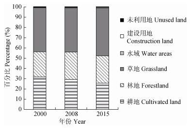
图22000年、2008年和2015年延安土地利用类型面积百分比
Figure2.Percentages of land use types in Yan'an in 2000, 2008 and 2015
下载: 全尺寸图片幻灯片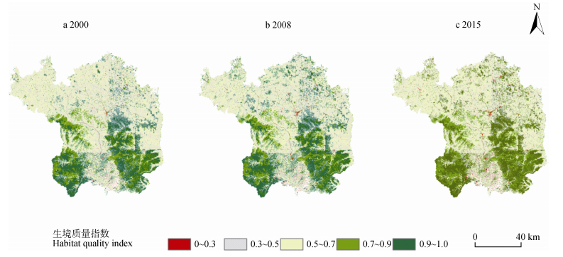
图32000年、2008年和2015年延安市生境质量空间分布
生境质量指数0~0.3、0.3~0.5、0.5~0.7、0.7~0.9和0.9~1.0分别表示生境等级较差生境、一般生境、中度重要生境、高度重要生境和极重要生境。
Figure3.Spatial distribution of habitat quality in Yan'an in 2000, 2008 and 2015
Habitat quality index ranges of 0-0.3, 0.3-0.5, 0.5-0.7, 0.7-0.9 and 0.9-1.0 indicate habitat quality grades of poor habitat, general habitat, moderately important habitat, highly important habitat and most important habitat.
下载: 全尺寸图片幻灯片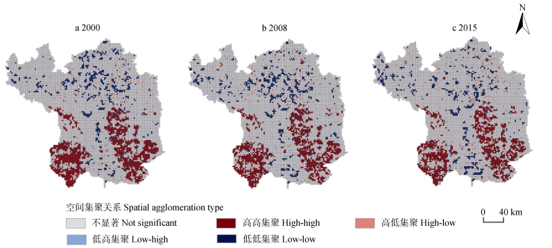
图42000年、2008年和2015年延安市生境质量空间聚类特征(LISA)
Figure4.LISA aggreation of habitat quality in Yan'an in 2000, 2008 and 2015
下载: 全尺寸图片幻灯片
图52000年、2008年和2015年延安市生境质量空间聚类面积变化
Figure5.Change of area of different habitat quality aggreations in Yan'an in 2000, 2008 and 2015
下载: 全尺寸图片幻灯片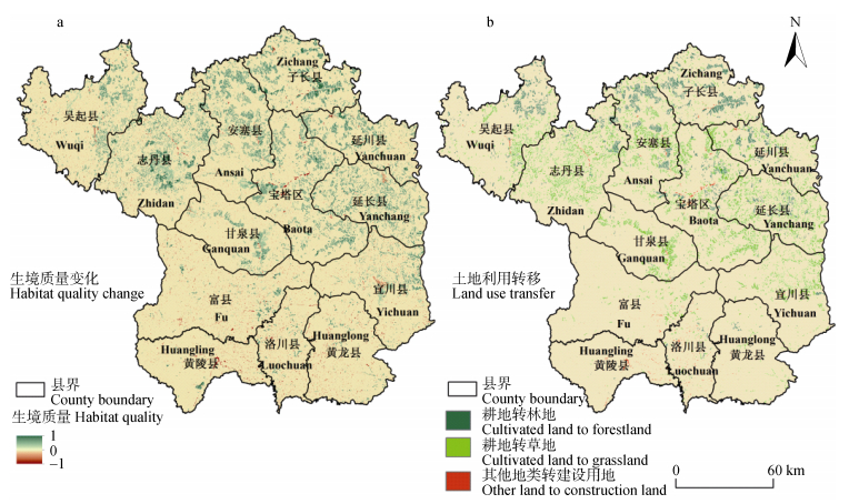
图62000—2015年延安市生境质量(a)和土地利用(b)空间变化
Figure6.Spatial distribution of habitat quality change (a) and land use change (b) in Yan'an from 2000 to 2015
下载: 全尺寸图片幻灯片表1研究区威胁源最大影响距离、权重和衰减类型
Table1.Maximum influence distances, weights and attenuation types of threats of the study area
| 威胁源 Threat source | 最大影响距离 Maximum influence distance (km) | 权重 Weight | 衰减类型 Attenuation type |
| 耕地 Cultivated land | 4 | 0.6 | 线性?Linear |
| 农村居民 Rural residential land | 6 | 0.8 | 指数?Exponential |
| 城镇用地 Urban land | 8 | 1.0 | 指数?Exponential |
| 交通用地 Traffic land | 3 | 0.6 | 线性?Linear |
下载: 导出CSV表2研究区不同地类生境适宜度及其对威胁因子的敏感程度
Table2.Habitat suitability of different land types and their sensitivity to each threat of the study area
| 一级地类 Type | 生境类型 Habitat type | 生境适宜度 Habitat suitability | 敏感程度Sensitivity | |||
| 耕地 Cultivated land | 农村居民点 Rural residential land | 城镇用地 Urban land | 交通用地 Traffic land | |||
| 耕地 Cultivated land | 耕地Cultivated land | 0.5 | 0.3 | 0.35 | 0.5 | 0.3 |
| 林地 Forestland | 有林地Woodland | 1.0 | 0.7 | 0.8 | 0.8 | 0.65 |
| 灌林地Shrub land | 1.0 | 0.6 | 0.65 | 0.7 | 0.6 | |
| 疏林地Sparse woodland | 0.8 | 0.6 | 0.6 | 0.6 | 0.5 | |
| 其他林地Other forestland | 1.0 | 0.8 | 0.85 | 0.85 | 0.7 | |
| 草地 Grassland | 高覆盖度High coverage | 0.8 | 0.5 | 0.55 | 0.6 | 0.35 |
| 中覆盖Moderate coverage | 0.7 | 0.55 | 0.6 | 0.65 | 0.4 | |
| 低覆盖度Low coverage | 0.6 | 0.5 | 0.5 | 0.6 | 0.3 | |
| 水域 Water areas | 水域Water areas | 0.9 | 0.65 | 0.65 | 0.75 | 0.6 |
| 建设用地 Construction land | 城镇用地Urban land | 0 | 0 | 0 | 0 | 0 |
| 农村居民点Rural residential land | 0 | 0 | 0 | 0 | 0 | |
| 交通用地Traffic land | 0 | 0 | 0 | 0 | 0 | |
| 未利用地 Unused land | 未利用地Unused land | 0 | 0 | 0 | 0 | 0 |
下载: 导出CSV表32000—2015年延安土地利用转移矩阵
Table3.Land use change matrix of Yan'an from 2000 to 2015
| 时段 Period | 土地利用类型 Land use type | 耕地 Cultivated land | 林地 Forestland | 草地 Grassland | 水域 Water areas | 建设用地 Construction land | 未利用地 Unused land |
| 2000—2008 | 耕地Cultivated land | 10 726.11 | 603.91 | 422.37 | 0.95 | 16.38 | 0.01 |
| 林地Forestland | 17.19 | 9 012.20 | 22.97 | 0.14 | 0.67 | 0.00 | |
| 草地Grassland | 112.39 | 267.90 | 15 529.90 | 1.47 | 3.77 | 0.01 | |
| 水域Water areas | 3.45 | 0.21 | 0.88 | 151.65 | 0.04 | 0.00 | |
| 建设用地Construction land | 0.48 | 0.09 | 0.33 | 0.03 | 133.56 | 0.00 | |
| 未利用地Unused land | 0.01 | 0.00 | 0.03 | 0.00 | 0.00 | 2.60 | |
| 2008—2015 | 耕地Cultivated land | 9 112.68 | 119.38 | 1 577.73 | 4.23 | 44.18 | 1.45 |
| 林地Forestland | 83.24 | 9 697.43 | 99.71 | 1.30 | 2.49 | 0.13 | |
| 草地Grassland | 291.08 | 78.02 | 15 591.28 | 4.24 | 9.98 | 1.93 | |
| 水域Water areas | 4.55 | 0.74 | 10.41 | 138.29 | 0.19 | 0.05 | |
| 建设用地Construction land | 3.18 | 0.33 | 1.31 | 0.09 | 149.28 | 0.23 | |
| 未利用地Unused land | 0.21 | 0.00 | 1.69 | 0.00 | 0.00 | 0.73 | |
| 2000—2015 | 耕地Cultivated land | 9 182.47 | 676.31 | 1 847.01 | 2.68 | 59.55 | 1.70 |
| 林地Forestland | 67.26 | 8 925.04 | 57.06 | 1.13 | 2.54 | 0.13 | |
| 草地Grassland | 237.29 | 293.56 | 15 365.01 | 4.69 | 12.95 | 1.92 | |
| 水域Water areas | 5.32 | 0.79 | 10.31 | 139.59 | 0.21 | 0.00 | |
| 建设用地Construction land | 2.37 | 0.18 | 0.98 | 0.06 | 130.87 | 0.03 | |
| 未利用地Unused land | 0.20 | 0.00 | 1.70 | 0.00 | 0.00 | 0.74 |
下载: 导出CSV表42000年、2008年和2015年延安生境质量等级面积变化表
Table4.Changes of total area and percentage of each habitat quality grade in Yan'an in 2000, 2008 and 2015
| 生境等级 Habitat quality grade | 指数区间 Index range | 2000 | 2008 | 2015 | |||||
| 面积 Area (km2) | 比例 Percent (%) | 面积 Area (km2) | 比例 Percent (%) | 面积 Area (km2) | 比例 Percent (%) | ||||
| 较差生境Poor habitat | 0~0.3 | 137.20 | 0.37 | 157.19 | 0.42 | 211.07 | 0.57 | ||
| 一般生境General habitat | 0.3~0.5 | 11 773.02 | 31.79 | 10 864.55 | 29.34 | 9 498.80 | 25.65 | ||
| 中度重要生境Moderately important habitat | 0.5~0.7 | 14 007.85 | 37.83 | 13 882.70 | 37.49 | 14 962.20 | 40.40 | ||
| 高度重要生境Highly important habitat | 0.7~0.9 | 3 740.90 | 10.10 | 3 973.30 | 10.73 | 4 201.80 | 11.35 | ||
| 极重要生境Most important habitat | 0.9~1.0 | 7 372.27 | 19.91 | 8 153.68 | 22.02 | 8 157.47 | 22.03 | ||
下载: 导出CSV参考文献
| [1] | 郑华, 欧阳志云, 赵同谦, 等.人类活动对生态系统服务功能的影响[J].自然资源学报, 2003, 18(1):118-126 doi: 10.3321/j.issn:1000-3037.2003.01.018 ZHENG H, OUYANG Z Y, ZHAO T Q, et al. The impact of human activities on ecosystem services[J]. Journal of Natural Resources, 2003, 18(1):118-126 doi: 10.3321/j.issn:1000-3037.2003.01.018 |
| [2] | 欧阳志云, 郑华.生态系统服务的生态学机制研究进展[J].生态学报, 2009, 29(11):6183-6188 doi: 10.3321/j.issn:1000-0933.2009.11.053 OUYANG Z Y, ZHENG H. Ecological mechanisms of ecosystem services[J]. Acta Ecologica Sinica, 2009, 29(11):6183-6188 doi: 10.3321/j.issn:1000-0933.2009.11.053 |
| [3] | TURNER Ⅱ B L, SKOLE D L, SANDERSON S, et al. Land-use and Land-coverChange Science/Research Plan[R]. IGBP Report No. 35, IHDP Report No. 7. Stockholm: IGBP, 1995 |
| [4] | LAWLER J J, LEWIS D J, NELSON E, et al. Projected land-use change impacts on ecosystem services in the United States[J]. Proceedings of the National Academy of Sciences of the United States of America, 2014, 111(20):7492-7497 doi: 10.1073/pnas.1405557111 |
| [5] | 傅伯杰, 陈利顶, 马克明.黄土丘陵区小流域土地利用变化对生态环境的影响——以延安市羊圈沟流域为例[J].地理学报, 1999, 54(3):241-246 doi: 10.3321/j.issn:0375-5444.1999.03.006 FU B J, CHEN L D, MA K M. The effect of land use change on the regional environment in the Yangjuangou catchment in the loess plateau of China[J]. Acta Geographica Sinica, 1999, 54(3):241-246 doi: 10.3321/j.issn:0375-5444.1999.03.006 |
| [6] | 王建华, 田景汉, 吕宪国.挠力河流域河流生境质量评价[J].生态学报, 2010, 30(2):481-486 http://d.old.wanfangdata.com.cn/Periodical/stxb201002025 WANG J H, TIAN J H, LV X G. Assessment of stream habitat quality in Naoli River Watershed, China[J]. Acta Ecologica Sinica, 2010, 30(2):481-486 http://d.old.wanfangdata.com.cn/Periodical/stxb201002025 |
| [7] | 李晓秀.北京山区生态环境质量评价体系初探[J].自然资源, 1997, (5):31-35 http://www.wanfangdata.com.cn/details/detail.do?_type=perio&id=QK199700736960 LI X X. A preliminary study on mountain eco-environment quality evaluation system in Beijing[J]. Natural Resources, 1997, (5):31-35 http://www.wanfangdata.com.cn/details/detail.do?_type=perio&id=QK199700736960 |
| [8] | 吴健生, 曹祺文, 石淑芹, 等.基于土地利用变化的京津冀生境质量时空演变[J].应用生态学报, 2015, 26(11):3457-3466 http://d.old.wanfangdata.com.cn/Periodical/yystxb201511027 WU J S, CAO Q W, SHI S Q, et al. Spatio-temporal variability of habitat quality in Beijing-Tianjin-Hebei Area based on land use change[J]. Chinese Journal of Applied Ecology, 2015, 26(11):3457-3466 http://d.old.wanfangdata.com.cn/Periodical/yystxb201511027 |
| [9] | 吴建国, 吕佳佳.土地利用变化对生物多样性的影响[J].生态环境, 2008, 17(3):1276-1281 doi: 10.3969/j.issn.1674-5906.2008.03.077 WU J G, LV J J. Effects of land use change on the biodiversity[J]. Ecology and Environment, 2008, 17(3):1276-1281 doi: 10.3969/j.issn.1674-5906.2008.03.077 |
| [10] | 欧阳志云, 刘建国, 肖寒, 等.卧龙自然保护区大熊猫生境评价[J].生态学报, 2001, 21(11):1869-1874 doi: 10.3321/j.issn:1000-0933.2001.11.018 OUYANG Z Y, LIU J G, XIAO H, et al. An assessment of giant panda habitat in Wolong Nature Reserve[J]. Acta Ecologica Sinica, 2001, 21(11):1869-1874 doi: 10.3321/j.issn:1000-0933.2001.11.018 |
| [11] | 刘红玉, 李兆富, 白云芳.挠力河流域东方白鹳生境质量变化景观模拟[J].生态学报, 2006, 26(12):4007-4013 doi: 10.3321/j.issn:1000-0933.2006.12.011 LIU H Y, LI Z F, BAI Y F. Landscape simulating of habitat quality change for oriental white stork in Naoli River Watershed[J]. Acta Ecologica Sinica, 2006, 26(12):4007-4013 doi: 10.3321/j.issn:1000-0933.2006.12.011 |
| [12] | BALASOORIYA B L W K, SAMSON R, MBIKWA F, et al. Biomonitoring of urban habitat quality by anatomical and chemical leaf characteristics[J]. Environmental and Experimental Botany, 2008, 65(2/3):386-394 http://www.wanfangdata.com.cn/details/detail.do?_type=perio&id=36dc9d90cfb756789e073b1abc34185a |
| [13] | SHERROUSE B C, SEMMENS D J, CLEMENT J M. An application of social values for ecosystem services (SolVES) to three national forests in Colorado and Wyoming[J]. Ecological Indicators, 2014, 36:68-79 doi: 10.1016/j.ecolind.2013.07.008 |
| [14] | 黄从红, 杨军, 张文娟.生态系统服务功能评估模型研究进展[J].生态学杂志, 2013, 32(12):3360-3367 http://d.old.wanfangdata.com.cn/Periodical/stxzz201312035 HUANG C H, YANG J, ZHANG W J. Development of ecosystem services evaluation models:Research progress[J]. Chinese Journal of Ecology, 2013, 32(12):3360-3367 http://d.old.wanfangdata.com.cn/Periodical/stxzz201312035 |
| [15] | SALLUSTIO L, DE TONI A, STROLLO A, et al. Assessing habitat quality in relation to the spatial distribution of protected areas in Italy[J]. Journal of Environmental Management, 2017, 201:129-137 doi: 10.1016/j.jenvman.2017.06.031 |
| [16] | BOUMANS R, COSTANZA R, FARLEY J, et al. Modeling the dynamics of the integrated earth system and the value of global ecosystem services using the GUMBO model[J]. Ecological Economics, 2002, 41(3):529-560 doi: 10.1016/S0921-8009(02)00098-8 |
| [17] | 包玉斌, 刘康, 李婷, 等.基于InVEST模型的土地利用变化对生境的影响——以陕西省黄河湿地自然保护区为例[J].干旱区研究, 2015, 32(3):622-629 http://d.old.wanfangdata.com.cn/Conference/8965046 BAO Y B, LIU K, LI T, et al. Effects of land use change on habitat based on InVEST model-taking Yellow River Wetland Nature Reserve in Shaanxi Province as an example[J]. Arid Zone Research, 2015, 32(3):622-629 http://d.old.wanfangdata.com.cn/Conference/8965046 |
| [18] | 钟莉娜, 王军.基于InVEST模型评估土地整治对生境质量的影响[J].农业工程学报, 2017, 33(1):250-255 http://d.old.wanfangdata.com.cn/Periodical/nygcxb201701034 ZHONG L N, WANG J. Evaluation on effect of land consolidation on habitat quality based on InVEST model[J]. Transactions of the Chinese Society of Agricultural Engineering, 2017, 33(1):250-255 http://d.old.wanfangdata.com.cn/Periodical/nygcxb201701034 |
| [19] | 任涵, 张静静, 朱文博, 等.太行山淇河流域土地利用变化对生境的影响[J].地理科学进展, 2018, 37(12):1693-1704 http://d.old.wanfangdata.com.cn/Periodical/dlkxjz201812011 REN H, ZHANG J J, ZHU W B, et al. Impact of land use change on habitat in the Qihe River Basin of Taihang Mountains[J]. Progress in Geography, 2018, 37(12):1693-1704 http://d.old.wanfangdata.com.cn/Periodical/dlkxjz201812011 |
| [20] | 王惠, 许月卿, 刘超, 等.基于地理加权回归的生境质量对土地利用变化的响应——以河北省张家口市为例[J].北京大学学报:自然科学版, 2019, 55(3):509-518 http://www.wanfangdata.com.cn/details/detail.do?_type=perio&id=bjdxxb201903013 WANG H, XU Y Q, LIU C, et al. Response of habitat quality to land use change based on geographical weighted regression[J]. Acta Scientiarum Naturalium Universitatis Pekinensis, 2019, 55(3):509-518 http://www.wanfangdata.com.cn/details/detail.do?_type=perio&id=bjdxxb201903013 |
| [21] | 孙艺杰, 任志远, 郝梦雅, 等.黄土高原生态系统服务权衡与协同时空变化及影响因素——以延安市为例[J].生态学报, 2019, 39(10):3443-3454 http://www.wanfangdata.com.cn/details/detail.do?_type=perio&id=stxb201910004 SUN Y J, REN Z Y, HAO M Y, et al. Spatial and temporal changes in the synergy and trade-off between ecosystem services, and its influencing factors in Yan'an, Loess Plateau[J]. Acta Ecologica Sinica, 2019, 39(10):3443-3454 http://www.wanfangdata.com.cn/details/detail.do?_type=perio&id=stxb201910004 |
| [22] | 侯孟阳, 姚顺波, 邓元杰, 等.格网尺度下延安市生态服务价值时空演变格局与分异特征——基于退耕还林工程的实施背景[J].自然资源学报, 2019, 34(3):539-552 http://www.wanfangdata.com.cn/details/detail.do?_type=perio&id=zrzyxb201903008 HOU M Y, YAO S B, DENG Y J, et al. Spatial-temporal evolution pattern and differentiation of ecological service value in Yan'an City at the grid scale based on Sloping Land Conversion Program[J]. Journal of Natural Resources, 2019, 34(3):539-552 http://www.wanfangdata.com.cn/details/detail.do?_type=perio&id=zrzyxb201903008 |
| [23] | 马晓熠, 裴韬.基于探索性空间数据分析方法的北京市区域经济差异[J].地理科学进展, 2010, 29(12):1555-1561 doi: 10.11820/dlkxjz.2010.12.012 MA X Y, PEI T. Exploratory spatial data analysis of regional economic disparities in Beijing during 2001-2007[J]. Progress in Geography, 2010, 29(12):1555-1561 doi: 10.11820/dlkxjz.2010.12.012 |
| [24] | 马晓冬, 马荣华, 徐建刚.基于ESDA-GIS的城镇群体空间结构[J].地理学报, 2004, 59(6):1048-1057 doi: 10.3321/j.issn:0375-5444.2004.06.029 MA X D, MA R H, XU J G. Spatial structure of cities and towns with ESDA-GIS framework[J]. Acta Geographica Sinica, 2004, 59(6):1048-1057 doi: 10.3321/j.issn:0375-5444.2004.06.029 |
| [25] | ANSELIN L. Local indicators of spatial association-LISA[J]. Geographical Analysis, 1995, 27(2):93-115 doi: 10.1111-j.1538-4632.1995.tb00338.x/ |
| [26] | 张琨, 吕一河, 傅伯杰.黄土高原典型区植被恢复及其对生态系统服务的影响[J].生态与农村环境学报, 2017, 33(1):23-31 http://d.old.wanfangdata.com.cn/Periodical/ncsthj201701004 ZHANG K, L Y H, FU B J. Vegetation restoration and its influences on ecosystem services in areas typical of the loess plateau[J]. Journal of Ecology and Rural Environment, 2017, 33(1):23-31 http://d.old.wanfangdata.com.cn/Periodical/ncsthj201701004 |
| [27] | 王森, 王海燕, 谢永生, 等.延安市退耕还林前后土壤保持生态服务功能评价[J].水土保持研究, 2019, 26(1):280-286 http://d.old.wanfangdata.com.cn/Periodical/stbcyj201901045 WANG S, WANG H Y, XIE Y S, et al. Evaluation of ecological service function of soil conservation before and after grain for green project in Yan'an City[J]. Research of Soil and Water Conservation, 2019, 26(1):280-286 http://d.old.wanfangdata.com.cn/Periodical/stbcyj201901045 |
| [28] | DAILY G C, OUYANG Z Y, ZHENG H, et al. Securing natural capital and human Well-Being:Innovation and impact in China[J]. Acta Ecologica Sinica, 2013, 33(3):669-685 doi: 10.5846/stxb201212311905 |
| [29] | 肖强, 肖洋, 欧阳志云, 等.重庆市森林生态系统服务功能价值评估[J].生态学报, 2014, 34(1):216-223 http://d.old.wanfangdata.com.cn/Periodical/stxb201401027 XIAO Q, XIAO Y, OUYANG Z Y, et al. Value assessment of the function of the forest ecosystem services in Chongqing[J]. Acta Ecologica Sinica, 2014, 34(1):216-223 http://d.old.wanfangdata.com.cn/Periodical/stxb201401027 |
| [30] | 马克明, 傅伯杰, 黎晓亚, 等.区域生态安全格局:概念与理论基础[J].生态学报, 2004, 24(4):761-768 doi: 10.3321/j.issn:1000-0933.2004.04.017 MA K M, FU B J, LI X Y, et al. The regional pattern for ecological security (RPES):The concept and theoretical basis[J]. Acta Ecologica Sinica, 2004, 24(4):761-768 doi: 10.3321/j.issn:1000-0933.2004.04.017 |
