裴久渤,,
汪景宽
沈阳农业大学土地与环境学院/土肥资源高效利用国家工程实验室/农业部东北耕地保育重点实验室 沈阳 110866
基金项目: 国家重点研发计划课题2017YFD0200604
国家自然科学基金项目41807086
国家自然科学基金项目41671293
辽宁省自然科学基金项目20170540799
沈阳农业大学博士启动基金880416042
沈阳农业大学博士启动基金880416020
详细信息
作者简介:姚东恒, 主要从事耕地资源管理方面研究。E-mail:1377648109@qq.com
通讯作者:裴久渤, 主要从事土壤肥力与耕地质量方面研究。E-mail:peijiubo@syau.edu.cn
中图分类号:S158.9计量
文章访问数:682
HTML全文浏览量:3
PDF下载量:502
被引次数:0
出版历程
收稿日期:2019-07-02
录用日期:2019-10-30
刊出日期:2020-01-01
Temporal-spatial changes in cultivated land quality in a black soil region of Northeast China
YAO Dongheng,PEI Jiubo,,
WANG Jingkuan
College of Land and Environment, Shenyang Agricultural University/National Engineering Laboratory for Efficient Utilization of Soil and Fertilizer Resources/Key Laboratory of Northeast Cultivated Land Conservation of Ministry of Agriculture, Shenyang 110866, China
Funds: the National Key R & D Program of China2017YFD0200604
the National Natural Science Foundation of China41807086
the National Natural Science Foundation of China41671293
the Natural Science Foundation of Liaoning Province20170540799
the Doctoral Research Start-Up Funding of Shenyang Agricultural University880416042
the Doctoral Research Start-Up Funding of Shenyang Agricultural University880416020
More Information
Corresponding author:PEI Jiubo, E-mail:peijiubo@syau.edu.cn
摘要
HTML全文
图
参考文献
相关文章
施引文献
资源附件
访问统计
摘要
摘要:为揭示东北典型黑土区耕地质量时空变化特征,本研究遵循《耕地质量等级》(GB/T 33469-2016)国家标准,在利用特尔菲法选取16个评价指标、层次分析法确定评价指标权重的基础上,建立了东北典型黑土区耕地质量评价指标体系,借助ArcGIS软件对研究区2008年和2018年耕地质量进行同一指标体系和同一分级标准的耕地质量评价,旨在掌握研究区10年间的耕地质量时空变化特征,探究耕地质量变化原因。结果表明:东北典型黑土区耕地质量2008年以中低等地为主,平均耕地质量等级为5.14,2018年以中高等地为主,平均耕地质量等级为3.92,10年间东北典型黑土区耕地质量等级提升了1.22个等级;其中,1~4等地面积均有增加,5~10等地面积均减少,10年间研究区评价单元耕地质量等级提升最多为8个等级,下降最多为7个等级,耕地质量等级提升的评价单元总面积是等级下降评价单元总面积的3.5倍。10年间东北典型黑土区的中西部和西北部耕地质量上升较为明显,而其南部和东北部质量下降的耕地分布较多。本研究规范了研究区耕地质量时空对比分析的依据,合理揭示了其时空变化特征,为该区域今后耕地质量提升工作指明了方向,对今后进一步可持续利用和管理黑土地具有积极意义。
关键词:国家标准/
耕地质量/
评价指标体系/
分级标准/
东北典型黑土区
Abstract:Temporal-spatial variations in cultivated land quality in a typical black soil region in Northeast China were explored with 16 evaluation indices by means of the Delphi method, with weights determined by an analytic hierarchy process based on the National Standard of Cultivated Land Quality Grade (GB/T 33469-2016). ArcGIS software was used to evaluate the quality of cultivated land in the region using the same system and the same grading standard between 2008 and 2018. The goal was to identify temporal and spatial changes in cultivated land quality in the study area during the past 10 years, and the reasons for changes in the cultivated land quality. The results showed that the quality of cultivated land in the study region was dominated by medium-and low-level land in 2008, with an average cultivated land quality grade of 5.14. In 2018, the quality of cultivated land was mainly in medium-and high-level land, with an average cultivated land quality grade of 3.92. Over the past 10 years, the quality increased by 1.22. The area of first-to fourth-grade cultivated land had increased, and the area of fifth-to tenth-grade land had decreased. Meanwhile, the cultivated land grade rose 8 levels at most, and fell 7 levels most. The area of cultivated land that increased its grade was 3.5 times that of the land that experienced a decrease in grade. The quality of cultivated land in the mid-west and northwest regions of the study area increased significantly, while the south and northeast saw more decrease. This study standardized the basis of a temporal-spatial comparison analysis of cultivated land quality in the study area and revealed temporal-spatial variation characteristics of the study area, providing direction for improving cultivated land quality and sustainably utilizing and managing black soil in the future.
Key words:National standard/
Cultivated land quality/
Evaluation index system/
Grading standard/
Typical black soil region in Northeast China
HTML全文
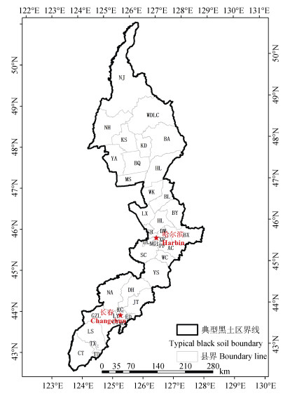
图1东北典型黑土区行政区划图
NJ:嫩江县; WDLC:五大连池市; BA:北安市; NH:讷河市; KS:克山县; KD:克东县; YA:依安县; BQ:拜泉县; HL:海伦市; MS:明水县; WK:望奎县; BL:北林区; BY:巴彦县; LX:兰西县; HL:呼兰区; SB:松北区; DW:道外区; BX:宾县; XF:香坊区; DL:道里区; NG1:南岗区; PF:平房区; AC:阿城区; SC:双城市; WC:五常市; YS:榆树市; DH:德惠市; NA:农安县; JT:九台市; KC:宽城区; LY:绿园区; GZL:公主岭市; ED:二道区; NG:南关区; CY:朝阳区; LS:梨树县; TX:铁西区; TD:铁东区; CT:昌图县。
Figure1.Administrative map of the typical black soil region in Northeast China
NJ: Nenjiang County; WDLC: Wudalianchi City; BA: Bei'an City; NH: Nehe City; KS: Keshan County; KD: Kedong County; YA: Yi'an County; BQ: Baiquan County; HL: Hailun City; MS: Mingshui County; WK: Wangkui County; BL: Beilin District; BY: Bayan County; LX: Lanxi County; HL: Hulan District; SB: Songbei District; DW: Daowai District; BX: Binxian County; XF: Xiangfang District; DL: Daoli District; NG1: Nangang District; PF: Pingfang District; AC: Acheng District; SC: Shuangcheng City; WC: Wuchang City; YS: Yushu City; DH: Dehui City; NA: Nong'an County; JT: Jiutai City; KC: Kuancheng District; LY: Luyuan District; GZL: Gongzhuling City; ED: Erdao District; NG: Nanguan District; CY: Chaoyang District; LS: Lishu County; TX: Tiexi District; TD: Tiedong District; CT: Changtu County.
 下载: 全尺寸图片幻灯片
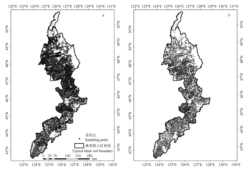
图22018年(a)和2008年(b)东北典型黑土区采样点分布图
Figure2.Sampling points distribution map of typical black soil in Northeast China in 2018 (a) and 2008 (b)
下载: 全尺寸图片幻灯片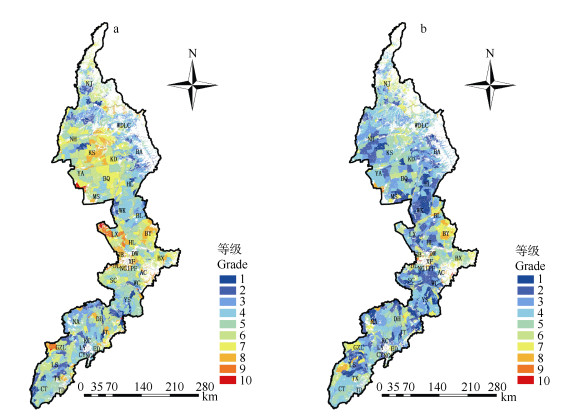
图32008年(a)和2018年(b)东北典型黑土区耕地质量等级空间分布图
各地区字母含义见图 1。
Figure3.Distribution of cultivated land quality grades in the typical black soil areas in Northeast China in 2008 (a) and 2018(b)
The meaning of the region letters were shown in the Fig. 1
下载: 全尺寸图片幻灯片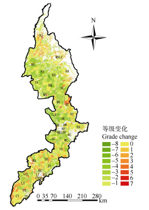
图42008—2018年间东北典型黑土区耕地质量等级变化分布图
各地区字母含义见图 1。
Figure4.Distribution of changes of cultivated land quality grades in the typical black soil region of Northeast China from 2008 to 2018
The meaning of the region letters were shown in the Fig. 1.
下载: 全尺寸图片幻灯片表1东北典型黑土区耕地质量评价指标体系及指标权重
Table1.Indexes and weights of cultivated land quality evaluation system of the typical black soil region in Northeast China
| 目标层 Objective | 准则层 Criterion | 权重 Weight | 指标层 Index | 组合权重 Combination weight |
| 耕地质量 Cultivated land quality | 立地条件 Site condition | 0.171 9 | 地形部位Terrain position | 0.106 2 |
| 农田林网化程度Degree of field forest network | 0.065 7 | |||
| 剖面性状 Profile characteristics | 0.246 9 | 有效土层厚度Effective soil layer thickness | 0.082 3 | |
| 质地构型Texture configuration | 0.059 1 | |||
| 耕层理化性状 Arable layer physical and chemical property | 0.184 4 | 障碍因素Obstacle factor | 0.055 2 | |
| 耕层厚度Arable layer thickness | 0.050 3 | |||
| 耕层质地Arable layer texture | 0.076 2 | |||
| 土壤容重Soil bulk density | 0.044 1 | |||
| pH | 0.064 1 | |||
| 养分状况 Nutrient status | 0.165 6 | 有机质Organic matter | 0.068 3 | |
| 有效磷Available P | 0.053 8 | |||
| 速效钾Available K | 0.043 5 | |||
| 健康状况 Health status | 0.071 9 | 生物多样性Biodiversity | 0.036 5 | |
| 清洁程度Cleaning degree | 0.035 3 | |||
| 土壤管理 Soil management | 0.159 4 | 灌溉能力Irrigation capacity | 0.109 9 | |
| 排水能力Drainage capability | 0.049 5 |
下载: 导出CSV表2东北典型黑土区耕地质量评价定量指标隶属函数
Table2.Membership functions of quantitative indexes of cultivated land quality evaluation in the typical black soil region of Northeast China
| 函数类型Function type | 指标Index | 隶属函数Function | C | Ut |
| 戒上型Upper limit | 有效土层厚度Effective soil layer thickness (cm) | Y=1/[1+ 0.000 213×(U-C)2] | 100.002 147 | Ut1= 0, Ut2=100.002 147 |
| 戒上型Upper limit | 耕层厚度Arable layer thickness (cm) | Y=1/[1+ 0.002 322×(U-C)2] | 30.006 247 | Ut1= 0, Ut2=30.006 247 |
| 戒上型Upper limit | 有机质Organic matter (g·kg-1) | Y=1/[1+ 0.000 446×(U-C)2] | 60.000 048 | Ut1= 0, Ut2=60.000 048 |
| 戒上型Upper limit | 有效磷Available P (mg·kg-1) | Y=1/[1+ 0.000 396×(U-C)2] | 60.009 908 | Ut1= 0, Ut2=60.009 908 |
| 戒上型Upper limit | 速效钾Available K (mg·kg-1) | Y=1/[1+ 0.000 014×(U-C)2] | 300.084 871 | Ut1= 0, Ut2=300.084 871 |
| 峰型Peak | pH | Y=1/[1+ 0.209 720×(U-C)2] | 6.776 050 | Ut1= 0.22, Ut2=13.32 |
| 峰型Peak | 土壤容重Soil bulk density (g·cm-3) | Y=1/[1+ 8.696 016×(U-C)2] | 1.242 811 | Ut1= 0.22, Ut2=2.26 |
| Y表示指标隶属度, U表示样品观测值, C表示指标标准值, Ut1、Ut2表示指标下、上限值。Y indicates membership degree of index. U indicates sample observation value. C indicates standard value of index.Ut1 and Ut2 indicate the lower and upper limit value of index. | ||||
下载: 导出CSV表3东北典型黑土区耕地质量评价定性指标隶属度
Table3.Membership degrees of qualitative indexes of cultivated land quality evaluation in the typical black soil region of Northeast China
| 评价指标 Evaluation index | 属性 Attribute | 隶属度 Membership degree |
| 地形部位 Terrain position | 平原中阶Middle plain terrace | 1.00 |
| 宽谷盆地Broad valley basin | 0.96 | |
| 平原高阶Upper plain terrace | 0.89 | |
| 丘陵下部Lower part of hill | 0.78 | |
| 丘陵中部Middle part of hill | 0.77 | |
| 平原低阶Lower plain terrace | 0.75 | |
| 山间盆地Intermontane basin | 0.74 | |
| 山地坡下Lower part of mountain slope | 0.64 | |
| 丘陵上部Upper part of hill | 0.59 | |
| 山地坡中Middle part of mountain slope | 0.54 | |
| 山地坡上Upper part of mountain slope | 0.43 | |
| 质地构型 Texture configuration | 上松下紧型Upper loose lower tight | 1.00 |
| 海绵型Spongy | 0.94 | |
| 夹层型Sandwich | 0.63 | |
| 紧实型Compact | 0.59 | |
| 上紧下松型Upper tight lower loose | 0.53 | |
| 薄层型Thin layer | 0.52 | |
| 松散型Loose | 0.38 | |
| 灌溉能力 Irrigation capacity | 充分满足Fully satisfy | 1.00 |
| 满足Satisfy | 0.85 | |
| 基本满足Basically satisfy | 0.61 | |
| 不满足Not satisfy | 0.40 | |
| 清洁程度 Cleaning degree | 清洁Cleaning | 1.00 |
| 尚清洁Still cleaning | 0.72 | |
| 障碍因素 Obstacle factor | 无Nothing | 1.00 |
| 障碍层次Obstacle layer | 0.71 | |
| 渍潜Waterlog | 0.65 | |
| 瘠薄Barren | 0.56 | |
| 酸化Acidification | 0.55 | |
| 盐碱Saline-alkaline | 0.40 | |
| 耕层质地 Arable layer texture | 中壤Medium loam | 1.00 |
| 轻壤Light loam | 0.88 | |
| 重壤Heavy loam | 0.84 | |
| 砂壤Sandy loam | 0.71 | |
| 黏土Clay soil | 0.60 | |
| 砂土Sandy soil | 0.48 | |
| 生物多样性 Biodiversity | 丰富Abundant | 1.00 |
| 一般General | 0.69 | |
| 不丰富Deficient | 0.41 | |
| 农田林网化程度 Degree of field forest network | 高High | 1.00 |
| 中Middle | 0.79 | |
| 低Low | 0.53 | |
| 排水能力 Drainage capability | 充分满足Fully satisfy | 1.00 |
| 满足Satisfy | 0.83 | |
| 基本满足Basically satisfy | 0.59 | |
| 不满足Not satisfy | 0.30 |
下载: 导出CSV表4东北典型黑土区耕地质量综合指数分级
Table4.Classification of comprehensive index of cultivated land quality in typical black soil areas in Northeast China
| 耕地质量 Cultivated land quality | 等级 Grade | 耕地质量综合指数 Integrated fertility index |
| 高等 High quality | 1 | > 0.828 4 |
| 2 | 0.807 0~0.828 4 | |
| 3 | 0.785 6~0.807 0 | |
| 中等 Medium quality | 4 | 0.764 2~0.785 6 |
| 5 | 0.742 8~0.764 2 | |
| 6 | 0.721 4~0.742 8 | |
| 低等 Low quality | 7 | 0.700 0~0.721 4 |
| 8 | 0.678 6~0.700 0 | |
| 9 | 0.657 2~0.678 6 | |
| 10 | ≤0.657 2 |
下载: 导出CSV表52008和2018年东北典型黑土区不同质量等级耕地面积及占比
Table5.Areas and proportions of different quality grades of cultivated land in the typical black soil areas in Northeast China in 2008 and 2018
| 等级 Grade | 2008 | 2018 | ||||
| 面积 Area (104hm2) | 占比 Percent (%) | 面积 Area (104hm2) | 占比 Percent (%) | |||
| 高等地 High level | 1 | 26.72 | 3.22 | 63.26 | 7.62 | |
| 2 | 39.34 | 4.73 | 113.94 | 13.72 | ||
| 3 | 75.08 | 9.04 | 163.95 | 19.75 | ||
| 中等地 Medium level | 4 | 147.09 | 17.72 | 201.79 | 24.30 | |
| 5 | 185.92 | 22.39 | 146.12 | 17.60 | ||
| 6 | 167.78 | 20.21 | 70.56 | 8.50 | ||
| 低等地 Low level | 7 | 116.72 | 14.06 | 50.73 | 6.11 | |
| 8 | 55.43 | 6.68 | 17.35 | 2.09 | ||
| 9 | 13.22 | 1.59 | 2.22 | 0.27 | ||
| 10 | 2.96 | 0.36 | 0.34 | 0.04 | ||
| 总计Total | 830.26 | 100.00 | 830.26 | 100.00 | ||
| 平均质量等级 Average grade | 5.14 | 3.92 | ||||
下载: 导出CSV表62008—2018年间东北典型黑土区耕地质量等级变化面积对比
Table6.Comparison of area changes of cultivated land quality grades in the typical black soil region of Northeast China from 2008 to 2018
| 等级变化 Grade change | 面积 Area (104hm2) | 占比 Percentage (%) |
| -8 | 0.01 | 0.00 |
| -7 | 2.20 | 0.27 |
| -6 | 8.48 | 1.02 |
| -5 | 22.10 | 2.66 |
| -4 | 66.74 | 8.04 |
| -3 | 116.99 | 14.09 |
| -2 | 140.51 | 16.92 |
| -1 | 183.11 | 22.05 |
| 0 | 136.79 | 16.48 |
| 1 | 89.95 | 10.83 |
| 2 | 37.22 | 4.48 |
| 3 | 17.03 | 2.05 |
| 4 | 5.93 | 0.71 |
| 5 | 2.88 | 0.35 |
| 6 | 0.24 | 0.03 |
| 7 | 0.08 | 0.01 |
| 等级变化负值表示耕地质量等级提升, 正值表示等级下降。The negative values of grade change means increase of cultivated land quality, while positive value means the decline of cultivated land quality grade. | ||
下载: 导出CSV表7东北典型黑土区不同等级耕地典型地块实地调查信息对照
Table7.Field survey information of typical plots of different quality grades of cultivated land in the typical black soil region of Northeast China
| 地点 Location | 评价等级 Grade | 有效磷 Available P (mg·kg-1) | 有效土层厚度 Effective soil layer thickness (cm) | 耕层厚度 Arable layer thickness (cm) | 地形部位 Terrain position | pH | 灌溉能力 Irrigation capacity | 有机质 Organic matter (g·kg-1) | 耕层质地 Arable layer texture |
| 梨树县Lishu County | 1 | 60.86 | 100 | 22.00 | 平原中阶Middle plain terrace | 7.24 | 满足Satisfy | 35.15 | 中壤Medium loam |
| 兰西县Lanxi County | 2 | 48.99 | 96 | 17.25 | 平原中阶Middle plain terrace | 7.51 | 满足Satisfy | 27.40 | 中壤Medium loam |
| 望奎县Wangkui County | 3 | 43.64 | 100 | 18.90 | 丘陵下部Lower part of hill | 6.97 | 基本满足Basically satisfy | 37.40 | 重壤Heavy loam |
| 嫩江县Nenjiang County | 4 | 56.41 | 70 | 20.01 | 丘陵中部Middle part of hill | 5.76 | 不满足Not satisfy | 55.83 | 重壤Heavy loam |
| 拜泉县Baiquan County | 5 | 54.67 | 79 | 24.73 | 平原低阶Lower plain terrace | 6.60 | 不满足Not satisfy | 39.85 | 重壤Heavy loam |
| 榆树市Yushu City | 6 | 33.72 | 85 | 20.19 | 平原低阶Lower plain terrace | 5.42 | 基本满足Basically satisfy | 25.23 | 中壤Medium loam |
| 农安县Nong’an County | 7 | 15.67 | 90 | 18.23 | 平原低阶Lower plain terrace | 7.80 | 不满足Not satisfy | 28.86 | 重壤Heavy loam |
| 巴彦县Bayan County | 8 | 86.71 | 45 | 15.41 | 丘陵上部Upper part of hill | 5.64 | 不满足Not satisfy | 37.26 | 重壤Heavy loam |
| 北林区Beilin District | 9 | 17.28 | 34 | 14.80 | 平原低阶Lower plain terrace | 5.46 | 基本满足Basically satisfy | 30.34 | 黏土Clay soil |
| 松北区Songbei District | 10 | 30.23 | 27 | 18.89 | 平原低阶Lower plain terrace | 5.64 | 不满足Not satisfy | 29.65 | 砂壤Sandy loam |
下载: 导出CSV参考文献
| [1] | 鲁明星, 贺立源, 吴礼树.我国耕地地力评价研究进展[J].生态环境, 2006, 15(4):866-871 doi: 10.3969/j.issn.1674-5906.2006.04.040 LU M X, HE L Y, WU L S. Fertility evaluation of cultivated land in China:A review[J]. Ecology and Environment, 2006, 15(4):866-871 doi: 10.3969/j.issn.1674-5906.2006.04.040 |
| [2] | 魏丹, 杨谦, 迟凤琴.东北黑土区土壤资源现状与存在问题[J].黑龙江农业科学, 2006(6):69-72 doi: 10.3969/j.issn.1002-2767.2006.06.024 WEI D, YANG Q, CHI F Q. The soil resource conditions and the problems in Northeast black soil regions[J]. Heilongjiang Agricultural Sciences, 2006(6):69-72 doi: 10.3969/j.issn.1002-2767.2006.06.024 |
| [3] | 韩长斌.加强东北黑土地保护推进农业绿色发展[N].人民日报, 2018-02-05 HAN C B. Strengthening the protection of black soil in Northeast China and promoting agricultural green development[N]. People's Daily, 2018-02-05 |
| [4] | 韩晓增, 李娜.中国东北黑土地研究进展与展望[J].地理科学, 2018, 38(7):1032-1041 http://www.wanfangdata.com.cn/details/detail.do?_type=perio&id=dlkx201807004 HAN X Z, LI N. Research progress of black soil in Northeast China[J]. Scientia Geographica Sinica, 2018, 38(7):1032-1041 http://www.wanfangdata.com.cn/details/detail.do?_type=perio&id=dlkx201807004 |
| [5] | HAO C L, XIAO W H, ZHOU Y Y, et al. Phosphorus balance in typical rainfield of black soil region in Northeast China[J]. Geosciences Journal, 2019, 23(4):637-648 doi: 10.1007/s12303-018-0069-1 |
| [6] | 曹野.东北地区耕地质量等级评价与现状分析[D].沈阳: 沈阳农业大学, 2017 http://cdmd.cnki.com.cn/Article/CDMD-10157-1017123066.htm CAO Y. Cultivated land quality evaluation and present situation analysis in Northeast China[D]. Shenyang: Shenyang Agricultural University, 2017 http://cdmd.cnki.com.cn/Article/CDMD-10157-1017123066.htm |
| [7] | 韩晓增, 邹文秀.我国东北黑土地保护与肥力提升的成效与建议[J].中国科学院院刊, 2018, 33(02):206-212 http://d.old.wanfangdata.com.cn/Periodical/zgkxyyk201802013 HAN X Z, ZOU W X. Effects and suggestions of black soil protection and soil fertility increase in Northeast China[J]. Bulletin of Chinese Academy of Sciences, 2018, 33(2):206-212 http://d.old.wanfangdata.com.cn/Periodical/zgkxyyk201802013 |
| [8] | DONG Y F, WU Y Q, QIN W, et al. The gully erosion rates in the black soil region of northeastern China:Induced by different processes and indicated by different indexes[J]. Catena, 2019, 182:104146 doi: 10.1016/j.catena.2019.104146 |
| [9] | 贾利.东北黑土带土地资源可持续发展问题与对策研究[J].中国农学通报, 2005, 21(4):352-354 doi: 10.3969/j.issn.1000-6850.2005.04.098 JIA L. Issues and some strategies of sustainable development of black soil resources in black soil zone in Northeast China[J]. Chinese Agricultural Science Bulletin, 2005, 21(4):352-354 doi: 10.3969/j.issn.1000-6850.2005.04.098 |
| [10] | 刘丙友.典型黑土区土壤退化及可持续利用问题探讨[J].中国水土保持, 2003(12):28-29 doi: 10.3969/j.issn.1000-0941.2003.12.014 LIU B Y. Discussion on soil degradation and sustainable utilization in the typical black soil region[J]. Soil and Water Conservation in China, 2003(12):28-29 doi: 10.3969/j.issn.1000-0941.2003.12.014 |
| [11] | LIU X B, ZHANG X Y, WANG Y X, et al. Soil degradation:a problem threatening the sustainable development of agriculture in Northeast China[J]. Plant Soil Environment, 2010, 56(2):87-97 doi: 10.17221/155/2009-PSE |
| [12] | 鲍士旦.土壤农化分析[M].北京:中国农业出版社, 2000:60-63 BAO S D. Soil and Agricultural Chemistry Analysis[M]. Beijing:China Agriculture Press, 2000:60-63 |
| [13] | 白根川, 王昌全, 夏建国, 等.基于GIS技术的平昌县域耕地地力评价[J].中国农学通报, 2012, 28(29):212-220 doi: 10.3969/j.issn.1000-6850.2012.29.044 BAI G C, WANG C Q, XIA J G, et al. Evaluation of farmland productivity in Pingchang County based on GIS technology[J]. Chinese Agricultural Science Bulletin, 2012, 28(29):212-220 doi: 10.3969/j.issn.1000-6850.2012.29.044 |
| [14] | 刘京, 常庆瑞, 陈涛, 等.黄土高原南缘土石山区耕地地力评价研究[J].中国生态农业学报, 2010, 18(2):229-234 http://d.old.wanfangdata.com.cn/Periodical/stnyyj201002002 LIU J, CHANG Q R, CHEN T, et al. Evaluation of farmland productivity on the earth and rocky area of the South Loess Plateau[J]. Chinese Journal of Eco-Agriculture, 2010, 18(2):229-234 http://d.old.wanfangdata.com.cn/Periodical/stnyyj201002002 |
| [15] | 余笑眉.松阳县耕地地力评价与空间变异研究[D].杭州: 浙江农林大学, 2010 http://kns.cnki.net/KCMS/detail/detail.aspx?dbcode=CMFD&filename=1011026886.nh YU X M. Land fertility evaluation and its spatial variability: A case study of Songyang County[D]. Hangzhou: Zhejiang A & F University, 2010 http://kns.cnki.net/KCMS/detail/detail.aspx?dbcode=CMFD&filename=1011026886.nh |
| [16] | 张勤才, 马友华, 杨生华, 等.基于GIS的芜湖市耕地地力评价[J].长江流域资源与环境, 2016, 25(2):226-233 http://d.old.wanfangdata.com.cn/Periodical/cjlyzyyhj201602007 ZHANG Q C, MA Y H, YANG S H, et al. Evaluation of cultivated land fertility in Wuhu City based on GIS[J]. Resources and Environment in the Yangtze Basin, 2016, 25(2):226-233 http://d.old.wanfangdata.com.cn/Periodical/cjlyzyyhj201602007 |
| [17] | 樊燕.梁平县耕地地力评价研究[D].重庆: 西南大学, 2008 http://cdmd.cnki.com.cn/Article/CDMD-10635-2008094376.htm FAN Y. Evaluation of cultivated land productivity in Liangping County[D]. Chongqing: Southwest University, 2008 http://cdmd.cnki.com.cn/Article/CDMD-10635-2008094376.htm |
| [18] | 汤国安, 杨昕. ArcGIS地理信息系统空间分析实验教程[M].北京:科学出版社, 2006:372-373 TANG G A, YANG X. The Experiments Tutorial of Spatial Analysis of ArcGIS Geographic Information System[M]. Beijing:Science Press, 2006:372-373 |
| [19] | 国家质量监督检验检疫总局. GB/T33469-2016耕地质量等级[S].北京: 中国标准出版社, 2016 General Administration of Quality Supervision, Inspection and Quarantine of the People's Republic of China. GB/T33469-2016 Cultivated Land Quality Grade[S]. Beijing: Standard Press of China, 2016 |
| [20] | 危向峰, 段建南, 胡振琪, 等.层次分析法在耕地地力评价因子权重确定中的应用[J].湖南农业科学, 2006(2):39-42 doi: 10.3969/j.issn.1006-060X.2006.02.018 WEI X F, DUAN J N, HU Z Q, et al. Applying analytic hierarchy process to determining farmland productivity evaluation factors' weight[J]. Hunan Agricultural Sciences, 2006(2):39-42 doi: 10.3969/j.issn.1006-060X.2006.02.018 |
| [21] | 耕地质量建设和保护有"标杆"了——《耕地质量等级》国家标准解读[J].中国农业信息, 2017, (8): 5-10 http://www.cnki.com.cn/Article/CJFDTotal-JNYZ201703081.htm Standard for the quality construction and protection of cultivated land-Interpretation of the national standard of "Cultivated Land Quality Grade"[J]. China Agricultural Informatics, 2017, (8): 5-10 http://www.cnki.com.cn/Article/CJFDTotal-JNYZ201703081.htm |
| [22] | DOUSARI A, MISAK A M, SHAHID R S. Soil compaction and sealing in AL-Salmi area, western Kuwaut[J]. Land Degradation and Development, 2000, 11(05):401-418 doi: 10.1002/1099-145X(200009/10)11:5<401::AID-LDR396>3.0.CO;2-4 |
| [23] | 杨瑞珍, 陈印军.东北地区耕地质量状况及变化态势分析[J].中国农业资源与区划, 2014, 35(6):19-24 http://d.old.wanfangdata.com.cn/Periodical/zgnyzyyqh201406003 YANG R Z, CHEN Y J. Analysis of quality of cultivated and land change trend in Northeast area[J]. Chinese Journal of Agricultural Resources and Regional Planning, 2014, 35(6):19-24 http://d.old.wanfangdata.com.cn/Periodical/zgnyzyyqh201406003 |
| [24] | 霍俊宇, 何文杰.黑龙江省黑土保护性耕作政策实施效果评价[J].南方农机, 2018, 49(12):4-5 doi: 10.3969/j.issn.1672-3872.2018.12.005 HUO J Y, HEN W J. Evaluation of implementation effect of black soil conservation tillage policy in Heilongjiang Province[J]. China Southern Agricultural Machinery, 2018, 49(12):4-5 doi: 10.3969/j.issn.1672-3872.2018.12.005 |
| [25] | 韩晓增, 邹文秀, 严君, 等.农田生态学和长期试验示范引领黑土地保护和农业可持续发展[J].中国科学院院刊, 2019, 34(3):362-370 http://d.old.wanfangdata.com.cn/Periodical/zgkxyyk201903018 HAN X Z, ZOU W X, YAN J, et al. Ecology in agriculture and long-term research guide protection of black soil and agricultural sustainable development in Northeast China[J]. Bulletin of Chinese Academy of Sciences, 2019, 34(3):362-370 http://d.old.wanfangdata.com.cn/Periodical/zgkxyyk201903018 |
