杨爱民,
夏鑫鑫,
武红旗
新疆农业大学草业与环境科学学院/新疆土壤与植物生态过程实验室 乌鲁木齐 830052
基金项目: 国家自然科学基金项目41561019
国家自然科学基金项目41561103
详细信息
作者简介:朱磊, 主要研究方向为地理信息系统和遥感应用研究。E-mail:smartzhulei04@163.com
中图分类号:P967;F301.24计量
文章访问数:360
HTML全文浏览量:3
PDF下载量:394
被引次数:0
出版历程
收稿日期:2019-09-03
录用日期:2020-02-08
刊出日期:2020-06-01
Spatial distribution pattern and change characteristics analysis of cultivated land in the Manas River Basin from 1975 to 2015
ZHU Lei,,YANG Aimin,
XIA Xinxin,
WU Hongqi
College of Grassland and Environmental Sciences, Xinjiang Agricultural University/Xinjiang Key Laboratory of Soil and Plant Ecological Processes, Urumqi 830052, China
Funds: the National Natural Science Foundation of China41561019
the National Natural Science Foundation of China41561103
More Information
Corresponding author:ZHU Lei, E-mail: smartzhulei04@163.com
摘要
HTML全文
图
参考文献
相关文章
施引文献
资源附件
访问统计
摘要
摘要:为揭示耕地空间分布特征与变化趋势,本研究以玛纳斯河流域为例,基于7期(1975年、1990年、1995年、2000年、2005年、2010年和2015年)土地利用数据提取流域耕地信息,采用空间自相关、重心模型、标准差椭圆、地学信息图谱等方法,分析1975-2015年流域耕地空间格局演变特征。结果表明:耕地空间分布存在显著全局正相关,局部空间异质性较强,耕地在时间序列上呈现先减弱后增强再减弱的集聚态势,最终形成以沙湾县商户地乡与石河子市北泉镇为左、右核心的"高-高"集聚分布。耕地空间变化总体呈现西北方向的明显偏移,耕地重心迁移速度经历"缓慢(1975-1995年)-加速(1995-2005年)-减速(2005-2015年)"过程。1995年后标准差椭圆空间分布格局在西北方向愈加明显,椭圆面积大幅增长,耕地涨幅不断增强,并有继续向流域北部荒漠区扩张的趋势。LISA频率图谱中稳定不变与低频区域占比合计达84.58%,耕地空间格局相对稳定。1975-2015年耕地聚集状态主要变化特征表现为"低-低"集聚和"低-高"集聚向"高-高"集聚的转变,流域耕地呈现高密度扩增式发展。通过构建LISA频率图谱,结合重心模型与标准差椭圆较为全面地、动态地掌握了区域耕地空间演变趋势,为耕地资源的科学管理与有效保护提供理论基础与决策依据。
Abstract:The objective of this study was to reveal the spatial distribution characteristics and change trend of cultivated land, taking the Manas River as the study area, by extracting the cultivated land information based on 1975, 1990, 1995, 2000, 2005, 2010, and 2015 series of land use data, via spatial autocorrelation, gravity center mode, standard deviational ellipse, and geography informatic spectrum analysis. The results revealed that there was significant global positive correlation and strong local spatial heterogeneity in the spatial distribution of cultivated land. The cultivated land showed an aggregated time series trend, which first weakened, then strengthened, and then weakened again across the study period. The land formed a high-high agglomerate distribution situation with a left core in Shanghudi Township of Shawan County, and a right core in Beiquan Town of Shihezi City. The overall spatial change in the cultivated land showed a clear, significant shift to the northwest, and the moving speed of the cultivated land's center of gravity experienced a process of "slowed (1975-1995)-accelerated (1995-2005)-decelerated (2005-2015)". The spatial distribution pattern of the standard deviation ellipse appeared more obvious in the northwest direction after 1995, and the area of ellipse increased substantially. The growth range of the cultivated land was constantly strengthened and had a trend of expansion to the northern desert area of the basin. Through LISA frequency geo-spectrum analysis, we found that the total proportions of stable invariant and low frequency types accounted for 84.58%, and the spatial pattern of cultivated land was relatively stable. The overall spatial aggregation of the cultivated land generally shifted from a state of "Low-Low" aggregation "Low-High" aggregation to a state of "High-High" aggregation, which showed high-density expansion of cultivated land in the Manas River Basin from 1975 to 2015. By constructing the geo-spectrum of LISA frequency and combining the gravity center model and standard deviation ellipse, spatial evolution trends in the regional cultivated land were comprehensively and dynamically outlined, and the theoretical basis and decision-making foundations for scientific management and effective protection of cultivated land resources were provided.
HTML全文
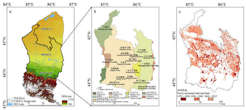
图1玛纳斯河流域数字高程和地理单元分区(a)、行政区划(b)及1975—2015年耕地扩张趋势(c)
Figure1.Digital elevation and geographic unit partition (a), administrative district (b), and the trend of cultivated land expansion from 1975 to 2015 (c) of the Manas River Basin
 下载: 全尺寸图片幻灯片
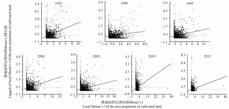
图21975—2015年玛纳斯河流域行政村耕地面积比例局部Moran’s I指数散点图
Figure2.Scatter-plots of local Moran's I for the areal proportion of cultivated land at village level in the Manas River Basin from 1975 to 2015
下载: 全尺寸图片幻灯片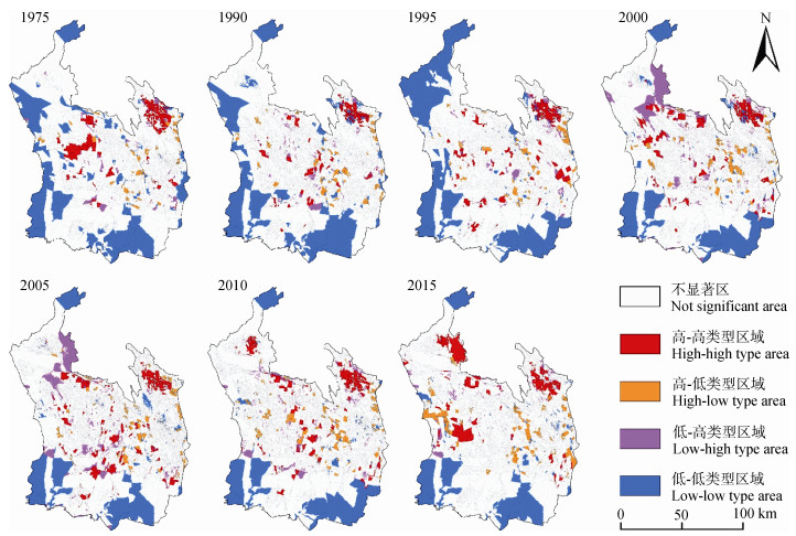
图31975—2015年玛纳斯河流域耕地面积比例LISA集聚图
Figure3.LISA plots for the areal proportion of cultivated land in the Manas River Basin during 1975-2015
下载: 全尺寸图片幻灯片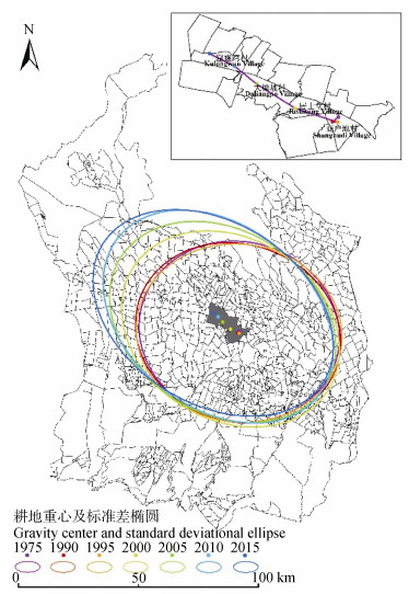
图41975—2015年玛纳斯河流域耕地重心及标准差椭圆分布
Figure4.Distribution of cultivated land centers and standard deviational ellipses of cultivated land of the Manas River Basin from 1975 to 2015
下载: 全尺寸图片幻灯片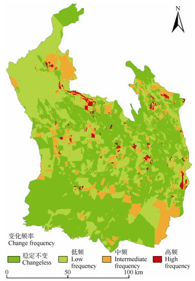
图51975—2015年玛纳斯河流域耕地LISA频率图谱分析
Figure5.Analysis of LISA frequency geo-spectrum of cultivated land in the Manas River Basin during 1975–2015
下载: 全尺寸图片幻灯片表11975—2015年玛纳斯河流域耕地面积比例值的全局Moran’s I指数与检验
Table1.Global Moran's I and tests for the areal proportion of cultivated land in the Manas River Basin during 1975—2015
| 年份Year | 1975 | 1990 | 1995 | 2000 | 2005 | 2010 | 2015 |
| Moran’s I | 0.219 1 | 0.093 8 | 0.112 1 | 0.133 8 | 0.106 3 | 0.082 4 | 0.076 6 |
| Zscore | 20.406 1 | 9.376 2 | 11.879 0 | 13.693 2 | 14.405 3 | 10.199 7 | 8.719 6 |
下载: 导出CSV表21975—2015年玛纳斯河流域耕地重心迁移
Table2.Shift of cultivated land gravity center of the Manas River Basin during 1975-2015
| 重心迁移 Shift of gravity center | 时段Period | |||||
| 1975—1990 | 1990—1995 | 1995—2000 | 2000—2005 | 2005—2010 | 2010—2015 | |
| 移动方向Moving direction | 西南 Southwest | 偏东 East | 西北 Northwest | 西北 Northwest | 西北 Northwest | 西北 Northwest |
| 移动距离Movement distance (km) | 0.898 7 | 0.630 7 | 5.385 2 | 5.452 2 | 3.465 8 | 3.349 4 |
| 移动速度Movement speed (km·a-1) | 0.059 9 | 0.126 1 | 1.077 0 | 1.090 4 | 0.693 2 | 0.669 9 |
下载: 导出CSV表31975—2015年玛纳斯河流域耕地标准差椭圆参数变化
Table3.Cultivated land standard deviational ellipses of cultivated land of the Manas River Basin during 1975-2015
| 年份Year | 1975 | 1990 | 1995 | 2000 | 2005 | 2010 | 2015 |
| 转角Rotation θ (°) | 104.425 | 108.623 | 97.845 | 121.488 | 122.057 | 127.977 | 121.981 |
| 沿x轴标准差 Standard deviation along the x-axis (km) | 42.051 | 43.420 | 43.005 | 47.963 | 50.296 | 53.132 | 54.212 |
| 沿y轴标准差 Standard deviation along the y-axis (km) | 37.342 | 36.819 | 37.023 | 37.772 | 37.970 | 37.908 | 37.667 |
| 椭圆面积Ellipse area (km2) | 4 932.907 | 5 022.079 | 5 001.782 | 5 691.215 | 5 999.245 | 6 327.086 | 6 414.728 |
下载: 导出CSV表41975—2015年玛纳斯河流域耕地LISA频率图谱特征
Table4.Characteristics of LISA frequency geo-spectrum of cultivated land in the Manas River Basin from 1975 to 2015
| 频率图谱 Geo-spectrum of frequency | 空间集聚转变次数 Times of spatial agglomeration changes | 面积 Area (km2) | 最大变化Maximum change | ||
| 最大图谱单元类型 Maximum map unit type | 面积 Area (km2) | 变化比率 Change ratio (%) | |||
| 稳定不变 Stable invariant | 0 | 7 858.76 | NS | 6 132.01 | 0.00 |
| LL | 1 631.43 | 0.00 | |||
| 低频 Low-frequency | 1~2 | 5 694.97 | NS转向LL NS turn to LL | 957.69 | 11.73 |
| LL转向NS LL turn to NS | 533.02 | 6.53 | |||
| 中频 Intermediate frequency | 3~4 | 2 212.88 | NS与LL相互转换Conversion between NS and LL | 359.71 | 4.40 |
| NS转向LH、HH NS turn to LH and HH | 181.96 | 2.23 | |||
| 高频 High frequency | 5~6 | 258.10 | LL转向LH LL turn to LH | 27.47 | 0.34 |
| NS与HL相互转换Conversion between NS and HH | 17.51 | 0.21 | |||
| HH:高-高集聚; LL:低-低集聚; LH:低高集聚; HL:高-低集聚; NS:不显著. HH: high-high agglomeration; LL: low-low agglomeration; LH: low-high agglomeration; HL: high-low agglomeration; NS: not significant. | |||||
下载: 导出CSV参考文献
| [1] | ?áLEK M, HULA V, KIPSON M, et al. Bringing diversity back to agriculture:Smaller fields and non-crop elements enhance biodiversity in intensively managed arable farmlands[J]. Ecological Indicators, 2018, 90:65-73 http://cn.bing.com/academic/profile?id=c3ac74f3ab27d63ee06277a29d6740e0&encoded=0&v=paper_preview&mkt=zh-cn |
| [2] | 孙聪康, 徐俊丽, 余敦, 等.多尺度下崇义县耕地质量空间分布差异特征研究[J].中国生态农业学报(中英文), 2019, 27(4):601-612 http://d.old.wanfangdata.com.cn/Periodical/stnyyj201904011 SUN C K, XU J L, YU D, et al. Spatial distribution of cultivated land quality at different scales in Chongyi County[J]. Chinese Journal of Eco-Agriculture, 2019, 27(4):601-612 http://d.old.wanfangdata.com.cn/Periodical/stnyyj201904011 |
| [3] | BULGAKOV D S, RUKHOVICH D I, SHISHKONAKOVA E A, et al. The application of soil-agroclimatic index for assessing the agronomic potential of arable lands in the forest-steppe zone of Russia[J]. Eurasian Soil Science, 2018, 51(4):448-459 http://www.wanfangdata.com.cn/details/detail.do?_type=perio&id=c67493110ede0e90d123bae15c92e355 |
| [4] | 加拉力丁·比拉力, 王晓君, 石敏俊.分析现代绿洲扩张驱动力与绿洲生态风险管理研究——以新疆焉耆绿洲为例[J].管理评论, 2016, 28(6):162-168 http://www.wanfangdata.com.cn/details/detail.do?_type=perio&id=glpl201606016 JALALIDING·BILALI, WANG X J, SHI M J. Analysis of driving forces of oasis expansion and ecological risk management-A case study of Yanqi Oasis of Xinjiang, China[J]. Management Review, 2016, 28(6):162-168 http://www.wanfangdata.com.cn/details/detail.do?_type=perio&id=glpl201606016 |
| [5] | YANG Y T, YANG J H, WEI S L. The estimation of cultivated land threshold value in Hotan Oasis[J]. Agricultural Science & Technology, 2016, 17(5):1161-1165 http://www.wanfangdata.com.cn/details/detail.do?_type=perio&id=hnnykjtx-e201605030 |
| [6] | 张志军, 伍维模, 张宏.塔里木河中游耕地扩张及景观破碎化研究[J].地理空间信息, 2018, 16(8):19-23 http://d.old.wanfangdata.com.cn/Periodical/dlkjxx201808006 ZHANG Z J, WU W M, ZHANG H. Farmland expansion and landscape fragmentation in the middle reaches of Tarim River[J]. Geospatial Information, 2018, 16(8):19-23 http://d.old.wanfangdata.com.cn/Periodical/dlkjxx201808006 |
| [7] | 张琪, 罗格平, 李龙辉, 等.基于土地利用/覆被变化表征的现代绿洲演变过程——以天山北坡三工河流域为例[J].地理学报, 2016, 71(7):1157-1171 ZHANG Q, LUO G P, LI L H, et al. Modern oasis evolution analysis based on land-use and land-cover change:A case study in Sangong River Basin on the northern slope of Tianshan Mountains[J]. Acta Geographica Sinica, 2016, 71(7):1157-1171 |
| [8] | WEI H J, LIU H M, XU Z H, et al. Linking ecosystem services supply, social demand and human well-being in a typical mountain-oasis-desert area, Xinjiang, China[J]. Ecosystem Services, 2018, 31:44-57 http://cn.bing.com/academic/profile?id=cbceb87dfd70f863c6cb696a512d40b0&encoded=0&v=paper_preview&mkt=zh-cn |
| [9] | 李建军, 罗格平, 丁建丽, 等.近50 a人工灌排技术进步对玛纳斯河流域耕地格局变化的影响[J].自然资源学报, 2016, 31(4):570-582 http://www.wanfangdata.com.cn/details/detail.do?_type=perio&id=zrzyxb201604003 LI J J, LUO G P, DING J L, et al. Effect of progress in artificial irrigation and drainage technology on the change of cultivated land pattern in the past 50 years in Manasi River watershed[J]. Journal of Natural Resources, 2016, 31(4):570-582 http://www.wanfangdata.com.cn/details/detail.do?_type=perio&id=zrzyxb201604003 |
| [10] | 周兰萍, 魏怀东, 丁峰, 等. 1973-2010年石羊河流域耕地时空变化研究[J].干旱区研究, 2015, 32(3):483-491 http://d.old.wanfangdata.com.cn/Periodical/ghqyj201503010 ZHOU L P, WEI H D, DING F, et al. Spatial-temporal variation and dynamic evolution of the cultivated land in Shiyang River Basin from 1973 to 2010[J]. Arid Zone Research, 2015, 32(3):483-491 http://d.old.wanfangdata.com.cn/Periodical/ghqyj201503010 |
| [11] | 廖杰, 王涛, 薛娴.近55a来黑河流域绿洲演变特征的初步研究[J].中国沙漠, 2012, 32(5):1426-1441 http://d.old.wanfangdata.com.cn/Periodical/zgsm201205036 LIAO J, WANG T, XUE X. Oasis evolution in the Heihe River Basin during 1956-2010[J]. Journal of Desert Research, 2012, 32(5):1426-1441 http://d.old.wanfangdata.com.cn/Periodical/zgsm201205036 |
| [12] | 李瑞, 杨晓晖, 张克斌, 等.基于RS和GIS的青海香日德绿洲景观格局特征分析[J].水土保持研究, 2006, 13(3):129-131 http://d.old.wanfangdata.com.cn/Periodical/stbcyj200603042 LI R, YANG X H, ZHANG K B, et al. Analysis of characteristics of landscape patterns on RS and GIS in Xiangride Oasis in Qinghai Province[J]. Research of Soil and Water Conservation, 2006, 13(3):129-131 http://d.old.wanfangdata.com.cn/Periodical/stbcyj200603042 |
| [13] | 陈东, 杨广, 李发东, 等.节水条件下玛纳斯河流域绿洲变化及适宜规模分析[J].南水北调与水利科技, 2018, 16(5):108-114 http://d.old.wanfangdata.com.cn/Periodical/nsbdyslkj201805015 CHEN D, YANG G, LI F D, et al. Change and suitable scale of oasis under water-saving condition in Manas River Basin[J]. South-to-North Water Transfers and Water Science & Technology, 2018, 16(5):108-114 http://d.old.wanfangdata.com.cn/Periodical/nsbdyslkj201805015 |
| [14] | 封玲, 田晓明.玛纳斯河流域农业开发与水资源分配格局的改变及其生态效应[J].中国农史, 2006, 25(1):119-126 http://d.old.wanfangdata.com.cn/Periodical/zgns200601017 FENG L, TIAN X M. The change of water resource distribution and its ecological effects caused by the agriculture development in Manasi River Valley in modern time[J]. Agricultural History of China, 2006, 25(1):119-126 http://d.old.wanfangdata.com.cn/Periodical/zgns200601017 |
| [15] | 凌红波, 徐海量, 樊自立, 等.玛纳斯河流域绿洲土地利用可持续性评价[J].中国沙漠, 2012, 32(3):872-877 http://d.old.wanfangdata.com.cn/Periodical/zgsm201203043 LING H B, XU H L, FAN Z L, et al. Assessment of oasis land use sustainability in the Manas River Basin, Xinjiang, China[J]. Journal of Desert Research, 2012, 32(3):872-877 http://d.old.wanfangdata.com.cn/Periodical/zgsm201203043 |
| [16] | YANG G, XUE L Q, HE X L, et al. Change in land use and evapotranspiration in the Manas River Basin, China with long-term water-saving measures[J]. Scientific Reports, 2017, 7(1):17874 http://cn.bing.com/academic/profile?id=45d65bad9cda6f674d68ffbbb5721021&encoded=0&v=paper_preview&mkt=zh-cn |
| [17] | 王莉红, 张军民.玛纳斯河流域人工绿洲空间扩张模式[J].中国科技论文, 2018, 13(9):1072-1077 http://d.old.wanfangdata.com.cn/Periodical/zgkjlwzx201809019 WANG L H, ZHANG J M. Spatial expansion model of artificial oasis in Manasi River Basin[J]. China Science Paper, 2018, 13(9):1072-1077 http://d.old.wanfangdata.com.cn/Periodical/zgkjlwzx201809019 |
| [18] | WANG H, STEPHENSON S R, QU S J. Modeling spatially non-stationary land use/cover change in the lower Connecticut River Basin by combining geographically weighted logistic regression and the CA-Markov model[J]. International Journal of Geographical Information Science, 2019, 33(7):1313-1334 http://www.wanfangdata.com.cn/details/detail.do?_type=perio&id=10.1080/13658816.2019.1591416 |
| [19] | 靳含, 杨爱民, 夏鑫鑫, 等.基于CA-Markov模型的多时间跨度土地利用变化模拟[J].干旱区地理, 2019, 42(6):1415-1426 http://d.old.wanfangdata.com.cn/Periodical/ghqdl201906021 JIN H, YANG A M, XIA X X, et al. Simulation of land use change at different time spans based on CA-Markov model[J]. Arid Land Geography, 2019, 42(6):1415-1426 http://d.old.wanfangdata.com.cn/Periodical/ghqdl201906021 |
| [20] | 胡琼, 吴文斌, 项铭涛, 等.全球耕地利用格局时空变化分析[J].中国农业科学, 2018, 51(6):1091-1105 http://d.old.wanfangdata.com.cn/Periodical/zgnykx201806009 HU Q, WU W B, XIANG M T, et al. Spatio-temporal changes in global cultivated land over 2000-2010[J]. Scientia Agricultura Sinica, 2018, 51(6):1091-1105 http://d.old.wanfangdata.com.cn/Periodical/zgnykx201806009 |
| [21] | 龙禹桥, 吴文斌, 胡琼, 等.美洲耕地利用格局及其时空变化特征[J].中国农业科学, 2018, 51(6):1134-1143 http://d.old.wanfangdata.com.cn/Periodical/zgnykx201806012 LONG Y Q, WU W B, HU Q, et al. Spatio-temporal changes in America's cropland over 2000-2010[J]. Scientia Agricultura Sinica, 2018, 51(6):1134-1143 http://d.old.wanfangdata.com.cn/Periodical/zgnykx201806012 |
| [22] | VAN DOORN A M, BAKKER M M. The destination of arable land in a marginal agricultural landscape in South Portugal:An exploration of land use change determinants[J]. Landscape Ecology, 2007, 22(7):1073-1087 http://cn.bing.com/academic/profile?id=a8619dc0d6b286846aeaf211477b2127&encoded=0&v=paper_preview&mkt=zh-cn |
| [23] | PAUDEL B, ZHANG Y L, LI S C, et al. Spatiotemporal changes in agricultural land cover in Nepal over the last 100 years[J]. Journal of Geographical Sciences, 2018, 28(10):1519-1537 http://d.old.wanfangdata.com.cn/Periodical/dlxb-e201810010 |
| [24] | 王丹, 吴世新, 张寿雨.新疆20世纪80年代末以来耕地与建设用地扩张分析[J].干旱区地理, 2017, 40(1):188-196 http://d.old.wanfangdata.com.cn/Periodical/ghqdl201701024 WANG D, WU S X, ZHANG S Y. Expansion of both cultivated and construction land in Xinjiang since the late 1980s[J]. Arid Land Geography, 2017, 40(1):188-196 http://d.old.wanfangdata.com.cn/Periodical/ghqdl201701024 |
| [25] | 赵锐锋, 王福红, 张丽华, 等.黑河中游地区耕地景观演变及社会经济驱动力分析[J].地理科学, 2017, 37(6):920-928 http://www.wanfangdata.com.cn/details/detail.do?_type=perio&id=dlkx201706014 ZHAO R F, WANG F H, ZHANG L H, et al. Dynamic of farmland landscape and its socioeconomic driving forces in the middle reaches of the Heihe River[J]. Scientia Geographica Sinica, 2017, 37(6):920-928 http://www.wanfangdata.com.cn/details/detail.do?_type=perio&id=dlkx201706014 |
| [26] | 蔡为民, 肖婷, 毕芳英, 等.基于核密度估算的大都市耕地数量空间分布特征分析——以天津市为例[J].中国农业资源与区划, 2019, 40(1):152-160 http://www.wanfangdata.com.cn/details/detail.do?_type=perio&id=zgnyzyyqh201901021 CAI W M, XIAO T, BI F Y, et al. Analysis of spatial distribution characteristics of cultivated land based on kernel density estimation in metropolis-a case study in Tianjin[J]. Chinese Journal of Agricultural Resources and Regional Planning, 2019, 40(1):152-160 http://www.wanfangdata.com.cn/details/detail.do?_type=perio&id=zgnyzyyqh201901021 |
| [27] | 吴大放, 刘艳艳, 王朝晖.基于Logistic-CA的珠海市耕地变化机理分析[J].经济地理, 2014, 34(1):140-147 http://d.old.wanfangdata.com.cn/Periodical/jjdl201401022 WU D F, LIU Y Y, WANG C H. Mechanism of cultivated land change in Zhuhai City based on a Logistic-CA model[J]. Economic Geography, 2014, 34(1):140-147 http://d.old.wanfangdata.com.cn/Periodical/jjdl201401022 |
| [28] | RANGA V, POESEN J, VAN ROMPAEY A, et al. Detection and analysis of badlands dynamics in the Chambal River Valley (India), during the last 40(1971-2010) years[J]. Environmental Earth Sciences, 2016, 75(3):183 http://cn.bing.com/academic/profile?id=cfcb765dbefe2b7c38fd25966475ab94&encoded=0&v=paper_preview&mkt=zh-cn |
| [29] | 张谱, 管文轲, 刘洪霞, 等.新疆迪那河流域轮台人工绿洲耕地时空变化特征分析[J].农业机械学报, 2019, 50(5):291-299 http://d.old.wanfangdata.com.cn/Periodical/nyjxxb201905033 ZHANG P, GUAN W K, LIU H X, et al. Characteristics analysis on spatial-temporal changes of farmland in Luntai Artificial Oasis in Dina River Watershed of Xinjiang[J]. Transactions of the Chinese Society for Agricultural Machinery, 2019, 50(5):291-299 http://d.old.wanfangdata.com.cn/Periodical/nyjxxb201905033 |
| [30] | CLIFF A D, ORD J K. Spatial Autocorrelation[M]. London:Pion, 1973 |
| [31] | HAMYLTON S M, BARNES R S K. The effect of sampling effort on spatial autocorrelation in macrobenthic intertidal invertebrates[J]. Hydrobiologia, 2018, 811:239-250 http://www.wanfangdata.com.cn/details/detail.do?_type=perio&id=f424e91c169c8ad245f799803360f0be |
| [32] | 杨建宇, 徐凡, 赵龙, 等.基于综合质量空间自相关性分析的耕地保护分区方法[J].农业机械学报, 2017, 48(3):156-163 http://d.old.wanfangdata.com.cn/Periodical/nyjxxb201703020 YANG J Y, XU F, ZHAO L, et al. Protection zoning of cultivated land comprehensive quality based on spatial autocorrelation[J]. Transactions of the Chinese Society for Agricultural Machinery, 2017, 48(3):156-163 http://d.old.wanfangdata.com.cn/Periodical/nyjxxb201703020 |
| [33] | 杜婉婷, 李淑杰, 曹竞文, 等.多尺度下的珲春市耕地质量空间自相关分析[J].东北师大学报:自然科学版, 2018, 50(4):134-141 http://d.old.wanfangdata.com.cn/Periodical/dbsdxb201804025 DU W T, LI S J, CAO J W, et al. Study on spatial auto-correlation of quality of cropland under multy-scales in Hunchun City[J]. Journal of Northeast Normal University:Natural Science Edition, 2018, 50(4):134-141 http://d.old.wanfangdata.com.cn/Periodical/dbsdxb201804025 |
| [34] | SONG W, WU K N, ZHAO H F, et al. Arrangement of high-standard basic farmland construction based on village-region cultivated land quality uniformity[J]. Chinese Geographical Science, 2019, 29(2):325-340 http://www.wanfangdata.com.cn/details/detail.do?_type=perio&id=zgdl-e201902013 |
| [35] | 熊昌盛, 谭荣, 岳文泽.基于局部空间自相关的高标准基本农田建设分区[J].农业工程学报, 2015, 31(22):276-284 http://d.old.wanfangdata.com.cn/Periodical/nygcxb201522038 XIONG C S, TAN R, YUE W Z. Zoning of high standard farmland construction based on local indicators of spatial association[J]. Transactions of the Chinese Society of Agricultural Engineering, 2015, 31(22):276-284 http://d.old.wanfangdata.com.cn/Periodical/nygcxb201522038 |
| [36] | 李均力, 姜亮亮, 包安明, 等. 1962-2010年玛纳斯流域耕地景观的时空变化分析[J].农业工程学报, 2015, 31(4):277-285 http://www.wanfangdata.com.cn/details/detail.do?_type=perio&id=nygcxb2015040039 LI J L, JIANG L L, BAO A M, et al. Spatio-temporal change analysis of cultivated land in Manas drainage Basin during 1962-2010[J]. Transactions of the Chinese Society of Agricultural Engineering, 2015, 31(4):277-285 http://www.wanfangdata.com.cn/details/detail.do?_type=perio&id=nygcxb2015040039 |
| [37] | 程维明, 高晓雨, 马廷, 等.基于地貌分区的1990-2015年中国耕地时空特征变化分析[J].地理学报, 2018, 73(9):1613-1629 http://d.old.wanfangdata.com.cn/Periodical/dlxb201809001 CHENG W M, GAO X Y, MA T, et al. Spatial-temporal distribution of cropland in China based on geomorphologic regionalization during 1990-2015[J]. Acta Geographica Sinica, 2018, 73(9):1613-1629 http://d.old.wanfangdata.com.cn/Periodical/dlxb201809001 |
| [38] | 李丹, 梅晓丹, 张玉娟, 等.绥芬河市土地利用变化的时空格局研究[J].测绘科学, 2019, 44(3):78-85 http://d.old.wanfangdata.com.cn/Periodical/chkx201903013 LI D, MEI X D, ZHANG Y J, et al. Research of spatiotemporal pattern of land use change in Suifenhe City[J]. Science of Surveying and Mapping, 2019, 44(3):78-85 http://d.old.wanfangdata.com.cn/Periodical/chkx201903013 |
| [39] | 王静, 刘海隆, 王玲.气候变化背景下玛纳斯河流域绿洲适宜规模研究[J].干旱区地理, 2019, 42(1):113-120 http://d.old.wanfangdata.com.cn/Periodical/ghqdl201901013 WANG J, LIU H L, WANG L. Suitable oasis scale in Manas River Basin in the context of climate change[J]. Arid Land Geography, 2019, 42(1):113-120 http://d.old.wanfangdata.com.cn/Periodical/ghqdl201901013 |
| [40] | 李菊荣, 王延华, 唐湘玲, 等.新疆玛纳斯河流域土地利用变化特征及影响因素研究[J].土壤通报, 2018, 49(1):61-68 http://d.old.wanfangdata.com.cn/Periodical/trtb201801009 LI J R, WANG Y H, TANG X L, et al. The spatial-temporal characteristics of land use change in Manas River Basin and influencing factors[J]. Chinese Journal of Soil Science, 2018, 49(1):61-68 http://d.old.wanfangdata.com.cn/Periodical/trtb201801009 |
| [41] | 新疆维吾尔自治区统计局.新疆统计年鉴[M].北京:中国统计出版社, 1989-2016 Xinjiang Uygur Autonomous Region Statistics Bureau. Xinjiang Statistical Yearbook[M]. Beijing:China Statistical Press, 1989-2016 |
| [42] | 国家统计局农村社会经济调查司.中国县域统计年鉴[M].北京:中国统计出版社, 2001-2017 Rural Social Economic Investigation Division, National Bureau of Statistics. China Statistical Yearbook[M]. Beijing:China Statistical Press, 2001-2017 |
| [43] | 新疆生产建设兵团统计局.新疆兵团统计年鉴[M].北京:中国统计出版社, 1990-2017 Statistics Bureau of Xinjiang Production and Construction Corps. Xinjiang Production & Construction Corps Statistical Yearbook[M]. Beijing:China Statistical Press, 1990-2017 |
| [44] | 国土资源部. GB/T 21010-2017土地利用现状分类[S].北京: 中国标准出版社, 2017 Ministry of Land and Resources of China. GB/T 21010-2017 Current Land Use Classification[S]. Beijing: China Standards Press, 2017 |
| [45] | 程希萌, 沈占锋, 邢廷炎, 等.基于mRMR特征优选算法的多光谱遥感影像分类效率精度分析[J].地球信息科学学报, 2016, 18(6):815-823 http://d.old.wanfangdata.com.cn/Periodical/dqxxkx201606012 CHENG X M, SHEN Z F, XING T Y, et al. Efficiency and accuracy analysis of multispectral image classification based on mRMR feature selection method[J]. Journal of Geo-Information Science, 2016, 18(6):815-823 http://d.old.wanfangdata.com.cn/Periodical/dqxxkx201606012 |
| [46] | 张晗, 赵小敏, 欧阳真程, 等.多尺度下的南方山地丘陵区耕地质量空间自相关分析——以江西省黎川县为例[J].中国生态农业学报, 2018, 26(2):263-273 http://www.ecoagri.ac.cn/zgstny/ch/reader/view_abstract.aspx?file_no=2018-0212&flag=1 ZHANG H, ZHAO X M, OUYANG Z C, et al. Multi-scale spatial autocorrelation analysis of cultivated land quality in China's southern hillside areas:A case study of Lichuan County, Jiangxi Province[J]. Chinese Journal of Eco-Agriculture, 2018, 26(2):263-273 http://www.ecoagri.ac.cn/zgstny/ch/reader/view_abstract.aspx?file_no=2018-0212&flag=1 |
| [47] | 钱凤魁, 张靖野, 王秋兵.东港市耕地质量空间相关性分析及驱动机制研究[J].土壤通报, 2018, 49(5):1048-1053 http://d.old.wanfangdata.com.cn/Periodical/trtb201805006 QIAN F K, ZHANG J Y, WANG Q B. Spatial correlation analysis and driving mechanism of cultivated land quality in Donggang[J]. Chinese Journal of Soil Science, 2018, 49(5):1048-1053 http://d.old.wanfangdata.com.cn/Periodical/trtb201805006 |
| [48] | 熊昌盛, 栾乔林, 韦仕川.基于空间自相关的耕地质量分布格局[J].地域研究与开发, 2016, 35(5):128-132 http://d.old.wanfangdata.com.cn/Periodical/dyyjykf201605023 XIONG C S, LUAN Q L, WEI S C. Spatial pattern disparity of arable land quality based on spatial autocorrelation analysis[J]. Areal Research and Development, 2016, 35(5):128-132 http://d.old.wanfangdata.com.cn/Periodical/dyyjykf201605023 |
| [49] | 任平, 吴涛, 周介铭.基于GIS和空间自相关模型的耕地空间分布格局及变化特征分析——以成都市龙泉驿区为例[J].中国生态农业学报, 2016, 24(3):325-334 http://www.ecoagri.ac.cn/zgstny/ch/reader/view_abstract.aspx?file_no=2016307&flag=1 REN P, WU T, ZHOU J M. Analysis of spatial distribution pattern and evolutionary characteristics of cultivated lands based on spatial autocorrelation model and GIS platform-A case study of Longquanyi District, Chengdu, China[J]. Chinese Journal of Eco-Agriculture, 2016, 24(3):325-334 http://www.ecoagri.ac.cn/zgstny/ch/reader/view_abstract.aspx?file_no=2016307&flag=1 |
| [50] | ANSELIN L. Local indicators of spatial association-LISA[J]. Geographical Analysis, 1995, 27(2):93-115 http://cn.bing.com/academic/profile?id=98caac832ef070fc20892061fdba83db&encoded=0&v=paper_preview&mkt=zh-cn |
| [51] | 杨爱民, 朱磊, 陈署晃, 等. 1975-2015年玛纳斯河流域土地利用变化的地学信息图谱分析[J].应用生态学报, 2019, 30(11):3863-3874 YANG A M, ZHU L, CHEN S H, et al. Geo-informatic spectrum analysis of land use change in the Manas River Basin during 1975-2015[J]. Chinese Journal of Applied Ecology, 2019, 30(11):3863-3874 |
| [52] | 王永静, 闫周府.新疆玛纳斯河流域用水结构演变及其驱动力分析[J].干旱区研究, 2017, 34(2):243-250 http://d.old.wanfangdata.com.cn/Periodical/ghqyj201702001 WANG Y J, YAN Z F. Evolution and driving forces of water consumption structure in the Manas River Basin in Xinjiang[J]. Arid Zone Research, 2017, 34(2):243-250 http://d.old.wanfangdata.com.cn/Periodical/ghqyj201702001 |
| [53] | 李玉义, 逄焕成, 陈阜, 等.新疆玛纳斯河流域灌溉水资源保证程度及提升策略[J].自然资源学报, 2010, 25(1):32-42 http://www.wanfangdata.com.cn/details/detail.do?_type=perio&id=zrzyxb201001004 LI Y Y, PANG H C, CHEN F, et al. Analysis on the guarantee degree of irrigation water resources and its promotion strategies in Manas River Valley, Xinjiang[J]. Journal of Natural Resources, 2010, 25(1):32-42 http://www.wanfangdata.com.cn/details/detail.do?_type=perio&id=zrzyxb201001004 |
| [54] | 张青青, 徐海量, 樊自立, 等.北疆玛纳斯河流域人工绿洲演变过程及其特点[J].冰川冻土, 2012, 34(1):72-80 http://d.old.wanfangdata.com.cn/Periodical/bcdt201201010 ZHANG Q Q, XU H L, FAN Z L, et al. Artificial oasis evolution and its characteristics in the Manas River Basin, Northern Xinjiang Region[J]. Journal of Glaciology and Geocryology, 2012, 34(1):72-80 http://d.old.wanfangdata.com.cn/Periodical/bcdt201201010 |
| [55] | 吕娜娜, 罗格平, 丁建丽, 等.滴灌背景下玛纳斯流域绿洲内外荒地土壤盐分时空变化趋势分析[J].自然资源学报, 2017, 32(9):1542-1553 http://d.old.wanfangdata.com.cn/Periodical/zrzyxb201709008 LYU N N, LUO G P, DING J L, et al. Spatio-temporal variation of soil salinity in wastelands inside and outside of oasis in Manas River Watershed in the context of dripping irrigation[J]. Journal of Natural Resources, 2017, 32(9):1542-1553 http://d.old.wanfangdata.com.cn/Periodical/zrzyxb201709008 |
| [56] | 胡尔西别克·孜依纳力, 毋兆鹏, 哈孜亚·包浪提将.新疆玛纳斯湖近40年间时空变化图谱及其驱动机制[J].国土资源遥感, 2018, 30(1):217-223 http://d.old.wanfangdata.com.cn/Periodical/gtzyyg201801030 HURIXBEK·ZIYINALI, WU Z P, KAZYA·BAOLANGTIJI ANG. Lake changes in spatial evolution and driving force for the water area change of the Manas Lake in Xinjiang in the past forty years[J]. Remote Sensing for Land & Resources, 2018, 30(1):217-223 http://d.old.wanfangdata.com.cn/Periodical/gtzyyg201801030 |
| [57] | 朱会义, 李义.西北干旱区耕地扩张原因的实证分析[J].地理科学进展, 2011, 30(5):615-620 ZHU H Y, LI Y. An empirical analysis of the causes of farmland expansion in northwest China[J]. Progress in Geography, 2011, 30(5):615-620 |
| [58] | 陈藜藜, 宋戈, 邹朝晖, 等.基于改进局部空间自相关分析的萝北县耕地保护分区[J].资源科学, 2016, 38(10):1871-1882 http://www.wanfangdata.com.cn/details/detail.do?_type=perio&id=zykx201610005 CHEN L L, SONG G, ZOU C H, et al. Zoning of protected cultivated land based on improved local indicators of spatial association[J]. Resources Science, 2016, 38(10):1871-1882 http://www.wanfangdata.com.cn/details/detail.do?_type=perio&id=zykx201610005 |
| [59] | 于元赫, 李子君, 林锦阔, 等.沂河流域土地利用时空变化图谱特征分析[J].自然资源学报, 2019, 34(5):975-988 YU Y H, LI Z J, LIN J K, et al. TUPU characteristics of spatiotemporal variation for land use in the Yihe River Basin[J]. Journal of Natural Resources, 2019, 34(5):975-988 |
| [60] | 姚东恒, 裴久渤, 汪景宽.东北典型黑土区耕地质量时空变化研究[J].中国生态农业学报(中英文), 2020, 28(1):104-114 http://d.old.wanfangdata.com.cn/Periodical/stnyyj202001012 YAO D H, PEI J B, WANG J K. Temporal-spatial changes in cultivated land quality in a black soil region of Northeast China[J]. Chinese Journal of Eco-Agriculture, 2020, 28(1):104-114 http://d.old.wanfangdata.com.cn/Periodical/stnyyj202001012 |
| [61] | 朱慧, 焦广辉, 王哲, 等.新疆31年来耕地格局时空演变研究[J].干旱地区农业研究, 2011, 29(2):185-190 http://d.old.wanfangdata.com.cn/Periodical/ghdqnyyj201102032 ZHU H, JIAO G H, WANG Z, et al. Research on spatial change process of the cultivated farm land and dynamic evolution in Xinjiang during 1978-2008[J]. Agricultural Research in the Arid Areas, 2011, 29(2):185-190 http://d.old.wanfangdata.com.cn/Periodical/ghdqnyyj201102032 |
| [62] | LING H B, XU H L, FU J Y, et al. Suitable oasis scale in a typical continental river basin in an arid region of China:A case study of the Manas River Basin[J]. Quaternary International, 2013, 286:116-125 http://cn.bing.com/academic/profile?id=faad94dc643be049a705034b7a3b1aae&encoded=0&v=paper_preview&mkt=zh-cn |
