杨云川1, 2, 3,,,
田忆1,
廖丽萍1, 2, 3,
莫崇勋1, 2, 3,
韦钧培1,
周津羽1
1.广西大学土木建筑工程学院 南宁 530004
2.广西大学工程防灾与结构安全教育部重点实验室 南宁 530004
3.广西防灾减灾与工程安全重点实验室 南宁 530004
基金项目: 国家自然科学基金项目41901132
国家自然科学基金项目51609041
广西自然科学基金项目2019GXNSFAA185015
广西自然科学基金项目2018GXNSFAA138187
详细信息
作者简介:谢鑫昌, 主要从事农业及水土资源遥感研究。E-mail: xiexinchanggxdx@163.com
通讯作者:杨云川, 主要从事农业与城市生态水文学研究。E-mail: yyc_sciences@163.com
中图分类号:TP79计量
文章访问数:249
HTML全文浏览量:12
PDF下载量:107
被引次数:0
出版历程
收稿日期:2020-06-03
录用日期:2020-10-22
刊出日期:2021-02-01
Sugarcane planting area and growth monitoring based on remote sensing in Guangxi
XIE Xinchang1,,YANG Yunchuan1, 2, 3,,,
TIAN Yi1,
LIAO Liping1, 2, 3,
MO Chongxun1, 2, 3,
WEI Junpei1,
ZHOU Jinyu1
1. College of Civil Engineering and Architecture, Guangxi University, Nanning 530004, China
2. Key Laboratory of Disaster Prevention and Structural Safety of Ministry of Education, Guangxi University, Nanning 530004, China
3. Key Laboratory of Disaster Prevention and Engineering Safety of Guangxi, Nanning 530004, China
Funds: the National Natural Science Foundation of China41901132
the National Natural Science Foundation of China51609041
the Natural Science Foundation Guangxi of China2019GXNSFAA185015
the Natural Science Foundation Guangxi of China2018GXNSFAA138187
More Information
Corresponding author:YANG Yunchuan, E-mail: yyc_sciences@163.com
摘要
HTML全文
图
参考文献
相关文章
施引文献
资源附件
访问统计
摘要
摘要:广西是我国最大的甘蔗种植和蔗糖产业基地,但长期受自然灾害影响甘蔗单产产量不高,及时获取其多年种植面积与长势的时空动态信息,可为区域甘蔗种植优化、灾害风险管理及蔗糖产业结构调整等提供重要科学支撑。首先,基于LANDSAT8 OLI遥感影像的6-5-2优化波段组合,引入NDVI、DEM等辅助识别特征变量,采用随机森林分类法进行多时相连续解译,并借助Google Earth高清遥感影像比对修正,获得了高精度的2014-2018年广西甘蔗种植面积分布;其次,基于MODIS-NDVI数据,构建长势差值监测模型,实现了近5年广西甘蔗茎伸期长势动态监测。结果表明:1)本文解译方法效果良好,广西甘蔗种植面积的总体分类精度高于92%,Kappa系数均大于0.8,面积相对误差5年均值为-10.7%。2)2014-2018年,广西甘蔗种植面积呈“前期急减,后期缓增”的变化趋势;主要种植区以崇左、南宁及来宾市为主,全区种植面积呈局部成片集聚、总体破碎分散的分布格局,并与研究区地形地貌、土壤类型、河流水系分布等下垫面环境要素密切相关。3)NDVI差值模型能清晰反映广西甘蔗茎伸期长势的年际和年内的时空变化特征,各年度内的甘蔗长势在好、正常、差等状态间交替转变频繁。上述成果可为揭示广西甘蔗对区域气候变化、旱涝交替及下垫面水土墒情动态的响应机制,开展区域甘蔗种植结构优化及其资源利用效率评估等奠定科学基础。
Abstract:Sugarcane planting in Guangxi has been affected by natural disasters, resulting in decreased yields. The information on spatio-temporal dynamics of the sugarcane planting area and growth can provide a reference for planting structure optimization and facilitate disaster control. This study incorporated 652 optimized band combinations of the LANDSAT 8 Operational Land Imager (OLI), normalized difference vegetation index (NDVI), digital elevation model (DEM), and other auxiliary identification characteristic variables into the random forest classification method to interpret continuously in multi-temporal aspects. Google Earth and high-resolution remote sensing image comparison and correction were used to obtain a high-precision sugarcane planting area distribution in Guangxi from 2014 to 2018. The MODIS-NDVI data was used to build a monitoring model of the growth potential difference for dynamic monitoring of sugarcane stem elongation in Guangxi in the last five years. The results showed that: 1) the interpretation method was effective, the overall classification accuracy of sugarcane planting area in Guangxi was >92%, the Kappa coefficient was >0.8, and the five-year mean area relative error was -10.7%. 2) In 2014-2018, the planting area of sugarcane in Guangxi had rapidly decreased in the early stage and slowly increased in the late stage. The main planting areas were in Chongzuo, Nanning, and Laibin. The whole planting area showed a distribution pattern of local agglomeration and overall fragmentation and dispersion, which was closely related to the underlying environmental elements, such as topography, soil type, and river system distribution. 3) The NDVI difference model reflected the interannual and intra-annual spatio-temporal changes in the elongation trend of sugarcane stems in Guangxi, and the yearly growth trend of sugarcane changes frequently between good, normal, and poor. These results revealed the response mechanism of sugarcane in Guangxi to regional climate change, alternation of drought and flood, and the dynamics of soil and water conservation on the underlying surface. Furthermore, this study provides a scientific foundation for optimizing the regional sugarcane planting structure and evaluating water resource utilization efficiency.
HTML全文
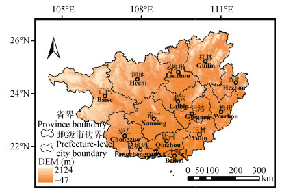
图1研究区概况图
Figure1.Overview of the research area
 下载: 全尺寸图片幻灯片
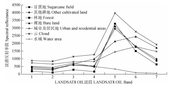
图22018年广西各典型地物LANDSAT8波谱特征曲线图
Figure2.Spectral characteristics curves of LANDSAT8 of various typical surface features in Guangxi in 2018
下载: 全尺寸图片幻灯片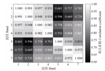
图3LANDSAT 8 OLI各波段间相关系数热力图
Figure3.LANDSAT 8 OLI correlation coefficient thermal map of each band
下载: 全尺寸图片幻灯片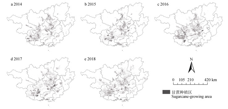
图42014—2018年广西区甘蔗种植区空间分布图
Figure4.Spatial distribution maps of sugarcane planting areas in Guangxi from 2014 to 2018
下载: 全尺寸图片幻灯片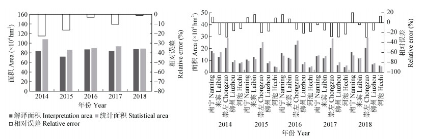
图52014—2018年广西(a)及其主要甘蔗种植区(b)的统计年鉴精度评价图
Figure5.Accuracy evaluation charts of a statistical yearbook of entire region (a) and major sugarcane planting areas (b) of Guangxi from 2014 to 2018
下载: 全尺寸图片幻灯片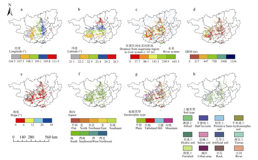
图62016年广西甘蔗种植面积分布的下垫面影响因素特征
Figure6.Spatial distribution characteristics of influencing factors of sugarcane planting area distribution in Guangxi in 2016
下载: 全尺寸图片幻灯片
图72014—2018年广西区甘蔗茎伸期(8—9月)长势空间分布特征
Figure7.Spatial distribution of growth vigour of sugarcane stem extension period (August to September) in Guangxi from 2014 to 2018
下载: 全尺寸图片幻灯片表1广西甘蔗长势的NDVI差值等级划分
Table1.NDVI difference classification of sugarcane growth in Guangxi
| NDVI | (?∞, ?0.3] | (?0.3, ?0.1] | (?0.1, 0.1] | (0.1, 0.3] | (0.3, +∞) | |
| 长势等级 Growth grade | 较常年差 Poor growth than usual | 较常年稍差 Poor growth slightly than usual | 与常年持平 The growth is the same as usual | 较常年稍好 Good growth slightly than usual | 较常年好 Good growth than usual | |
| 甘蔗长势等级 Sugarcane growth grade | 长势差 Poor growth | 长势正常 Normal growth | 长势好 Good growth | |||
下载: 导出CSV表2广西典型地物解译标志(包含云)
Table2.Interpretation signs of the typical features in Guangxi (including clouds)
| 典型地物类型 Typical feature type | 谷歌地球影像 Google earth image | 波段组合(4-3-2) Band combination (4-3-2) | 波段组合(6-5-2) Band combination (6-5-2) | 解译特征 Interpret characteristics |
| 甘蔗地 Sugarcane field |  |  |  | 在4-3-2波段组合中主要呈深绿色, 色调均匀; 在6-5-2波段组合中呈淡绿色, 色调均匀, 偏暗, 纹理比较规则, 大部分在空间上呈大片种植。 It is mainly dark green in band combination 4-3-2 with uniform tone. In band combination 6-5-2, it is light green with uniform tone and dark color. The texture is relatively regular. Most of them are planted in large areas in space. |
| 其他耕地 Other cultivated land |  |  |  | 在4-3-2波段组合中呈淡绿色, 较甘蔗亮; 在6-5-2波段组合中呈黄绿色夹杂着暗紫色, 色调较甘蔗暗, 纹理粗糙, 与甘蔗交叉镶嵌。 In band combination 4-3-2, it is light green and brighter than sugarcane. In band combination 6-5-2, it is yellow-green mixed with dark purple, darker than sugarcane, with rough texture and cross mosaic with sugarcane. |
| 林地 Forest |  |  |  | 在4-3-2波段组合中呈墨绿色; 6-5-2波段组合中呈淡青色; 纹理特征较粗糙, 呈不规则块状。 It is dark green in band combination 4-3-2. In band combination 6-5-2, the color is light blue. Texture is rough, irregular block. |
| 城市及居民地 Urban and residential areas |  |  |  | 在4-3-2波段组合中呈褐色、浅蓝色或白色; 在6-5-2波段组合中呈紫色或淡紫色; 纹理粗糙, 呈规则块状。 It is brown, light blue or white in band combination 4-3-2, and purple or mauve in band combination 6-5-2. The texture is rough and regular blocks. |
| 裸地Bare land |  |  |  | 在4-3-2波段组合中呈棕红色; 在6-5-2波段组合中呈淡紫色, 纹理粗糙, 呈不规则块状。 It is brownish red in band combination 4-3-2, and lavender in color in band combination 6-5-2. The texture is rough and irregular lumps. |
 |  |  | 在4-3-2波段组合中呈棕黄色; 在6-5-2波段组合中呈淡紫色偏黄; 纹理粗糙, 呈不规则块状。 It is brownish yellow in band combination 4-3-2, mauve and yellowish in band combination 6-5-2. The texture is rough and irregular. | |
| 水域 Water area |  |  |  | 在4-3-2波段组合中呈淡蓝色; 在6-5-2波段组合中呈深蓝色; 主要呈不规则块状或带状, 纹理细腻。 It is light blue in band combination 4-3-2, dark blue in band combination 6-5-2. The texture is fine mainly with irregular block or ribbon. |
| 云 Cloud | —— |  |  | 4-3-2波段组合和6-5-2波段组合中均呈纯白色, 其中少部分呈淡灰色, 云量密集纹理细腻, 稀少则相对粗糙, 多为块状。 It is pure white both in bond combination 4-3-2 and 6-5-2, with a small part of them being light gray. For the dense cloud cover, texture is fine; while for the rare ones, texture is relatively rough and mostly lumpy. |
下载: 导出CSV表32014—2018年广西地物混淆矩阵分类精度表
Table3.Confusion matrix classification accuracy table of surface features in Guangxi from 2014 to 2018
| 分类年份 Classification year | 总体精度 Overall accuracy (%) | Kappa系数Kappa coefficient | 用户精度User accuracy (%) | 生产者精度Producer accuracy (%) | ||||
| 甘蔗地Sugarcane field | 其他地物Other features | 甘蔗地Sugarcane field | 其他地物Other features | |||||
| 2014 | 96.88 | 0.9567 | 87.19 | 99.47 | 88.89 | 99.38 | ||
| 2015 | 98.91 | 0.9560 | 88.06 | 99.74 | 87.05 | 99.76 | ||
| 2016 | 98.58 | 0.9772 | 93.79 | 99.25 | 85.33 | 99.72 | ||
| 2017 | 92.44 | 0.8564 | 80.35 | 99.97 | 98.45 | 99.61 | ||
| 2018 | 95.57 | 0.9422 | 89.92 | 99.80 | 98.90 | 98.06 | ||
下载: 导出CSV参考文献
| [1] | HARIHARAN S, MANDAL D, TIRODKAR S, et al. A novel phenology based feature subset selection technique using random forest for multitemporal PolSAR crop classification[J]. IEEE Journal of Selected Topics in Applied Earth Observations and Remote Sensing, 2018, 11(11): 4244-4258 doi: 10.1109/JSTARS.2018.2866407 |
| [2] | 李正国, 唐华俊, 杨鹏, 等. 植被物候特征的遥感提取与农业应用综述[J]. 中国农业资源与区划, 2012, 33(5): 20-28 https://www.cnki.com.cn/Article/CJFDTOTAL-ZGNZ201205004.htm LI Z G, TANG H J, YANG P, et al. Progress in remote sensing of vegetation phenology and its application in agriculture[J]. Chinese Journal of Agricultural Resources and Regional Planning, 2012, 33(5): 20-28 https://www.cnki.com.cn/Article/CJFDTOTAL-ZGNZ201205004.htm |
| [3] | YOUNG L J. Agricultural crop forecasting for large geographical areas[J]. Annual Review of Statistics and Its Application, 2019, 6: 173-196 doi: 10.1146/annurev-statistics-030718-105002 |
| [4] | 郝鹏宇, 唐华俊, 陈仲新, 等. 基于历史增强型植被指数时序的农作物类型早期识别[J]. 农业工程学报, 2018, 34(13): 179-186 doi: 10.11975/j.issn.1002-6819.2018.13.021 HAO P Y, TANG H J, CHEN Z X, et al. Early season crop type recognition based on historical EVI time series[J]. Transactions of the Chinese Society of Agricultural Engineering, 2018, 34(13): 179-186 doi: 10.11975/j.issn.1002-6819.2018.13.021 |
| [5] | 史舟, 梁宗正, 杨媛媛, 等. 农业遥感研究现状与展望[J]. 农业机械学报, 2015, 46(2): 247-260 https://www.cnki.com.cn/Article/CJFDTOTAL-NYJX201502037.htm SHI Z, LIANG Z Z, YANG Y Y, et al. Status and prospect of agricultural remote sensing[J]. Transactions of the Chinese Society for Agricultural Machinery, 2015, 46(2): 247-260 https://www.cnki.com.cn/Article/CJFDTOTAL-NYJX201502037.htm |
| [6] | JIANG T, LIU X N, WU L. Method for mapping rice fields in complex landscape areas based on pre-trained convolutional neural network from HJ-1 A/B data[J]. ISPRS International Journal of Geo-Information, 2018, 7(11): 418 doi: 10.3390/ijgi7110418 |
| [7] | 黄健熙, 黄海, 马鸿元, 等. 遥感与作物生长模型数据同化应用综述[J]. 农业工程学报, 2018, 34(21): 144-156 doi: 10.11975/j.issn.1002-6819.2018.21.018 HUANG J X, HUANG H, MA H Y, et al. Review on data assimilation of remote sensing and crop growth models[J]. Transactions of the Chinese Society of Agricultural Engineering, 2018, 34(21): 144-156 doi: 10.11975/j.issn.1002-6819.2018.21.018 |
| [8] | AGHIGHI H, AZADBAKHT M, ASHOURLOO D, et al. Machine learning regression techniques for the silage maize yield prediction using time-series images of landsat 8 OLI[J]. IEEE Journal of Selected Topics in Applied Earth Observations and Remote Sensing, 2018, 11(12): 4563-4577 doi: 10.1109/JSTARS.2018.2823361 |
| [9] | 刘佳, 王利民, 杨福刚, 等. 基于HJ时间序列数据的农作物种植面积估算[J]. 农业工程学报, 2015, 31(3): 199-206 doi: 10.3969/j.issn.1002-6819.2015.03.026 LIU J, WANG L M, YANG F G, et al. Remote sensing estimation of crop planting area based on HJ time-series images[J]. Transactions of the Chinese Society of Agricultural Engineering, 2015, 31(3): 199-206 doi: 10.3969/j.issn.1002-6819.2015.03.026 |
| [10] | 黄健熙, 贾世灵, 武洪峰, 等. 基于GF-1 WFV影像的作物面积提取方法研究[J]. 农业机械学报, 2015, 46(S1): 253-259 doi: 10.6041/j.issn.1000-1298.2015.S0.041 HUANG J X, JIA S L, WU H F, et al. Extraction method of crop planted area based on GF-1 WFV image[J]. Transactions of the Chinese Society for Agricultural Machinery, 2015, 46(S1): 253-259 doi: 10.6041/j.issn.1000-1298.2015.S0.041 |
| [11] | WANG B, LI J, JIN X F, et al. Mapping tea plantations from multi-seasonal landsat-8 OLI imageries using a random forest classifier[J]. Journal of the Indian Society of Remote Sensing, 2019, 47(8): 1315-1329 doi: 10.1007/s12524-019-01014-5 |
| [12] | 苏伟, 朱德海, 苏鸣宇, 等. 基于时序LAI的地块尺度玉米长势监测方法[J]. 资源科学, 2019, 41(3): 601-611 https://www.cnki.com.cn/Article/CJFDTOTAL-ZRZY201903018.htm SU W, ZHU D H, SU M Y, et al. Field-scale corn growth monitoring using time series LAI[J]. Resources Science, 2019, 41(3): 601-611 https://www.cnki.com.cn/Article/CJFDTOTAL-ZRZY201903018.htm |
| [13] | 陶惠林, 徐良骥, 冯海宽, 等. 基于无人机高光谱长势指标的冬小麦长势监测[J]. 农业机械学报, 2020, 51(2): 180-191 https://www.cnki.com.cn/Article/CJFDTOTAL-NYJX202002020.htm TAO H L, XU L J, FENG H K, et al. Monitoring of winter wheat growth based on UAV hyperspectral growth index[J]. Transactions of the Chinese Society for Agricultural Machinery, 2020, 51(2): 180-191 https://www.cnki.com.cn/Article/CJFDTOTAL-NYJX202002020.htm |
| [14] | CHEN Y L, FENG L P, MO J F, et al. Identification of sugarcane with NDVI time series based on HJ-1 CCD and MODIS fusion[J]. Journal of the Indian Society of Remote Sensing, 2020, 48(2): 249-262 doi: 10.1007/s12524-019-01042-1 |
| [15] | LU D, WENG Q. A survey of image classification methods and techniques for improving classification performance[J]. International Journal of Remote Sensing, 2007, 28(5/6): 823-870 http://icesjms.oxfordjournals.org/external-ref?access_num=10.1080/01431160600746456&link_type=DOI |
| [16] | 刘佳, 王利民, 姚保民, 等. 基于多时相OLI数据的宁夏大尺度水稻面积遥感估算[J]. 农业工程学报, 2017, 33(15): 200-209 doi: 10.11975/j.issn.1002-6819.2017.15.026 LIU J, WANG L M, YAO B M, et al. Ningxia rice area remote sensing estimation on large scale based on multi-temporal OLI data[J]. Transactions of the Chinese Society of Agricultural Engineering, 2017, 33(15): 200-209 doi: 10.11975/j.issn.1002-6819.2017.15.026 |
| [17] | 董秀春, 黄平, 李宗南, 等. 基于遥感影像的云南甘蔗种植区优势评估[J]. 中国农学通报, 2020, 36(15): 160-163 https://www.cnki.com.cn/Article/CJFDTOTAL-ZNTB202015026.htm DONG X C, HUANG P, LI Z N, et al. Evaluation of comparative advantage of sugarcane planting area in Yunnan based on remote sensing images[J]. Chinese Agricultural Science Bulletin, 2020, 36(15): 160-163 https://www.cnki.com.cn/Article/CJFDTOTAL-ZNTB202015026.htm |
| [18] | LUCIANO A C D S, PICOLI M C A, ROCHA J V, et al. A generalized space-time OBIA classification scheme to map sugarcane areas at regional scale, using Landsat images time-series and the random forest algorithm[J]. International Journal of Applied Earth Observation and Geoinformation, 2019, 80: 127-136 doi: 10.1016/j.jag.2019.04.013 |
| [19] | GUMMA M K, THENKABAIL P S, TELUGUNTLA P G, et al. Agricultural cropland extent and areas of South Asia derived using Landsat satellite 30-m time-series big-data using random forest machine learning algorithms on the Google Earth Engine cloud[J]. GIScience & Remote Sensing, 2020, 57(3): 302-322 |
| [20] | DUVEILLER G, LOPEZ-LOZANO R, BARUTH B. Enhanced processing of 1-km spatial resolution fapar time series for sugarcane yield forecasting and monitoring[J]. Remote Sensing, 2013, 5(3): 1091-1116 doi: 10.3390/rs5031091 |
| [21] | BECKER-RESHEF I, VERMOTE E, LINDEMAN M, et al. A generalized regression-based model for forecasting winter wheat yields in Kansas and Ukraine using MODIS data[J]. Remote Sensing of Environment, 2010, 114(6): 1312-1323 doi: 10.1016/j.rse.2010.01.010 |
| [22] | GENOVESE G, VIGNOLLES C, NèGRE T, et al. A methodology for a combined use of normalised difference vegetation index and CORINE land cover data for crop yield monitoring and forecasting. A case study on Spain[J]. Agronomie, EDP Sciences, 2001, 21(1): 90-111 http://agris.fao.org/openagris/search.do?recordID=FR2001002143 |
| [23] | 黄青, 周清波, 王利民, 等. 基于遥感的冬小麦长势等级与气象因子相关性分析[J]. 农业机械学报, 2014, 45(12): 301-307 doi: 10.6041/j.issn.1000-1298.2014.12.043 HUANG Q, ZHOU Q B, WANG L M, et al. Relationship between winter wheat growth grades obtained from remote-sensing and meteorological factor[J]. Transactions of the Chinese Society for Agricultural Machinery, 2014, 45(12): 301-307 doi: 10.6041/j.issn.1000-1298.2014.12.043 |
| [24] | 潘学鹏, 李改欣, 刘峰贵, 等. 华北平原冬小麦面积遥感提取及时空变化研究[J]. 中国生态农业学报, 2015, 23(4): 497-505 http://www.ecoagri.ac.cn/zgstny/ch/reader/view_abstract.aspx?file_no=2015414&flag=1 PAN X P, LI G X, LIU F G, et al. Using remote sensing to determine spatio-temporal variations in winter wheat growing area in the North China Plain[J]. Chinese Journal of Eco-Agriculture, 2015, 23(4): 497-505 http://www.ecoagri.ac.cn/zgstny/ch/reader/view_abstract.aspx?file_no=2015414&flag=1 |
| [25] | 王红营, 潘学鹏, 罗建美, 等. 基于遥感的华北平原农作物时空分布变化特征分析[J]. 中国生态农业学报, 2015, 23(9): 1199-1209 http://www.ecoagri.ac.cn/zgstny/ch/reader/view_abstract.aspx?file_no=2015915&flag=1 WANG H Y, PAN X P, LUO J M, et al. Using remote sensing to analyze spatiotemporal variations in crop planting in the North China Plain[J]. Chinese Journal of Eco-Agriculture, 2015, 23(9): 1199-1209 http://www.ecoagri.ac.cn/zgstny/ch/reader/view_abstract.aspx?file_no=2015915&flag=1 |
| [26] | 郭长强, 崔远来, 李新建, 等. 广西糖料甘蔗需水量和灌溉定额空间变异[J]. 农业工程学报, 2016, 32(8): 89-97 https://www.cnki.com.cn/Article/CJFDTOTAL-NYGU201608013.htm GUO C Q, CUI Y L, LI X J, et al. Spatial variation of sugarcane water requirement and irrigation quota in Guangxi[J]. Transactions of the Chinese Society of Agricultural Engineering, 2016, 32(8): 89-97 https://www.cnki.com.cn/Article/CJFDTOTAL-NYGU201608013.htm |
| [27] | 马尚杰, 裴志远, 汪庆发, 等. 基于多时相环境星数据的甘蔗收割过程遥感监测[J]. 农业工程学报, 2011, 27(3): 215-219 doi: 10.3969/j.issn.1002-6819.2011.03.041 MA S J, PEI Z Y, WANG Q F, et al. Research of sugarcane harvest process monitoring with multi-temporal HJ-1 satellite data[J]. Transactions of the CSAE, 2011, 27(3): 215-219 doi: 10.3969/j.issn.1002-6819.2011.03.041 |
| [28] | 丁美花, 谭宗琨, 李辉, 等. 基于HJ-1卫星数据的甘蔗种植面积调查方法探讨[J]. 中国农业气象, 2012, 33(2): 265-270 https://www.cnki.com.cn/Article/CJFDTOTAL-ZGNY201202019.htm DING M H, TAN Z K, LI H, et al. Survey methods of sugarcane plant area based on HJ-1 CCD data[J]. Chinese Journal of Agrometeorology, 2012, 33(2): 265-270 https://www.cnki.com.cn/Article/CJFDTOTAL-ZGNY201202019.htm |
| [29] | 覃泽林, 谢国雪, 李宇翔, 等. 多时相高分一号影像在丘陵地区大宗农作物提取中的应用[J]. 南方农业学报, 2017, 48(1): 181-188 https://www.cnki.com.cn/Article/CJFDTOTAL-GXNY201701030.htm QIN Z L, XIE G X, LI Y X, et al. Application of multi-temporal GF-1 image in extraction of staple crops in hilly region[J]. Journal of Southern Agriculture, 2017, 48(1): 181-188 https://www.cnki.com.cn/Article/CJFDTOTAL-GXNY201701030.htm |
| [30] | 潘莉莉. 基于高分二号遥感影像甘蔗种植区域面积提取[J]. 农业与技术, 2020, 40(14): 36-38 https://www.cnki.com.cn/Article/CJFDTOTAL-NYYS202014014.htm PAN L L. Extraction of sugarcane planting area based on GF-2 remote sensing image[J]. Agriculture & Technology, 2020, 40(14): 36-38 https://www.cnki.com.cn/Article/CJFDTOTAL-NYYS202014014.htm |
| [31] | 丁美花, 钟仕全, 谭宗琨, 等. MODIS与ETM数据在甘蔗长势遥感监测中的应用[J]. 中国农业气象, 2007, 28(2): 195-197 doi: 10.3969/j.issn.1000-6362.2007.02.020 DING M H, ZHONG S Q, TAN Z K, et al. Application of MODIS and ETM data in sugarcane growth monitoring[J]. Chinese Journal of Agrometeorology, 2007, 28(2): 195-197 doi: 10.3969/j.issn.1000-6362.2007.02.020 |
| [32] | 谭宗琨, 吴良林, 丁美花, 等. EOS/MODIS数据在广西甘蔗种植信息提取及面积估算的应用[J]. 气象, 2007, 33(11): 76-81 https://www.cnki.com.cn/Article/CJFDTOTAL-QXXX200711013.htm TAN Z K, WU L L, DING M H, et al. Study on the extraction of sugar-cane planting areas from EOS/MODIS data[J]. Meteorological Monthly, 2007, 33(11): 76-81 https://www.cnki.com.cn/Article/CJFDTOTAL-QXXX200711013.htm |
| [33] | 张东东, 周振, 宋晓东. 基于HJ卫星的中国南方地区甘蔗面积提取研究[J]. 中国农学通报, 2019, 35(16): 141-147 https://www.cnki.com.cn/Article/CJFDTOTAL-ZNTB201916022.htm ZHANG D D, ZHOU Z, SONG X D. Study on sugarcane crop classification in Southern China based on HJ-1 CCD images[J]. Chinese Agricultural Science Bulletin, 2019, 35(16): 141-147 https://www.cnki.com.cn/Article/CJFDTOTAL-ZNTB201916022.htm |
| [34] | BREIMAN L. Random forests, machine learning[J]. Journal of Clinical Microbiology, 2001, 2: 199-228 |
| [35] | VAN DER LINDEN S, RABE A, HELD M, et al. The EnMAP-Box-A toolbox and application programming interface for EnMAP data processing[J]. Remote Sensing, 2015, 7(9): 11249-11266 doi: 10.3390/rs70911249 |
| [36] | 黄青, 唐华俊, 周清波, 等. 东北地区主要作物种植结构遥感提取及长势监测[J]. 农业工程学报, 2010, 26(9): 218-223 doi: 10.3969/j.issn.1002-6819.2010.09.037 HUANG Q, TANG H J, ZHOU Q B, et al. Remote-sensing based monitoring of planting structure and growth condition of major crops in Northeast China[J]. Transactions of the CSAE, 2010, 26(9): 218-223 doi: 10.3969/j.issn.1002-6819.2010.09.037 |
| [37] | 权文婷, 周辉, 李红梅, 等. 基于S-G滤波的陕西关中地区冬小麦生育期遥感识别和长势监测[J]. 中国农业气象, 2015, 36(1): 93-99 doi: 10.3969/j.issn.1000-6362.2015.01.012 QUAN W T, ZHOU H, LI H M, et al. Remote recognition and growth monitoring of winter wheat in key stages based on S-G filter in Guanzhong Region[J]. Chinese Journal of Agrometeorology, 2015, 36(1): 93-99 doi: 10.3969/j.issn.1000-6362.2015.01.012 |
| [38] | 吴炳方, 张峰, 刘成林, 等. 农作物长势综合遥感监测方法[J]. 遥感学报, 2004, 8(6): 498-514 https://www.cnki.com.cn/Article/CJFDTOTAL-YGXB200406001.htm WU B F, ZHANG F, LIU C L, et al. An integrated method for crop condition monitoring[J]. Journal of Remote Sensing, 2004, 8(6): 498-514 https://www.cnki.com.cn/Article/CJFDTOTAL-YGXB200406001.htm |
| [39] | 陈晓宁, 吴满意, 温建兵, 等. 遥感解译标志建立思路研究[J]. 测绘与空间地理信息, 2017, 40(2): 35-37 doi: 10.3969/j.issn.1672-5867.2017.02.010 CHEN X N, WU M Y, WEN J B, et al. Research on the establishment of remote sensing interpretation marks[J]. Geomatics & Spatial Information Technology, 2017, 40(2): 35-37 doi: 10.3969/j.issn.1672-5867.2017.02.010 |
| [40] | 谢国雪, 黄文校, 卢远, 等. 基于高分辨率遥感影像的桑树信息提取研究——以广西鹿寨县为例[J]. 中国农业资源与区划, 2015, 36(2): 44-53 https://www.cnki.com.cn/Article/CJFDTOTAL-ZGNZ201502008.htm XIE G X, HUANG W X, LU Y, et al. Information extraction of silkworm-cropping areas based onhigh spatial resolution remote sensing images—A case study of Luzhai County, Guangxi, China[J]. Chinese Journal of Agricultural Resources and Regional Planning, 2015, 36(2): 44-53 https://www.cnki.com.cn/Article/CJFDTOTAL-ZGNZ201502008.htm |
| [41] | 赖格英, 杨星卫. 南方丘陵地区水稻种植面积遥感信息提取的试验[J]. 应用气象学报, 2000, 11(1): 47-54 doi: 10.3969/j.issn.1001-7313.2000.01.006 LAI G Y, YANG X W. Experimental research on rice planting area of hilly region in southern China using remotely sensed data[J]. Quarterly Journal of Applied Meteorology, 2000, 11(1): 47-54 doi: 10.3969/j.issn.1001-7313.2000.01.006 |
| [42] | 陈刘凤, 林开平, 胡宝清, 等. 基于Landsat8_OLI数据的甘蔗种植面积监测[J]. 南方农业学报, 2015, 46(11): 2068-2072 doi: 10.3969/j:issn.2095-1191.2015.11.2068 CHEN L F, LIN K P, HU B Q, et al. Monitoring of sugarcane planting area based on Landsat8_OLI data[J]. Journal of Southern Agriculture, 2015, 46(11): 2068-2072 doi: 10.3969/j:issn.2095-1191.2015.11.2068 |
| [43] | 钟仕全. 遥感数据助力"一带一路"重要门户——广西经济发展[J]. 卫星应用, 2016, (10): 42-47 https://www.cnki.com.cn/Article/CJFDTOTAL-WXYG201610013.htm ZHONG S Q. Remote sensing data contributes to the important portal of "One Belt And One Road"—Guangxi economic development[J]. Satellite Application, 2016, (10): 42-47 https://www.cnki.com.cn/Article/CJFDTOTAL-WXYG201610013.htm |
| [44] | 黄干淇, 王国安, 黄子航, 等. 基于GF-1的上思县甘蔗种植面积估算与长势监测研究[J]. 气象研究与应用, 2018, 39(3): 53-56 https://www.cnki.com.cn/Article/CJFDTOTAL-GXQX201803013.htm HUANG G Q, WANG G A, HUANG Z H, et al. The study of estimation and growth monitoring of sugarcane planting area in Shangsi County based on GF-1[J]. Journal of Meteorological Research and Application, 2018, 39(3): 53-56 https://www.cnki.com.cn/Article/CJFDTOTAL-GXQX201803013.htm |
