徐飞飞1, 2,,,
罗明1, 2,
梁爽1, 2,
赵晨1, 2,
冯险峰1
1.中国科学院地理科学与资源研究所 北京 100101
2.中科禾信遥感科技(苏州)有限公司 苏州 215151
基金项目: 国家重点研发计划项目2016YFD0300201
苏州市科技计划项目SNG2018100
详细信息
作者简介:陆洲, 主要从事农业遥感应用研究。E-mail: luzhou@igsnrr.ac.cn
通讯作者:徐飞飞, 主要研究方向为农业遥感应用。E-mail: 1304659769@qq.com
中图分类号:S127计量
文章访问数:149
HTML全文浏览量:13
PDF下载量:98
被引次数:0
出版历程
收稿日期:2020-07-08
录用日期:2020-08-14
刊出日期:2021-04-01
Characteristic analysis of lodging rice and study of the multi-spectral remote sensing extraction method
LU Zhou1,,XU Feifei1, 2,,,
LUO Ming1, 2,
LIANG Shuang1, 2,
ZHAO Chen1, 2,
FENG Xianfeng1
1. Institute of Geographic Sciences and Natural Resources Research, Chinese Academy of Sciences, Beijing 100101, China
2. Crop-info Remote Sensing Technology(Suzhou) Co., Ltd., Suzhou 215151, China
Funds: the National Key R & D Program of China2016YFD0300201
Suzhou Science and Technology ProjectSNG2018100
More Information
Corresponding author:XU Feifei, E-mail: 1304659769@qq.com
摘要
HTML全文
图
参考文献
相关文章
施引文献
资源附件
访问统计
摘要
摘要:倒伏水稻的识别对灾后农业生产管理、灾害保险、补贴等工作有重要意义。为应用高分辨率遥感影像准确提取倒伏水稻面积,本文利用2019年9月27日获取的哨兵2号多光谱遥感影像,研究黑龙江省同江市倒伏水稻的光谱、纹理特征,并基于光谱与纹理特征建立倒伏水稻的遥感提取模型。研究结果表明水稻倒伏后可见光-近红外-短波红外等8个波段的反射率均升高,其中短波红外、红光和红边1等3个波段的反射率上升大于0.06。倒伏水稻的典型植被指数中,归一化植被指数、比值植被指数、增强植被指数和红边位置指数均降低,但差值植被指数升高。倒伏与正常水稻在红光、红边1和短波红外等3个波段的均值纹理数值差距明显,红光波段的纹理均值差异最大。利用归一化植被指数、地表水分指数、比值植被指数和差值植被指数以及红光波段的纹理均值构建决策树分类模型,监测结果表明农场内倒伏水稻分布较散,其西部和南部水稻受灾面积较大,北部受灾面积较小,中部偏北和东部基本未倒伏。将本文模型所提取的结果与实测面积对比,正常与倒伏水稻的面积识别误差分别为3.33%和2.23%。利用随机验证样本与模型验证结果进行混淆矩阵分析,倒伏水稻的用户精度和制图精度均为92.0%,Kappa系数为0.93。该方法能够适用于大区域倒伏水稻提取,可为高分辨率多光谱遥感数据调查水稻倒伏面积提供相关依据。
关键词:哨兵2号影像/
倒伏水稻/
光谱特征/
纹理特征/
遥感提取
Abstract:Crop lodging assessment is essential for evaluating yield damage and informing crop management decisions for sustainable agricultural production. Traditional evaluation methods and manual on-site measurements are time-consuming and labor- and capital-intensive. In this study, a remote sensing model to distinguish lodging rice was constructed based on spectral and textural features. To accurately extract the area of lodging rice from high-resolution remote sensing images, this study used Sentinel-2 multispectral images taken on September 27, 2019, to study the spectral and textural characteristics of lodging rice, in Tongjiang City, Heilongjiang Province. Analysis of the surface reflectance of normal rice and lodged rice, showed that reflectance of eight bands, including visible light, near-infrared, and shortwave infrared, increased after rice lodging; the reflectance of shortwave infrared, red light, and red edge 1 increased by more than 0.06. Except for the difference vegetation index (DVI), the typical vegetation indices of lodged rice, such as normalized difference vegetation index (NDVI), ratio vegetation index (RVI), enhanced vegetation index (EVI), and red edge position index (REP), decreased. There were significant differences between lodging rice and normal rice in the mean texture feature values of the red band, red edge 1, and shortwave infrared; the largest difference was for the mean texture value of the red band. Therefore, in this study, normalized difference vegetation index, land surface water index (LSWI), ratio vegetation index, difference vegetation index, and texture mean of the red band were used to construct the decision tree classification model. The results of remote sensing monitoring showed that rice lodging on the farm was decentralized. The area of rice disaster was larger in the west and south and smaller in the north. There was no lodging rice in the middle of the north and the east. Compared with the measured area, the area recognition errors of normal and lodged rice were 3.33% and 2.23%, respectively. When using random verification samples and model verification results for the confusion matrix analysis, the user accuracy and mapping accuracy of lodging rice were 92.0%, and the Kappa coefficient was 0.93. These results show that this method can be applied to remote sensing data from lodged rice in large areas and can provide a relevant basis for the investigation of rice lodging areas using high-resolution and multi-spectral remote sensing data.
Key words:Sentinel-2 image/
Lodging rice/
Spectral characteristics/
Texture features/
Remote sensing extraction
HTML全文
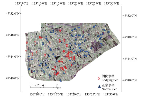
图1倒伏水稻和正常水稻的样本点分布
Figure1.Distribution of lodging rice and normal rice sample points
 下载: 全尺寸图片幻灯片
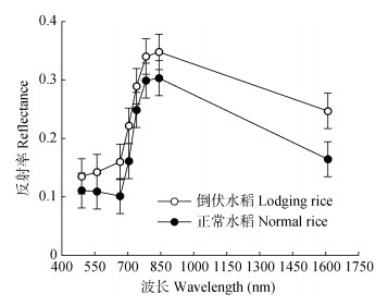
图2倒伏水稻和正常水稻的多光谱曲线
Figure2.Spectral curves of lodging rice and normal rice
下载: 全尺寸图片幻灯片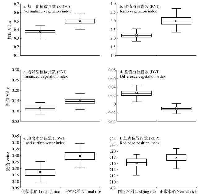
图3正常水稻与倒伏水稻的各光谱指数
Figure3.Spectral indexes of normal rice and lodging rice
下载: 全尺寸图片幻灯片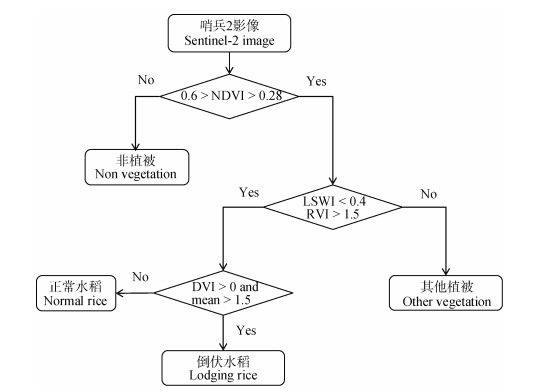
图4倒伏水稻遥感识别技术流程图
图中各缩写说明见表 2。
Figure4.Flow chart of remote sensing identification technology for lodging rice
The meanings of abbreviations are shown in the table 2.
下载: 全尺寸图片幻灯片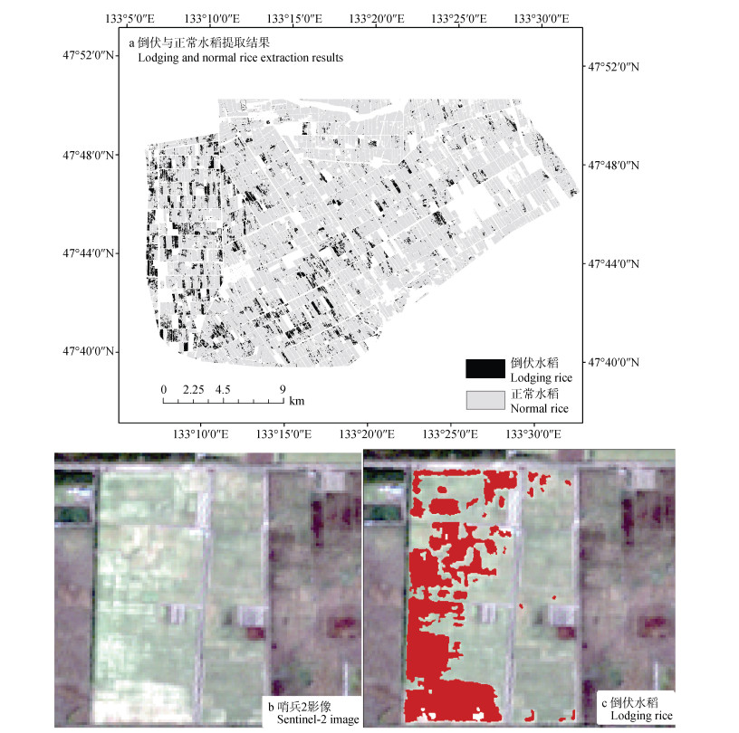
图5研究区正常水稻与倒伏水稻遥感识别结果
Figure5.Remote sensing recognition results of normal rice and lodging rice in the study area
下载: 全尺寸图片幻灯片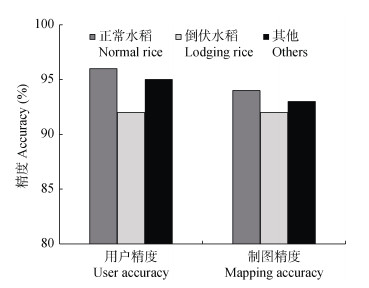
图6研究区倒伏水稻和正常水稻的用户精度与制图精度
Figure6.User accuracy and mapping accuracy of lodging rice and normal rice in the study area
下载: 全尺寸图片幻灯片表1本文选用的哨兵2号影像波段及分辨率
Table1.Sentinel-2 image bands and resolution used in this study
| 波段 Sentinel-2 band | 中心波长 Central wavelength (μm) | 分辨率 Resolution (m) |
| 蓝光?Band 2-blue | 0.490 | 10 |
| 绿光?Band 3-green | 0.560 | 10 |
| 红光?Band 4-red | 0.665 | 10 |
| 红边1 Band 5-red edge 1 | 0.705 | 20 |
| 红边2 Band 6-red edge 2 | 0.740 | 20 |
| 红边3 Band 7-red edge 3 | 0.783 | 20 |
| 近红外?Band 8-near infrared | 0.842 | 10 |
| 短波红外 Band 11-short wave infrared | 1.610 | 20 |
下载: 导出CSV表2本文选用的各光谱指数的计算公式
Table2.Calculation formulas of each spectral index used in this study
| 光谱指数 Spectral index | 简写 Abbreviation | 计算公式 Formula | 文献 Reference |
| 归一化植被指数 Normalized difference vegetation index | NDVI | $\frac{{{\rho _{{\rm{nir}}}} - {\rho _{{\rm{red}}}}}}{{{\rho _{{\rm{nir}}}} + {\rho _{{\rm{red}}}}}}$ | [30] |
| 比值植被指数 Ratio vegetation index | RVI | ${\rho _{{\rm{nir}}}}/{\rho _{{\rm{red}}}}$ | [34] |
| 差值植被指数 Difference vegetation index | DVI | ${\rho _{{\rm{red}}}} - {\rho _{{\rm{blue}}}}$ | [35] |
| 地表水分指数 Land surface water index | LSWI | $\frac{{{\rho _{{\rm{nir}}}} - {\rho _{{\rm{swir}}}}}}{{{\rho _{{\rm{nir}}}} + {\rho _{{\rm{swir}}}}}}$ | [36] |
| 增强型植被指数 Enhanced vegetation index | EVI | $\frac{{2.5 \times \left( {{\rho _{{\rm{nir}}}} - {\rho _{{\rm{red}}}}} \right)}}{{{\rho _{{\rm{nir}}}} + 6{\rho _{{\rm{red}}}} - 7.5{\rho _{{\rm{blue}}}} + 1}}$ | [37] |
| 红边位置指数 Red edge position index | REP | $\frac{{\left( {{\rho _{670}} + {\rho _{780}}} \right)/2 - {\rho _{700}}}}{{{\rho _{740}} - {\rho _{700}}}} \times 40 + 700$ | [32-33] |
| ρblue、ρgreen、ρred和ρnir分别为蓝光、绿光、红光和近红外波段反射率。ρ60、ρ700、ρ740和ρ780表示为在波长670 nm、700 nm、740 nm和780 nm处的反射率。700与40是700~740 nm区间进行内插产生的常数。ρblue, ρgreen, ρred and ρnir is blue, green, red and near-infrared reflectance. ρ670, ρ700, ρ740 and ρ780 is the reflectivity at the wavelength of 670 nm, 700 nm, 740 nm and 780 nm. 700 and 40 are constants produced by interpolation in the range of 700-740 nm. | |||
下载: 导出CSV表3正常水稻与倒伏水稻各波段均值纹理
Table3.Mean texture of normal rice and lodging rice
| 波段 Band | 倒伏水稻?Lodging rice | 正常水稻?Normal rice | 相对差异 Relative difference (%) | |||||
| 均值 Mean | 方差 Variance | 差异系数 Difference coefficient (%) | 均值 Mean | 方差 Variance | 差异系数 Difference coefficient (%) | |||
| 蓝光?Blue | 2.03 | 0.09 | 4.37 | 2.00 | 0.07 | 3.50 | 1.48 | |
| 绿光?Green | 2.47 | 0.38 | 15.26 | 2.00 | 0.09 | 4.50 | 18.96 | |
| 红光?Red | 2.00 | 0.11 | 5.62 | 1.11 | 0.25 | 22.92 | 44.34 | |
| 红边1 Red edge 1 | 4.77 | 0.45 | 9.45 | 3.53 | 0.43 | 12.18 | 25.87 | |
| 红边2 Red edge 2 | 7.73 | 0.62 | 8.01 | 6.78 | 0.40 | 5.87 | 12.21 | |
| 红边3 Red edge 3 | 8.52 | 0.66 | 7.74 | 7.72 | 0.43 | 5.61 | 9.34 | |
| 近红外?Near infrared | 8.30 | 0.59 | 7.09 | 7.44 | 0.45 | 6.11 | 10.34 | |
| 短波红外?Short wave infrared | 6.28 | 0.51 | 8.09 | 4.92 | 0.28 | 5.64 | 21.67 | |
| 差异系数=方差/均值×100%; 相对差异=(倒伏水稻均值-正常水稻均值)/倒伏水稻均值×100%。Difference coefficient = variance/mean×100%, relative difference = (mean value of lodging rice-mean value of normal rice) / mean value of lodging rice×100%. | ||||||||
下载: 导出CSV表4研究区倒伏与正常水稻遥感识别面积与统计面积对比
Table4.Comparison of recognition area by remote sensing and statistical area of lodging and normal rice in the study area
| 类型 Type | 遥感提取面积Remote sensing extraction area (km2) | 实测面积 Measured area (km2) | 识别误差 Recognition error (%) |
| 正常水稻 Normal rice | 344.33 | 356.20 | -3.33 |
| 倒伏水稻 Lodging rice | 33.87 | 33.13 | 2.23 |
| 合计?Total | 378.20 | 389.33 | -2.86 |
下载: 导出CSV参考文献
| [1] | 饶玉春, 李跃, 董国军, 等. 水稻抗倒伏研究进展[J]. 中国稻米, 2009, (6): 15-19 doi: 10.3969/j.issn.1006-8082.2009.06.004 RAO Y C, LI Y, DONG G J, et al. Research progress of rice antilodging[J]. China Rice, 2009, (6): 15-19 doi: 10.3969/j.issn.1006-8082.2009.06.004 |
| [2] | LANG Y Z, YANG X D, WANG M E, et al. Effects of lodging at different filling stages on rice yield and grain quality[J]. Rice Science, 2012, 19(4): 315-319 doi: 10.1016/S1672-6308(12)60056-0 |
| [3] | 刘利华, 金再欣, 刘小丽, 等. 水稻倒伏对产量影响的试验结果分析[J]. 中国稻米, 2009, (2): 19-21 doi: 10.3969/j.issn.1006-8082.2009.02.006 LIU L H, JIN Z X, LIU X L, et al. Influence trial of lodging on rice yield[J]. China Rice, 2009, (2): 19-21 doi: 10.3969/j.issn.1006-8082.2009.02.006 |
| [4] | 李宗南, 陈仲新, 王利民, 等. 基于小型无人机遥感的玉米倒伏面积提取[J]. 农业工程学报, 2014, 30(19): 207-213 doi: 10.3969/j.issn.1002-6819.2014.19.025 LI Z N, CHEN Z X, WANG L M, et al. Area extraction of maize lodging based on remote sensing by small unmanned aerial vehicle[J]. Transactions of the Chinese Society of Agricultural Engineering, 2014, 30(19): 207-213 doi: 10.3969/j.issn.1002-6819.2014.19.025 |
| [5] | 王猛, 张杰, 梁守真, 等. 玉米倒伏后冠层光谱变化特征分析[J]. 安徽农业科学, 2014, 42(31): 11187-11188 doi: 10.3969/j.issn.0517-6611.2014.31.122 WANG M, ZHANG J, LIANG S Z, et al. Character analysis of the canopy spectral changes after corn lodging[J]. Journal of Anhui Agricultural Sciences, 2014, 42(31): 11187-11188 doi: 10.3969/j.issn.0517-6611.2014.31.122 |
| [6] | 王猛, 隋学艳, 梁守真, 等. 夏玉米倒伏模拟试验及遥感监测[J]. 测绘科学, 2017, 42(8): 137-141 https://www.cnki.com.cn/Article/CJFDTOTAL-CHKD201708025.htm WANG M, SUI X Y, LIANG S Z, et al. Simulation test and remote sensing monitoring of summer corn lodging[J]. Science of Surveying and Mapping, 2017, 42(8): 137-141 https://www.cnki.com.cn/Article/CJFDTOTAL-CHKD201708025.htm |
| [7] | 张杰. 冬小麦倒伏遥感监测研究[D]. 济南: 山东师范大学, 2011 ZHANG J. A study on the lodge of winter wheat by remote sensing monitor[D]. Jinan: Shandong Normal University, 2011 |
| [8] | 王立志, 顾晓鹤, 胡圣武, 等. 基于多时相HJ-1B CCD影像的玉米倒伏灾情遥感监测[J]. 中国农业科学, 2016, 49(21): 4120-4129 doi: 10.3864/j.issn.0578-1752.2016.21.006 WANG L Z, GU X H, HU S W, et al. Remote sensing monitoring of maize lodging disaster with multi-temporal HJ-1B CCD image[J]. Scientia Agricultura Sinica, 2016, 49(21): 4120-4129 doi: 10.3864/j.issn.0578-1752.2016.21.006 |
| [9] | 刘良云, 王纪华, 宋晓宇, 等. 小麦倒伏的光谱特征及遥感监测[J]. 遥感学报, 2005, 9(3): 323-327 https://www.cnki.com.cn/Article/CJFDTOTAL-YGXB200503014.htm LIU L Y, WANG J H, SONG X Y, et al. The canopy spectral features and remote sensing of wheat lodging[J]. Journal of Remote Sensing, 2005, 9(3): 323-327 https://www.cnki.com.cn/Article/CJFDTOTAL-YGXB200503014.htm |
| [10] | 韩东, 杨浩, 杨贵军, 等. 基于Sentinel-1雷达影像的玉米倒伏监测模型[J]. 农业工程学报, 2018, 34(3): 166-172 HAN D, YANG H, YANG G J, et al. Monitoring model of maize lodging based on Sentinel-1 radar image[J]. Transactions of the Chinese Society of Agricultural Engineering, 2018, 34(3): 166-172 |
| [11] | 杨浩, 杨贵军, 顾晓鹤, 等. 小麦倒伏的雷达极化特征及其遥感监测[J]. 农业工程学报, 2014, 30(7): 1-8 doi: 10.3969/j.issn.1002-6819.2014.07.001 YANG H, YANG G J, GU X H, et al. Radar polarimetric response features and remote sensing monitoring of wheat lodging[J]. Transactions of the Chinese Society of Agricultural Engineering, 2014, 30(7): 1-8 doi: 10.3969/j.issn.1002-6819.2014.07.001 |
| [12] | YANG H, CHEN E X, LI Z Y, et al. Wheat lodging monitoring using polarimetric index from RADARSAT-2 data[J]. International Journal of Applied Earth Observation and Geoinformation, 2015, 34: 157-166 doi: 10.1016/j.jag.2014.08.010 |
| [13] | 李宗南, 陈仲新, 任国业, 等. 基于Worldview-2影像的玉米倒伏面积估算[J]. 农业工程学报, 2016, 32(2): 1-5 https://www.cnki.com.cn/Article/CJFDTOTAL-NYGU201602001.htm LI Z N, CHEN Z X, REN G Y, et al. Estimation of maize lodging area based on Worldview-2 image[J]. Transactions of the Chinese Society of Agricultural Engineering, 2016, 32(2): 1-5 https://www.cnki.com.cn/Article/CJFDTOTAL-NYGU201602001.htm |
| [14] | 董锦绘, 杨小冬, 高林, 等. 基于无人机遥感影像的冬小麦倒伏面积信息提取[J]. 黑龙江农业科学, 2016, (10): 174-152 https://www.cnki.com.cn/Article/CJFDTOTAL-HLJN201610039.htm DONG J H, YANG X D, GAO L, et al. Information extraction of winter wheat lodging area based on UAV remote sensing image[J]. Heilongjiang Agricultural Sciences, 2016, (10): 174-152 https://www.cnki.com.cn/Article/CJFDTOTAL-HLJN201610039.htm |
| [15] | CHAUHAN S, DARVISHZADEH R, LU Y, et al. Wheat lodging assessment using multispectral UAV data[C]//International Archives of the Photogrammetry, Remote Sensing and Spatial Information Sciences. Enschede, The Netherlands: 2019, 13: 235-240 |
| [16] | ZHAO X, YUAN Y T, SONG M D, et al. Use of unmanned aerial vehicle imagery and deep learning unet to extract rice lodging[J]. Sensors (Basel), 2019, 19(18): 3859 doi: 10.3390/s19183859 |
| [17] | 郑二功, 田迎芳, 陈涛, 等. 基于深度学习的无人机影像玉米倒伏区域提取[J]. 河南农业科学, 2018, 47(8): 155-160 https://www.cnki.com.cn/Article/CJFDTOTAL-HNNY201808026.htm ZHENG E G, TIAN Y F, CHEN T, et al. Region extraction of corn lodging in UAV images based on deep learning[J]. Journal of Henan Agricultural Sciences, 2018, 47(8): 155-160 https://www.cnki.com.cn/Article/CJFDTOTAL-HNNY201808026.htm |
| [18] | CHAUHAN S, DARVISHZADEH R, LU Y, et al. Understanding wheat lodging using multi-temporal Sentinel-1 and Sentinel-2 data[J]. Remote Sensing of Environment, 2020, 243: 111804 doi: 10.1016/j.rse.2020.111804 |
| [19] | DRUSCH M, BELLO U D, CARLIER S, et al. Sentinel-2: ESA's optical high-resolution mission for GMES operational services[J]. Remote Sensing of Environment, 2012, 120: 25-36 doi: 10.1016/j.rse.2011.11.026 |
| [20] | BAILLARIN S J, MEYGRET A, DECHOZ C, et al. Sentinel-2 level 1 products and image processing performances[C]//2012 IEEE International Geoscience and Remote Sensing Symposium. Munich, Germany: IEEE, 2012. |
| [21] | 苏伟, 张明政, 蒋坤萍, 等. Sentinel-2卫星影像的大气校正方法[J]. 光学学报, 2018, 38(1): 314-323 https://www.cnki.com.cn/Article/CJFDTOTAL-GXXB201801041.htm SU W, ZHANG M Z, JIANG K P, et al. Atmospheric correction method for Sentinel-2 satellite images[J]. Acta Optica Sinica, 2018, 38(1): 314-323 https://www.cnki.com.cn/Article/CJFDTOTAL-GXXB201801041.htm |
| [22] | 刘佳, 王利民, 滕飞, 等. RapidEye卫星红边波段对农作物面积提取精度的影响[J]. 农业工程学报, 2016, 32(13): 140-148 https://www.cnki.com.cn/Article/CJFDTOTAL-NYGU201613020.htm LIU J, WANG L M, TENG F, et al. Impact of red-edge waveband of RapidEye satellite on estimation accuracy of crop planting area[J]. Transactions of the Chinese Society of Agricultural Engineering, 2016, 32(13): 140-148 https://www.cnki.com.cn/Article/CJFDTOTAL-NYGU201613020.htm |
| [23] | 郑长春, 王秀珍, 黄敬峰. 多时相MODIS影像的浙江省水稻种植面积信息提取方法研究[J]. 浙江大学学报: 农业与生命科学版, 2009, 35(1): 98-104 https://www.cnki.com.cn/Article/CJFDTOTAL-ZJNY200901016.htm ZHENG C C, WANG X Z, HUANG J F. Mapping paddy rice planting area in Zhejiang Province using multi-temporal MODIS images[J]. Journal of Zhejiang University: Agriculture & Life Sciences, 2009, 35(1): 98-104 https://www.cnki.com.cn/Article/CJFDTOTAL-ZJNY200901016.htm |
| [24] | 魏新彩. 基于HJ卫星影像的水稻种植面积遥感信息提取方法研究——以江汉平原地区为例[D]. 武汉: 湖北大学, 2013 WEI X C. Extraction of paddy rice planting area based on environmental satellite image-Taking Jianghan Plain area as example[D]. Wuhan: Hubei University, 2013 |
| [25] | BAILLARIN S J, MEYGRET A, DECHOZ C, et al. Sentinel-2 level 1 products and image processing performances[C]//2012 IEEE International Geoscience and Remote Sensing Symposium (IGARSS). Munich, Germany: IEEE, 2012 |
| [26] | FRIEDL M A, BRODLEY C E. Decision tree classification of land cover from remotely sensed data[J]. Remote Sensing of Environment, 1997, 61(3): 399-409 doi: 10.1016/S0034-4257(97)00049-7 |
| [27] | CONRAD C, COLDITZ R R, DECH S, et al. Temporal segmentation of MODIS time series for improving crop classification in Central Asian irrigation systems[J]. International Journal of Remote Sensing, 2011, 32(23): 8763-8778 doi: 10.1080/01431161.2010.550647 |
| [28] | 马丽, 徐新刚, 刘良云, 等. 基于多时相NDVI及特征波段的作物分类研究[J]. 遥感技术与应用, 2008, 23(5): 520-524 https://www.cnki.com.cn/Article/CJFDTOTAL-YGJS200805005.htm MA L, XU X G, LIU L Y, et al. Study on crops classification based on multi-temporal NDVI and characteristic bands[J]. Remote Sensing Technology and Application, 2008, 23(5): 520-524 https://www.cnki.com.cn/Article/CJFDTOTAL-YGJS200805005.htm |
| [29] | 赵佳佳, 冯美臣, 杨武德, 等. 倒伏胁迫下冬小麦冠层光谱及红边特征[J]. 山西农业科学, 2015, 43(6): 673-676 https://www.cnki.com.cn/Article/CJFDTOTAL-SXLX201506012.htm ZHAO J J, FENG M C, YANG W D, et al. Canopy spectral and red edge characteristics of winter wheat under lodging stress[J]. Journal of Shanxi Agricultural Science, 2015, 43(6): 673-676 https://www.cnki.com.cn/Article/CJFDTOTAL-SXLX201506012.htm |
| [30] | 胡琼, 吴文斌, 宋茜, 等. 农作物种植结构遥感提取研究进展[J]. 中国农业科学, 2015, 48(10): 1900-1914 https://www.cnki.com.cn/Article/CJFDTOTAL-ZNYK201510005.htm HU Q, WU W B, SONG Q, et al. Recent progresses in research of crop patterns mapping by using remote sensing[J]. Scientia Agricultura Sinica, 2015, 48(10): 1900-1914 https://www.cnki.com.cn/Article/CJFDTOTAL-ZNYK201510005.htm |
| [31] | 王利民, 刘佳, 杨福刚, 等. GF-1卫星多时相组合近红外数据水稻识别能力[J]. 农业工程学报, 2017, 33(23): 196-202 https://www.cnki.com.cn/Article/CJFDTOTAL-NYGU201723026.htm WANG L M, LIU J, YANG F G, et al. Rice recognition ability basing on GF-1 multi-temporal phases combined with near infrared data[J]. Transactions of the Chinese Society of Agricultural Engineering, 2017, 33(23): 196-202 https://www.cnki.com.cn/Article/CJFDTOTAL-NYGU201723026.htm |
| [32] | 邹红玉, 郑红平. 浅述植被"红边"效应及其定量分析方法[J]. 遥感信息, 2010, (4): 112-116 https://www.cnki.com.cn/Article/CJFDTOTAL-YGXX201004028.htm ZOU H Y, ZHENG H P. The effect and method of quantitative analysis of "Red Edge" of vegetation[J]. Remote Sensing Information, 2010, (4): 112-116 https://www.cnki.com.cn/Article/CJFDTOTAL-YGXX201004028.htm |
| [33] | 程高峰, 李秉柏, 李萍萍, 等. 作物红边位置算法评述[J]. 江苏农业科学, 2009, (2): 12-14 https://www.cnki.com.cn/Article/CJFDTOTAL-JSNY200902006.htm CHENG G F, LI B B, LI P P, et al. Revliew on the crop red edge position algorithms[J]. Jiangsu Agricultural Sciences, 2009, (2): 12-14 https://www.cnki.com.cn/Article/CJFDTOTAL-JSNY200902006.htm |
| [34] | KIMURA R, OKADA S, MIURA H, et al. Relationships among the leaf area index, moisture availability, and spectral reflectance in an upland rice field[J]. Agricultural Water Management, 2004, 69(2): 83-100 http://www.sciencedirect.com/science/article/pii/S0378377404001519 |
| [35] | 张国圣. 基于高光谱的水稻氮素诊断和产量估测模型[D]. 沈阳: 沈阳农业大学, 2017 ZHANG G S. Estimation model of rice leaf nitrogen conter and yield based on hyperspectral[D]. Shenyang: Shenyang Agricultural University, 2017 |
| [36] | 刘元亮, 李艳, 吴剑亮. 基于LSWI和NDVI时间序列的水田信息提取研究[J]. 地理与地理信息科学, 2015, 31(3): 32-37 https://www.cnki.com.cn/Article/CJFDTOTAL-DLGT201503007.htm LIU Y L, LI Y, WU J L. Study on extraction of paddy fields based on LSWI and time-series NDVI[J]. Geography and Geo-Information Science, 2015, 31(3): 32-37 https://www.cnki.com.cn/Article/CJFDTOTAL-DLGT201503007.htm |
| [37] | 郝鹏宇, 唐华俊, 陈仲新, 等. 基于历史增强型植被指数时序的农作物类型早期识别[J]. 农业工程学报, 2018, 34(13): 179-186 https://www.cnki.com.cn/Article/CJFDTOTAL-NYGU201813021.htm HAO P Y, TANG H J, CHEN Z X, et al. Early season crop type recognition based on historical EVI time series[J]. Transactions of the Chinese Society of Agricultural Engineering, 2018, 34(13): 179-186 https://www.cnki.com.cn/Article/CJFDTOTAL-NYGU201813021.htm |
