金辉虎2,,,
王晨丞1,
孙瑞悉1
1.成都信息工程大学资源环境学院 成都 610225
2.交通运输部天津水运工程科学研究所 天津 300456
基金项目: 国家自然科学基金项目41706196
四川省科技计划项目2018JY0484
四川省教育厅自然科学重点项目18ZA0103
详细信息
作者简介:王利花, 主要从事微波遥感、资源与环境遥感等方面的研究。E-mail:wanglh@cuit.edu.cn
通讯作者:金辉虎, 主要从事环境保护和环境评价方面的研究。E-mail:1816091996@qq.com
中图分类号:P23计量
文章访问数:499
HTML全文浏览量:5
PDF下载量:398
被引次数:0
出版历程
收稿日期:2019-04-10
录用日期:2019-05-27
刊出日期:2019-09-01
Backscattering characteristics and texture information analysis of typical crops based on synthetic aperture radar: A case study of Nong'an County, Jilin Province
WANG Lihua1,,JIN Huihu2,,,
WANG Chencheng1,
SUN Ruixi1
1. College of Resources and Environment, Chengdu University of Information Technology, Chengdu 610225, China
2. Tianjin Research Institute for Water Transport Engineering, Ministry of Transport, Tianjin 300456, China
Funds: the National Natural Science Foundation of China41706196
Sichuan Science and Technology Progra2018JY0484
the Natural Science Key Research Program of Education Department of Sichuan Province18ZA0103
More Information
Corresponding author:JIN Huihu, E-mail:1816091996@qq.com
摘要
HTML全文
图
参考文献
相关文章
施引文献
资源附件
访问统计
摘要
摘要:及时掌握农作物类型、时空分布和结构信息,是合理调整农业结构的重要科学依据。针对光学遥感依赖于太阳辐射,在农作物生长周期内常受制于云雾的影响而无法获取到光学遥感数据的问题,本文采用全天时全天候、不受云雾等天气影响的合成孔径雷达(synthetic aperture radar,SAR)影像,探讨典型农作物的后向散射特性和纹理特征,为采用合成孔径雷达影像实现高精度农作物大面积监测提供科学依据。以吉林省农安县为例,利用12景Sentinel-1B双极化SAR影像数据,经影像预处理和统计分析,研究不同极化的农作物后向散射特性和纹理信息。结果表明:3种作物(大豆、玉米、水稻1和水稻2)同极化(VV)的SAR后向散射系数在生长周期内均高于交叉极化(VH),农作物植株形态改变极化方式的能力为-25~-15 dB。3种作物在整个生长期内,后向散射系数呈现较大波动,各阶段后向散射特征差异明显。在生长初期,土壤对后向散射特征起主要作用,在SAR图像上表现为暗色调;随着作物生长,冠层散射叠加土壤散射作用占据主要位置,散射值随作物生长呈现逐渐增加的趋势,在SAR图像上表现为亮色调;拔节(分枝)后(7月10日后)作物的后向散射信号除冠层散射作用外,还主要受到土壤含水量及其与作物相互作用的影响,因此拔节后两种水稻后向散射系数下降幅度较大。水稻对雷达波的吸收强于玉米和大豆,整体上后向散射系数第2种水稻<第1种水稻<玉米<大豆,尤其在VH极化方式下表现更明显。对作物SAR纹理信息的研究表明纹理信息的均值、方差和协同性对于农作物的SAR识别更有效,最佳纹理信息为VH极化均值,有利于识别3种作物;VV极化方差和VV协同性有助于区分两种水稻;SAR影像识别作物的最佳时相为5月23日至7月10日。
关键词:合成孔径雷达(SAR)/
农作物/
后向散射特性/
纹理信息/
同极化/
交叉极化
Abstract:Agriculture is the foundation of the national economy. Clarifying crop type, spatial and temporal distribution, and planting structure is an important scientific basis for the rational adjustment of agricultural framework. Optical remote sensing relies on solar radiation and is often subject to the influence of clouds. Therefore, optical remote sensing images cannot be obtained during cloudy weather. Synthetic aperture radar (SAR) images are not affected by cloud and fog and can provide all-day, all-weather data. Therefore, the backscatter characteristics and texture information of typical crops can be analyzed by using SAR images, which may improve accuracy of large area monitoring of crops in all weather conditions. In this study, Nong'an County in Jilin Province was taken as the study area, and 12 Sentinel-1B SAR images with dual-polarization were pre-processed. Then the SAR backscattering characteristics and texture information of typical crops with dual polarization were analyzed. The results showed that the co-polarization (VV) SAR backscattering coefficients of three crops (soybean, corn, rice 1 and rice 2) were higher than the cross-polarization (VH) coefficients during the growth period, and the ability of crop plants to change the polarization mode was about -25 to -15 dB. Over the whole growth seasons of crops, the backscattering coefficients showed large fluctuations. The backscattering characteristics of each growth stage were different. During the early growth stage of three crops, the soil played a major role in determining the backscattering characteristics, and the roughness of soil was small. Therefore, the three crops on the SAR images were dark in color. With the growth of the crops, the backscattering from crops was mainly due to canopy scattering and soil scattering. The backscatter coefficient value increased with crop growth, which meant that the color of the crops changed to a relatively bright shade on the SAR image. When crops reached the jointing stage or branching stage (after July 10), in addition to canopy scattering, their backscattering signal was strongly affected by the soil water content and its interaction with respective crops. The soil water content of rice was high. Therefore, the backscattering coefficient of rice considerably decreased after the jointing stage. The absorption of radar waves by rice was stronger than those of corn and soybean, which meant that the backscattering coefficient of rice was smaller than the coefficients for corn and soybean, especially in the VH polarization SAR images. The crop SAR texture information analysis showed that the mean, variance, and homogeneity could accurately identify crops on SAR images. The best texture information was the mean of VH polarization. The variance and homogeneity of VV polarization could also accurately identify the two kinds of rice. The best recognition phase for the crops on SAR images was from May 23 to July 10.
Key words:Synthetic aperture radar (SAR)/
Crops/
Backscattering characteristics/
Texture information/
VV polarization/
VH polarization
HTML全文
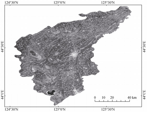
图12017年8月15日吉林省农安县的Sentinel-1B合成孔径雷达(SAR)影像
Figure1.Sentinel-1B synthetic aperture radar (SAR) image acquired on 15 August 2017 of Nong'an County in Jilin Province
 下载: 全尺寸图片幻灯片
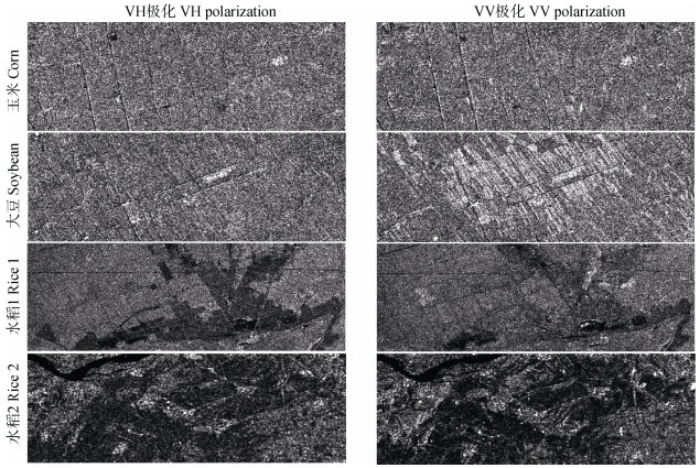
图22017年8月15日农安县典型农作物Sentinel-1B合成孔径雷达(SAR)不同极化方式的后向散射系数
Figure2.Backscattering coefficients of typical crops in Nong'an County under HV and VV polarizations of Sentinel-1B synthetic aperture radar (SAR) in on 15 August 2017
下载: 全尺寸图片幻灯片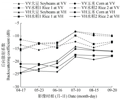
图3VV和VH极化方式下农作物后向散射系数随作物生长的变化规律
Figure3.Changes of synthetic aperture radar (SAR) backscattering coefficients under VV and VH polarizations of crops during growing season
下载: 全尺寸图片幻灯片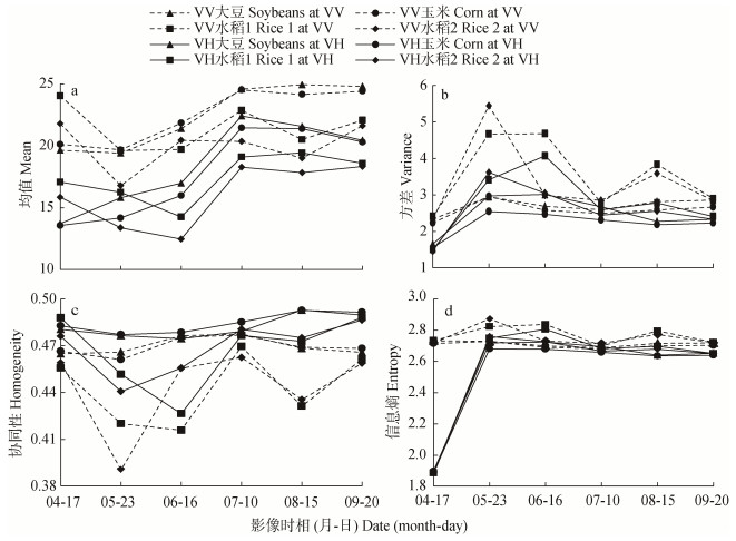
图4VV和VH极化方式下农作物纹理信息随作物生长变化规律
Figure4.Change of synthetic aperture radar (SAR) texture information of crops during growing season
下载: 全尺寸图片幻灯片表1Sentinel-1B合成孔径雷达(SAR)传感器参数
Table1.Sensor parameters of Sentinel-1B synthetic aperture radar (SAR) image
| 模式 Acquisition mode | 入射角 Incidence angle range (°) | 分辨率 Spatial resolution (m) | 幅宽 Swath width (km) | 极化方式(H为水平极化, V为垂直极化) Polarization (H is horizontal polarization; V is vertical polarization) |
| 条带模式 Stripmap mode | 20~45 | 5 × 5 | 80 | HH+HV, VV+VH, HH, VV |
| 干涉宽幅模式 Interferometric wide swath mode | 29~46 | 5 × 20 | 250 | HH+HV, VV+VH, HH, VV |
| 超宽幅模式 Extra-wide swath mode | 19~47 | 20 × 40 | 400 | HH+HV, VV+VH, HH, VV |
| 波模式 Wave mode | 22~35 / 35~38 | 5 × 5 | 20 × 20 | HH, VV |
下载: 导出CSV表2用于农作物后向散射特性及纹理信息分析的Sentinel-1B合成孔径雷达(SAR)影像
Table2.Sentinel-1B synthetic aperture radar (SAR) images for backscattering characteristics and texture information analysis of crops
| 序号 Number | 卫星过境日期(年-月-日) Acquisition data (year-month-day) | 过境时间(协调世界时) Acquisition time (UTC) | 生长期 Growth period |
| 1 | 2017-04-17 | 21:45:29 | 播种/籽苗Seeding/seedlings |
| 2 | 2017-04-17 | 21:45:54 | |
| 3 | 2017-05-23 | 21:45:31 | 播种—出叶Seeding-leafing |
| 4 | 2017-05-23 | 21:45:56 | |
| 5 | 2017-06-16 | 21:45:32 | 出叶Leafing |
| 6 | 2017-06-16 | 21:45:57 | |
| 7 | 2017-07-10 | 21:45:34 | 拔节/分枝Gointing/branching |
| 8 | 2017-07-10 | 21:45:59 | |
| 9 | 2017-08-15 | 21:45:35 | 玉米:吐丝乳熟Corn: silking-milky maturity 大豆:结荚鼓粒Soybean: podding-filling 水稻:抽穗Rice: heading |
| 10 | 2017-08-15 | 21:46:00 | |
| 11 | 2017-09-20 | 21:45:37 | 成熟Mature |
| 12 | 2017-09-20 | 21:46:02 |
下载: 导出CSV参考文献
| [1] | 汤传勇, 卢远.利用面向对象的分类方法提取水稻种植面积[J].遥感应用, 2010, (1):53-56 http://d.old.wanfangdata.com.cn/Periodical/ygxx201001011 TANG C Y, LU Y. Research on extraction of rice planting area based on object-oriented classification method[J]. Remote Sensing Application, 2010, (1):53-56 http://d.old.wanfangdata.com.cn/Periodical/ygxx201001011 |
| [2] | 谭琨, 杜培军.基于支持向量机的高光谱遥感图像分类[J].红外与毫米波学报, 2008, 27(2):123-128 doi: 10.3321/j.issn:1001-9014.2008.02.010 TAN K, DU P J. Hyperspectral remote sensing image classification based on support vector machine[J]. Journal of Infrared and Millimeter Waves, 2008, 27(2):123-128 doi: 10.3321/j.issn:1001-9014.2008.02.010 |
| [3] | 范磊, 程永政, 王来刚, 等.基于多尺度分割的面向对象分类方法提取冬小麦种植面积[J].中国农业资源与区划, 2010, 31(6):44-51 http://d.old.wanfangdata.com.cn/Periodical/zgnyzyyqh201006010 FAN L, CHENG Y Z, WANG L G, et al. Estimation of winter wheat planting area using object-oriented method based on multi-scale segmentation[J]. Chinese Journal of Agricultural Resources and Regional Planning, 2010, 31(6):44-51 http://d.old.wanfangdata.com.cn/Periodical/zgnyzyyqh201006010 |
| [4] | 王红营, 潘学鹏, 罗建美, 等.基于遥感的华北平原农作物时空分布变化特征分析[J].中国生态农业学报, 2015, 23(9):1199-1209 http://www.ecoagri.ac.cn/zgstny/ch/reader/view_abstract.aspx?file_no=2015915&flag=1 WANG H Y, PAN X P, LUO J M, et al. Using remote sensing to analyze spatiotemporal variations in crop planting in the North China Plain[J]. Chinese Journal of Eco-Agriculture, 2015, 23(9):1199-1209 http://www.ecoagri.ac.cn/zgstny/ch/reader/view_abstract.aspx?file_no=2015915&flag=1 |
| [5] | SKRIVER H. Crop classification by multitemporal C-and L-band single-and dual-polarization and fully polarimetric SAR[J]. IEEE Transactions on Geoscience and Remote Sensing, 2012, 50(6):2138-2149 doi: 10.1109/TGRS.2011.2172994 |
| [6] | BLAES X, DEFOURNY P, WEGMULLER U, et al. C-band polarimetric indexes for maize monitoring based on a validated radiative transfer model[J]. IEEE Transactions on Geoscience and Remote Sensing, 2006, 44(4):791-800 doi: 10.1109/TGRS.2005.860969 |
| [7] | SKAKUN S, KUSSUL N, SHELESTOV A Y, et al. Efficiency assessment of multitemporal C-band Radarsat-2 intensity and Landsat-8 surface reflectance satellite imagery for crop classification in Ukraine[J]. IEEE Journal of Selected Topics in Applied Earth Observations and Remote Sensing, 2016, 9(8):3712-3719 doi: 10.1109/JSTARS.2015.2454297 |
| [8] | 王安琪, 周德民, 宫辉力.基于雷达后向散射特性进行湿地植被识别与分类的方法研究[J].遥感信息, 2012, 27(2):15-19 doi: 10.3969/j.issn.1000-3177.2012.02.003 WANG A Q, ZHOU D M, GONG H L. A research on method of wetland vegetation identification and classification based on radar backscatter characteristics[J]. Remote Sensing Information, 2012, 27(2):15-19 doi: 10.3969/j.issn.1000-3177.2012.02.003 |
| [9] | 高晗, 汪长城, 杨敏华, 等.基于高分三号极化SAR数据的农作物散射特性分析及分类[J].测绘工程, 2019, 28(3):50-56 http://d.old.wanfangdata.com.cn/Periodical/chgc201903010 GAO H, WANG C C, YANG M H, et al. Scattering feature analysis and classification of crops based on GF-3 PolSAR data[J]. Surveying Engineering, 2019, 28(3):50-56 http://d.old.wanfangdata.com.cn/Periodical/chgc201903010 |
| [10] | 贾明权.水稻微波散射特性研究及参数反演[D].西安: 电子科技大学, 2013: 8 http://www.wanfangdata.com.cn/details/detail.do?_type=degree&id=D763583 JIA M Q. Research on rice microwave scattering mechanism and parameter inversion[D]. Xi'an: University of Electronic Science and Technology, 2013: 8 http://www.wanfangdata.com.cn/details/detail.do?_type=degree&id=D763583 |
| [11] | 曾旭婧, 邢艳秋, 单炜, 等.基于Sentinel-1A与Landsat 8数据的北黑高速沿线地表土壤水分遥感反演方法研究[J].中国生态农业学报, 2017, 25(1):118-126 http://www.ecoagri.ac.cn/zgstny/ch/reader/view_abstract.aspx?file_no=20170115&flag=1 ZENG X J, XING Y Q, SHAN W, et al. Soil water content retrieval based on Sentinel-1A and Landsat 8 image for Bei'an-Heihe expressway[J]. Chinese Journal of Eco-Agriculture, 2017, 25(1):118-126 http://www.ecoagri.ac.cn/zgstny/ch/reader/view_abstract.aspx?file_no=20170115&flag=1 |
| [12] | MCNAIRN H, VAN DER SANDEN J, BROWN R J, et al. The potential of RADARSAT-2 for crop mapping and assessing crop condition[J]. Japanese Journal of Radiological Technology, 2000, 49(2):69-72 http://www.wanfangdata.com.cn/details/detail.do?_type=perio&id=CC027113423 |
| [13] | 王利花, 路鹏. "微波遥感"课程教学改革探索与实践[J].测绘通报, 2018, (10):140-143 http://d.old.wanfangdata.com.cn/Periodical/chtb201810031 WANG L H, LU P. Teaching reform exploration and practice in the course of microwave remote sensing[J]. Bulletin of Surveying and Mapping, 2018, (10):140-143 http://d.old.wanfangdata.com.cn/Periodical/chtb201810031 |
| [14] | 王延霞, 史照良, 盛业华, 等.水田SAR后向散射强度及干涉相干特性研究[J].测绘通报, 2015, (3):37-39 http://d.old.wanfangdata.com.cn/Periodical/chtb201503009 WANG Y X, SHI Z L, SHENG Y H, et al. Study on SAR backscattering intensity and coherent interference characteristics of paddies[J]. Bulletin of Surveying and Mapping, 2015, (3):37-39 http://d.old.wanfangdata.com.cn/Periodical/chtb201503009 |
| [15] | 张萍萍, 申双和, 李秉柏, 等.水稻极化散射特征分析及稻田分类方法研究[J].江苏农业科学, 2006, (1):148-152 doi: 10.3969/j.issn.1002-1302.2006.01.050 ZHANG P P, SHEN S H, LI B B, et al. Studies on rice polarization backscatter signatures and rice mapping methodology[J]. Jiangsu Agricultural Science, 2006, (1):148-152 doi: 10.3969/j.issn.1002-1302.2006.01.050 |
| [16] | 何艳芬, 张柏, 马超群.松嫩平原土地景观动态对旱灾的影响研究——以吉林省农安县为例[J].干旱地区农业研究, 2005, 23(1):172-178 doi: 10.3321/j.issn:1000-7601.2005.01.034 HE Y F, ZHANG B, MA C Q. Effects of landscape on draught occurrences in the Songnen Plain-A case study using Nong'an County as its subject[J]. Agricultural Research in the Arid Areas, 2005, 23(1):172-178 doi: 10.3321/j.issn:1000-7601.2005.01.034 |
| [17] | GONG L X, WANG C, WU F, et al. Earthquake-induced building damage detection with post-event sub-meter VHR TerraSAR-X staring spotlight imagery[J]. Remote Sensing, 2016, 8(11):887 doi: 10.3390/rs8110887 |
| [18] | HARALICK R M, SHANMUGAM K, DINSTEIN I H. Textural features for image classification[J]. IEEE Transactions on Systems, Man, and Cybernetics, 1973, 3(6):610-621 http://d.old.wanfangdata.com.cn/OAPaper/oai_doaj-articles_16d3aac51c12c1b20a2512bd82d7cd5e |
| [19] | BARALDI A, PARMIGGIANI F. An investigation of the textural characteristics associated with gray level co-occurrence matrix statistical parameters[J]. IEEE Transactions on Geoscience and Remote Sensing, 1999, 33(2):293-304 |
| [20] | GONG M G, LI Y, JIAO L C, et al. SAR change detection based on intensity and texture changes[J]. ISPRS Journal of Photogrammetry and Remote Sensing, 2014, 93:123-135 doi: 10.1016/j.isprsjprs.2014.04.010 |
| [21] | 周涛, 潘剑君, 韩涛, 等.基于多时相合成孔径雷达与光学影像的冬小麦种植面积提取[J].农业工程学报, 2017, 33(10):215-221 doi: 10.11975/j.issn.1002-6819.2017.10.028 ZHOU T, PAN J J, HAN T, et al. Planting area extraction of winter wheat based on multi-temporal SAR data and optical imagery[J]. Transactions of the CSEA, 2017, 33(10):215-221 doi: 10.11975/j.issn.1002-6819.2017.10.028 |
