赵超2,,,
刘兴冉3, 4,
郭英3,
沈彦俊3
1.河北师范大学资源环境学院 石家庄 050000
2.河北省气象科学研究所 石家庄 050022
3.中国科学院遗传与发育生物学研究所农业资源研究中心 石家庄 050022
4.河北地质大学土地资源与城乡规划学院 石家庄 050022
基金项目: 国家自然科学基金项目91425302
详细信息
作者简介:陈睿, 主要研究方向为遥感。E-mail:zxa1031@163.com
通讯作者:赵超, 主要研究方向为农业遥感与数字国土。E-mail:zhaochao-1980@163.com
中图分类号:TP79计量
文章访问数:714
HTML全文浏览量:7
PDF下载量:521
被引次数:0
出版历程
收稿日期:2018-01-17
录用日期:2018-05-30
刊出日期:2018-09-01
Land classification and spatio-temporal changes of wheat and corn in the middle reaches oasis of Heihe using multi-satellite data
CHEN Rui1, 3,,ZHAO Chao2,,,
LIU Xingran3, 4,
GUO Ying3,
SHEN Yanjun3
1. College of Resources and Environmental Sciences, Hebei Normal University, Shijiazhuang 050000, China
2. Meteorological Institute of Hebei Province, Shijiazhuang 050022, China
3. Center for Agricultural Resources Research, Institute of Genetics and Developmental Biology, Chinese Academy of Sciences, Shijiazhuang 050022, China
4. College of Land Resources and Rural-urban Planning, Hebei GEO University, Shijiazhuang 050022, China
Funds: the National Natural Science Foundation of China91425302
More Information
Corresponding author:ZHAO Chao, E-mail: zhaochao-1980@163.com
摘要
HTML全文
图
参考文献
相关文章
施引文献
资源附件
访问统计
摘要
摘要:研究土地利用与作物种植结构变化是分析农业生产活动和生态环境变化的重要手段。黑河中游绿洲是我国西北地区最重要的绿洲之一,也是甘肃省主要的商品粮基地。为准确研究黑河中游绿洲的时空变化情况,本文利用2001-2015年MODIS卫星数据,提取分析了近15年黑河中游绿洲范围的时空变化特征;基于2001-2016年的Landsat/TM,利用支持向量机分类法获得该绿洲区土地利用分类;基于2011-2016年的HJ1A/CCD数据,利用HANTS滤波后的NDVI时间序列曲线,获得作物种植面积的精细分类。经验证,该土地利用分类精度高于88.46%,kappa系数为0.81;小麦和玉米与实地验证点对比的分类精度高于90.8%。结果表明:1)黑河中游绿洲面积总体为增加趋势,仅2014年、2015年略有减少,绿洲面积从2001年的2 701 km2增加到2015年的2 936 km2。2)2001-2016年间,裸地面积减少436.7 km2,耕地面积增加91.3 km2,草地、林地面积增加289.6 km2。3)2011-2016年,小麦、玉米种植面积均有减少,小麦共计减少195.77 km2,玉米减少144.37 km2。研究结果可为当地农业种植结构的调整和作物估产及绿洲生态保护提供一定依据和参考。
关键词:遥感/
绿洲面积/
土地利用/
NDVI时间序列/
作物分类
Abstract:Study on land use/cover and crop planting structure in agricultural regions is critical for analyzing changes in agricultural production activities and the ecological environment. The middle reaches oasis of Heihe is one of the most important oases in Northwest China and it is also the main commodity grain production base in Gansu Province. The use of surface water in Heihe is huge and has resulted in excessive utilization of surface water in the middle reaches of Heihe. The shortage of water resources has led to the deterioration of ecological environment in the oasis area in the middle reaches of Heihe, which has in turn caused significant damage to the development of Heihe oasis and agriculture. In order to accurately study the temporal and spatial changes of the oases in the middle reaches of Heihe, this study used MODIS satellite data to analyze the time-space variation characteristics of oases in the middle reaches of Heihe for the period from 2001 to 2015. Based on the Landsat/TM of 2001-2016, land use classification for the oasis area was obtained using the support vector machine classification. Then based on the HJ1A/CCD data for 2011-2016, a fine classification of crop planting structure was obtained from the HANTS filtered NDVI time series curve. The reason for the difference in satellite data selection was due to the failure in data quality and the late launch of the satellites. The land use classification method had high accuracy, with classification result accuracy higher than 88.46% and kappa coefficient of 0.81. The classification accuracy of wheat and maize compared with field verification points was higher than 90.8%. The results showed that 1) the area of the oasis in the middle reaches of Heihe generally increased. With the exception of 2014 and 2015 when the area of oasis slightly reduced, it increased from 2 701 km2 in 2001 to 2 936 km2 in 2015. 2) For 2001-2016, the area of bare land reduced by 436.7 km2, that of cultivated land increased by 91.3 km2, then of grassland and woodland increased by 289.6 km2 and water body remained unchanged. 3) For 2011-2016, the planted area of wheat and corn decreased. Wheat total area decreased by 195.77 km2 and that of corn decreased by 144.37 km2. The results provided the basis and reference for adjustment of the local agricultural structure and crop yield estimation, and water resources and oasis ecology protection. The innovation point of the paper was that the area of oasis calculated based on area calculation formula for vegetation coverage. This correctly reflected the trend of change in the middle reaches of Heihe in the over 15-year period. It provided a new method for the calculation of oasis area, which greatly improved the accuracy of calculation when using low resolution (over 250 m) satellite data.
Key words:Remote sensing/
Oasis area/
Land use/
NDVI time series/
Crop classification
HTML全文
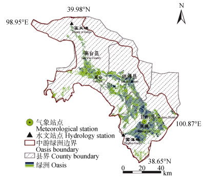
图1黑河中游区位图
Figure1.Map of the middle reaches of Heihe
 下载: 全尺寸图片幻灯片
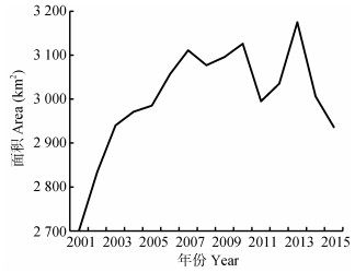
图22001-2015年黑河中游绿洲面积变化
Figure2.Changes of the oasis area in the middle reaches of Heihe from 2001 to 2015
下载: 全尺寸图片幻灯片
图32001-2015年黑河中游绿洲范围的时空变化图
Figure3.Scales of the oasis in the middle reaches of Heihe from 2001 to 2015
下载: 全尺寸图片幻灯片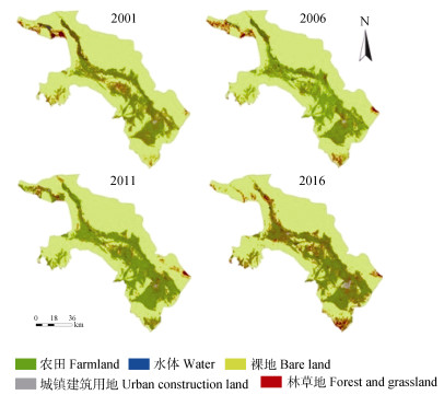
图4不同年份黑河中游绿洲区土地利用分类
Figure4.Classification of land use types in the oasis of the middle reaches of Heihe in 2001, 2006, 2011 and 2016
下载: 全尺寸图片幻灯片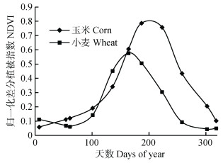
图5黑河中游绿洲区主要粮食作物NDVI时序曲线
Figure5.NDVI time series curves of main crops in the oasis of the middle reaches of Heihe
下载: 全尺寸图片幻灯片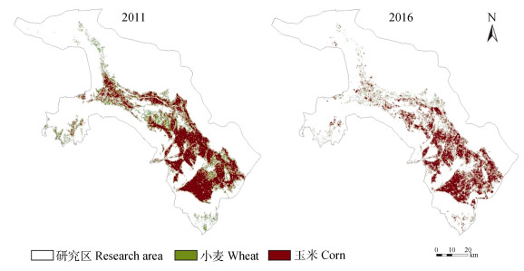
图6黑河中游绿洲小麦、玉米分布
Figure6.Distribution of wheat and corn in the oasis of the middle reaches of Heihe
下载: 全尺寸图片幻灯片表1黑河中游绿洲区土地覆被分类体系
Table1.Land cover classification system in the oasis of the middle reaches of Heihe
| 一级 First level | 二级 Second level | 分类描述 Classification description |
| 1农田 Farmland | 11小麦 Wheat | 种植小麦的耕地 Cultivated land for wheat |
| 12玉米 Corn | 种植玉米的耕地 Cultivated land for corn | |
| 13蔬菜 Vegetables | 种植蔬菜的耕地 Cultivated land for vegetables | |
| 14其他 Others | 种植其他作物的耕地 Cultivated land for other crops | |
| 2林地 Woodland | 长有木本植物的土地 Land with woody plants | |
| 3草地 Grassland | 长有草本植物的土地 Land with herbaceous plants | |
| 4水体 Water | 河流、湖泊、沼泽等大量含水区域 A large water bearing area, such as river, lake, marsh, etc. | |
| 5城镇建筑用地 Urban construction land | 城镇、乡村等人为建设用地 Construction land for towns, villages and others | |
| 6未利用地(裸地) Unused land (bare land) | 几乎无植被覆盖的土地 Almost no vegetation covered land |
下载: 导出CSV表21986年、1995年、2000年和2011年黑河中游绿洲区遥感监测绿洲面积与土地利用数据的相对误差
Table2.Relative errors in the oasis area of the middle reaches of Heihe between remote sensing monitoring date and land use data in 1986, 1995, 2000 and 2011
| 年份 Year | 土地利用数据 Land use data (km2) | 本研究估算 Calculation area of formula (km2) | 误差 Error (%) |
| 1986 | 2 049 | 2 386 | 16 |
| 1995 | 2 191 | 2 659 | 21 |
| 2000 | 2 261 | 2 559 | 13 |
| 2011 | 2 954 | 2 995 | 1 |
下载: 导出CSV表3黑河中游绿洲区土地利用分类面积
Table3.Areas of different land use types of the oasis in the middle reaches of Heihe
| km2 | ||||
| 土地利用类型 Land use type | 2001 | 2006 | 2011 | 2016 |
| 未利用地(裸地) Unused land (bare land) | 6 177.57 | 6 000.07 | 5 779.44 | 5 740.86 |
| 林地、草地 Woodland and grassland | 612.45 | 532.15 | 535.25 | 902.03 |
| 农田 Farmland | 1 668.11 | 1 898.89 | 2 137.04 | 1 759.46 |
| 城镇建筑用地 Urban construction land | 174.83 | 197.23 | 210.62 | 242.23 |
| 水体Water | 79.6 | 84.21 | 50.22 | 67.98 |
| 总计Total | 8 612.56 | 8 612.56 | 8 612.56 | 8 612.56 |
下载: 导出CSV表42011年和2016年黑河中游绿洲区各县玉米、小麦占比情况
Table4.Proportions of corn and wheat in each county of the oasis of the middle reaches of Heihe in 2011 and 2016
| % | ||||||
| 年份 Year | 数据类型 Data type | 作物 Crop | 高台县 Gaotai County | 临泽县 Linze County | 甘州区 Ganzhou District | 总计 Total |
| 2011 | HJ1A | 玉米 Corn | 42.0 | 54.9 | 62.4 | 61.3 |
| 小麦 Wheat | 15.6 | 11.8 | 9.4 | 11.7 | ||
| 2016 | 玉米 Corn | 30.9 | 52.5 | 61.3 | 61.0 | |
| 小麦 Wheat | 14.8 | 9.9 | 5.0 | 10.8 | ||
下载: 导出CSV参考文献
| [1] | 左玉珊. 基于MODIS数据的京津冀地区土地覆被分类方法研究[D]. 石家庄: 河北师范大学, 2015: 1-3 http://cdmd.cnki.com.cn/Article/CDMD-10094-1015354450.htm ZUO Y S. Research on land cover classification method of Beijing-Tianjin-Hebei Region Using MODIS data[D]. Shijiazhuang: Hebei Normal University, 2015: 1-3 http://cdmd.cnki.com.cn/Article/CDMD-10094-1015354450.htm |
| [2] | JUSTICE C, BECKER-RESHEF I. Report from the Workshop on Developing a Strategy for Global Agricultural Monitoring in the Framework of Group on Earth Observations (GEO)[R]. Rome: FAO, 2007: 1-67 |
| [3] | 邹健, 龙花楼.改革开放以来中国耕地利用与粮食生产安全格局变动研究[J].自然资源学报, 2009, 24(8):1366-1377 doi: 10.3321/j.issn:1000-3037.2009.08.005 ZOU J, LONG H L. The variation of farmland use and the security pattern of grain production in China since 1978[J]. Journal of Natural Resources, 2009, 24(8):1366-1377 doi: 10.3321/j.issn:1000-3037.2009.08.005 |
| [4] | 朱杰, 聂振邦, 马晓河. 21世纪中国粮食问题[M].北京:中国计划出版社, 1999 ZHU J, NIE Z B, MA X H. China's Grain Toward 21st Century[M]. Beijing:China Planning Press, 1999 |
| [5] | 张莉, 吴文斌, 杨鹏, 等.黑龙江省宾县农作物格局时空变化特征分析[J].中国农业科学, 2013, 46(15):3227-3237 doi: 10.3864/j.issn.0578-1752.2013.15.018 ZHANG L, WU W B, YANG P, et al. Temporal and spatial changes in crop patterns of Binxian County in Heilongjiang Province[J]. Scientia Agricultura Sinica, 2013, 46(15):3227-3237 doi: 10.3864/j.issn.0578-1752.2013.15.018 |
| [6] | Allen R, Hanuschak G, Craig M. History of remote sensing for crop acreage in USDA's National Agricultural Statistics Service[J]. Health Systems Review, 2002, 29(2):559-567 |
| [7] | 陈水森, 柳钦火, 陈良富, 等.粮食作物播种面积遥感监测研究进展[J].农业工程学报, 2005, 21(6):166-171 doi: 10.3321/j.issn:1002-6819.2005.06.037 CHEN S S, LIU Q H, CHEN L F, et al. Review of research advances in remote sensing monitoring of grain crop area[J]. Transactions of the CSAE, 2005, 21(6):166-171 doi: 10.3321/j.issn:1002-6819.2005.06.037 |
| [8] | 张健康, 程彦培, 张发旺, 等.基于多时相遥感影像的作物种植信息提取[J].农业工程学报, 2012, 28(2):134-141 doi: 10.3969/j.issn.1002-6819.2012.02.024 ZHANG J K, CHENG Y P, ZHANG F W, et al. Crops planting information extraction based on multi-temporal remote sensing images[J]. Transactions of the CSAE, 2012, 28(2):134-141 doi: 10.3969/j.issn.1002-6819.2012.02.024 |
| [9] | 陈亚宁, 陈忠升.干旱区绿洲演变与适宜发展规模研究——以塔里木河流域为例[J].中国生态农业学报, 2013, 21(1):134-140 http://www.ecoagri.ac.cn/zgstny/ch/reader/view_abstract.aspx?file_no=2013117&flag=1 CHEN Y N, CHEN Z S. Analysis of oasis evolution and suitable development scale for arid regions:A case study of the Tarim River Basin[J]. Chinese Journal of Eco-Agriculture, 2013, 21(1):134-140 http://www.ecoagri.ac.cn/zgstny/ch/reader/view_abstract.aspx?file_no=2013117&flag=1 |
| [10] | 郝丽娜, 粟晓玲.黑河干流中游地区适宜绿洲及耕地规模确定[J].农业工程学报, 2015, 31(10):262-268 doi: 10.11975/j.issn.1002-6819.2015.10.035 HAO L N, SU X L. Determination for suitable scale of oasis and cultivated land in middle reaches of Heihe River Basin[J]. Transactions of the CSAE, 2015, 31(10):262-268 doi: 10.11975/j.issn.1002-6819.2015.10.035 |
| [11] | 潘学鹏, 李改欣, 刘峰贵, 等.华北平原冬小麦面积遥感提取及时空变化研究[J].中国生态农业学报, 2015, 23(4):497-505 http://www.ecoagri.ac.cn/zgstny/ch/reader/view_abstract.aspx?file_no=2015414&flag=1 PAN X P, LI G X, LIU F G, et al. Using remote sensing to determine spatio-temporal variations in winter wheat growing area in the North China Plain[J]. Chinese Journal of Eco-Agriculture, 2015, 23(4):497-505 http://www.ecoagri.ac.cn/zgstny/ch/reader/view_abstract.aspx?file_no=2015414&flag=1 |
| [12] | 王红营, 潘学鹏, 罗建美, 等.基于遥感的华北平原农作物时空分布变化特征分析[J].中国生态农业学报, 2015, 23(9):1199-1209 http://www.ecoagri.ac.cn/zgstny/ch/reader/view_abstract.aspx?file_no=2015915&flag=1 WANG H Y, PAN X P, LUO J M, et al. Using remote sensing to analyze spatiotemporal variations in crop planting in the North China Plain[J]. Chinese Journal of Eco-Agriculture, 2015, 23(9):1199-1209 http://www.ecoagri.ac.cn/zgstny/ch/reader/view_abstract.aspx?file_no=2015915&flag=1 |
| [13] | 钱大文, 巩杰, 高彦净.近35年黑河中游临泽县荒漠化时空分异及景观格局变化[J].干旱区资源与环境, 2015, 29(4):85-90 http://d.old.wanfangdata.com.cn/Periodical/ghqzyyhj201504015 QIAN D W, GONG J, GAO Y J. Spatial-temporal difference and landscape pattern evolution of desertification in the middle reaches of the Heihe River:A case study of Linze County in Gansu[J]. Journal of Arid Land Resources and Environment, 2015, 29(4):85-90 http://d.old.wanfangdata.com.cn/Periodical/ghqzyyhj201504015 |
| [14] | 袁春霞. 黑河流域绿洲时空变化过程的驱动机制研究[D]. 兰州: 兰州大学, 2015 http://cdmd.cnki.com.cn/Article/CDMD-10730-1015342075.htm YUAN C X. Study on the driving mechanism of the oasis dynamic changes in Heihe River Basin[D]. Lanzhou: Lanzhou University, 2015 http://cdmd.cnki.com.cn/Article/CDMD-10730-1015342075.htm |
| [15] | 吴喜芳, 李改欣, 潘学鹏, 等.黄河源区植被覆盖度对气温和降水的响应研究[J].资源科学, 2015, 37(3):512-521 http://d.old.wanfangdata.com.cn/Periodical/zykx201503011 WU X F, LI G X, PAN X P, et al. Response of vegetation cover to temperature and precipitation in the source region of the Yellow River[J]. Resources Science, 2015, 37(3):512-521 http://d.old.wanfangdata.com.cn/Periodical/zykx201503011 |
| [16] | HANSEN M C, REED B. A comparison of the IGBP Discover and University of Maryland 1 km global land cover products[J]. International Journal of Remote Sensing, 2000, 21(6/7):1365-1373 http://www.wanfangdata.com.cn/details/detail.do?_type=perio&id=JJ025730147 |
| [17] | 刘勇洪, 牛铮, 徐永明, 等.基于MODIS数据设计的中国土地覆盖分类系统与应用研究[J].农业工程学报, 2006, 22(5):99-104 doi: 10.3321/j.issn:1002-6819.2006.05.023 LIU Y H, NIU Z, XU Y M, et al. Design of land cover classification system for China and its application research based on MODIS data[J]. Transactions of the CSAE, 2006, 22(5):99-104 doi: 10.3321/j.issn:1002-6819.2006.05.023 |
| [18] | 刘志刚, 史文中, 李德仁, 等.一种基于支撑向量机的遥感影像不完全监督分类新方法[J].遥感学报, 2005, 9(4):363-373 http://d.old.wanfangdata.com.cn/Periodical/ygxb200504005 LIU Z G, SHI W Z, LI D R, et al. Partially supervised classification of remotely sensed imagery using support vector machines[J]. Journal of Remote Sensing, 2005, 9(4):363-373 http://d.old.wanfangdata.com.cn/Periodical/ygxb200504005 |
| [19] | JAKUBAUSKAS M E, LEGATES D R, KASTENS J H. Crop identification using harmonic analysis of time-series AVHRR NDVI data[J]. Computers and Electronics in Agriculture, 2002, 37(1/3):127-139 http://cn.bing.com/academic/profile?id=3a3e16cd8ba3efdd214118a0f41da324&encoded=0&v=paper_preview&mkt=zh-cn |
| [20] | 于信芳, 庄大方.基于MODIS NDVI数据的东北森林物候期监测[J].资源科学, 2006, 28(4):111-117 doi: 10.3321/j.issn:1007-7588.2006.04.023 YU X F, ZHUANG D F. Monitoring forest phenophases of northeast China based on MODIS NDVI data[J]. Resources Science, 2006, 28(4):111-117 doi: 10.3321/j.issn:1007-7588.2006.04.023 |
| [21] | 左丽君, 董婷婷, 汪潇, 等.基于MODIS/EVI的中国北方耕地复种指数提取[J].农业工程学报, 2009, 25(8):141-146 doi: 10.3969/j.issn.1002-6819.2009.08.026 ZUO L J, DONG T T, WANG X, et al. Multiple cropping index of Northern China based on MODIS/EVI[J]. Transactions of the CSAE, 2009, 25(8):141-146 doi: 10.3969/j.issn.1002-6819.2009.08.026 |
| [22] | 潘学鹏. 华北平原主要作物遥感提取及时空变化研究[D]. 西宁: 青海师范大学, 2015 http://www.scholarmate.com/pubweb/outside/pdwhdetails?param=Z_iris_plus_TnDogBBaNRFpTq1Hgurg==,4,zh_cn PAN X P. Spatio-temporal variation of main crops planting area in the North China Plain using remote sensing data[D]. Xining: Qinghai Normal University, 2015 http://www.scholarmate.com/pubweb/outside/pdwhdetails?param=Z_iris_plus_TnDogBBaNRFpTq1Hgurg==,4,zh_cn |
| [23] | BREIMAN L, FRIEDMAN J H, OLSHEN R A, et al. Classification and Regression Trees[M]. Belmont:Wadsworth International Group, 1984:1-358 |
| [24] | YOHANNES Y, HODDINOTT J. Classification and Regression Trees:An Introduction[M]. Washington:International Food Policy Research Institute, 1999:1-29 |
