许皞1, 2,,,
王耀3,
李航2,
沈文东2
1.河北农业大学国土资源学院 保定 071000
2.河北农业大学资源与环境科学学院 保定 071000
3.河北农业大学商学院 保定 071000
基金项目: 河北省社会科学基金HB16YJ060
河北省社会科学发展研究课题201603120411
详细信息
作者简介:刘建华, 研究方向为土地资源利用与规划。E-mail:liu_jianhua1@163.com
通讯作者:许皞, 研究方向为土壤学与土地资源可持续利用。E-mail:xuhao22003@126.com
中图分类号:S156.4计量
文章访问数:760
HTML全文浏览量:0
PDF下载量:547
被引次数:0
出版历程
收稿日期:2017-10-31
录用日期:2018-04-12
刊出日期:2018-08-01
Evaluation of ecological risk and carbon fixation from land use change: A case study of Huanghua City, Hebei ProvinceE
LIU Jianhua1,,XU Hao1, 2,,,
WANG Yao3,
LI Hang2,
SHEN Wendong2
1. College of Land and Resources, Hebei Agricultural University, Baoding 071000, China
2. College of Resources and Environmental Science, Hebei Agricultural University, Baoding 071000, China
3. College of Business Studies, Hebei Agricultural University, Baoding 071000, China
Funds: the Social Science Fund of Hebei Province, ChinaHB16YJ060
the Hebei Province Social Development Research Project201603120411
More Information
Corresponding author:XU Hao, E-mail:xuhao22003@126.com
摘要
HTML全文
图
参考文献
相关文章
施引文献
资源附件
访问统计
摘要
摘要:土地利用格局的变化会引起区域生态风险和固碳功能的变化。本文以河北省黄骅市为例,以1995年、2005年和2015年遥感影像为基础数据,基于土地利用格局变化构建生态风险指数,利用InVEST模型分析碳储量服务变化,并对二者进行相关性分析,以期为土地资源的合理利用提供科学依据。结果表明:1)1995-2015年,黄骅市主要土地利用类型为耕地、盐碱地和建设用地,对比2015年和1995年的结果发现,耕地、草地和建设用地破碎度和分离度增加,园地和盐碱地分离度和破碎度降低;园地和盐碱地损失度指数降低,而其他土地利用类型损失度指数增加。2)1995年、2005年和2015年黄骅市生态风险总和分别为12.58、10.32和11.10,生态风险区以较低风险区和高风险区为主,较低风险区面积逐渐增加且向南部集中,高风险区面积逐渐减少且向中部和东部海岸带集中。3)InVEST模拟结果表明,研究期间黄骅市碳储量呈现先上升后下降的趋势,1995年、2005年和2015年黄骅市的碳储量分别为2 387.05万t、2 491.51万t和2 028.86万t,3年的碳密度分别为107.63 t·hm-2、112.34 t·hm-2和93.16 t·hm-2,各土地利用类型碳储量的变化情况与各自面积的变化情况有较高的一致性。4)生态风险变化与碳储量服务变化的相关性分析结果表明,1995—2005年和2005—2015年二者相关性的决定系数分别为0.69和0.72(P < 0.01),呈显著负相关关系,表明生态系统服务变化在生态风险评价中应用的可能。基于土地利用格局变化对黄骅市生态风险和碳储量进行评价,对于其实现土地资源可持续利用和区域生态环境改善具有重要意义。
关键词:土地利用格局/
生态风险/
碳储量/
生态系统服务/
InVEST模型
Abstract:The rapid development of social economy has had a profound impact on the change of land use pattern. Ecological risk assessment had played an important role in controlling ecological risk and realizing sustainable development. Changes in land use pattern will exert an effect on regional ecological risk and carbon sequestration. Combined evaluation of ecological service value and ecological risk assessment has become the new mode of studying ecological problems. This paper used Huanghua City in Hebei Province, China as a case study and remote sensing images for 1995, 2005 and 2015 as the basic data to analyze this pattern change. While ecological risk index was constructed based on the pattern of change in land use, InVEST was used to analyze the change in carbon storage. Finally, we analyzed the correlation between changes in ecological risk and carbon stock. The purpose of the study was to determine rational utilization of land resources for healthy development of ecological environment. The results showed that:1) cultivated land, saline land and construction land were the main land use patterns in Huanghua during 1995-2015. Compared 2015 with 1995, the degrees of fragmentation and separation in cultivated land, grassland and construction land increased, while the separation and fragmentation of garden plot and saline land decreased. While the loss index of garden plot and the saline land reduced, that of other land use types increased. 2) Total ecological risks of Huanghua City in 1995, 2005 and 2015 were 12.58, 10.32 and 11.10, respectively. During the study period, low risk and high risk area constituted the main risk areas. The area of the low risk gradually increased and was concentrated in the south. Then the area of high risk gradually decreased and was concentrated in the central and eastern coastal zones. 3) According to InVEST simulation results, the carbon storage in Huanghua City increased and then decreased eventually. In 1995, 2005 and 2015, total carbon storages in Huanghua were 23.870 5 million tons, 24.915 1 million tons and 20.288 6 million tons, with respective carbon densities of 107.63 t·hm-2, 112.34 t·hm-2 and 93.16 t·hm-2. Change in carbon storage under each land use pattern was more consistent with change in the corresponding land area. 4) Correlation between changes in ecological risk and carbon stock was significant. The determinants of the correlation between changes in ecological risk and carbon stock in 1995-2005 and 2005-2015 were 0.69 and 0.72 (P < 0.01), showing a significant negative correlation. It suggested that ecological risk assessment and ecosystem services valuation were concurrently assessable. This was one of the innovative points of the research. The assessment of ecological risk and carbon storage in Huanghua using change in land use pattern was important for the realization of sustainable utilization of land resources and improvements in regional ecological environment.
Key words:Land use pattern/
Ecological risk/
Carbon storage/
Ecological system services/
InVEST model
HTML全文
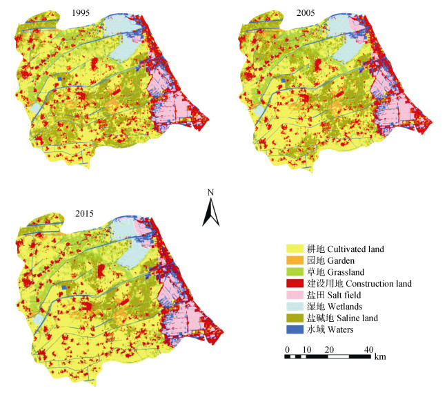
图11995—2015年黄骅市土地利用类型空间分布图
Figure1.Spatial distribution maps of land use types of Huanghua City in 1995, 2005 and 2015
 下载: 全尺寸图片幻灯片
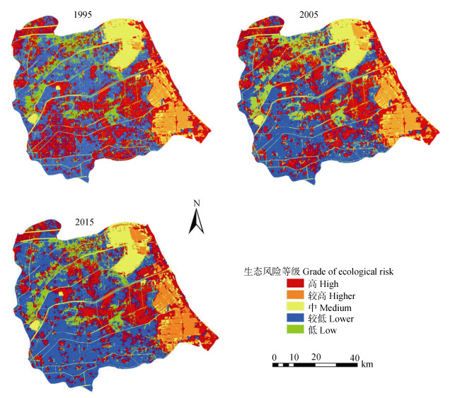
图21995—2015年黄骅市生态风险等级的空间分布特征
Figure2.Spatial distribution maps of ecological risk grades of Huanghua City in 1995, 2005 and 2015
下载: 全尺寸图片幻灯片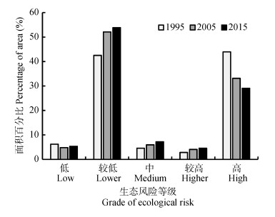
图31995—2015年黄骅市生态风险等级面积比例
Figure3.Area proportions of different ecological risk grades of Huanghua City in 1995, 2005 and 2015
下载: 全尺寸图片幻灯片
图41995—2005年(a)和2005—2015年(b)生态风险变化与碳储量变化关系
Figure4.Relationship between ecological risk change and carbon storage change in 1995-2005 (a) and 2005-2015 (b)
下载: 全尺寸图片幻灯片表1黄骅市不同土地利用类型碳密度参数
Table1.Carbon density parameters of different land use types in Huanghua City
| t?hm-2 | ||||
| 土地利用类型 Land use type | 地上部分碳 Aboveground carbon | 地下部分碳 Underground partial carbon | 土壤碳 Soil carbon | 死亡有机碳 Death organic carbon |
| 耕地Cultivated land | 3.59 | 0.68 | 90.56 | 0.72 |
| 园地Garden plot | 2.00 | 0.10 | 112.80 | 0.18 |
| 草地Grassland | 2.25 | 11.70 | 101.27 | 0.45 |
| 建设用地Construction land | 0.83 | 0.08 | 43.71 | 0.00 |
| 盐田Salt field | 0.00 | 0.00 | 13.50 | 0.00 |
| 湿地Wetland | 4.50 | 0.67 | 87.47 | 0.00 |
| 盐碱地Saline land | 0.00 | 0.00 | 25.30 | 0.00 |
| 水域Waters | 0.00 | 0.00 | 0.00 | 0.00 |
| 地上部分碳密度、地下部分碳密度和土壤碳密度参考李克让等[18]的研究; 死亡有机碳密度参考汤洁等[20]研究。Aboveground carbon density, underground carbon density and soil carbon density refer to the study of LI Kerang, et al[18]; Death organic carbon refers to the study of TANG Jie, et al[20]. | ||||
下载: 导出CSV表21995—2015年黄骅市不同土地类型面积统计
Table2.Areas of different land use types in Huanghua City in 1995, 2005 and 2015
| 土地利用类型 Land use type | 1995 | 2005 | 2015 | |||||
| 面积 Area (km2) | 比例 Proportion (%) | 面积 Area (km2) | 比例 Proportion (%) | 面积 Area (km2) | 比例 Proportion (%) | |||
| 耕地Cultivated land | 802.24 | 36.84 | 793.11 | 36.42 | 780.82 | 35.85 | ||
| 园地Garden plot | 52.08 | 2.43 | 53.74 | 2.47 | 54.26 | 2.49 | ||
| 草地Grassland | 56.71 | 2.60 | 54.39 | 2.50 | 50.68 | 2.33 | ||
| 建设用地Construction land | 388.19 | 17.82 | 394.46 | 18.11 | 418.61 | 19.22 | ||
| 盐田Salt field | 131.12 | 6.02 | 155.2 | 7.13 | 170.03 | 7.81 | ||
| 湿地Wetland | 115.81 | 5.32 | 103.08 | 4.73 | 91.51 | 4.20 | ||
| 盐碱地Saline land | 492.17 | 22.60 | 481.38 | 22.10 | 470.16 | 21.59 | ||
| 水域Waters | 138.77 | 6.37 | 142.48 | 6.54 | 141.76 | 6.51 | ||
| 总计Total | 2 177.83 | 100.00 | 2 177.83 | 100.00 | 2 177.83 | 100.00 | ||
下载: 导出CSV表31995—2015年黄骅市不同土地利用类型的景观格局指数的变化
Table3.Changes of landscape pattern indexes of different land use types of Huanghua City in 1995, 2005 and 2015
| 景观格局指数 Landscape pattern index | 年份 Year | 耕地 Cultivated land | 园地 Garden plot | 草地 Grassland | 建设用地 Land used for building | 盐田 Salt field | 湿地 Wetland | 盐碱地 Saline land | 水域 Waters |
| 斑块数 Patch number | 1995 | 1 653 | 67 | 219 | 252 | 26 | 3 | 1 206 | 100 |
| 2005 | 1 975 | 67 | 71 | 434 | 29 | 6 | 698 | 98 | |
| 2015 | 2 319 | 14 | 228 | 703 | 37 | 6 | 635 | 157 | |
| 破碎度 Fragmentation | 1995 | 2.06 | 1.29 | 3.86 | 0.65 | 0.20 | 0.03 | 2.45 | 0.72 |
| 2005 | 2.49 | 1.24 | 1.31 | 1.10 | 0.19 | 0.06 | 1.45 | 0.69 | |
| 2015 | 2.97 | 0.25 | 4.49 | 1.68 | 0.22 | 0.07 | 1.35 | 1.11 | |
| 分离度 Separation | 1995 | 1.18 | 3.67 | 6.09 | 0.95 | 0.91 | 0.37 | 1.64 | 1.68 |
| 2005 | 1.29 | 3.66 | 3.47 | 1.25 | 0.97 | 0.50 | 1.25 | 1.67 | |
| 2015 | 1.40 | 1.65 | 6.21 | 1.59 | 1.08 | 0.51 | 1.19 | 2.11 | |
| 优势度 Dominance | 1995 | 0.71 | 0.03 | 0.09 | 0.11 | 0.01 | 0.001 | 0.52 | 0.04 |
| 2005 | 0.45 | 0.02 | 0.02 | 0.16 | 0.05 | 0.03 | 0.22 | 0.05 | |
| 2015 | 0.44 | 0.02 | 0.04 | 0.18 | 0.05 | 0.03 | 0.19 | 0.05 | |
| 干扰度 Interference | 1995 | 1.21 | 1.14 | 2.42 | 0.44 | 0.28 | 0.08 | 1.32 | 1.32 |
| 2005 | 1.23 | 1.11 | 1.10 | 0.66 | 0.28 | 0.13 | 0.80 | 0.80 | |
| 2015 | 1.39 | 0.42 | 2.61 | 0.91 | 0.31 | 0.14 | 0.74 | 0.78 | |
| 损失度 Loss | 1995 | 0.15 | 0.11 | 0.19 | 0.01 | 0.06 | 0.01 | 0.23 | 0.08 |
| 2005 | 0.15 | 0.11 | 0.08 | 0.01 | 0.06 | 0.02 | 0.14 | 0.08 | |
| 2015 | 0.17 | 0.04 | 0.21 | 0.02 | 0.07 | 0.02 | 0.13 | 0.11 |
下载: 导出CSV表41995—2015年黄骅市不同土地利用类型碳储量和碳密度
Table4.Carbon storages and carbon densities of different land use types of Huanghua City in 1995, 2005 and 2015
| 土地利用类型 Land use type | 碳储量Carbon storage (×104 t) | 碳密度Carbon density (t·km-2) | |||||
| 1995 | 2005 | 2015 | 1995 | 2005 | 2015 | ||
| 耕地Cultivated land | 889.41 | 947.02 | 715.58 | 11 086.64 | 11 940.63 | 9 164.45 | |
| 园地Garden plot | 305.06 | 306.21 | 248.94 | 58 573.98 | 56 979.27 | 45 879.31 | |
| 草地Grassland | 150.38 | 127.07 | 101.85 | 26 518.10 | 23 362.20 | 20 096.44 | |
| 建设用地Construction land | 309.36 | 355.29 | 311.63 | 7 969.34 | 9 006.98 | 7 444.47 | |
| 盐田Salt field | 133.20 | 162.70 | 147.30 | 10 158.43 | 10 482.96 | 8 662.90 | |
| 湿地Wetland | 100.73 | 80.97 | 97.39 | 8 698.17 | 7 855.46 | 10 642.04 | |
| 盐碱地Saline land | 498.89 | 512.25 | 406.18 | 10 136.61 | 10 641.37 | 8 639.14 | |
| 水域Waters | 0.00 | 0.00 | 0.00 | 0.00 | 0.00 | 0.00 | |
| 总计Total | 2 387.05 | 2 491.51 | 2 028.86 | ||||
下载: 导出CSV参考文献
| [1] | HUNSAKER C T, GRAHAM R L, SUTER Ⅱ G W, et al. Assessing ecological risk on a regional scale[J]. Environmental Management, 1990, 14(3):325-332 doi: 10.1007/BF02394200 |
| [2] | 傅伯杰, 陈利顶, 王军, 等.土地利用结构与生态过程[J].第四纪研究, 2003, 23(3):247-255 http://www.wanfangdata.com.cn/details/detail.do?_type=perio&id=stjj200503012 FU B J, CHEN L D, WANG J, et al. Land use structure and ecological process[J]. Quaternary Sciences, 2003, 23(3):247-255 http://www.wanfangdata.com.cn/details/detail.do?_type=perio&id=stjj200503012 |
| [3] | 刘纪远, 匡文慧, 张增祥, 等. 20世纪80年代末以来中国土地利用变化的基本特征与空间格局[J].地理学报, 2014, 69(1):3-14 doi: 10.11821/dlxb201401001 LIU J Y, KUANG W H, ZHANG Z X, et al. Spatiotemporal characteristics, patterns and causes of land use changes in China since the late 1980s[J]. Acta Geographica Sinica, 2014, 69(1):3-14 doi: 10.11821/dlxb201401001 |
| [4] | 肖杨, 毛显强.区域景观生态风险空间分析[J].中国环境科学, 2006, 26(5):623-626 http://www.cnki.com.cn/Article/CJFDTOTAL-DLXB605.007.htm XIAO Y, MAO X Q. Spatial analysis of regional landscape ecological risk[J]. China Environmental Science, 2006, 26(5):623-626 http://www.cnki.com.cn/Article/CJFDTOTAL-DLXB605.007.htm |
| [5] | 曾辉, 刘国军.基于景观结构的区域生态风险分析[J].中国环境科学, 1999, 19(5):454-457 doi: 10.11821/dlxb201504013 ZENG H, LIU G J. Analysis of regional ecological risk based on landscape structure[J]. China Environmental Science, 1999, 19(5):454-457 doi: 10.11821/dlxb201504013 |
| [6] | 巫丽芸. 区域景观生态风险评价及生态风险管理研究[D]. 福州: 福建师范大学, 2004 http://cdmd.cnki.com.cn/Article/CDMD-10394-2004095204.htm WU L Y. The study of regional landscape ecological risk assessment and the environmental risk management countermeasure[D]. Fuzhou:Fujian Normal University, 2004 http://cdmd.cnki.com.cn/Article/CDMD-10394-2004095204.htm |
| [7] | 傅伯杰, 张立伟.土地利用变化与生态系统服务:概念、方法与进展[J].地理科学进展, 2014, 33(4):441-446 doi: 10.11820/dlkxjz.2014.04.001 FU B J, ZHANG L W. Land-use change and ecosystem services:Concepts, methods and progress[J]. Progress in Geography, 2014, 33(4):441-446 doi: 10.11820/dlkxjz.2014.04.001 |
| [8] | 欧阳志云, 王效科, 苗鸿.中国陆地生态系统服务功能及其生态经济价值的初步研究[J].生态学报, 1999, 19(5):607-613 http://www.cnki.com.cn/Article/CJFDTotal-ZRZY201509008.htm OUYANG Z Y, WANG X K, MIAO H. Preliminary study on terrestrial ecosystem services and its ecological economic value in China[J]. Acta Ecologica Sinica, 1999, 19(5):607-613 http://www.cnki.com.cn/Article/CJFDTotal-ZRZY201509008.htm |
| [9] | 谢高地, 张彩霞, 张雷明, 等.基于单位面积价值当量因子的生态系统服务价值化方法改进[J].自然资源学报, 2015, 30(8):1243-1254 doi: 10.11849/zrzyxb.2015.08.001 XIE G D, ZHANG C X, ZHANG L M, et al. Improvement of the evaluation method for ecosystem service value based on per unit area[J]. Journal of Natural Resources, 2015, 30(8):1243-1254 doi: 10.11849/zrzyxb.2015.08.001 |
| [10] | CAO S J, LI C, CAO S H, et al. Change in ecosystem service value arising from land consolidation planning in Anhui Province[J]. Asian Agricultural Research, 2013, 5(1):13-16 http://www.cabdirect.org/abstracts/20133074465.html |
| [11] | 康鹏, 陈卫平, 王美娥.基于生态系统服务的生态风险评价研究进展[J].生态学报, 2016, 36(5):1192-1203 http://www.cnki.com.cn/Article/CJFDTotal-ZRZY201509008.htm KANG P, CHEN W P, WANG M E. Advances in ecosystem service-based ecological risk assessment[J]. Acta Ecologica Sinica, 2016, 36(5):1192-1203 http://www.cnki.com.cn/Article/CJFDTotal-ZRZY201509008.htm |
| [12] | 彭建, 党威雄, 刘焱序, 等.景观生态风险评价研究进展与展望[J].地理学报, 2015, 70(4):664-677 http://www.geog.com.cn/CN/volumn/volumn_3294.shtml PENG J, DANG W X, LIU Y X, et al. Review on landscape ecological risk assessment[J]. Acta Geographica Sinica, 2015, 70(4):664-677 http://www.geog.com.cn/CN/volumn/volumn_3294.shtml |
| [13] | 贾芳芳. 基于InVEST模型的赣江流域生态系统服务功能评估[D]. 北京: 中国地质大学(北京), 2014 http://cdmd.cnki.com.cn/article/cdmd-11415-1014238256.htm JIA F F. InVEST model based ecosystem services evaluation with case study on Ganjiang River Basin[D]. Beijing:China University of Geosciences (Beijing), 2014 http://cdmd.cnki.com.cn/article/cdmd-11415-1014238256.htm |
| [14] | 韩晋榕. 基于InVEST模型的城市扩张对碳储量的影响分析[D]. 长春: 东北师范大学, 2013 http://cdmd.cnki.com.cn/Article/CDMD-10200-1013363008.htm HAN J R. The impact of urban sprawl on carbon stocks based on the InVEST model[D]. Changchun:Northeast Normal University, 2013 http://cdmd.cnki.com.cn/Article/CDMD-10200-1013363008.htm |
| [15] | LI X W, LI M D, DONG S K, et al. Temporal-spatial changes in ecosystem services and implications for the conservation of alpine rangelands on the Qinghai-Tibetan Plateau[J]. The Rangeland Journal, 2015, 37(1):31-43 doi: 10.1071/RJ14084 |
| [16] | LEH M D K, MATOCK M D, CUMMINGS E C, et al. Quantifying and mapping multiple ecosystem services change in West Africa[J]. Agriculture Ecosystems & Environment, 2013, 165:6-18 http://www.sciencedirect.com/science/article/pii/S0167880912004343 |
| [17] | 艾建超, 赵力, 程龙飞, 等.土地整理进程中镇赉项目区景观格局变化及生态风险[J].东北师大学报:自然科学版, 2013, 45(2):146-152 http://www.cqvip.com/QK/90785X/201302/46281706.html AI J C, ZHAO L, CHENG L F, et al. A study on landscape pattern change and ecological risk of Zhenlai land consolidation project[J]. Journal of Northeast Normal University:Natural Science Edition, 2013, 45(2):146-152 http://www.cqvip.com/QK/90785X/201302/46281706.html |
| [18] | 李克让, 王绍强, 曹明奎.中国植被和土壤碳贮量[J].中国科学(D辑), 2003, 33(1):72-80 http://www.cnki.com.cn/Article/CJFDTOTAL-LYKE201110005.htm LI K R, WANG S Q, CAO M K. Vegetation and soil carbon storage in China[J]. Science in China (Series D), 2003, 33(1):72-80 http://www.cnki.com.cn/Article/CJFDTOTAL-LYKE201110005.htm |
| [19] | 黄玫, 季劲钧, 曹明奎, 等.中国区域植被地上与地下生物量模拟[J].生态学报, 2006, 26(12):4156-4163 doi: 10.3321/j.issn:1000-0933.2006.12.031 HUANG M, JI J J, CAO M Q, et al. Modeling study of vegetation shoot and root biomass in China[J]. Acta Ecologica Sinica, 2006, 26(12):4156-4163 doi: 10.3321/j.issn:1000-0933.2006.12.031 |
| [20] | 汤洁, 张楠, 李昭阳, 等.吉林西部不同土地利用类型的土壤有机碳垂向分布和碳密度[J].吉林大学学报:地球科学版, 2011, 41(4):1151-1156 https://www.researchgate.net/profile/Xiaoming_Xu9/publication/288420301_Vertical_distribution_of_soil_organic_carbon_and_carbon_density_under_different_land_use_types_in_western_Jilin_Province/links/5796444b08aeb0ffcd058b13.pdf?origin=publication_list TANG J, ZHANG N, LI Z Y, et al. Vertical distribution of soil organic carbon and carbon density under different land use types in western Jilin Province[J]. Journal of Jilin University:Earth Science Edition, 2011, 41(4):1151-1156 https://www.researchgate.net/profile/Xiaoming_Xu9/publication/288420301_Vertical_distribution_of_soil_organic_carbon_and_carbon_density_under_different_land_use_types_in_western_Jilin_Province/links/5796444b08aeb0ffcd058b13.pdf?origin=publication_list |
| [21] | 宋珂, 宋喧, 韩涛.基于景观结构的经济发达地区生态风险评价——以昆山市为例[J].江西农业学报, 2015, 27(1):104-109 http://kns.cnki.net/KCMS/detail/detail.aspx?filename=jxny201501028&dbname=CJFD&dbcode=CJFQ SONG K, SONG X, HAN T. Evaluation of ecological risk in developed regions based on landscape structure:A case study of Kunshan City[J]. Acta Agriculturae Jiangxi, 2015, 27(1):104-109 http://kns.cnki.net/KCMS/detail/detail.aspx?filename=jxny201501028&dbname=CJFD&dbcode=CJFQ |
| [22] | 胡和兵, 刘红玉, 郝敬锋, 等.流域景观结构的城市化影响与生态风险评价[J].生态学报, 2011, 31(12):3432-3440 http://www.cnki.com.cn/Article/CJFDTOTAL-DLXB605.007.htm HU H B, LIU H Y, HAO J F, et al. The urbanization effects on watershed landscape structure and their ecological risk assessment[J]. Acta Ecologica Sinica, 2011, 31(12):3432-3440 http://www.cnki.com.cn/Article/CJFDTOTAL-DLXB605.007.htm |
| [23] | 高宾, 李小玉, 李志刚, 等.基于景观格局的锦州湾沿海经济开发区生态风险分析[J].生态学报, 2011, 31(12):3441-3450 http://mall.cnki.net/magazine/article/STXB201112024.htm GAO B, LI X Y, LI Z G, et al. Assessment of ecological risk of coastal economic developing zone in Jinzhou Bay based on landscape pattern[J]. Acta Ecologica Sinica, 2011, 31(12):3441-3450 http://mall.cnki.net/magazine/article/STXB201112024.htm |
| [24] | 卿凤婷, 彭羽.基于景观结构的北京市顺义区生态风险时空特征[J].应用生态学报, 2016, 27(5):1585-1593 https://www.researchgate.net/publication/305430834_Temporal_and_spatial_characteristics_of_ecological_risk_in_Shunyi_Beijing_China_based_on_landscape_structure QING F T, PENG Y. Temporal and spatial characteristics of ecological risk in Shunyi, Beijing, China based on landscape structure[J]. Chinese Journal of Applied Ecology, 2016, 27(5):1585-1593 https://www.researchgate.net/publication/305430834_Temporal_and_spatial_characteristics_of_ecological_risk_in_Shunyi_Beijing_China_based_on_landscape_structure |
| [25] | 黄卉. 基于InVEST模型的土地利用变化与碳储量研究[D]. 北京: 中国地质大学(北京), 2015 http://cdmd.cnki.com.cn/Article/CDMD-11415-1015385425.htm HUANG H. Research on land use/land cover change and carbon storage based on InVEST model[D]. Beijing:China University of Geosciences (Beijing), 2015 http://cdmd.cnki.com.cn/Article/CDMD-11415-1015385425.htm |
