牛志君1,
康薇1,
张立强2,
张俊梅2
1.河北农业大学资源与环境科学学院 保定 071000
2.河北农业大学国土资源学院 保定 071000
基金项目: 河北省社会科学基金项目HB16YJ060
详细信息
作者简介:王晓晴, 研究方向为土壤与土地资源持续利用。E-mail:594585904@qq.com
中图分类号:S154.1计量
文章访问数:786
HTML全文浏览量:1
PDF下载量:592
被引次数:0
出版历程
收稿日期:2017-11-24
录用日期:2018-02-05
刊出日期:2018-06-01
Analysis of ecological service value of ecological land of Bashang area based on ecological factor division
WANG Xiaoqing1,,,NIU Zhijun1,
KANG Wei1,
ZHANG Liqiang2,
ZHANG Junmei2
1. College of Resources and Environmental Sciences, Hebei Agricultural University, Baoding 071000, China
2. College of Land Resources, Hebei Agricultural University, Baoding 071000, China
Funds: the Social Science Foundation of Hebei ProvinceHB16YJ060
More Information
Corresponding author:WANG Xiaoqing, E-mail:594585904@qq.com
摘要
HTML全文
图
参考文献
相关文章
施引文献
资源附件
访问统计
摘要
摘要:坝上地区是京津冀地区的重要生态屏障,也是京津冀的重要水源涵养地和生物多样性保护重要基地,对保障京津冀地区的生态安全和水资源供给有着不可替代的作用。本研究运用软件ARCGIS 10.2,将坝上地区的土壤类型与地貌类型两大主要土地生态要素进行叠加,划分典型类型区,并结合现行的土地利用分类系统和生态系统服务功能,构建生态用地分类体系,在此基础上,以粮食单产进行区位修订,采用当量因子法估算2015年坝上各类型分区内生态用地的生态系统服务价值,以期为坝上地区的生态用地格局规划与区域生态保护管理政策制定提供理论依据。结果表明:1)河北省坝上地区粮食单产大体趋势是自中部向两翼方向逐渐递增,高产区主要是东南部的褐土侵蚀剥蚀低山类型区和褐土侵蚀剥蚀中山类型区,产量高达5 000 kg·hm-2以上;低产区则是主要位于西南的张北县栗钙土玄武岩台地类型区和尚义县粗骨土侵蚀剥蚀中山类型区,产量不足2 500 kg·hm-2。2)河北省坝上生态用地类型以草地和林地为主,两者面积之和占总面积的73.95%。沼泽土侵蚀剥蚀中山类型区、沼泽土冲积风积高原类型区、灰色森林土侵蚀剥蚀中山类型区以及灰色森林土冲积风积高原类型区的生态用地面积占其类型区总面积的95%以上,而盐土湖积高原类型区的生态用地所占比例最小,仅占39.74%。3)2015年坝上生态服务总价值高达634.77亿元,其中坝上地区东部的棕壤侵蚀剥蚀中山类型区生态服务价值最大,主要由林地提供;位于西北部的盐土湖积高原类型区生态服务价值最小,基本为草地所提供。本研究表明,不同的土壤类型和地貌类型均影响着土地生产能力的大小,从而影响着该地区的生态系统服务价值大小。
关键词:土地生态要素/
土壤类型/
地貌类型/
生态用地/
生态服务价值/
坝上
Abstract:As a vital ecological barrier and biodiversity conservation base of the Beijing-Tianjin-Hebei Region, Bashang area plays an irreplaceable role in guaranteeing ecological security and water resources supply. In this study, the ARCGIS 10.2 software was used to zone the typical regions of land ecological elements through overlapping the two major ecological elements-soil and topography in Bashang area. For further research, an ecological land classification system was constructed through the combination of current land use classification system and ecosystem services function. On this basis, the equivalent factor method was used to estimate the values of ecosystem services of ecological lands in various regions of Bashang for 2015 and then the location revised based on unit area grain yield. The research aim at providing theoretical basis for the planning of ecological land use and the formulation of regional ecological protection and management policies in Bashang area. The results showed that:1) the general trend in grain yield in the Bashang area gradually increased from the central region into the two projecting wings. Both the regions of low and middle mountains of eroded cinnamon soil in the southeast of the study area were high-yield regions with yields of above 5 000 kg·hm-2. Then low-yield areas included the region of chestnut soil basalt planform in Zhangbei County and the region of middle mountain eroded skeleton soil in Shangyi County, with yield less than 2 500 kg·hm-2. 2) Grassland and woodland were the main types of ecological land in Bashang, accounting for 73.95% of the total area. The ecological land areas of regions of middle mountain of eroded marshy soil, alluvial aeolian plateau of marsh soil, middle mountain of eroded gray forest soil, alluvial aeolian plateau of gray forest soil accounted for over 95% of the various type areas. On the contrary, the proportion of ecological land of saline soil lake plateau region was smallest, accounting for only 39.74%. 3) The total value of ecological services in Bashang reached 63.48 billion ¥ in 2015. The maximum ecosystem service value was in the region of middle mountain of eroded brown soil in the eastern part of the Bashang area, which was mainly provided by the woodland. The ecosystem service value in the saline soil lake plateau region in the northwestern part was the smallest, which was basically provided by grassland. The research reflects that both soil type and geomorphic form influenced land production capacity, thus influencing ecological service value.
Key words:Ecological factors of land/
Soil type/
Geomorphic form/
Ecological land/
Value of ecological services/
Bashang area
HTML全文
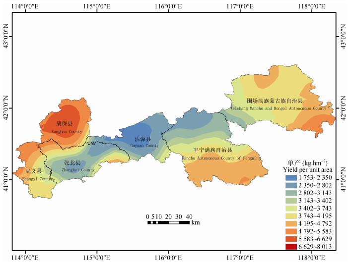
图1坝上地区粮食单产分布图
Figure1.Distribution pattern of grain yield in Bashang area
 下载: 全尺寸图片幻灯片
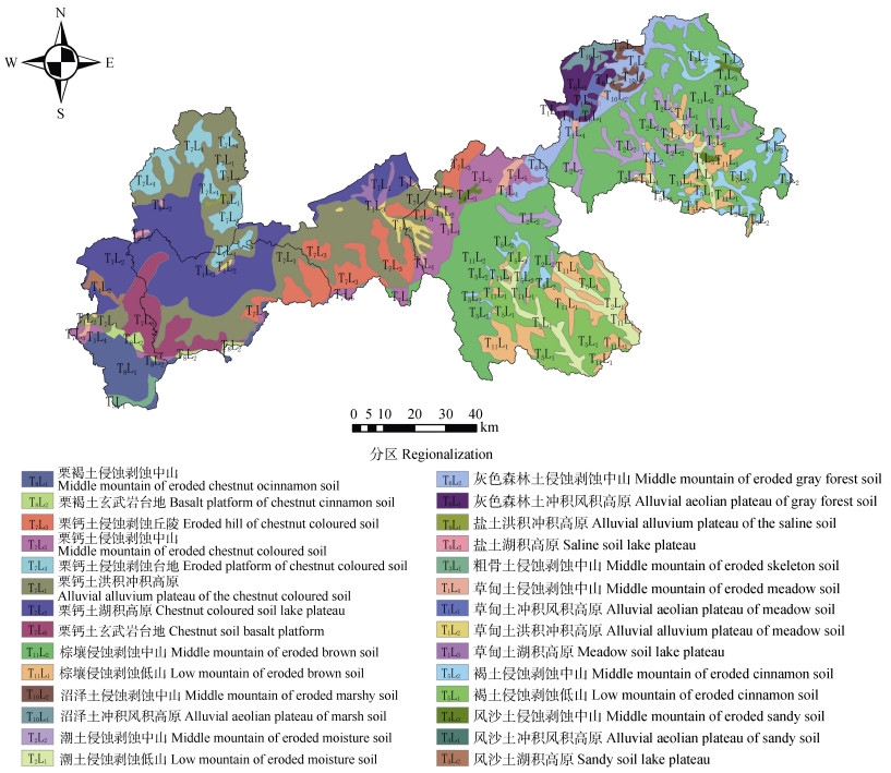
图2坝上地区土地生态要素类型分区图
Figure2.Zoning map of land ecological factors in Bashang area
下载: 全尺寸图片幻灯片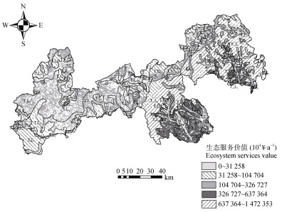
图32015年坝上生态用地生态服务价值分布图
Figure3.Ecological service value distribution of ecological land in Bashang area in 2015
下载: 全尺寸图片幻灯片表1坝上地区生态用地统一分类体系
Table1.Unified classification system of ecological land in Bashang area
| 一级类 First class | 二级类 Second class | ||||
| 编码 Code | 名称 Name | 编码 Code | 名称 Name | 含义 Illustration | |
| 1 | 草地 Grassland | 11 | 草甸草地 Meadow grassland | 覆盖度 > 30%, 以草本植物为主的各类草地 Herbaceous plant grassland with > 30% coverage rate | |
| 12 | 典型草地 Typical grassland | 覆盖度在10%~30%, 以旱生草本为主的草地 Herbaceous plant grassland with 10%-30% coverage rate | |||
| 13 | 荒漠草地 Desert grassland | 覆盖度在5%~10%, 以强旱生植物为主的草地 Xerophyte grassland with 5%-10% coverage rate | |||
| 14 | 灌丛草地 Shrub land | 草地中灌丛覆盖度 < 40%, 灌丛高度 < 2 m Grassland with shrub coverage < 40% and height < 2 m | |||
| 2 | 林地 Forest | 21 | 常绿针叶林 Evergreen coniferous forest | 郁闭度 > 30%, 高度 > 2 m的常绿针叶林 Evergreen coniferous forest with canopy density > 30%, height > 2 m | |
| 22 | 常绿阔叶林 Evergreen broadleaf forest | 郁闭度 > 30%, 高度 > 2 m的常绿阔叶林 Evergreen broadleaf forest with canopy density > 30%, height > 2 m | |||
| 23 | 落叶针叶林 Deciduous coniferous forest | 郁闭度 > 30%, 高度 > 2 m的落叶针叶林 Deciduous coniferous forest with canopy density > 30%, height > 2 m | |||
| 24 | 落叶阔叶林 Deciduous broadleaf forest | 郁闭度 > 30%, 高度 > 2 m的落叶阔叶林 Deciduous broadleaf forest with canopy density > 30%, height > 2 m | |||
| 25 | 针阔混交林 Mixed broadleaf-conifer forest | 郁闭度 > 30%, 高度 > 2 m的针阔混交林 Mixed broadleaf-conifer forest with canopy density > 30%, height > 2 m | |||
| 26 | 灌丛 Shrub | 郁密度 > 40%, 高度 > 2 m的灌丛和矮林 Shrub and copse with canopy density > 40%, height > 2 m | |||
| 3 | 湿地 Wetland | 31 | 内陆水体Inland water | 陆地上各种淡水湖、咸水湖、水库及坑塘、河流 Freshwater lake, salt lake, reservoir, pond and rive | |
| 32 | 河湖滩地 River beach | 河流沿岸或湖泊周边的滩地, 包括边滩、心滩等 Beaches of river and lake | |||
| 33 | 沼泽地 Marsh land | 植被覆盖度高的湿生草地, 地势平坦低洼、排水不畅、长期积水且表层生长湿生草本植被的土地 Wet grassland with high vegetation coverage, wetland with herbs | |||
| 34 | 永久性冰川雪地 Permanent glacier and firn | 常年被冰川和积雪所覆盖的土地 Glacier and snow covered land | |||
| 4 | 其他生态用地 Other ecological land | 41 | 盐碱地 Saline land | 地表盐碱聚集, 植被稀少, 只能生长强耐盐碱植物的土地 Vegetation is sparse and salt accumulation in surface soil. | |
| 42 | 裸岩 Bare rock | 地表以岩石或石砾为主、植被覆盖度在5%以下的荒漠及戈壁、裸露石山等无植被地段 Desert, gobi and rock mountain with < 5% vegetation coverage rate | |||
| 43 | 裸地 Bare land | 地表为土质、植被覆盖度在5%以下的裸土地等无植被地段 Bare soil with < 5% vegetation coverage rate | |||
| 44 | 沙地 Sandy land | 植被覆盖度在5%以下的沙地、流动沙丘 Sandy land and active sand dune with vegetation coverage rate < 5% | |||
下载: 导出CSV表2坝上各土地生态要素类型区的特征及粮食单产情况
Table2.Characteristics and grain yield per unit area of each region of land ecological elements in Bashang area
| 类型区 Region | 粮食单产 Grain yield (kg·hm-2) | 特征 Characteristics |
| 草甸土冲积风积高原 Alluvial aeolian plateau of meadow soil | 3 326 | 土层深厚; 土壤呈微酸性, 较为肥沃, 有机质含量较高, 水分状况较好, 疏松多孔; 植被覆盖度 > 70%。 Soil is weakly acid and porous with deep layer, higher organic matter content and sufficient water. The vegetation coverage rate is higher than 70%. |
| 草甸土洪积冲积高原 Alluvial alluvium plateau of meadow soil | 2 597 | 耕层砂壤土, 通透性良好, 有机质含量较高; 耕层以下以砂土为主。土壤季节性干湿变化。垦殖时间短, 土壤质地轻, 有机质分解转化缓慢, 速效养分含量低。 Plough layer soil is sandy loam with higher organic matter, while soil under plough layer is sandy soil. Soil is in seasonal alterations of drying and wetting. Available nutrients contents of soil are lower. Decomposition and transformation of organic matter are slow. Soil texture is light due to short exploitation time. |
| 草甸土湖积高原 Meadow soil lake plateau | 2 948 | 土层深厚, 有较好的团粒结构, 疏松多孔, 质地均一, 通体壤质, 土体构型良好。土壤水分长期处于饱和状态, 地温低, 不宜垦殖为农田。 Soil is loamy with deeper layer and granular structure. Soil water is saturated and temperature is lower, and is not suitable for farming. |
| 草甸土侵蚀剥蚀中山 Middle mountain of eroded meadow soil | 3 358 | 地势微倾斜, 无季节性积水, 植被覆盖度60%~70%。土壤肥沃, 土层深厚; 地下水位较高但不易沥涝, 土壤水分较充沛; 气候寒冷, 无霜期短, 积温不足, 不宜垦殖为农用。 Terrain is micro tilt, and there is no seasonal waterlogging. The vegetation coverage rate is 60%-70%. Soil is fertile and soil layer is deep. Soil water is abundant and groundwater table is higher. Climate is cool with short frost-free duration and insufficient accumulated temperature, not suitable for farming. |
| 潮土侵蚀剥蚀低山 Low mountain of eroded moisture soil | 4 339 | 耕层为壤土, 屑粒状结构, 疏松, 多空隙, 水分状况较好, 养分含量较高; 但大部分土层较薄。 Plough layer is shallow, soil is loamy soil with granular structure, high porosity, well water condition and high nutrients content. |
| 潮土侵蚀剥蚀中山 Middle mountain of eroded moisture soil | 3 785 | 土壤质地偏粗, 屑粒结构, 疏松, 多孔隙, 通透性好。耕性好, 宜耕期长, 但该土壤保水保肥能力差, 干旱, 土壤潜在养分低。 Soil texture is coarse and granular with good permeability. Soil is suitable for long term farming, but is lower in water and fertility conservation, and usually is dry with lower potential nutrient. |
| 粗骨土侵蚀剥蚀中山 Middle mountain of eroded skeleton soil | 2 471 | 土层薄, 砾石含量多, 坡度大; 土壤侵蚀严重, 自然植被稀少; 剖面发育不完全; 土壤养分贫乏, 保水保肥性能差。 Slope is high. Soil layer is shallow and deficient in nutrients with higher cobble content and serious erosion. |
| 风沙土冲积风积高原 Alluvial aeolian plateau of sandy soil | 3 042 | 土层深厚, 但通体土少石多, 为砂砾土, 养分含量较低, 且保水保肥能力极差, 植被很少。 Sandy soil layer is deep with lower nutrients content, lower water and fertility conservation, and rarely vegetation. |
| 风沙土湖积高原 Sandy soil lake plateau | 3 374 | 土壤通体为砂壤土, 疏松, 肥力瘠薄, 养分含量低, 保水保肥性能差。 Soil is sandy loam with lower nutrients content and water and fertility conservation. |
| 风沙土侵蚀剥蚀中山 Middle mountain of eroded sandy soil | 3 824 | 土壤通体为砂土, 成土时间短, 土壤剖面特征发育微弱, 植被覆盖度可达30%左右。 Soil is sand. Soil profile development is weak due to short soil forming time. The vegetation coverage rate is about 30%. |
| 褐土侵蚀剥蚀低山 Low mountain of eroded cinnamon soil | 6 573 | 土层薄, 表层质地为砂黏壤土, 土壤疏松, 结构良好, 质地适中, 有机质含量丰富, 植被覆盖率较高, 具有较强的保水保肥性能。水热状况较好, 土壤酸碱度适宜, 立地条件优越。 Soil layer is shallow. Surface soil is sandy clay loam. Soil is in good structure and proper texture with sufficient organic matter, strong water and fertility conservation ability, good water and heat condition, suitable pH. Vegetation coverage rate is higher. |
| 褐土侵蚀剥蚀中山 Middle mountain of eroded cinnamon soil | 5 361 | 土层薄, 有机质含量丰富, 土壤疏松, 结构良好, 质地适中; 植被覆盖率较高, 具有较强的保水保肥性能。地形多为较陡的山坡或岗坡, 易发生水土流失。 Soil layer is shallow and in good structure and proper texture with sufficient organic matter, strong water and fertility conservation ability. Vegetation coverage rate is higher. Due to the terrain is usually steep slope, soil and water erosion is prone to happen. |
| 灰色森林土冲积风积高原 Alluvial aeolian plateau of gray forest soil | 3 072 | 质地为砂壤土, 地形起伏, 内外排水性能好, 极易形成干旱现象, 大部分实行草田轮作。易发生风蚀和水蚀现象, 土壤全量养分丰富, 速效养分不足。 Soil texture is sandy loam with good drainage ability and prone to be dry. Terrain is relief. Wind and water erosion is prone to be happen. Available nutrients contents are lower though the total nutrients contents are higher. |
| 灰色森林土侵蚀剥蚀中山 Middle mountain of eroded gray forest soil | 3 495 | 土壤通体为砂壤土, 质地适中, 疏松多孔, 呈微酸性, 有较好的团粒结构, 养分含量高, 土层较厚, 吸热能量大。 Sandy loam soil is weak acid with proper texture, good granular structure, high nutrients contents, deep soil layer and good heat condition. |
| 栗钙土洪积冲积高原 Alluvial alluvium plateau of the chestnut coloured soil | 3 282 | 成土母质为洪冲积物, 海拔1 400 m左右, 气候寒温干旱、多风。土层深厚, 质地均一, 耕性良好, 土壤潜在肥力较高, 但土壤风蚀严重, 蓄水保墒能力差, 水分不足。 Parent material is diluvial deposit. The altitude is around 1 400 m with cold, arid and windy climate. Soil layer is deep and texture is even. Soil potential fertility is higher and suitable for farming. But, because of serious wind erosion, the water conservation ability of soil is weak. |
| 栗钙土湖积高原 Chestnut coloured soil lake plateau | 3 677 | 气候寒温干旱, 春季多风, 风蚀较重。表土多为砂黏壤土, 有效养分含量低, 极度缺磷, 水分不足, 土体中有“钙积”障碍层。 Climate is cold and arid, windy in spring with serious wind erosion. Surface soil is sandy clay loam with lower available nutrients, especially phosphorus is extremely deficient. There is caleie horizon in soil profile and soil water content is lower. |
| 栗钙土侵蚀剥蚀丘陵 Eroded hill of chestnut coloured soil | 4 275 | 地势平缓, 土层深厚, 疏松多孔, 土壤水分、养分含量较高, 保水保肥性能较好。但因寒温半湿润条件的影响, 植物生长比较繁茂, 植物残体较多, 气温低, 微生物活动差。 Topography is gentle, soil layer is deep and porous with sufficient water and nutrients, and higher in water and fertility conservation ability. Though vegetation grows well, microorganism activity is lower due to lower temperature. |
| 栗钙土侵蚀剥蚀台地 Eroded platform of chestnut coloured soil | 3 841 | 表土质地一般为砂壤土, 土层厚度平均值为90 cm。海拔较高, 气候湿润。耕性良好, 但土壤代换量低, 保肥性能差。土壤养分含量较低, 易发生水土流失。 Surface soil is sandy loam, and average soil layer depth is 90 cm. Altitude is high, and climate is humid. Though soil is suitable for farming, it contains less nutrients and prone to water and soil loss. |
| 栗钙土侵蚀剥蚀中山 Middle mountain of eroded chestnut coloured soil | 3 713 | 土层深厚, 质地适中, 土壤潜在肥力高, 保肥性能好, 年降水量相对较多, 土壤水含量较高, 耕性良好。但水土流失严重, 土壤缺磷, 少锌。 Soil depth is deep with proper texture, high potential fertility and high fertility conservation ability, but soil is insufficient in phosphorus and zinc. Annual rainfall is high. Soil is suitable for farming with high water content. |
| 栗钙土玄武岩台地 Basalt platform of chestnut cinnamon soil | 2 320 | 土壤表层有机质、全氮、碱解氮及钾含量高。屑粒状结构, 土体紧实少孔, 根系较多, 无石灰反应。坡度大, 土层薄, 易受侵蚀, 水分不足, 保水保肥性能差。 Surface soil contents of organic matter, total nitrogen, available nitrogen and potassium are high. The soil structure is granular, soil is compact with many plants roots. No lime reaction is observed. Due to large slope gradient and shallow soil layer, soil erosion is liable occur, and water and fertility conservation ability is low. |
| 栗褐土侵蚀剥蚀中山 Middle mountain of eroded chestnut cinnamon soil | 3 468 | 土层深厚, 质地适中, 石灰反应强烈, 但土壤干旱, 养分含量贫缺。植被覆盖度低, 土壤侵蚀严重。 Soil layer is deep with proper texture and strong lime reaction. Soil is dry with low nutrient content. Vegetation coverage rate is low and soil erosion is serious. |
| 栗褐土玄武岩台地 Basalt platform of chestnut cinnamon soil | 2 748 | 有机质含量低, 植被稀疏, 水土流失严重。中玄武岩喷溢而形成的台地, 上覆黄砂土, 十分贫瘠, 可为林业用地。 Soil organic matter content is low with serious soil and water erosion. Vegetation is sparse. Topography is platform formed by the eruption of basalt with barren sandy loess surface soil. The land may be used for forest. |
| 盐土洪积冲积高原 Alluvial alluvium plateau of the saline soil | 3 107 | 土壤质地以壤质为主, 土壤表层含盐量高于心土和底土层, 土体全盐含量呈上低下高的梯形分布。表土光滑较硬, 有机质含量变化大, 植被覆盖度较高。 Soil texture is loamy, and surface soil contains more salt than subsoil and undersoil. Surface soil is smooth and hard with high organic matter content. Vegetation coverage rate is high. |
| 盐土湖积高原 Saline soil lake plateau | 2 562 | 质地以粉砂土为主, 土色灰暗。土壤质地黏重, 物理性状不良, 难以种植利用。雨季地表径流汇集, 土壤含盐量高, 一般植物不能生长。 Soil texture is silt with poor physical properties and not suitable for farming. Soil salt content is high. |
| 沼泽土冲积风积高原 Alluvial aeolian plateau of marsh soil | 3 722 | 表耕层团粒状结构, 疏松多孔, 植物根密集。所处地形较高, 一般雨季为积水期, 土体中水分饱和, 黏重闭气, 耕性较差, 土性湿冷。 Plough layer soil is in granular structure and porous with dense plants roots. Soil is clamminess, glutinous and not suitable for farming. |
| 沼泽土侵蚀剥蚀中山 Middle mountain of eroded marshy soil | 4 317 | 通体砂壤, 石灰反应微弱, 表耕层屑粒状结构, 疏松多孔, 植物根盘结。土质地粗, 水分过多, 通透性差, 耕性好, 肥力较高。 Soil is sandy loam with weak lime reaction. Plough layer soil is in granular structure and porous with dense plants roots. Soil texture is coarse and moisture with lower permeability. Soil fertility is high and suitable for farming. |
| 棕壤侵蚀剥蚀低山 Low mountain of eroded brown soil | 4 695 | 土壤水分特点:表湿下润, 中度淋溶。土层深厚, 团粒结构, 表层紧实, 粘化不明显, 除速效磷外其他养分较为丰富。 Soil is wet in surface and humid in subsoil with medium leakage. Soil layer is deep with granular structure. Surface soil is compact. Soil nutrients are sufficient except phosphorus. |
| 棕壤侵蚀剥蚀中山 Middle mountain of eroded brown soil | 3 419 | 土层深厚, 一般大于1 m, 质地偏砂, 土壤有机质矿化快, 积累少, 肥力低。易缺水干旱, 缺氮, 缺磷。气候特点:中温, 湿润, 冷凉。土壤通体无石灰反应。 Soil depth is deeper than 1 m. Soil texture is sandy with lower fertility, insufficient nitrogen and phosphors. Climate is temperature, humid. |
下载: 导出CSV表32015年坝上各土地生态要素类型区的生态用地面积统计表
Table3.Statistics of ecological land areas of each region of land ecological elements in Bashang area in 2015
| 类型区 Region | 草地 Grassland | 林地 Forest | 湿地 Wetland | 其他生态用地 Other ecological land | 非生态用地 Non ecological land | 生态用地面积占比 Proportion of ecological land area(%) | 总计 Total (hm2) | |||||||||
| 面积 Area (hm2) | 比例 Percent (%) | 面积 Area (hm2) | 比例 Percent (%) | 面积 Area (hm2) | 比例 Percent (%) | 面积 Area (hm2) | 比例 Percent (%) | 面积 Area (hm2) | 比例 Percent (%) | |||||||
| 草甸土冲积风积高原 Alluvial aeolian plateau of meadow soil | 7 464.63 | 1.06 | 4 316.95 | 0.26 | 134.25 | 0.61 | 0.00 | 0.00 | 798.48 | 0.10 | 93.72 | 12 714.32 | ||||
| 草甸土洪积冲积高原 Alluvial alluvium plateau of meadow soil | 12 103.40 | 1.72 | 5 056.79 | 0.31 | 305.46 | 1.39 | 0.00 | 0.00 | 11 358.28 | 1.47 | 60.59 | 28 823.92 | ||||
| 草甸土湖积高原 Meadow soil lake plateau | 9 375.04 | 1.33 | 2 235.70 | 0.14 | 1 350.12 | 6.13 | 196.94 | 0.62 | 4 960.88 | 0.64 | 72.62 | 18 118.67 | ||||
| 草甸土侵蚀剥蚀中山 Middle mountain of eroded meadow soil | 8 471.84 | 1.20 | 6 777.58 | 0.41 | 0.00 | 0.00 | 0.00 | 0.00 | 1 969.75 | 0.25 | 88.56 | 17 219.17 | ||||
| 潮土侵蚀剥蚀低山 Low mountain of eroded | 17 392.48 | 2.47 | 57 057.66 | 3.48 | 740.48 | 3.36 | 648.26 | 2.06 | 26 750.95 | 3.46 | 73.92 | 102 589.82 | ||||
| 潮土侵蚀剥蚀中山 Middle mountain of eroded moisture soil | 4 573.21 | 0.65 | 60 834.07 | 3.71 | 600.21 | 2.73 | 203.45 | 0.65 | 26 059.91 | 3.37 | 71.76 | 92 270.85 | ||||
| 粗骨土侵蚀剥蚀中山 Middle mountain of eroded skeleton soil | 8 087.31 | 1.15 | 3 385.81 | 0.21 | 0.00 | 0.00 | 0.00 | 0.00 | 1 180.92 | 0.15 | 90.67 | 12 654.04 | ||||
| 风沙土冲积风积高原 Alluvial aeolian plateau of sandy soil | 1 177.28 | 0.17 | 1 152.38 | 0.07 | 0.00 | 0.00 | 0.00 | 0.00 | 364.05 | 0.05 | 86.49 | 2 693.71 | ||||
| 风沙土湖积高原 Sandy soil lake plateau | 1 922.23 | 0.27 | 3 970.69 | 0.24 | 0.00 | 0.00 | 0.00 | 0.00 | 4 736.32 | 0.61 | 55.44 | 10 629.23 | ||||
| 风沙土侵蚀剥蚀中山 Middle mountain of eroded sandy soil | 3 872.73 | 0.55 | 5 307.33 | 0.32 | 0.00 | 0.00 | 0.00 | 0.00 | 2 608.36 | 0.34 | 77.87 | 11 788.43 | ||||
| 褐土侵蚀剥蚀低山 Low mountain of eroded cinnamon soil | 29 783.44 | 4.22 | 131 621.04 | 8.02 | 257.29 | 1.17 | 1 010.57 | 3.21 | 21 013.98 | 2.72 | 88.56 | 183 686.33 | ||||
| 褐土侵蚀剥蚀中山 Middle mountain of eroded cinnamon soil | 9 212.81 | 1.31 | 56 491.35 | 3.44 | 91.04 | 0.41 | 835.38 | 2.65 | 24 244.35 | 3.14 | 73.32 | 90 874.94 | ||||
| 灰色森林土冲积风积高原 Alluvial aeolian plateau of gray forest soil | 26 205.55 | 3.72 | 21 798.60 | 1.33 | 450.64 | 2.05 | 0.00 | 0.00 | 2 141.57 | 0.28 | 95.77 | 50 596.37 | ||||
| 灰色森林土侵蚀剥蚀中山 Middle mountain of eroded gray forest soil | 40 705.96 | 5.77 | 76 785.78 | 4.68 | 1 984.08 | 9.01 | 0.00 | 0.00 | 3 493.00 | 0.45 | 97.16 | 122 968.81 | ||||
| 栗钙土洪积冲积高原 Alluvial alluvium plateau of the chestnut coloured soil | 118 032.96 | 16.74 | 135 128.73 | 8.23 | 2 015.90 | 9.16 | 2 565.95 | 8.14 | 195 476.51 | 25.28 | 56.87 | 453 220.04 | ||||
| 栗钙土湖积高原 Chestnut coloured soil lake plateau | 98 789.68 | 14.01 | 106 378.36 | 6.48 | 11 663.59 | 52.99 | 18 963.66 | 60.14 | 173 751.39 | 22.47 | 57.57 | 409 546.68 | ||||
| 栗钙土侵蚀剥蚀丘陵 The eroded hill of chestnut coloured soil | 36 652.59 | 5.20 | 56 219.99 | 3.42 | 239.21 | 1.09 | 749.72 | 2.38 | 61 716.70 | 7.98 | 60.33 | 155 578.21 | ||||
| 栗钙土侵蚀剥蚀台地 Eroded platform of chestnut coloured soil | 39 566.41 | 5.61 | 28 931.69 | 1.76 | 168.53 | 0.77 | 244.68 | 0.78 | 38 595.82 | 4.99 | 64.10 | 107 507.13 | ||||
| 栗钙土侵蚀剥蚀中山 Middle mountain of eroded chestnut coloured soil | 58 287.84 | 8.27 | 53 896.32 | 3.28 | 0.00 | 0.00 | 0.00 | 0.00 | 18 994.42 | 2.46 | 85.52 | 131 178.57 | ||||
| 栗钙土玄武岩台地 The eroded platform of chestnut coloured soil | 15 359.57 | 2.18 | 39 286.77 | 2.39 | 167.61 | 0.76 | 878.68 | 2.79 | 45 663.36 | 5.91 | 54.95 | 101 355.99 | ||||
| 栗褐土侵蚀剥蚀中山 Middle mountain of eroded chestnut cinnamon soil | 46 905.07 | 6.65 | 33 870.95 | 2.06 | 0.00 | 0.00 | 0.00 | 0.00 | 13 359.27 | 1.73 | 85.81 | 94 135.29 | ||||
| 栗褐土玄武岩台地 Basalt platform of chestnut cinnamon soil | 4 295.77 | 0.61 | 5 876.95 | 0.36 | 0.00 | 0.00 | 0.00 | 0.00 | 5 426.02 | 0.70 | 65.21 | 15 598.73 | ||||
| 盐土洪积冲积高原 Aluvial alluvium plateau of the saline soil | 854.29 | 0.12 | 1 003.79 | 0.06 | 185.65 | 0.84 | 1.12 | 0.00 | 1 415.99 | 0.18 | 59.09 | 3 460.84 | ||||
| 盐土湖积高原 The saline soil lake plateau | 1 028.32 | 0.15 | 0.16 | 0.00 | 0.00 | 0.00 | 2.14 | 0.01 | 1 563.03 | 0.20 | 39.74 | 2 593.66 | ||||
| 沼泽土冲积风积高原 The alluvial aeolian plateau of marsh soil | 4 482.22 | 0.64 | 14 670.93 | 0.89 | 470.38 | 2.14 | 140.97 | 0.45 | 191.14 | 0.02 | 99.04 | 19 955.64 | ||||
| 沼泽土侵蚀剥蚀中山 The middle mountain of eroded marshy soil | 6 324.40 | 0.90 | 9 386.93 | 0.57 | 1 147.28 | 5.21 | 0.00 | 0.00 | 58.25 | 0.01 | 99.66 | 16 916.86 | ||||
| 棕壤侵蚀剥蚀低山 The low mountain of eroded brown soil | 15 380.58 | 2.18 | 135 648.17 | 8.26 | 0.76 | 0.00 | 667.86 | 2.12 | 13 354.87 | 1.73 | 91.91 | 165 052.24 | ||||
| 棕壤侵蚀剥蚀中山 The middle mountain of eroded brown soil | 78 870.90 | 11.18 | 584 539.73 | 35.61 | 38.51 | 0.17 | 4 420.83 | 14.02 | 72 007.11 | 9.31 | 90.27 | 739 877.07 | ||||
| 总计 Total | 705 178.50 | 22.22 | 1 641 631.20 | 51.73 | 22 010.98 | 0.69 | 31 530.21 | 0.99 | 773 254.68 | 24.37 | 75.63 | 3 173 605.56 | ||||
下载: 导出CSV表42015年坝上各土地生态要素类型区生态用地的生态系统服务价值统计表
Table4.Ecosystem service values for the ecological land of each region of land ecological elements in Bashang area in 2015
| 类型区Region | 草地 Grassland | 林地 Forest | 湿地 Wetland | 其他生态用地 Other ecological land | 总计Total | |
| 草甸土冲积风积高原 Alluvial aeolian plateau of meadow soil | Eij (¥·hm-2·a-1) | 12 914.38 | 24 503.12 | 143 907.71 | 491.77 | — |
| ESV (104¥·a-1) | 9 640.11 | 10 577.88 | 1 932.00 | 0.00 | 22 149.99 | |
| 草甸土洪积冲积高原 Alluvial alluvium plateau of meadow soil | Eij (¥·hm-2·a-1) | 10 083.78 | 19 132.47 | 112 365.70 | 383.99 | — |
| ESV (104¥·a-1) | 12 204.80 | 9 674.88 | 3 432.28 | 0.00 | 25 311.96 | |
| 草甸土湖积高原 Meadow soil lake plateau | Eij (¥·hm-2·a-1) | 11 446.66 | 21 718.34 | 127 552.59 | 435.88 | — |
| ESV (104¥·a-1) | 10 731.29 | 4 855.58 | 17 221.07 | 8.58 | 32 816.52 | |
| 草甸土侵蚀剥蚀中山 Middle mountain of eroded meadow soil | Eij (¥·hm-2·a-1) | 13 038.63 | 24 738.87 | 145 292.27 | 496.50 | — |
| ESV (104¥·a-1) | 11 046.13 | 16 766.96 | 0.00 | 0.00 | 27 813.09 | |
| 潮土侵蚀剥蚀低山 Low mountain of eroded moisture soil | Eij (¥·hm-2·a-1) | 16 847.72 | 31 966.03 | 187 737.68 | 641.55 | — |
| ESV (104¥·a-1) | 29 302.36 | 182 390.69 | 13 901.57 | 41.59 | 225 636.21 | |
| 潮土侵蚀剥蚀中山 Middle mountain of eroded moisture soil | Eij (¥·hm-2·a-1) | 14 696.61 | 27 884.64 | 163 767.49 | 559.64 | — |
| ESV (104¥·a-1) | 6 721.07 | 169 633.58 | 9 829.54 | 11.39 | 186 195.57 | |
| 粗骨土侵蚀剥蚀中山 Middle mountain of eroded skeleton soil | Eij (¥·hm-2·a-1) | 9 594.54 | 18 204.21 | 106 913.99 | 365.36 | — |
| ESV (104¥·a-1) | 7 759.40 | 6 163.59 | 0.00 | 0.00 | 13 923.00 | |
| 风沙土冲积风积高原 Alluvial aeolian plateau of sandy soil | Eij (¥·hm-2·a-1) | 11 811.65 | 22 410.85 | 131 619.74 | 449.78 | — |
| ESV (104¥·a-1) | 1 390.56 | 2 582.58 | 0.00 | 0.00 | 3 973.14 | |
| 风沙土湖积高原 Sandy soil lake plateau | Eij (¥·hm-2·a-1) | 13 100.76 | 24 856.74 | 145 984.55 | 498.87 | — |
| ESV (104¥·a-1) | 2 518.26 | 9 869.85 | 0.00 | 0.00 | 12 388.11 | |
| 风沙土侵蚀剥蚀中山 Middle mountain of eroded sandy soil | Eij (¥·hm-2·a-1) | 14 848.05 | 28 171.95 | 165 454.92 | 565.41 | — |
| ESV (104¥·a-1) | 5 750.25 | 14 951.79 | 0.00 | 0.00 | 20 702.04 | |
| 褐土侵蚀剥蚀低山 Low mountain of eroded cinnamon soil | Eij (¥·hm-2·a-1) | 25 522.02 | 48 424.23 | 284 397.28 | 971.87 | — |
| ESV (104¥·a-1) | 76 013.36 | 637 364.77 | 7 317.33 | 98.21 | 720 793.67 | |
| 褐土侵蚀剥蚀中山 Middle mountain of eroded cinnamon soil | Eij (¥·hm-2·a-1) | 20 816.00 | 39 495.25 | 231 957.07 | 792.66 | — |
| ESV (104¥·a-1) | 19 177.39 | 223 114.02 | 2 111.81 | 66.22 | 244 469.44 | |
| 灰色森林土冲积风积高原 Alluvial aeolian plateau of gray forest soil | Eij (¥·hm-2·a-1) | 11 928.14 | 22 631.86 | 132 917.76 | 454.22 | — |
| ESV (104¥·a-1) | 31 258.34 | 49 334.30 | 5 989.87 | 0.00 | 86 582.51 | |
| 灰色森林土侵蚀剥蚀中山 Middle mountain of eroded gray forest soil | Eij (¥·hm-2·a-1) | 13 570.59 | 25 748.16 | 151 219.91 | 516.76 | — |
| ESV (104¥·a-1) | 55 240.37 | 197 709.29 | 30 003.19 | 0.00 | 282 952.85 | |
| 栗钙土洪积冲积高原 Alluvial alluvium plateau of the chestnut coloured soil | Eij (¥·hm-2·a-1) | 12 743.54 | 24 178.96 | 142 003.94 | 485.27 | — |
| ESV (104¥·a-1) | 150 415.74 | 326 727.25 | 28 626.52 | 124.52 | 505 894.03 | |
| 栗钙土湖积高原 Chestnut coloured soil lake plateau | Eij (¥·hm-2·a-1) | 14 277.27 | 27 088.98 | 159 094.60 | 543.67 | — |
| ESV (104¥·a-1) | 141 044.65 | 288 168.17 | 185 561.34 | 1 031.00 | 615 805.16 | |
| 栗钙土侵蚀剥蚀丘陵 Eroded hill of chestnut coloured soil | Eij (¥·hm-2·a-1) | 16 599.21 | 31 494.54 | 184 968.56 | 632.09 | — |
| ESV (104¥·a-1) | 60 840.41 | 177 062.26 | 4 424.63 | 47.39 | 242 374.69 | |
| 栗钙土侵蚀剥蚀台地 Eroded platform of chestnut coloured soil | Eij (¥·hm-2·a-1) | 14 914.05 | 28 297.20 | 166 190.47 | 567.92 | — |
| ESV (104¥·a-1) | 59 009.56 | 81 868.57 | 2 800.78 | 13.90 | 143 692.80 | |
| 栗钙土侵蚀剥蚀中山 Middle mountain of eroded chestnut coloured soil | Eij (¥·hm-2·a-1) | 14 417.05 | 27 354.20 | 160 652.23 | 548.99 | — |
| ESV (104¥·a-1) | 84 033.86 | 147 429.07 | 0.00 | 0.00 | 231 462.93 | |
| 栗钙土玄武岩台地 Chestnut soil basalt platform | Eij (¥·hm-2·a-1) | 9 008.23 | 17 091.77 | 100 380.60 | 343.03 | — |
| ESV (104¥·a-1) | 13 836.25 | 67 148.05 | 1 682.43 | 30.14 | 82 696.88 | |
| 栗褐土侵蚀剥蚀中山 Middle mountain of eroded chestnut cinnamon soil | Eij (¥·hm-2·a-1) | 13 465.75 | 25 549.25 | 150 051.69 | 512.77 | — |
| ESV (104¥·a-1) | 63 161.19 | 86 537.74 | 0.00 | 0.00 | 149 698.94 | |
| 栗褐土玄武岩台地 Basalt platform of chestnut cinnamon soil | Eij (¥·hm-2·a-1) | 10 670.09 | 20 244.91 | 118 899.09 | 406.31 | — |
| ESV (104¥·a-1) | 4 583.62 | 11 897.82 | 0.00 | 0.00 | 16 481.45 | |
| 盐土洪积冲积高原 Alluvial alluvium plateau of the saline soil | Eij (¥·hm-2·a-1) | 12 064.04 | 22 889.71 | 134 432.12 | 459.39 | — |
| ESV (104¥·a-1) | 1 030.62 | 2 297.64 | 2 495.76 | 0.05 | 5 824.07 | |
| 盐土湖积高原 Saline soil lake plateau | Eij (¥·hm-2·a-1) | 9 947.88 | 18 874.62 | 110 851.34 | 378.81 | — |
| ESV (104¥·a-1) | 1 022.96 | 0.31 | 0.00 | 0.08 | 1 023.35 | |
| 沼泽土冲积风积高原 Alluvial aeolian plateau of marsh soil | Eij (¥·hm-2·a-1) | 14 451.99 | 27 420.51 | 161 041.64 | 550.32 | — |
| ESV (104¥·a-1) | 6 477.71 | 40 228.42 | 7 575.06 | 7.76 | 54 288.95 | |
| 沼泽土侵蚀剥蚀中山 Middle mountain of eroded marshy soil | Eij (¥·hm-2·a-1) | 16 762.29 | 31 803.96 | 186 785.80 | 638.30 | — |
| ESV (104¥·a-1) | 10 601.15 | 29 854.14 | 21 429.61 | 0.00 | 61 884.90 | |
| 棕壤侵蚀剥蚀低山 Low mountain of eroded brown soil | Eij (¥·hm-2·a-1) | 18 230.01 | 34 588.74 | 203 140.91 | 694.19 | — |
| ESV (104¥·a-1) | 28 038.82 | 469 189.86 | 15.45 | 46.36 | 497 290.49 | |
| 棕壤侵蚀剥蚀中山 Middle mountain of eroded brown soil | Eij (¥·hm-2·a-1) | 13 275.49 | 25 188.26 | 147 931.58 | 505.52 | — |
| ESV (104¥·a-1) | 104 704.97 | 1 472 353.96 | 569.61 | 223.48 | 1 577 852.02 | |
| ESV总计Total | ESV (108¥·a-1) | 100.76 | 473.58 | 34.69 | 0.18 | 609.20 |
| Eij:生态系统服务价值单价; ESV:生态系统服务价值。Eij: ecosystem service value per unit area; ESV: ecosystem service value of the region. | ||||||
下载: 导出CSV参考文献
| [1] | 邓红兵, 陈春娣, 刘昕, 等.区域生态用地的概念及分类[J].生态学报, 2009, 29(3):1519-1524 http://med.wanfangdata.com.cn/Paper/Detail/PeriodicalPaper_stxb200903050 DENG H B, CHEN C D, LIU X, et al. Conception and func-tion classification of regional ecological land[J]. Acta Eco-logica Sinica, 2009, 29(3):1519-1524 http://med.wanfangdata.com.cn/Paper/Detail/PeriodicalPaper_stxb200903050 |
| [2] | 喻锋, 李晓波, 张丽君, 等.中国生态用地研究:内涵、分类与时空格局[J].生态学报, 2015, 35(14):4931-4943 http://www.ecologica.cn/stxb/ch/html/2015/14/stxb201311052672.htm YU F, LI X B, ZHANG L J, et al. Study of ecological land in China:Conception, classification, and spatial-temporal pat-tern[J]. Acta Ecologica Sinica, 2015, 35(14):4931-4943 http://www.ecologica.cn/stxb/ch/html/2015/14/stxb201311052672.htm |
| [3] | 周朕, 蒙吉军, 齐杨, 等.中国生态用地重要性及其格局优化研究进展[J].生态学杂志, 2016, 35(1):218-225 http://www.cqvip.com/QK/90811X/201601/667691626.html ZHOU Z, MENG J J, QI Y, et al. Importance of ecological lands and their pattern optimization in China:A review[J]. Chinese Journal of Ecology, 2016, 35(1):218-225 http://www.cqvip.com/QK/90811X/201601/667691626.html |
| [4] | 符蓉, 喻锋, 于海跃.国内外生态用地理论研究与实践探索[J].国土资源情报, 2014, (2):32-36 http://www.wanfangdata.com.cn/details/detail.do?_type=perio&id=gtzyqb201402007 FU R, YU F, YU H Y. Theory research and practical exploration of ecological land both at home and abroad[J]. Land and Resources Information, 2014, (2):32-36 http://www.wanfangdata.com.cn/details/detail.do?_type=perio&id=gtzyqb201402007 |
| [5] | 欧阳志云, 李小马, 徐卫华, 等.北京市生态用地规划与管理对策[J].生态学报, 2015, 35(11):3778-3787 http://med.wanfangdata.com.cn/Paper/Detail/PeriodicalPaper_stxb201511030 OUYANG Z Y, LI X M, XU W H, et al. Ecological land use planning and management in Beijing[J]. Acta Ecologica Sini-ca, 2015, 35(11):3778-3787 http://med.wanfangdata.com.cn/Paper/Detail/PeriodicalPaper_stxb201511030 |
| [6] | 张舟, 吴次芳, 谭荣.生态系统服务价值在土地利用变化研究中的应用:瓶颈和展望[J].应用生态学报, 2013, 24(2):556-562 http://www.cjae.net/CN/abstract/abstract18949.shtml ZHANG Z, WU C F, TAN R. Application of ecosystem service value in land use change research:Bottlenecks and prospects[J]. Chinese Journal of Applied Ecology, 2013, 24(2):556-562 http://www.cjae.net/CN/abstract/abstract18949.shtml |
| [7] | 傅伯杰, 张立伟.土地利用变化与生态系统服务:概念、方法与进展[J].地理科学进展, 2014, 33(4):441-446 doi: 10.11820/dlkxjz.2014.04.001 FU B J, ZHANG L W. Land-use change and ecosystem ser-vices:Concepts, methods and progress[J]. Progress in Geography, 2014, 33(4):441-446 doi: 10.11820/dlkxjz.2014.04.001 |
| [8] | COSTANZA R, D'ARGE R, DE GROOT R, et al. The value of the world's ecosystem services and natural capital[J]. Nature, 1997, 387(6630):253-260 doi: 10.1038/387253a0 |
| [9] | COSTANZA R, DE GROOT R, SUTTON P, et al. Changes in the global value of ecosystem services[J]. Global Environ-mental Change, 2014, 26:152-158 doi: 10.1016/j.gloenvcha.2014.04.002 |
| [10] | 欧阳志云, 王如松, 赵景柱.生态系统服务功能及其生态经济价值评价[J].应用生态学报, 1999, 10(5):635-640 http://www.cnki.com.cn/Article/CJFDTOTAL-YYSB199905033.htm OUYANG Z Y, WANG R S, ZHAO J Z. Ecosystem services and their economic valuation[J]. Chinese Journal of Applied Ecology, 1999, 10(5):635-640 http://www.cnki.com.cn/Article/CJFDTOTAL-YYSB199905033.htm |
| [11] | 谢高地, 张彩霞, 张雷明, 等.基于单位面积价值当量因子的生态系统服务价值化方法改进[J].自然资源学报, 2015, 30(8):1243-1254 doi: 10.11849/zrzyxb.2015.08.001 XIE G D, ZHANG C X, ZHANG L M, et al. Improvement of the evaluation method for ecosystem service value based on per unit area[J]. Journal of Natural Resource, 2015, 30(8):1243-1254 doi: 10.11849/zrzyxb.2015.08.001 |
| [12] | 彭文甫, 周介铭, 杨存建, 等.基于土地利用变化的四川省生态系统服务价值研究[J].长江流域资源与环境, 2014, 23(7):1011-1020 http://d.wanfangdata.com.cn/Periodical_cjlyzyyhj201407017.aspx PENG W F, ZHOU J M, YANG C J, et al. Research on eco-system service values based on land use change in Sichuan Province[J]. Resources and Environment in the Yangtze Basin, 2014, 23(7):1011-1020 http://d.wanfangdata.com.cn/Periodical_cjlyzyyhj201407017.aspx |
| [13] | 李涛, 甘德欣, 杨知建, 等.土地利用变化影响下洞庭湖地区生态系统服务价值的时空演变[J].应用生态学报, 2016, 27(12):3787-3796 http://www.cjae.net/CN/abstract/abstract20813.shtml LI T, GAN D X, YANG Z J, et al. Spatial-temporal evolve-ment of ecosystem service value of Dongting Lake area in-fluenced by changes of land use[J]. Chinese Journal of Ap-plied Ecology, 2016, 27(12):3787-3796 http://www.cjae.net/CN/abstract/abstract20813.shtml |
| [14] | 魏慧, 赵文武, 张骁, 等.基于土地利用变化的区域生态系统服务价值评价——以山东省德州市为例[J].生态学报, 2017, 37(11):3830-3839 http://www.cnki.com.cn/Article/CJFDTOTAL-DLKX201208005.htm WEI H, ZHAO W W, ZHANG X, et al. Regional ecosystem service value evaluation based on land use changes:A case study in Dezhou, Shandong Provience, China[J]. Acta Eco-logica Sinica, 2017, 37(11):3830-3839 http://www.cnki.com.cn/Article/CJFDTOTAL-DLKX201208005.htm |
| [15] | 王红, 刘康, 李婷, 等.基于3S的陕南三市生态服务价值时空变化[J].中国人口·资源与环境, 2015, 25(S1):523-525 http://www.cqvip.com/QK/97796X/2015S1/90718290504849538349495148.html WANG H, LIU K, LI T, et al. Spatial-temporal variation of ecosystem service value in the South Shaanxi Province based on 3S technology[J]. China Population, Resources and Environment, 2015, 25(S1):523-525 http://www.cqvip.com/QK/97796X/2015S1/90718290504849538349495148.html |
| [16] | 张艳军, 官冬杰, 翟俊, 等.重庆市生态系统服务功能价值时空变化研究[J].环境科学学报, 2017, 37(3):1169-1177 http://www.cqvip.com/QK/90772X/201401/48398957.html ZHANG Y J, GUAN D J, ZHAI J, et al. Spatial and temporal variations of ecosystem services value in Chongqing City[J]. Acta Scientiae Circumstantiae, 2017, 37(3):1169-1177 http://www.cqvip.com/QK/90772X/201401/48398957.html |
| [17] | 田志会, 王润, 赵群, 等. 2000-2012年北京绿地生态系统服务价值时空变化规律的研究[J].中国农业大学学报, 2017, 22(6):76-83 http://cdmd.cnki.com.cn/Article/CDMD-10537-2008048339.htm TIAN Z H, WANG R, ZHAO Q, et al. Study on temporal and spatial variations in the ecosystem service value of Beijing greenlands from 2000 to 2012[J]. Journal of China Agricul-tural University, 2017, 22(6):76-83 http://cdmd.cnki.com.cn/Article/CDMD-10537-2008048339.htm |
| [18] | 张骞, 高明, 杨乐, 等. 1988-2013年重庆市主城九区生态用地空间结构及其生态系统服务价值变化[J].生态学报, 2017, 37(2):566-575 http://www.ecologica.cn/stxb/ch/reader/view_abstract.aspx?file_no=stxb201508081672&flag=1 ZHANG Q, GAO M, YANG L, et al. Changes in the spatial structure of ecological land and ecosystem service values in nine key districts of Chongqing City over the past 25 years[J]. Acta Ecologica Sinica, 2017, 37(2):566-575 http://www.ecologica.cn/stxb/ch/reader/view_abstract.aspx?file_no=stxb201508081672&flag=1 |
| [19] | 刘芳, 张红旗.塔里木盆地生态用地分类及其时空变化研究[J].资源科学, 2016, 38(5):825-836 http://www.cnki.com.cn/Article/CJFDTotal-ZRZY201605003.htm LIU F, ZHANG H Q. Ecological land use mapping and spa-tio-temporal dynamics in the Tarim Basin[J]. Resources Sci-ence, 2016, 38(5):825-836 http://www.cnki.com.cn/Article/CJFDTotal-ZRZY201605003.htm |
| [20] | 吴健生, 钟晓红, 彭建, 等.基于生态系统服务簇的小尺度区域生态用地功能分类——以重庆两江新区为例[J].生态学报, 2015, 35(11):3808-3816 http://www.cnki.com.cn/Article/CJFDTOTAL-STXB201511033.htm WU J S, ZHONG X H, PENG J, et al. Function classification of ecological land in a small area based on ecosystem service bundles:A case study in Liangjiang new area, China[J]. Acta Ecologica Sinica, 2015, 35(11):3808-3816 http://www.cnki.com.cn/Article/CJFDTOTAL-STXB201511033.htm |
| [21] | 李建刚. 不同土地分类标准协调研究[D]. 北京: 中国地质大学(北京), 2012 http://cdmd.cnki.com.cn/Article/CDMD-11415-1012365330.htm LI J G. Coordination of research in different of land use classification criteria[D]. Beijing: China University of Geosciences (Beijing), 2012 http://cdmd.cnki.com.cn/Article/CDMD-11415-1012365330.htm |
| [22] | 龙花楼, 刘永强, 李婷婷, 等.生态用地分类初步研究[J].生态环境学报, 2015, 24(1):1-7 http://www.cnki.com.cn/Article/CJFDTotal-TRYJ201501001.htm LONG H L, LIU Y Q, LI T T, et al. A primary study on eco-logical land use classification[J]. Ecology and Environmental Sciences, 2015, 24(1):1-7 http://www.cnki.com.cn/Article/CJFDTotal-TRYJ201501001.htm |
| [23] | 谢高地, 鲁春霞, 冷允法, 等.青藏高原生态资产的价值评估[J].自然资源学报, 2003, 18(2):189-196 doi: 10.11849/zrzyxb.2003.02.010 XIE G D, LU C X, LENG Y F, et al. Ecological assets valua-tion of the Tibetan Plateau[J]. Journal of Natural Resources, 2003, 18(2):189-196 doi: 10.11849/zrzyxb.2003.02.010 |
| [24] | 罗海平, 宋焱, 彭津琳.基于Costanza模型的我国粮食主产区生态服务价值评估研究[J].长江流域资源与环境, 2017, 26(4):585-590 http://www.cnki.com.cn/Article/CJFDTOTAL-ZGTN200503003.htm LUO H P, SONG Y, PENG J L. Evaluation on ESV of major grain-producing areas in China:The emperical research based on Costanza model[J]. Resources and Environment in the Yangtze Basin, 2017, 26(4):585-590 http://www.cnki.com.cn/Article/CJFDTOTAL-ZGTN200503003.htm |
| [25] | 高亚鸣, 孙慧兰.基于土地分类利用下伊犁河谷地区的生态服务价值研究[J].生态科学, 2017, 36(1):193-200 http://manu18.magtech.com.cn/Jwk_stkx/CN/abstract/abstract1859.shtml GAO Y M, SUN H L. Ecological service value of the Ili River Valley based on land use cover classification[J]. Ecological Science, 2017, 36(1):193-200 http://manu18.magtech.com.cn/Jwk_stkx/CN/abstract/abstract1859.shtml |
| [26] | 龙海蓉. 长株潭地区生态用地的变化及影响机制分析[D]. 长沙: 中南林业科技大学, 2015 http://www.wanfangdata.com.cn/details/detail.do?_type=degree&id=Y2892628 LONG H R. The changes of ecological land in Chang Zhu Tan region and its effect mechanism[D]. Changsha: Central South University of Forestry & Technology, 2015 http://www.wanfangdata.com.cn/details/detail.do?_type=degree&id=Y2892628 |
