刘苏峡1, 2,,,
莫兴国1, 2
1.中国科学院地理科学与资源研究所陆地水循环及地表过程重点实验室 北京 100101
2.中国科学院大学 北京 100049
基金项目: 国家重点基础研究发展计划(973计划)项目2012CB957802
国家重点研发计划项目2016YFC0401402
国家自然科学基金项目41471026
详细信息
作者简介:熊丁晖, 主要从事水文模拟工作。E-mail:xiongdh.14b@igsnrr.ac.cn
通讯作者:刘苏峡, 主要从事界面水文研究。E-mail: liusx@igsnrr.ac.cn
中图分类号:S152.7计量
文章访问数:749
HTML全文浏览量:3
PDF下载量:922
被引次数:0
出版历程
收稿日期:2017-05-14
录用日期:2017-10-11
刊出日期:2018-04-01
Numerical difference in soil water between vertically stratified and homoge-nized soil profiles
XIONG Dinghui1, 2,,LIU Suxia1, 2,,,
MO Xingguo1, 2
1. Key Laboratory of Water Cycle and Related Land Surface Processes, Institute of Geographical Sciences and Natural Resources Re-search, Chinese Academy of Sciences, Beijing 100101, China
2. University of Chinese Academy of Sciences, Beijing 100049, China
Funds: the National Key Basic Research and Development Program of China (973 Plan)2012CB957802
the National Key Research and Development Program of China2016YFC0401402
the National Natural Science Foundation of China41471026
More Information
Corresponding author:LIU Suxia, E-mail: liusx@igsnrr.ac.cn
摘要
HTML全文
图
参考文献
相关文章
施引文献
资源附件
访问统计
摘要
摘要:在现有众多的陆面过程模型中,对土壤水分的定量描述一般是假设垂向分布均匀,取表层土壤质地来表示整个垂向土壤质地。垂向分层和均匀处理下的土壤水分是存在差异的,这种差异有多大目前少有研究。设置3组不同饱和导水率组合的层状土壤代表不同区域的非均匀土壤,取3组层状土壤的上层土壤代表整个均匀土壤,通过建立一维土壤水分运动模型分析这种差异,同时分析饱和导水率、饱和含水量、残余含水率、孔隙大小分布参数和形状参数对层状土壤和均匀土壤的渗透量和储水量差异的敏感性,探讨垂向层状和均匀处理下土壤水分运动的差异。研究结果表明:1)建立的一维土壤水分运动模型模拟的土壤水分剖面与Yeh解析解和室内五水转化试验的土壤水分剖面一致,表明模型无论是考虑还是不考虑根系吸水都具有可靠性。2)采用垂向均匀方式处理,上下层饱和导水率相差越大的层状土壤,各水文变量的差异越大。当层状土壤上下层饱和导水率相差1.5倍时,层状土壤和均匀土壤的水分分布差别小于0.05 cm3·cm-3;而当层状土壤上下层饱和导水率相差达3.3倍时,层状土壤和均匀土壤的水分分布差别达0.15 cm3·cm-3,渗漏量相差20 cm以上,储水量相差5 cm左右。3)相对于层状土壤下层,均匀土壤下层的持水能力更差,水流速度更快,导致下层水分分布减小,渗漏量增加,储水量减小。4)形状参数n对渗透量的敏感性最强,土壤孔隙大小分布参数对储水量的敏感性最强,形状参数n其次。在实际应用中,如果一个区域的土壤上下层饱和导水率相差较大,那么垂向均匀处理可能会导致很大的误差,和实际土壤的水分分布相差很大,这会严重影响土壤水分的准确估计,在实际处理中需要认真考虑。
关键词:土壤非均匀性/
垂向均匀土壤/
土壤水分运动模型/
渗漏量/
储水量/
敏感性分析/
Yeh解析解/
室内水转化动力过程试验
Abstract:For many land surface process models, soil moisture is described quantitatively by assuming that its vertical distribution is uniform and that the upper soil texture is representative of the whole soil profile. There are differences in soil moisture between stratified and homogenous soils, which have been little documented so far in research. By setting up three stratified soil groups with different soil hydraulic conductivity combinations and using the upper soils as representative of the soil profiles of the three stratified soil groups, one-dimensional soil water movement model was established to analyze the differences in soil moisture. At the same time, the sensitivities of five parameters (including saturated hydraulic conductivity, saturated water content, residual moisture content, pore size distribution and particle shape) to the differences in leakage and water storage between stratified and homogenous soils were analyzed. It was found that:1) soil water profile simulated by the one-dimensional soil water movement model was consistent with that simulated by Yeh Analytical Solution and also that by Water Transformation Dynamical Processes Experimental Device (WATDPED) experiment. This proved that the model was reliable irrespective of whether root water uptake was considered or not. 2) The greater the difference in saturated hydraulic conductivity between upper and lower soils, the greater the difference in hydrological variables of homogeneous and stratified soils. When saturated hydraulic conductivity of the upper soil was 1.5 times that of the lower soil, the difference in soil mois-ture distribution between stratified and homogeneous soils was less than 0.05 cm3·cm-3. When it was 3.3 times, the differences in soil moisture, leakage and water storage were 0.15 cm3·cm-3, 20 cm and 5 cm, respectively. 3) Compared with the lower layer of stratified soil, water holding capacity of the lower layer of homogeneous soil was lower and with water outflow was faster, which resulted in lower moisture distribution, higher leakage and lower storage capacity in lower layer of homogeneous soil. 4) Soil particle shape (n) was the most sensitive parameter to leakage. Then pore size distribution was the most sensitive parameter to water storage, followed by soil particle shape n. In reality, if upper and lower soil saturated hydraulic conductivities differed largely, homogeneous treatment induced significant errors, differing greatly from actual soil moisture distribution in the layers. This heavily affected the accurate estimation of soil moisture, which required a realistic consideration of the use of this practice.
Key words:Soil heterogeneity/
Vertical homogeneityous soil/
Soil water movement model/
Leakage/
Soil water storage/
Sensitivity analysis/
Yeh analytical solution/
Water Transformation Dynamical Processes Experimental Device
HTML全文
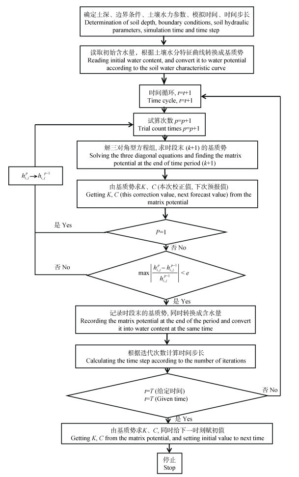
图1一维土壤水分运动模型程序设计流程图
Figure1.Flow chart of procedure design of one dimensional soil water movement model
 下载: 全尺寸图片幻灯片
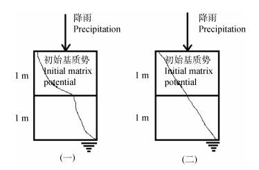
图2Yeh解析解设置的两组层状土壤示意图
Figure2.Schematic diagram of two groups of stratified soils set by Yeh analytical solution
下载: 全尺寸图片幻灯片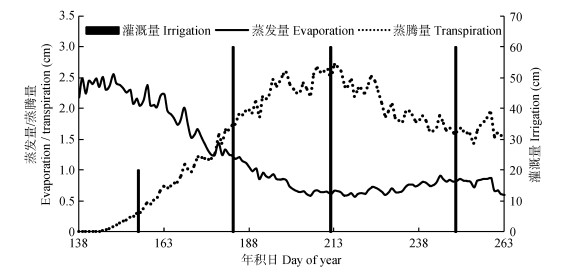
图3室内五水转化试验夏玉米生育期内蒸发量、蒸腾量和灌溉量
Figure3.Evaporation, transpiration and irrigation of summer maize measured at Water Transformation Dynamical Processes Experimental Device (WATDPED)
下载: 全尺寸图片幻灯片
图4第1组(a)和第2组(b)层状土壤剖面基质势的解析解(实线)和模拟值(虚线)
Figure4.Analytical (solid lines) and simulated (dashed lines) soil matric potentials of the stratified soil group one (a) and group two (b)
下载: 全尺寸图片幻灯片
图5室内五水转化动力过程试验层状土壤10 cm、33 cm、43 cm、53 cm深度处剖面含水量的实测值(实线)和模拟值(虚线)
Figure5.Simulated (dashed line) and measured (solid line) soil moistures of the stratified soils at 10 cm, 33 cm, 43 cm and 53 cm depths at the Water Transformation Dynamical Processes Experimental Device (WATDPED)
下载: 全尺寸图片幻灯片
图63种饱和导水率组合下层状土壤(实线)和均匀土壤(虚线)不同时间的剖面水分分布
Figure6.Soil water distribution profiles of layered (solid lines) and homogeneous (dashed lines) soil at different times under different hydraulic conductivity combinations
下载: 全尺寸图片幻灯片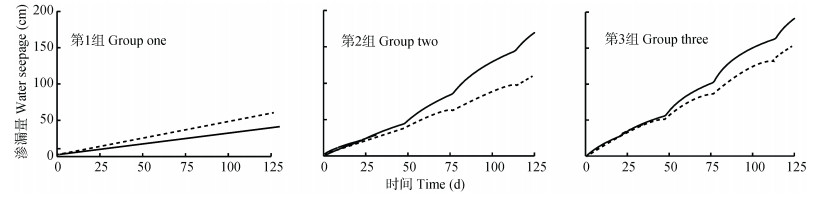
图73种饱和导水率组合下层状土壤(实线)和均匀土壤(虚线)渗漏量随时间的变化
Figure7.Water seepage of stratified soil (solid lines) and homogeneous soil (dashed lines) at different times under 3 hydraulic conductivity combinations
下载: 全尺寸图片幻灯片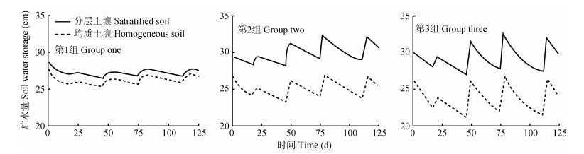
图83种饱和导水率组合下层状土壤(实线)和均匀土壤(虚线)储水量随时间的变化
Figure8.Water storage of stratified soil (solid lines) and homogeneous soil (dashed lines) under 3 hydraulic conductivity combinations
下载: 全尺寸图片幻灯片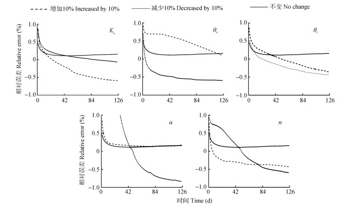
图9土壤水力参数饱和导水率(Ks)、饱和含水量(θs)、残余含水率(θr)、孔隙大小分布参数(α)和形状参数(n)增加或减少10%下土壤渗透量相对误差随时间的变化
Figure9.Change of relative error of water seepage over time under 10% increase and 10% decrease of soil hydraulic parameters saturated water conductivity (Ks), saturated water content (θs), residual water content (θr), soil pore size parameter (α) and shape parameter (n)
下载: 全尺寸图片幻灯片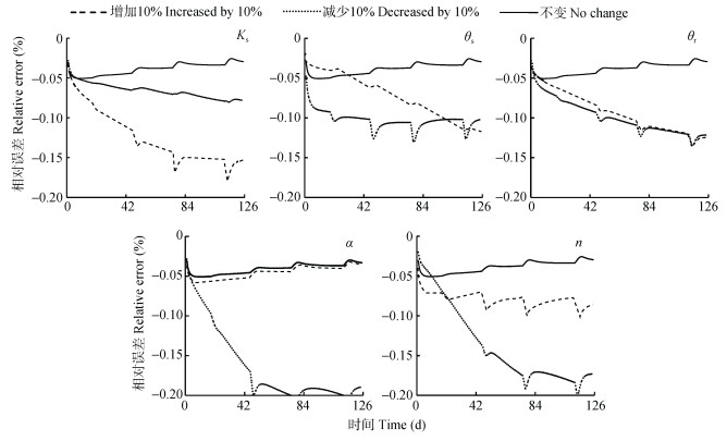
图10土壤水力参数饱和导水率(Ks)、饱和含水量(θs)、残余含水率(θr)、孔隙大小分布参数(α)和形状参数(n)增加或减少10%下土壤储水量相对误差随时间的变化
Figure10.Change of relative error of water storage over time under 10% increase and 10% decrease of soil hydraulic parameters saturated water conductivity (Ks), saturated water content (θs), residual water content (θr), soil pore size parameter (α) and shape parameter (n)
下载: 全尺寸图片幻灯片表1室内五水转化动力过程试验层状土壤不同深度处的土壤水力参数值
Table1.Soil hydraulic parameters at different depths of the stratified soils at Water Transformation Dynamical Processes Experimental Device (WATDPED)
| 土壤深度 Soil depth (cm) | 饱和导水率 Saturated water conductivity (Ks) (cm·d-1) | 残余含水量 Residual water content (θr) (cm3·cm-3) | 饱和含水量 Saturated water content (θs) (cm3·cm-3) | 土壤孔隙大小参数 Soil pore size parameter (α) (cm-1) | 土壤孔隙形状参数 Soil pore shape parameter (n) |
| 190 | 50.97 | 0.095 6 | 0.503 9 | 0.007 7 | 1.328 8 |
| 210 | 14.79 | 0.000 6 | 0.436 2 | 0.003 9 | 1.157 1 |
| 240 | 18.25 | 0.017 8 | 0.446 8 | 0.005 2 | 1.198 7 |
下载: 导出CSV表23种饱和导水率组合的垂向分层土壤和均匀土壤(以上层土壤代表)处理数值试验的土壤水力参数值
Table2.Soil hydraulic parameters for the numerical experiments of stratified soils under 3 hydraulic conductivity combinations and homogenous soils (represented by the upper layer soil)
| 组数 Group | 土层 Soil layer | 饱和导水率 Saturated water conductivity (Ks) (cm·d-1) | 饱和含水量 Saturated water content (θs) (cm3·cm-3) | 残余含水量 Residual water content (θr) (cm3·cm-3) | 土壤孔隙大小参数 Soil pore size parameter (α) (cm-1) | 土壤孔隙形状参数 Soil pore shape parameter (n) |
| 第1组 Group one | 上层Upper layer | 50.00 | 0.395 0 | 0.091 3 | 0.063 0 | 1.581 9 |
| 下层Lower layer | 31.44 | 0.390 0 | 0.100 0 | 0.059 0 | 1.480 0 | |
| 第2组 Group two | 上层Upper layer | 80.00 | 0.403 3 | 0.076 8 | 0.069 6 | 1.752 2 |
| 下层Lower layer | 31.44 | 0.390 0 | 0.100 0 | 0.059 0 | 1.480 0 | |
| 第3组 Group three | 上层Upper layer | 106.10 | 0.410 0 | 0.065 0 | 0.075 0 | 1.890 0 |
| 下层Lower layer | 31.44 | 0.390 0 | 0.100 0 | 0.059 0 | 1.480 0 |
下载: 导出CSV表3土壤水力参数敏感性试验方案
Table3.Schemes for soil hydraulic parameter sensitivity analysis
| 条件 Condition | 饱和导水率 Saturated water conductivity (Ks) (cm·d-1) | 饱和含水量 Saturated water content (θs) (cm3·cm-3) | 残余含水量 Residual water content (θr) (cm3·cm-3) | 土壤孔隙大小参数 Soil pore size parameter (α) (cm-1) | 土壤孔隙形状参数 Soil pore shape parameter (n) |
| 原始参数值Initial parameter value | 50.00 | 0.395 0 | 0.091 3 | 0.063 0 | 1.581 9 |
| 增加10% Increased by 10% | 55.00 | 0.434 5 | 0.100 4 | 0.069 3 | 1.740 1 |
| 减少10% Decreased by 10% | 45.00 | 0.355 5 | 0.082 2 | 0.056 7 | 1.423 7 |
下载: 导出CSV表4室内五水转化动力过程试验率定参数值
Table4.Calibrated parameters at Water Transformation Dynamical Processes Experimental Device (WATDPED)
| 土壤深度 Soil depth (cm) | 饱和导水率 Saturated water conductivity (Ks) (cm·d-1) | 饱和含水量 Saturated water content (θs) (cm3·cm-3) | 残余含水量 Residual water content (θr) (cm3·cm-3) | 土壤孔隙大小参数 Soil pore size parameter (α) (cm-1) | 土壤孔隙形状参数 Soil pore shape parameter (n) |
| 0~100 | 112.00 | 0.410 0 | 0.060 0 | 0.076 3 | 1.922 9 |
| 100~200 | 50.97 | 0.395 0 | 0.091 2 | 0.063 0 | 1.582 9 |
| 200~250 | 26.00 | 0.400 0 | 0.080 0 | 0.060 0 | 1.466 2 |
下载: 导出CSV参考文献
| [1] | KOSTER R D, DIRMEYER P A, GUO Z C, et al. Regions of strong coupling between soil moisture and precipitation[J]. Science, 2004, 305(5687):1138-1140 doi: 10.1126/science.1100217 |
| [2] | MAHMOOD R, HUBBARD K G. Simulating sensitivity of soil moisture and evapotranspiration under heterogeneous soils and land uses[J]. Journal of Hydrology, 2003, 280(1/4):72-90 http://www.sciencedirect.com/science/article/pii/S0022169403001835 |
| [3] | 李倩, 孙菽芬.陆面过程模型中垂直非均匀土壤的水分传输及相变的模拟[J].大气科学, 2015, 39(4):827-838 doi: 10.3878/j.issn.1006-9895.1411.14227 LI Q, SUN S F. The simulation of soil water flow and phase change in vertically inhomogeneous soil in land surface models[J]. Chinese Journal of Atmospheric Sciences, 2015, 39(4):827-838 doi: 10.3878/j.issn.1006-9895.1411.14227 |
| [4] | 雷志栋, 杨诗秀, 谢森传.土壤水动力学[M].北京:清华大学出版社, 1988 LEI Z D, YANG S X, XIE S C. Soil Hydrodynamics[M]. Beijing:Tsinghua University Press, 1988 |
| [5] | MOLZ F J. Water transport in the soil-root system:Transient analysis[J]. Water Resources Research, 1976, 12(4):805-808 doi: 10.1029/WR012i004p00805 |
| [6] | SZYMKIEWICZ A, HELMIG R. Comparison of conductivity averaging methods for one-dimensional unsaturated flow in layered soils[J]. Advances in Water Resources, 2011, 34(8):1012-1025 doi: 10.1016/j.advwatres.2011.05.011 |
| [7] | 周维博.降雨入渗和蒸发条件下野外层状土壤水分运动的数值模拟[J].水利学报, 1991, (9):32-36 http://www.cqvip.com/QK/90347X/199109/608383.html ZHOU W B. Numerical simulation of soil water movement in the field under rainfall infiltration and evaporation[J]. Jour-nal of Hydraulic Engineering, 1991, (9):32-36 http://www.cqvip.com/QK/90347X/199109/608383.html |
| [8] | VAN DAM J C, GROENENDIJK P, HENDRIKS R F A, et al. Advances of modeling water flow in variably saturated soils with SWAP[J]. Vadose Zone Journal, 2008, 7(2):640-653 doi: 10.2136/vzj2007.0060 |
| [9] | SRIVASTAVA R, YEH T C J. Analytical solutions for one-dimensional, transient infiltration toward the water table in homogeneous and layered soils[J]. Water Resources Re-search, 1991, 27(5):753-762 doi: 10.1029/90WR02772 |
| [10] | 谭丽萍. 主要生态与水文过程及其对变化响应的VIP模拟、实验验证与预测[D]. 北京: 中国科学院大学, 2016 http://www.wanfangdata.com.cn/details/detail.do?_type=degree&id=Y3106531 TAN L P. VIP simulation, experimental verification and pre-diction of the main ecological and hydrological processes and their response to change[D]. Beijing: University of Chinese Academy of Sciences, 2016 http://www.wanfangdata.com.cn/details/detail.do?_type=degree&id=Y3106531 |
| [11] | VOGEL T, CISLEROVA M. On the reliability of unsaturated hydraulic conductivity calculated from the moisture retention curve[J]. Transport in Porous Media, 1988, 3(1):1-15 doi: 10.1007/BF00222683 |
| [12] | VOGEL T, VAN GENUCHTEN M T, CISLEROVA M. Ef-fect of the shape of the soil hydraulic functions near satura-tion on variably-saturated flow predictions[J]. Advances in Water Resources, 2000, 24(2):133-144 doi: 10.1016/S0309-1708(00)00037-3 |
| [13] | 赵晶晶. 作物生长条件下土壤水分运动数值模拟[D]. 乌鲁木齐: 新疆农业大学, 2007 http://cdmd.cnki.com.cn/Article/CDMD-10758-2007136534.htm ZHAO J J. The numerical modeling for soil water movement under the condition of planting of crop[D]. Urumchi: Xinjiang Agricultural University, 2007 http://cdmd.cnki.com.cn/Article/CDMD-10758-2007136534.htm |
| [14] | 刘苏峡, 毛留喜, 莫兴国, 等.黄河沿岸陕豫区土壤水分的空间变化特征及其驱动力因子分析[J].气候与环境研究, 2008, 13(5):645-657 http://d.wanfangdata.com.cn/Periodical_qhyhjyj200805007.aspx LIU S X, MAO L X, MO X G, et al. Analysis of spatial vari-ability of soil moisture and its driving force factors in the Shaanxi-Henan Region along the Yellow River[J]. Climatic and Environmental Research, 2008, 13(5):645-657 http://d.wanfangdata.com.cn/Periodical_qhyhjyj200805007.aspx |
