武伟2, 3,
刘洪斌1, 3,,
1.西南大学资源环境学院 重庆 400716
2.西南大学计算机与信息科学学院 重庆 400715
3.重庆市数字农业重点实验室 重庆 400716
基金项目: 中央高校基本科研业务费专项XDJK2016D041
详细信息
作者简介:杨其坡, 主要从事土壤资源环境遥感与信息技术的研究。E-mail:Qipoyang@163.com
通讯作者:刘洪斌, 主要从事土壤调查与信息管理方面的研究。E-mail:lhbin@swu.edu.cn
中图分类号:S158.9计量
文章访问数:1141
HTML全文浏览量:0
PDF下载量:1827
被引次数:0
出版历程
收稿日期:2017-05-17
录用日期:2017-12-05
刊出日期:2018-03-01
Prediction of spatial distribution of soil available iron in a typical hilly farm-land using terrain attributes and random forest model
YANG Qipo1, 3,,WU Wei2, 3,
LIU Hongbin1, 3,,
1. College of Resources and Environment, Southwest University, Chongqing 400716, China
2. College of Computer and Information Science, Southwest University, Chongqing 400715, China
3. Chongqing Key Laboratory of Digital Agriculture, Chongqing 400716, China
Funds: the Fundamental Research Funds for the Central Universities of ChinaXDJK2016D041
More Information
Corresponding author:LIU Hongbin, E-mail:lhbin@swu.edu.cn
摘要
HTML全文
图
参考文献
相关文章
施引文献
资源附件
访问统计
摘要
摘要:为了掌握丘陵地区农田土壤有效铁含量及其空间分布,本文以重庆市江津区永兴镇内同源成土母质的典型丘陵(2 km2)为研究区,采集309个土壤样点,利用普通克里格(Ordinary Kriging,OK)、多元线性回归(Multiple Linear Regression,MLR)、随机森林(Random Forest,RF)模型,结合高程、坡度、坡向、谷深、平面曲率、剖面曲率、汇聚指数、相对坡位指数、地形湿度指数等地形因子对土壤有效铁进行空间分布预测,并通过85个验证点评价、筛选预测模型。结果表明:1)土壤有效铁与谷深、地形湿度指数存在极显著水平正相关关系,与坡度、平面曲率、剖面曲率、汇聚指数、相对坡位指数存在极显著水平负相关关系。2)随机森林模型的预测精度明显高于多元线性回归和普通克里格插值,其平均绝对误差为22.33 mg·kg-1、均方根误差为27.98 mg·kg-1、决定系数为0.76,是研究区土壤有效铁含量空间分布的最适预测模型。3)地形湿度指数和坡度是影响该区域土壤有效铁含量空间分布的主要地形因子。土壤有效铁与坡度、谷深、平面曲率、剖面曲率、汇聚指数、相对坡位指数、地形湿度指数均达到极显著水平相关关系。4)研究区土壤有效铁含量范围为3.00~276.97 mg·kg-1,水田有效铁含量大于旱地;土壤有效铁具有较强的空间相关性,土壤有效铁含量空间变异主要受到结构性因素的影响。可见,基于地形因子的随机森林预测模型可以较好地解释丘陵区农田土壤有效铁含量的空间变异,研究结果为丘陵区土壤中、微量元素含量及空间分布预测提供方法借鉴和理论依据。
关键词:地形因子/
随机森林模型/
土壤有效铁/
空间分布/
丘陵区农田
Abstract:Soil available iron is essential for plant growth. Detailed information on the spatial distribution of soil available iron is critical for effective management of soil fertility. To date, published works on soil available iron have mainly focused on the spatial variability and little has been done on predicting the spatial distribution of soil available iron. To understand the spatial distribution of soil available iron in hilly areas of Southwest China, we conducted a study in 2014 at a 2-km2 typical hilly region with uniform soil parent materials in Yongxing Town, Jiangjin County, Chongqing City. A total of 309 soil samples were collected from cultivated lands at the depth of 0-20 cm. The samples were randomly divided into calibration (224) and validation (85) samples. Nine terrain attributes (including elevation, slope, aspect, valley depth, horizontal curvature, profile curvature, convergence index, relation position index and topographic wetness index) were extracted from a digital elevation model of spatial resolution of 2.0 m. Ordinary Kriging (OK), Multiple Linear Regression (MLR) and Random Forest (RF) analyses were used to predict the content of soil available iron based on the terrain attributes. Accuracy indicators, including mean absolute error (MAE), root mean square error (RMSE) and coefficient of determination (R2), were used to evaluate model performance based on validation data. Correlation analysis showed that topographic wetness index and valley depth were significantly positively correlated with soil available iron content. Slope, horizontal curvature, profile curvature, convergence index and relative position index were on the other hand significantly negatively correlated with soil available iron content. Compared with OK and MLR, RF model performed best, with MAE=22.33 mg·kg-1, RMSE=27.98 mg·kg-1 and R2=0.76. Additionally, RF analysis indicated that topographic wetness and slope were the main factors controlling the spatial distribution of soil available iron. Soil available iron content in the study area was 3.00-276.97 mg·kg-1, which was higher for paddy field than for dryland. Semivariance model showed strong spatial autocorrelation of soil available iron, indicating that structural factors were the main driving force of spatial variation of soil available iron. Therefore it was concluded that the RF model together with terrain attributes well explained the spatial variability of soil available iron in the area. The result of the study provided valuable information for studies on predicting the spatial distribution of trace elements in soils in hilly areas.
Key words:Terrain attribute/
Random forest model/
Soil available iron/
Spatial distribution/
Hilly farmland
HTML全文
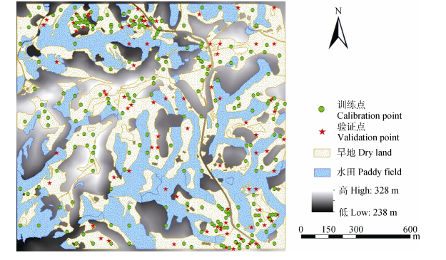
图1研究区DEM、土地利用及样点分布图
Figure1.Map of DEM, land use and samples sites of the study area
 下载: 全尺寸图片幻灯片
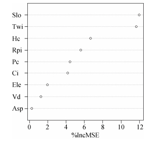
图2研究区土壤有效铁含量的随机森林自变量影响力评价
图中IncMSE为均方误差增加量; Slo为坡度; Twi为地形湿度指数; Hc为平面曲率; Rpi为相对坡位指数; Pc为剖面曲率; Ci为汇聚指数; Ele为高程; Vd为谷深; Asp为坡向。
Figure2.Influence evaluation of independent variables by Random Forest of soil available iron content in the study area
In the graph, IncMSE is increase in mean squared error; Slo is the slope; Twi is the topographic wetness index; Hc is the horizontal curvature; Rpi is the relation position index; Pc is the profile curvature; Ci is the Convergence index; Ele is the elevation; Vd is the valley depth; Asp is the aspect.
下载: 全尺寸图片幻灯片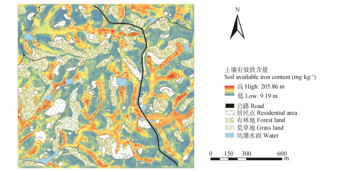
图3研究区土壤有效铁含量空间分布预测图
Figure3.Prediction map of soil available iron content in the study area
下载: 全尺寸图片幻灯片表1研究区采样点土壤有效铁含量描述性统计
Table1.Descriptive statistics of soil available iron content of the study area
| 样本组 Sample group | 样本数 Number of samples | 最小值 Minimum (mg·kg-1) | 最大值 Maximum (mg·kg-1) | 中值 Median (mg·kg-1) | 平均值 Mean (mg·kg-1) | 标准差 Std. deviation (mg·kg-1) | 变异系数 Coefficient of variation | 偏度 Skewness |
| 训练集?Calibration samples | 224 | 3.00 | 276.97 | 27.36 | 49.94 | 57.35 | 1.15 | 1.80 |
| 验证集?Validation samples | 85 | 4.20 | 208.38 | 26.44 | 49.55 | 53.85 | 1.09 | 1.49 |
下载: 导出CSV表2研究区土壤有效铁的半方差模型参数
Table2.Semivariance parameters of soil available iron in the study area
| 拟合模型 Model | 块金值 Nugget (C0) | 基台值 Sill (C0+C) | 块基比 Proportion [C0/(C0+C)] (%) | 变程 Range (m) | 决定系数R2 |
| 指数模型 Exponential | 560 | 3 858 | 14.5 | 561 | 0.898 |
下载: 导出CSV表3研究区土壤有效铁含量与地形因子的相关性
Table3.Correlations between soil available iron content and terrain attributes in the study area
| 高程 Elevation | 坡度 Slope | 坡向 Aspect | 谷深 Valley depth | 平面曲率 Horizontal curvature | 剖面曲率 Profile curvature | 汇聚指数 Convergence index | 相对坡位指数 Relation position index | 地形湿度指数 Topographic wetness index | |
| 土壤有效铁 Soil available iron | -0.116 | -0.371** | 0.086 | 0.298** | -0.327** | -0.228** | -0.174** | -0.428** | 0.592** |
| ??表中数据为训练集统计分析结果。*和**表明地形因子与土壤有效铁含量的相关性达显著(P < 0.05)和极显著(P < 0.01)水平。Data in the table are the results calculated based on the data of calibration samples. * and ** stand for that the relationships between terrain attributes and soil available iron content are significant at P < 0.05 and P < 0.01, respectively. | |||||||||
下载: 导出CSV表4研究区旱地和水田土壤有效铁含量的比较
Table4.Comparison of soil available iron content between dryland and paddy field
| 土地利用类型 Land use type | 样本数 Number of samples | 最小值 Minimum (mg·kg-1) | 最大值 Maximum (mg·kg-1) | 中值 Median (mg·kg-1) | 平均值 Mean (mg·kg-1) | 标准差 Std. deviation (mg·kg-1) | 变异系数 Coefficient of variation |
| 旱地?Dry land | 190 | 3.00 | 156.60 | 21.24 | 31.85 | 30.37 | 0.95 |
| 水田?Paddy field | 34 | 3.85 | 276.97 | 155.22 | 151.04 | 67.27 | 0.45 |
| ??表中的数据为训练集统计分析结果。Data in the table are the results calculated based on the data of training of set. | |||||||
下载: 导出CSV表5研究区土壤有效铁含量模型预测精度
Table5.Prediction accuracies of fitted models of soil available iron content in the study area
| 预测模型 Prediction model | 验证集?Validation dataset | ||
| MAE (mg·kg-1) | RMSE (mg·kg-1) | R2 | |
| 普通克里格?Ordinary Kriging | 32.97 | 52.38 | 0.11 |
| 多元线性回归 Multiple linear regression, | 23.58 | 35.25 | 0.60 |
| 随机森林?Random forest | 22.33 | 27.98 | 0.76 |
下载: 导出CSV参考文献
| [1] | 汪李平.植物的铁素营养及缺铁症的防治(综述)[J].安徽农业大学学报, 1995, 22(1): 17–22 http://www.oalib.com/paper/4833185 WANG L P. Review on iron nutrition and control of iron deficiency in plants[J]. Journal of Anhui Agricultural University, 1995, 22(1): 17–22 http://www.oalib.com/paper/4833185 |
| [2] | 申红芸, 熊宏春, 郭笑彤, 等.植物吸收和转运铁的分子生理机制研究进展[J].植物营养与肥料学报, 2011, 17(6): 1522–1530 doi: 10.11674/zwyf.2011.1057 SHEN H Y, XIONG H C, GUO X T, et al. Progress of molecular and physiological mechanism of iron uptake and translocation in plants[J]. Plant Nutrition and Fertilizer Science, 2011, 17(6): 1522–1530 doi: 10.11674/zwyf.2011.1057 |
| [3] | 李俊成, 于慧, 杨素欣, 等.植物对铁元素吸收的分子调控机制研究进展[J].植物生理学报, 2016, 52(6): 835–842 http://www.wanfangdata.com.cn/details/detail.do?_type=perio&id=zwxtb200706008 LI J C, YU H, YANG S X, et al. Research progress of molecular regulation of iron uptake in plants[J]. Plant Physiology Journal, 2016, 52(6): 835–842 http://www.wanfangdata.com.cn/details/detail.do?_type=perio&id=zwxtb200706008 |
| [4] | 张春梅.古浪灌区土壤耕层有效锌、锰、铜、铁含量分析与评价[J].草业科学, 2011, 28(6): 1221–1225 http://mall.cnki.net/magazine/Article/CYKX201106067.htm ZHANG C M. Analysis and evaluation of available Zn, Mn, Cu and Fe contents of topsoil in Gulang Irrigation Region[J]. Pratacultural Science, 2011, 28(6): 1221–1225 http://mall.cnki.net/magazine/Article/CYKX201106067.htm |
| [5] | 李强, 周冀衡, 杨荣生, 等.曲靖植烟土壤养分空间变异及土壤肥力适宜性评价[J].应用生态学报, 2011, 22(4): 950–956 http://www.cnki.com.cn/Article/CJFDTOTAL-YYSB201403024.htm LI Q, ZHOU J H, YANG R S, et al. Soil nutrients spatial variability and soil fertility suitability in Qujing tobacco-planting area[J]. Chinese Journal of Applied Ecology, 2011, 22(4): 950–956 http://www.cnki.com.cn/Article/CJFDTOTAL-YYSB201403024.htm |
| [6] | 武婕, 李玉环, 李增兵, 等.南四湖区农田土壤有机质和微量元素空间分布特征及影响因素[J].生态学报, 2014, 34(6): 1596–1605 http://www.ecologica.cn/stxb/ch/html/2014/6/stxb201307181906.htm WU J, LI Y H, LI Z B, et al. Spatial distribution and influencing factors of farmland soil organic matter and trace elements in the Nansihu Region[J]. Acta Ecologica Sinica, 2014, 34(6): 1596–1605 http://www.ecologica.cn/stxb/ch/html/2014/6/stxb201307181906.htm |
| [7] | Jenny H. The soil resource. Origin and behavior[J]. Vegetatio, 1984, 57(2/3): 102 https://sydney.edu.au/courses/units-of-study/2018/soil/soil2004.html |
| [8] | 黄安, 杨联安, 杜挺, 等.基于多元成土因素的土壤有机质空间分布分析[J].干旱区地理, 2015, 38(5): 994–1003 http://www.cqvip.com/QK/96344X/201505/666372617.html HUANG A, YANG L A, DU T, et al. Spatial distribution of the soil organic matter based on multiple soil factors[J]. Arid Land Geography, 2015, 38(5): 994–1003 http://www.cqvip.com/QK/96344X/201505/666372617.html |
| [9] | 李启权, 王昌全, 张文江, 等.基于神经网络模型和地统计学方法的土壤养分空间分布预测[J].应用生态学报, 2013, 24(2): 459–466 http://d.wanfangdata.com.cn/Periodical_yystxb201302022.aspx LI Q Q, WANG C Q, ZHANG W J, et al. Prediction of soil nutrients spatial distribution based on neural network model combined with goestatistics[J]. Chinese Journal of Applied Ecology, 2013, 24(2): 459–466 http://d.wanfangdata.com.cn/Periodical_yystxb201302022.aspx |
| [10] | 廖琴, 南忠仁, 王胜利, 等.干旱区绿洲农田土壤微量元素有效态含量空间分布特征[J].环境科学研究, 2011, 24(3): 273–280 http://plantnutrifert.org/CN/article/downloadArticleFile.do?attachType=PDF&id=4165 LIAO Q, NAN Z R, WANG S L, et al. Spatial distribution characteristics of available microelement contents in oasis cropland soils of arid areas[J]. Research of Environmental Sciences, 2011, 24(3): 273–280 http://plantnutrifert.org/CN/article/downloadArticleFile.do?attachType=PDF&id=4165 |
| [11] | 杜娟, 张永清, 周进财, 等.尧都区耕层土壤微量元素有效态含量空间分布特征[J].中国农学通报, 2014, 30(3): 162–167 doi: 10.11924/j.issn.1000-6850.2013-1051 DU J, ZHANG Y Q, ZHOU J C, et al. Spatial distribution characteristics of available microelements contents in irrigation-silted soil in Yaodu District[J]. Chinese Agricultural Science Bulletin, 2014, 30(3): 162–167 doi: 10.11924/j.issn.1000-6850.2013-1051 |
| [12] | 刘永红, 倪中应, 谢国雄, 等.浙西北丘陵区农田土壤微量元素空间变异特征及影响因子[J].植物营养与肥料学报, 2016, 22(6): 1710–1718 doi: 10.11674/zwyf.15343 LIU Y H, NI Z Y, XIE G X, et al. Spatial variability and impacting factors of trace elements in hilly region of cropland in northwestern Zhejiang Province[J]. Journal of Plant Nutrition and Fertilizer, 2016, 22(6): 1710–1718 doi: 10.11674/zwyf.15343 |
| [13] | 史文娇, 岳天祥, 石晓丽, 等.土壤连续属性空间插值方法及其精度的研究进展[J].自然资源学报, 2012, 27(1): 163–175 doi: 10.11849/zrzyxb.2012.01.017 SHI W J, YUE T X, SHI X L, et al. Research progress in soil property interpolators and their accuracy[J]. Journal of Natural Resources, 2012, 27(1): 163–175 doi: 10.11849/zrzyxb.2012.01.017 |
| [14] | 张国平, 郭澎涛, 王正银, 等.紫色土丘陵地区农田土壤养分空间分布预测[J].农业工程学报, 2013, 29(6): 113–120 https://www.wenkuxiazai.com/doc/eafd94cfd5bbfd0a79567342.html ZHANG G P, GUO P T, WANG Z Y, et al. Prediction of spatial distribution of hilly farmland with purple soil nutrient[J]. Transactions of the CSAE, 2013, 29(6): 113–120 https://www.wenkuxiazai.com/doc/eafd94cfd5bbfd0a79567342.html |
| [15] | WANG J J, CUI L J, GAO W X, et al. Prediction of low heavy metal concentrations in agricultural soils using visible and near-infrared reflectance spectroscopy[J]. Geoderma, 2014, 216: 1–9 doi: 10.1016/j.geoderma.2013.10.024 |
| [16] | 徐剑波, 宋立生, 夏振, 等.基于GARBF神经网络的耕地土壤有效磷空间变异分析[J].农业工程学报, 2012, 28(16): 158–165 doi: 10.3969/j.issn.1002-6819.2012.16.025 XU J B, SONG L S, XIA Z, et al. Spatial variability of available phosphorus for cultivated soil based on GARBF neural network[J]. Transactions of the CSAE, 2012, 28(16): 158–165 doi: 10.3969/j.issn.1002-6819.2012.16.025 |
| [17] | 石伟, 南卓铜, 李韧, 等.基于支持向量机的典型冻土区土壤制图研究[J].土壤学报, 2011, 48(3): 461–469 doi: 10.11766/trxb201007220297 SHI W, NAN Z T, LI R, et al. Support vector machine based soil mapping of a typical permafrost area in the Qinghai-Tibet Plateau[J]. Acta Pedologica Sinica, 2011, 48(3): 461–469 doi: 10.11766/trxb201007220297 |
| [18] | 芦园园, 张甘霖, 赵玉国, 等.复杂景观环境下土壤厚度分布规则提取与制图[J].农业工程学报, 2014, 30(18): 132–141 doi: 10.3969/j.issn.1002-6819.2014.18.017 LU Y Y, ZHANG G L, ZHAO Y G, et al. Extracting and mapping of soil depth distribution rules in complex landscape environment[J]. Transactions of the CSAE, 2014, 30(18): 132–141 doi: 10.3969/j.issn.1002-6819.2014.18.017 |
| [19] | LARK R M. Towards soil geostatistics[J]. Spatial Statistics, 2012, 1: 92–99 doi: 10.1016/j.spasta.2012.02.001 |
| [20] | COBURN T C. Geostatistics for natural resources evaluation[J]. Technometrics, 2000, 42(4): 437–438 http://www.gbv.de/dms/goettingen/229148123.pdf |
| [21] | 徐剑波, 宋立生, 彭磊, 等.土壤养分空间估测方法研究综述[J].生态环境学报, 2011, 20(8/9): 1379–1386 http://www.cqvip.com/QK/97636C/201108/39528150.html XU J B, SONG L S, PENG L, et al. Research review on methods of spatial prediction of soil nutrients[J]. Ecology and Environmental Sciences, 2011, 20(8/9): 1379–1386 http://www.cqvip.com/QK/97636C/201108/39528150.html |
| [22] | 丁建丽, 王飞.干旱区大尺度土壤盐度信息环境建模——以新疆天山南北中低海拔冲积平原为例[J].地理学报, 2017, 72(1): 64–78 http://www.geog.com.cn/article/2017/0375-5444/0375-5444-72-1-64.shtml DING J L, WANG F. Environmental modeling of large-scale soil salinity information in an arid region: A case study of the low and middle altitude alluvial plain north and south of the Tianshan Mountains, Xinjiang[J]. Acta Geographica Sinica, 2017, 72(1): 64–78 http://www.geog.com.cn/article/2017/0375-5444/0375-5444-72-1-64.shtml |
| [23] | BREIMAN L, FRIEDMAN J H, OLSHEN R A, et al. Classification and regression trees (CART)[J]. Biometrics, 1984, 40(3): 358 http://www.lisa.stat.vt.edu/sites/default/files/CART.pptx |
| [24] | BESALATPOUR A, HAJABBASI M, AYOUBI S, et al. Prediction of soil physical properties by optimized support vector machines[J]. International Agrophysics, 2012, 26(2): 109–115 https://www.researchgate.net/profile/A_Yousefian-Jazi |
| [25] | KOLEY S. Machine learning for soil fertility and plant nutrient management using back propagation neural networks[J]. Social Science Electronic Publishing, 2014, 2(2): 292–297 https://papers.ssrn.com/sol3/papers.cfm?abstract_id=2873448 |
| [26] | DIETTERICH T. Overfitting and undercomputing in machine learning[J]. ACM Computing Surveys, 1995, 27(3): 326–327 doi: 10.1145/212094.212114 |
| [27] | HAWKINS D M. The problem of overfitting[J]. Journal of Chemical Information and Computer Sciences, 2004, 44(1): 1–12 doi: 10.1021/ci0342472 |
| [28] | 郭澎涛, 李茂芬, 罗微, 等.基于多源环境变量和随机森林的橡胶园土壤全氮含量预测[J].农业工程学报, 2015, 31(5): 194–202 http://www.cqvip.com/QK/90712X/201505/665303090.html GUO P T, LI M F, LUO W, et al. Prediction of soil total nitrogen for rubber plantation at regional scale based on environmental variables and random forest approach[J]. Transactions of the CSAE, 2015, 31(5): 194–202 http://www.cqvip.com/QK/90712X/201505/665303090.html |
| [29] | 王茵茵, 齐雁冰, 陈洋, 等.基于多分辨率遥感数据与随机森林算法的土壤有机质预测研究[J].土壤学报, 2016, 53(2): 342–354 http://www.dqxxkx.cn/CN/Y2017/V19/I1/125 WANG Y Y, QI Y B, CHEN Y, et al. Prediction of soil organic matter based on multi-resolution remote sensing data and random forest algorithm[J]. Acta Pedologica Sinica, 2016, 53(2): 342–354 http://www.dqxxkx.cn/CN/Y2017/V19/I1/125 |
| [30] | 黄昌勇.土壤学[M].北京:中国农业出版社, 1999: 141–142 HUANG C Y. Soil Science[M]. Beijing: China Agriculture Press, 1999: 141–142 |
| [31] | 秦松, 樊燕, 刘洪斌, 等.地形因子与土壤养分空间分布的相关性研究[J].水土保持研究, 2008, 15(1): 46–49 http://www.cqvip.com/QK/90831A/201312/48095825.html QIN S, FAN Y, LIU H B, et al. Study on the relations between topographical factors and the spatial distributions of soil nutrients[J]. Research of Soil and Water Conservation, 2008, 15(1): 46–49 http://www.cqvip.com/QK/90831A/201312/48095825.html |
| [32] | 宋轩, 李立东, 寇长林, 等.黄水河小流域土壤养分分布及其与地形的关系[J].应用生态学报, 2011, 22(12): 3163–3168 http://www.cqvip.com/QK/90626A/201112/40160848.html SONG X, LI L D, KOU C L, et al. Soil nutrient distribution and its relations with topography in Huangshui River drainage basin[J]. Chinese Journal of Applied Ecology, 2011, 22(12): 3163–3168 http://www.cqvip.com/QK/90626A/201112/40160848.html |
| [33] | 连纲, 郭旭东, 傅伯杰, 等.基于环境相关法和地统计学的土壤属性空间分布预测[J].农业工程学报, 2009, 25(7): 237–242 http://www.cjae.net/CN/article/downloadArticleFile.do?attachType=PDF&id=18936 LIAN G, GUO X D, FU B J, et al. Prediction of the spatial distribution of soil properties based on environmental correlation and geostatistics[J]. Transactions of the CSAE, 2009, 25(7): 237–242 http://www.cjae.net/CN/article/downloadArticleFile.do?attachType=PDF&id=18936 |
| [34] | GRIMM R, BEHRENS T, M RKER M, et al. Soil organic carbon concentrations and stocks on Barro Colorado Island-Digital soil mapping using Random Forests analysis[J]. Geoderma, 2008, 146(1/2): 102–113 http://www.academia.edu/2058697/Soil_organic_carbon_concentrations_and_stocks_on_Barro_Colorado_Island_Digital_soil_mapping_using_Random_Forests_analysis |
| [35] | 张素梅, 王宗明, 张柏, 等.利用地形和遥感数据预测土壤养分空间分布[J].农业工程学报, 2010, 26(5): 188–194 https://www.wenkuxiazai.com/doc/a49a647e168884868762d68e.html ZHANG S M, WANG Z M, ZHANG B, et al. Prediction of spatial distribution of soil nutrients using terrain attributes and remote sensing data[J]. Transactions of the CSAE, 2010, 26(5): 188–194 https://www.wenkuxiazai.com/doc/a49a647e168884868762d68e.html |
| [36] | 鲍士旦.土壤农化分析[M].第3版.北京:中国农业出版社, 2002: 47–56 BAO S D. Soil and Agricultural Chemistry Analysis[M]. 3rd ed. Beijing: China Agriculture Press, 2002: 47–56 |
| [37] | 邓欧平, 周稀, 黄萍萍, 等.川中紫色丘区土壤养分空间分异与地形因子相关性研究[J].资源科学, 2013, 35(12): 2434–2443 http://www.dqxxkx.cn/CN/abstract/abstract38956.shtml DENG O P, ZHOU X, HUANG P P, et al. Correlations between spatial variability of soil nutrients and topographic factors in the purple hilly region of Sichuan[J]. Resources Science, 2013, 35(12): 2434–2443 http://www.dqxxkx.cn/CN/abstract/abstract38956.shtml |
| [38] | MOORE I D, GESSLER P E, NIELSEN G A, et al. Soil attribute prediction using terrain analysis[J]. Soil Science Society of America Journal, 1993, 57(2): 443–452 doi: 10.2136/sssaj1993.03615995005700020026x |
| [39] | 秦承志, 卢岩君, 包黎莉, 等.简化数字地形分析软件(SimDTA)及其应用——以嫩江流域鹤山农场区的坡位模糊分类为例[J].地球信息科学学报, 2009, 11(6): 737–743 http://d.wanfangdata.com.cn/Periodical_dqxxkx200906008.aspx QIN C Z, LU Y J, BAO L L, et al. Simple digital terrain analysis software (SimDTA 1.0) and its application in fuzzy classification of slope positions[J]. Journal of Geo-information Science, 2009, 11(6): 737–743 http://d.wanfangdata.com.cn/Periodical_dqxxkx200906008.aspx |
| [40] | 呼雪梅, 秦承志.地形信息对确定DEM适宜分辨率的影响[J].地理科学进展, 2014, 33(1): 50–56 doi: 10.11820/dlkxjz.2014.01.006 HU X M, QIN C Z. Effects of different topographic attributes on determining appropriate DEM resolution[J]. Progress in Geography, 2014, 33(1): 50–56 doi: 10.11820/dlkxjz.2014.01.006 |
| [41] | 黄骁力, 汤国安, 刘凯. DEM分辨率对地形纹理特征提取的影响[J].地球信息科学学报, 2015, 17(7): 822–829 http://www.cqvip.com/QK/86408X/201507/665174516.html HUANG X L, TANG G A, LIU K. The influence of DEM resolution on the extraction of terrain texture feature[J]. Journal of Geo-information Science, 2015, 17(7): 822–829 http://www.cqvip.com/QK/86408X/201507/665174516.html |
| [42] | ZIMMERMAN D L, ZIMMERMAN M B. A comparison of spatial semivariogram estimators and corresponding ordinary kriging predictors[J]. Technometrics, 1991, 33(1): 77–91 doi: 10.1080/00401706.1991.10484771 |
| [43] | FEDOTOVA O, TEIXEIRA L, ALVELOS H. Software effort estimation with multiple linear regression: Review and practical application[J]. Journal of Information Science and Engineering, 2013, 29(5): 925–945 http://citeseerx.ist.psu.edu/viewdoc/summary?doi=10.1.1.683.6920 |
| [44] | LINDNER C, BROMILEY P A, IONITA M C, et al. Robust and accurate shape model matching using random forest regression-voting[J]. IEEE Transactions on Pattern Analysis and Machine Intelligence, 2015, 37(9): 1862–1874 doi: 10.1109/TPAMI.2014.2382106 |
| [45] | GOOVAERTS P. Geostatistical tools for characterizing the spatial variability of microbiological and physico-chemical soil properties[J]. Biology and Fertility of Soils, 1998, 27(4): 315–334 doi: 10.1007/s003740050439 |
| [46] | LIAW A, WIENER M. Breiman and Cutler's random forests for classification and regression. R Package Version 4. 6–7[R]. 2013 https://www.mendeley.com/research-papers/breiman-cutlers-random-forests-classification-regression/ |
| [47] | 徐小逊, 张世熔, 余妮娜, 等.沱江中游土壤有效铁空间分布及其影响因素分析[J].西南农业学报, 2012, 25(3): 977–981 http://industry.wanfangdata.com.cn/dl/Detail/Periodical?id=Periodical_xnnyxb201203048 XU X X, ZHANG S R, YU N N, et al. Soil available iron spatial distribution and influencing factors analysis based on GIS in middle reaches of Tuojiang[J]. Southwest China Journal of Agricultural Sciences, 2012, 25(3): 977–981 http://industry.wanfangdata.com.cn/dl/Detail/Periodical?id=Periodical_xnnyxb201203048 |
| [48] | 韩建平, 贾宁凤.土地利用与地形因子关系研究——以砖窑沟流域为例[J].中国生态农业学报, 2010, 18(5): 1071–1075 http://www.ecoagri.ac.cn/zgstny/ch/reader/view_abstract.aspx?file_no=201051071&flag=1 HAN J P, JIA N F. Relationship between topographic factor and land use — A case study of Zhuanyaogou watershed[J]. Chinese Journal of Eco-Agriculture, 2010, 18(5): 1071–1075 http://www.ecoagri.ac.cn/zgstny/ch/reader/view_abstract.aspx?file_no=201051071&flag=1 |
| [49] | 哈凯, 丁庆龙, 门明新, 等.山地丘陵区土地利用分布及其与地形因子关系——以河北省怀来县为例[J].地理研究, 2015, 34(5): 909–921 http://www.wanfangdata.com.cn/details/detail.do?_type=perio&id=dlyj201505010 HA K, DING Q L, MEN M X, et al. Spatial distribution of land use and its relationship with terrain factors in hilly area[J]. Geographical Research, 2015, 34(5): 909–921 http://www.wanfangdata.com.cn/details/detail.do?_type=perio&id=dlyj201505010 |
| [50] | 武爱彬, 刘欣, 赵艳霞.地形因子对浅山丘陵区土地利用类型分布与转换的影响——以燕山浅山丘陵区为例[J].农业现代化研究, 2014, 35(1): 103–107 http://kns.cnki.net/KCMS/detail/detail.aspx?filename=nxdh201401028&dbname=CJFD&dbcode=CJFQ WU A B, LIU X, ZHAO Y X. Influences of topographic on distribution and change of land use types in hilly region — Taking Yanshan hilly region as an example[J]. Research of Agricultural Modernization, 2014, 35(1): 103–107 http://kns.cnki.net/KCMS/detail/detail.aspx?filename=nxdh201401028&dbname=CJFD&dbcode=CJFQ |
| [51] | 张丽萍, 王小云, 张赫斯.沙盖黄土丘陵坡地土壤理化特性随地形变化规律研究[J].地理科学, 2011, 31(2): 178–183 http://www.oalib.com/paper/4170413 ZHANG L P, WANG X Y, ZHANG H S. Evolution of physical and chemical characteristics of loess with different landforms in slope field under sand cover[J]. Scientia Geographica Sinica, 2011, 31(2): 178–183 http://www.oalib.com/paper/4170413 |
| [52] | 徐国策, 李占斌, 李鹏, 等.丹江鹦鹉沟小流域土壤侵蚀和养分损失定量分析[J].农业工程学报, 2013, 29(10): 160–167 http://www.irgrid.ac.cn/handle/1471x/874077 XU G C, LI Z B, LI P, et al. Quantitative analysis of soil erosion and nutrient loss in Yingwugou watershed of the Dan River[J]. Transactions of the CSAES, 2013, 29(10): 160–167 http://www.irgrid.ac.cn/handle/1471x/874077 |
| [53] | 吴昊.秦岭山地松栎混交林土壤养分空间变异及其与地形因子的关系[J].自然资源学报, 2015, 30(5): 858–869 doi: 10.11849/zrzyxb.2015.05.013 WU H. The relationship between terrain factors and spatial variability of soil nutrients for pine-oak mixed forest in Qinling Mountains[J]. Journal of Natural Resources, 2015, 30(5): 858–869 doi: 10.11849/zrzyxb.2015.05.013 |
| [54] | 王丽, 王力, 王全九.不同坡度坡耕地土壤氮磷的流失与迁移过程[J].水土保持学报, 2015, 29(2): 69–75 http://www.cqvip.com/QK/96166A/201502/664320486.html WANG L, WANG L, WANG Q J. The processes of nitrogen and phosphorus loss and migration in slope cropland under different slopes[J]. Journal of Soil and Water Conservation, 2015, 29(2): 69–75 http://www.cqvip.com/QK/96166A/201502/664320486.html |
| [55] | 郑子成, 秦凤, 李廷轩.不同坡度下紫色土地表微地形变化及其对土壤侵蚀的影响[J].农业工程学报, 2015, 31(8): 168–175 https://wuxizazhi.cnki.net/qikan-TRQS201705007.html ZHENG Z C, QIN F, LI T X. Changes in soil surface microrelief of purple soil under different slope gradients and its effects on soil erosion[J]. Transactions of the CSAE, 2015, 31(8): 168–175 https://wuxizazhi.cnki.net/qikan-TRQS201705007.html |
| [56] | 张彩霞, 杨勤科, 李锐.基于DEM的地形湿度指数及其应用研究进展[J].地理科学进展, 2005, 24(6): 116–123 doi: 10.11820/dlkxjz.2005.06.014 ZHANG C X, YANG Q K, LI R. Advancement in topographic wetness index and its application[J]. Progress in Geography, 2005, 24(6): 116–123 doi: 10.11820/dlkxjz.2005.06.014 |
| [57] | LEWIS G L, HOLDEN N M. The modification of soil moisture deficit calculation using topographic wetness index to account for the effect of slope and landscape position[R]//Dallas, Texas: American Society of Agricultural and Biological Engineers, St. Joseph, 2012 https://www.researchgate.net/publication/271421774_The_Modification_of_Soil_Moisture_Deficit_Calculation_Using_Topographic_Wetness_Index_to_Account_For_the_Effect_of_Slope_and_Landscape_Position |
| [58] | MADUAKO I N, NDUKWU R I, IFEANYICHUKWU C, et al. Multi-index soil moisture estimation from satellite earth observations: Comparative evaluation of the topographic wetness index (TWI), the temperature vegetation dryness index (TVDI) and the improved TVDI (iTVDI)[J]. Journal of the Indian Society of Remote Sensing, 2017, 45(4): 631–642 doi: 10.1007/s12524-016-0635-9 |
| [59] | ZHU H F, HU W, BI R T, et al. Scale-and location-specific relationships between soil available micronutrients and environmental factors in the Fen River basin on the Chinese Loess Plateau[J]. Catena, 2016, 147: 764–772 doi: 10.1016/j.catena.2016.08.038 |
| [60] | ZHU H F, ZHAO Y, NAN F, et al. Relative influence of soil chemistry and topography on soil available micronutrients by structural equation modeling[J]. Journal of Soil Science and Plant Nutrition, 2016, 16(4): 1038–1051 https://scielo.conicyt.cl/scielo.php?script=sci_arttext&pid=S0718-95162016000400015 |
