赵小敏1, 3, 4,,,
欧阳真程1, 2,
郭熙1, 2, 3,
李伟峰1, 2,
匡丽花4,
叶英聪1, 2,
黄聪1, 2,
汪晓燕1, 2
1.江西农业大学江西省鄱阳湖流域农业资源与生态重点实验室/南方粮油作物协同创新中心 南昌 330045
2.江西农业大学国土资源与环境学院 南昌 330045
3.江西农业大学土地科学研究所 南昌 330045
4.南京农业大学公共管理学院 南京 210095
基金项目: 国家自然科学基金项目41361049
江西省自然科学基金项目20122BAB204012
详细信息
作者简介:张晗, 主要从事土地遥感与信息、土地利用规划和耕地质量监测等研究。E-mail:zhanghan0307@163.com
通讯作者:赵小敏, 主要从事农业遥感与信息技术、土地规划和土地资源利用等研究。E-mail:zhaoxm889@126.com
中图分类号:F301.21计量
文章访问数:1096
HTML全文浏览量:14
PDF下载量:1057
被引次数:0
出版历程
收稿日期:2017-06-03
录用日期:2017-08-03
刊出日期:2018-02-01
Multi-scale spatial autocorrelation analysis of cultivated land quality in China's southern hillside areas: A case study of Lichuan County, Jiangxi Province
ZHANG Han1, 2, 3,,ZHAO Xiaomin1, 3, 4,,,
OUYANG Zhencheng1, 2,
GUO Xi1, 2, 3,
LI Weifeng1, 2,
KUANG Lihua4,
YE Yingcong1, 2,
HUANG Cong1, 2,
WANG Xiaoyan1, 2
1. Key Laboratory of Poyang Lake Basin Agricultural Resources and Ecology of Jiangxi Province, Jiangxi Agricultural University/Southern Regional Collaborative Innovation Center for Grain and Oil Crops in China, Nanchang 330045, China
2. College of Land Resources and Environment, Jiangxi Agricultural University, Nanchang 330045, China
3. Institute of Land Science, Jiangxi Agricultural University, Nanchang 330045, China
4. College of Public Administration, Nanjing Agricultural University, Nanjing 210095, China
Funds: the National Natural Science Foundation of China41361049
the Natural Science Foundation of Jiangxi Province20122BAB204012
More Information
Corresponding author:ZHAO Xiaomin, E-mail:zhaoxm889@126.com
摘要
HTML全文
图
参考文献
相关文章
施引文献
资源附件
访问统计
摘要
摘要:分析不同尺度下的耕地质量空间分布格局,是提高耕地质量与加强耕地保护建设的基础。选取耕地质量等别监测试点县江西省黎川县为研究区,运用加权平均法、变异系数法和空间自相关分析法,以国家级耕地质量指数为空间变量,分别从县级、乡镇级和村级尺度上探讨了耕地质量的空间关联程度及其分异规律。研究结果表明:1)研究区耕地质量呈现出"南北高,东西低"的空间分布规律,耕地质量指数Mora's I值表现为国家利用等指数>国家经济等指数>国家自然等指数,县级、乡镇级和村级耕地质量指数的Moran's I值依次降低,三者均呈显著的空间正自相关集聚态势。2)随着空间尺度的不同,耕地质量指数具有不同的空间关联度,自然等指数受空间尺度影响较大,经济等指数其次,利用等指数最小。3)正相关高-高型和低-低型耕地以组团形式聚集分布,负相关高-低型和低-高型耕地无明显的集中区域,多以零星状分布。研究结果显示耕地质量空间差异对空间尺度的变化较为敏感,可为区域高标准基本农田建设、土地综合整治、耕地质量监测和耕地保护与管理分区提供借鉴参考。
关键词:山地丘陵区/
耕地质量/
空间自相关/
空间尺度/
黎川县
Abstract:Cultivated lands are among the most fundamental resources for national food security and sustainable social development. Scientific analysis of the spatial distribution patterns and evolutionary characteristics of cultivated land quality is significant for the protection and layout optimization of cultivated lands. Analysis of the spatial distribution of cultivated land quality at different scales is the basis of cultivated land quality improvement and strengthening of cultivated land protection. This paper was based on cultivated land quality monitoring experimental unit in Lichuan County in Jiangxi Province and then used weighted average, variation coefficient, and spatial autocorrelation to analyze spatial disparity characteristics of cultivated land quality. Multi-scale spatial autocorrelation analysis of cultivated land quality research is a hot research area. The innovation in this paper was the introduction of natural land grade index, use of the grade index and economic grade index as the space variable to separately explore and discuss the degree of spatial correlation and spatial disparity of cultivated land quality at county-scale, township-scale and village-scale in GIS environment. The results of the research showed that:1) Cultivated land quality index was high in the south and north and low in the west and east in Lichuan County. When the threshold distance was 400 m, there was a significant spatial autocorrelation in cultivated land quality. The Moran's I value of natural land grade index was highest, followed by economical land grade index, and land use grade index was the lowest. The Moran's I value of cultivated land quality from county to township and then to village scales decreased systematically. Multi-scale spatial autocorrelation analysis of cultivated land quality exhibited a significant aggregation of spatial distribution in Lichuan County. 2) It was found that different types of cultivated land quality indexes had remarkably different spatial correlations at different spatial scales. For the influence degree of spatial scale, land use grade index was greatly affected by spatial scale, followed by natural land index, and the economic land grade index was the weakest. For the coefficient of variation of cultivated land quality index, fluctuation in Moran's I value for cultivated land at village-scale was far greater than that at township scale. While at the same spatial scale, the coefficient of variation of natural land index was strongest, followed by economic land index and then land use index. 3) The results based on local indicators of spatial association (LISA) showed that positive spatial autocorrelation of cultivated land quality, included the high-high type and the low-low type, emerged as the shape of the cluster and in the form of group, while the negative spatial autocorrelation contained the high-low type and low-high type was fragmented in space. The results of the study showed that spatial disparity in cultivated land quality was sensitive to spatial scale. Therefore, for cultivated land quality improvement and protection, there was the need to pay more attention to spatial disparity of cultivated land quality at town scale and village scale. Also based on the difference in spatial correlation degree among the natural conditions, utilization conditions and economic benefits, it was possible to explore cultivated land quality improvement and protection measures that met actual ground situations in the study area. The results of the study provided the needed references for the construction of high-standard basic farmlands, land reclamation, regional cultivated land quality monitoring, cultivated land protection, partitioning and management of cultivated lands, cultivated land quality improvement and spatial optimization of cultivated land quality.
Key words:Mountain-hilly area/
Cultivated land quality/
Spatial autocorrelation/
Spatial scale/
Lichuan County
HTML全文
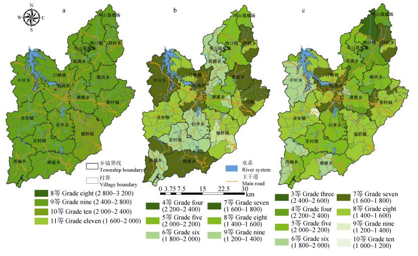
图1黎川县各行政村耕地国家自然等指数(a)、国家利用等指数(b)和国家经济等指数(c)分布图
Figure1.Distribution maps of land natural grade index (a), land use grade index (b) and land economical grade index (c) of cultivated land on village scale of Lichuan County
 下载: 全尺寸图片幻灯片
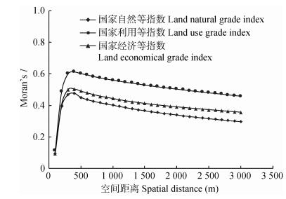
图2不同空间尺度下研究区耕地质量3类指数空间自相关图
Figure2.Spatial autocorrelation of cultivated land quality indexes in different spatial scales
下载: 全尺寸图片幻灯片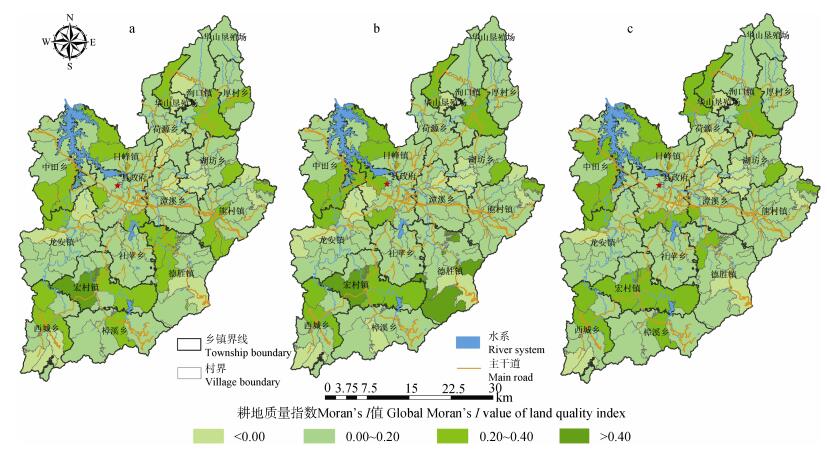
图3黎川县各行政村耕地国家自然等指数(a)、国家利用等指数(b)和国家经济等指数(c)全局Moran’s I值空间分布图
Figure3.Spatial distribution maps of Global Moran's I values of land natural grade index (a), land use grade index (b) and land economical grade index (c) of cultivated land on village scale of Lichuan County
下载: 全尺寸图片幻灯片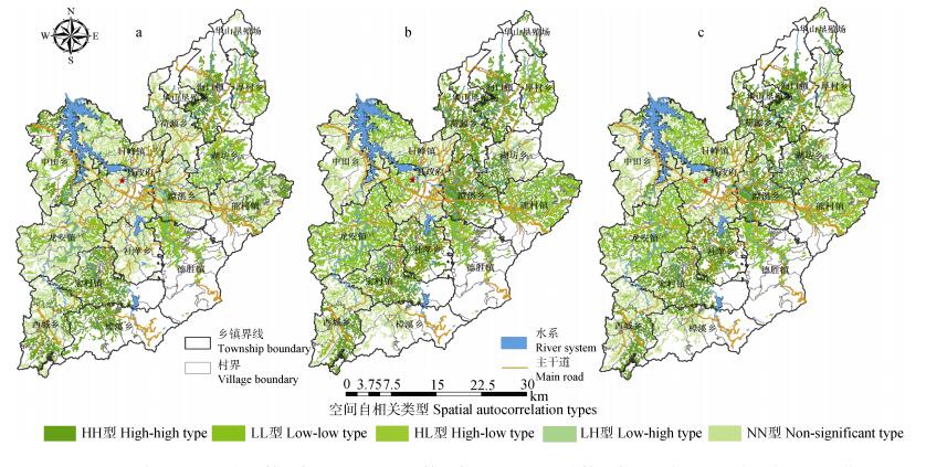
图4黎川县村级耕地国家自然等指数(a)、国家利用等指数(b)和国家经济等指数(c)空间关联局部指标(LISA)集聚图
Figure4.Cluster maps of of land natural grade index (a), land use grade index (b) and land economical grade index (c) of cultivated land with local indicators of spatial association (LISA) on village scale in Lichuan County
下载: 全尺寸图片幻灯片表1黎川县耕地质量指数Moran’s I值
Table1.Global Moran's I values of land quality indexes in Lichuan County
| 耕地质量指数 Land quality index | Moran’s I | Zscore | P | 标准化统计量阈值 Threshold value (α=0.05) |
| 国家自然等指数 Land natural grade index | 0.474 8 | 109.36 | 0 | 1.96 |
| 国家利用等指数 Land use grade index | 0.621 4 | 146.47 | 0 | 1.96 |
| 国家经济等指数 Land economical grade index | 0.512 2 | 120.73 | 0 | 1.96 |
下载: 导出CSV表2黎川县各乡镇耕地质量指数Moran’s I值
Table2.Global Moran's I values of land quality indexes in towns of Lichuan County
| 乡镇名称 Town name | 国家自然等指数 Land natural grade index | 国家利用等指数 Land use grade index | 国家经济等指数 Land economical grade index |
| 德胜镇 Desheng Town | 0.399 2 | 0.459 3 | 0.222 4 |
| 荷源乡 Heyuan Town | 0.195 9 | 0.163 3 | 0.159 7 |
| 宏村镇 Hongcun Town | 0.207 5 | 0.227 5 | 0.234 5 |
| 厚村乡 Houcun Town | 0.180 2 | 0.305 7 | 0.234 6 |
| 湖坊乡 Hufang Town | 0.125 8 | 0.354 0 | 0.193 8 |
| 龙安镇 Long’an Town | 0.189 8 | 0.170 3 | 0.325 5 |
| 日峰镇 Rifeng Town | 0.444 6 | 0.481 0 | 0.290 0 |
| 社苹乡 Sheping Town | 0.189 9 | 0.115 8 | 0.168 7 |
| 潭溪乡 Tanxi Town | 0.068 2 | 0.206 2 | 0.142 5 |
| 西城乡 Xicheng Town | 0.110 1 | 0.368 0 | 0.243 2 |
| 熊村镇 Xiongcun Town | 0.150 4 | 0.178 2 | 0.403 3 |
| 洵口镇 Xunkou Town | 0.167 2 | 0.115 4 | 0.161 0 |
| 樟溪乡 Zhangxi Town | 0.155 6 | 0.263 5 | 0.625 8 |
| 中田乡 Zhongtian Town | 0.346 8 | 0.371 6 | 0.347 3 |
| 华山垦殖场 Huashan Farm | 0.220 7 | 0.122 4 | 0.122 3 |
| 乡镇平均值 Average | 0.210 1 | 0.260 1 | 0.258 3 |
下载: 导出CSV表3不同空间尺度下的耕地质量全局Moran’s I值
Table3.Global Moran's I values of cultivated land quality indexes on different spatial scales in Lichuan County
| 项目Item | 尺度 Scale | 国家自然等指数 Land natural grade index | 国家利用等指数 Land use grade index | 国家经济等指数 Land economical grade index |
| 平均值Mean | 县级County | 0.474 8 | 0.621 4 | 0.512 2 |
| 乡镇级Township | 0.210 1 | 0.260 1 | 0.258 3 | |
| 村级Village | 0.143 5 | 0.147 9 | 0.146 8 | |
| 变异系数 Coefficient of variation | 乡镇级Township | 0.504 0 | 0.473 4 | 0.502 1 |
| 村级Village | 0.788 2 | 0.773 6 | 0.784 4 |
下载: 导出CSV参考文献
| [1] | 陈桂坤, 张蕾娜, 程锋, 等.数量质量并重管理的耕地保护政策研究[J].中国土地科学, 2009, 23(12):39-43 doi: 10.3969/j.issn.1001-8158.2009.12.007 CHEN G S, ZHANG L N, CHENG F, et al. Cultivated land preservation policies reexamined:Paying equal attention to quantitative and qualitative management[J]. China Land Science, 2009, 23(12):39-43 doi: 10.3969/j.issn.1001-8158.2009.12.007 |
| [2] | 徐明岗, 卢昌艾, 张文菊, 等.我国耕地质量状况与提升对策[J].中国农业资源与区划, 2016, 37(7):8-14 doi: 10.7621/cjarrp.1005-9121.20160703 XU M G, LU C A, ZHANG W J, et al. Situation of the quality of arable land in China and improvement strategy[J]. Chinese Journal of Agricultural Resources and Regional Planning, 2016, 37(7):8-14 doi: 10.7621/cjarrp.1005-9121.20160703 |
| [3] | 韦仕川, 熊昌盛, 栾乔林, 等.基于耕地质量指数局部空间自相关的耕地保护分区[J].农业工程学报, 2014, 30(18):249-256 doi: 10.3969/j.issn.1002-6819.2014.18.031 WEI S C, XIONG C S, LUAN Q L, et al. Protection zoning of arable land quality index based on local spatial autocorrelation[J]. Transactions of the CSAE, 2014, 30(18):249-256 doi: 10.3969/j.issn.1002-6819.2014.18.031 |
| [4] | 沈仁芳, 陈美军, 孔祥斌, 等.耕地质量的概念和评价与管理对策[J].土壤学报, 2012, 49(6):1210-1217 doi: 10.11766/trxb201208130319 SHEN R F, CHEN M J, KONG X B, et al. Conception and evaluation of quality of arable land and strategies for its management[J]. Acta Pedologica Sinica, 2012, 49(6):1210-1217 doi: 10.11766/trxb201208130319 |
| [5] | 陈诚, 林晨.苏南地区耕地质量评价与分区保护研究[J].长江流域资源与环境, 2016, 25(12):1860-1869 doi: 10.11870/cjlyzyyhj201612009 CHEN C, LIN C. Cultivated land quality assessment and protection zoning in Southern Jiangsu[J]. Resources and Environment in the Yangtze Basin, 2016, 25(12):1860-1869 doi: 10.11870/cjlyzyyhj201612009 |
| [6] | 杨永侠, 王旭, 孟丹, 等.基于空间自相关的耕地等别指数检验方法研究[J].农业机械学报, 2016, 47(5):328-335 doi: 10.6041/j.issn.1000-1298.2016.05.045 YANG Y X, WANG X, MENG D, et al. Test method of cultivated land grading index based on spatial autocorrelation[J]. Transactions of the Chinese Society for Agricultural Machinery, 2016, 47(5):328-335 doi: 10.6041/j.issn.1000-1298.2016.05.045 |
| [7] | 张贞, 魏朝富, 尚慧.丘陵山区耕地质量的空间格局分析[J].长江流域资源与环境, 2010, 19(8):901-907 http://www.docin.com/p-512379130.html ZHANG Z, WEI C F, SHANG H. Spatial pattern analysis based on modified cultivated quality grades in hilly area[J]. Resources and Environment in the Yangtze Basin, 2010, 19(8):901-907 http://www.docin.com/p-512379130.html |
| [8] | 杨建宇, 杜贞容, 杜振博, 等.基于耕地质量评价和局部空间自相关的高标准农田划定[J].农业机械学报, 2017, 48(6):109-115 https://www.wenkuxiazai.com/doc/7d89b886964bcf84b8d57b67.html YANG J Y, DU Z R, DU Z B, et al. Well-facilitied capital farmland assignment based on land quality evaluation and LISA[J]. Transactions of the Chinese Society for Agricultural Machinery, 2017, 48(6):109-115 https://www.wenkuxiazai.com/doc/7d89b886964bcf84b8d57b67.html |
| [9] | 陈藜藜, 宋戈, 邹朝晖, 等.基于改进局部空间自相关分析的萝北县耕地保护分区[J].资源科学, 2016, 38(10):1871-1882 http://lib.cqvip.com/qk/90831A/201610 CHEN L L, SONG G, ZOU C H, et al. Zoning of protected cultivated land based on improved local indicators of spatial association[J]. Resources Science, 2016, 38(10):1871-1882 http://lib.cqvip.com/qk/90831A/201610 |
| [10] | 王洪波, 程锋, 张中帆, 等.中国耕地等别分异特性及其对耕地保护的影响[J].农业工程学报, 2011, 27(11):1-8 doi: 10.3969/j.issn.1002-6819.2011.11.001 WANG H B, CHENG F, ZHANG Z F, et al. Differential characteristics of cultivated land grade and its effect on cultivated land protection in China[J]. Transactions of the CSAE, 2011, 27(11):1-8 doi: 10.3969/j.issn.1002-6819.2011.11.001 |
| [11] | 孔祥斌, 张青璞.中国西部区耕地等别空间分布特征[J].农业工程学报, 2012, 28(22):1-7 doi: 10.3969/j.issn.1002-6819.2012.22.001 KONG X B, ZHANG Q P. Spatial distribution characteristics of arable land grade in Western China[J]. Transactions of the CSAE, 2012, 28(22):1-7 doi: 10.3969/j.issn.1002-6819.2012.22.001 |
| [12] | 李武艳, 朱从谋, 王华, 等.浙江省耕地质量多尺度空间自相关分析[J].农业工程学报, 2016, 32(23):239-245 doi: 10.11975/j.issn.1002-6819.2016.23.033 LI W Y, ZHU C M, WANG H, et al. Multi-scale spatial autocorrelation analysis of cultivated land quality in Zhejiang Province[J]. Transactions of the CSAE, 2016, 32(23):239-245 doi: 10.11975/j.issn.1002-6819.2016.23.033 |
| [13] | 任平, 吴涛, 周介铭.基于GIS和空间自相关模型的耕地空间分布格局及变化特征分析——以成都市龙泉驿区为例[J].中国生态农业学报, 2016, 24(3):325-334 http://www.ecoagri.ac.cn/zgstny/ch/reader/view_abstract.aspx?file_no=2016307&flag=1 REN P, WU T, ZHOU J M. Analysis of spatial distribution pattern and evolutionary characteristics of cultivated lands based on spatial autocorrelation model and GIS platform-A case study of Longquanyi District, Chengdu, China[J]. Chinese Journal of Eco-Agriculture, 2016, 24(3):325-334 http://www.ecoagri.ac.cn/zgstny/ch/reader/view_abstract.aspx?file_no=2016307&flag=1 |
| [14] | 熊昌盛, 韦仕川, 栾乔林, 等.基于Moran's I分析方法的耕地质量空间差异研究——以广东省广宁县为例[J].资源科学, 2014, 36(10):2066-2074 XIONG C S, WEI S C, LUAN Q L, et al. Spatial pattern disparity and cultivated land quality based on Moran's I analysis[J]. Resources Science, 2014, 36(10):2066-2074 |
| [15] | 熊昌盛, 栾乔林, 韦仕川.基于空间自相关的耕地质量分布格局[J].地域研究与开发, 2016, 35(5):128-132 https://www.cnki.com.cn/qikan-NYJX201706014.html XIONG C S, LUAN Q L, WEI S C. Spatial pattern disparity of arable land quality based on spatial autocorrelation analysis[J]. Areal Research and Development, 2016, 35(5):128-132 https://www.cnki.com.cn/qikan-NYJX201706014.html |
| [16] | 杨建宇, 徐凡, 赵龙, 等.基于综合质量空间自相关性分析的耕地保护分区方法[J].农业机械学报, 2017, 48(3):156-163 doi: 10.6041/j.issn.1000-1298.2017.03.020 YANG J Y, XU F, ZHAO L, et al. Protection zoning of cultivated land comprehensive quality based on spatial autocorrelation[J]. Transactions of the Chinese Society for Agricultural Machinery, 2017, 48(3):156-163 doi: 10.6041/j.issn.1000-1298.2017.03.020 |
| [17] | 郭晓飞, 李建华, 李成学, 等.基于多尺度的祥云县县域耕地自然质量空间分布特征分析[J].云南农业大学学报:自然科学, 2016, 31(5):923-929 http://mall.cnki.net/magazine/magadetail/YNDX201605.htm GUO X F, LI J H, LI C X, et al. Spatial distribution features for natural quality of cultivated land at county levels based on multi-scale in Xiangyun County[J]. Journal of Yunnan Agricultural University:Natural Science, 2016, 31(5):923-929 http://mall.cnki.net/magazine/magadetail/YNDX201605.htm |
| [18] | 杨奇勇, 杨劲松, 余世鹏, 等.不同尺度下耕地土壤Cr含量的空间自相关性分析[J].应用与环境生物学报, 2011, 17(3):393-397 http://www.cibj.com/oa/pdfdow.aspx?Sid=201007003 YANG Q Y, YANG J S, YU S P, et al. Spatial autocorrelation analysis of Cr content in cultivated soil at different scales[J]. Chinese Journal of Applied & Environmental Biology, 2011, 17(3):393-397 http://www.cibj.com/oa/pdfdow.aspx?Sid=201007003 |
| [19] | 谢花林, 刘黎明, 李波, 等.土地利用变化的多尺度空间自相关分析——以内蒙古翁牛特旗为例[J].地理学报, 2006, 61(4):389-400 doi: 10.11821/xb200604006 XIE H L, LIU L M, LI B, et al. Spatial autocorrelation analysis of multi-scale land use changes:A case study in Ongniud Banner, Inner Mongolia[J]. Acta Geographica Sinica, 2006, 61(4):389-400 doi: 10.11821/xb200604006 |
| [20] | 邱炳文, 王钦敏, 陈崇成, 等.福建省土地利用多尺度空间自相关分析[J].自然资源学报, 2007, 22(2):311-320 doi: 10.11849/zrzyxb.2007.02.019 QIU B W, WANG Q M, CHEN C C, et al. Spatial autocorrelation analysis of multi-scale land use in Fujian Province[J]. Journal of Natural Resources, 2007, 22(2):311-320 doi: 10.11849/zrzyxb.2007.02.019 |
