高超,
张燕,
南京大学地理与海洋科学学院 南京 210046
基金项目: 中国地质调查局地质调查专项项目1212011220053
详细信息
作者简介:孙蓓婷, 主要研究方向为区域环境质量演变。E-mail:bbsun@smail.nju.edu.cn
通讯作者:张燕, 研究方向为资源与环境。E-mail:zhangynju@sina.com
中图分类号:K903;S15计量
文章访问数:865
HTML全文浏览量:3
PDF下载量:767
被引次数:0
出版历程
收稿日期:2017-08-04
录用日期:2017-10-11
刊出日期:2018-02-01
Soil quality evaluation in typical coastal reclamation zones based on weighted Topsis method
SUN Beiting,GAO Chao,
ZHANG Yan,
College of Geographic and Oceanographic Sciences, Nanjing University, Nanjing 210046, China
Funds: the Project of China Geological Survey1212011220053
More Information
Corresponding author:ZHANG Yan, E-mail:zhangynju@sina.com
摘要
HTML全文
图
参考文献
相关文章
施引文献
资源附件
访问统计
摘要
摘要:滩涂是我国重要的后备耕地资源,为探究围垦开发对沿海滩涂土壤环境的影响,对浙江省慈溪市不同围垦年限多种土地利用方式下的276个土壤/沉积物样品试验检测,结合Norm值优化主成分分析,筛选出有机质(OM)、氧化钙(CaO)、硫(S)、溴(Br)、硼(B)、铅(Pb)、镉(Cd)7项指标的最小数据集,采用极差标准化和变异系数定权的Topsis法评价土壤质量,为揭示阻碍研究区土壤质量提升的障碍因子提供参考。结果显示:276个土壤/沉积物样本土壤质量综合指数为44.6~74.1,受围垦时间影响差异显著,呈前20 a逐步提高-20~30 a相对平稳-30~50 a急剧提高的趋势。从利用方式来看,土壤质量呈菜地>果园>农田>林地>养殖>潮滩>荒地的趋势。农业活动导致的增肥脱钙脱盐是围垦区土质提升的根本原因,但研究区土壤质量整体仍处于中度贫瘠水平,一级土壤仅占研究区总面积的7.1%,质量较差的四、五级土壤面积超一半。较低的OM和较高的CaO、Cd是限制垦区土质提升的主要障碍因子。因此,土壤培肥时,合理施用化肥农药是进一步提升滩涂围垦区土壤质量的关键。
Abstract:Tidal flat is an important reserve of cultivated land resource in China. There is high spatial heterogeneity, properties and environment changes of soil in the transformation from wetland to agricultural soil. In order to evaluate the effect of soil quality under different reclamation durations and multiple land use in a typical coastal area in Cixi County, Zhejiang Province, 276 soil/sediment samples from farmland, vegetable land, orchard, forestland, aquafarm, wasteland and tidal flat reclaimed for 0 to 50 years were collected and analyzed. Considering the spatial heterogeneity, principal component analysis was used in combination with norm value, then minimum data set (MDS) with seven indexes was put forward. This included organic matter (OM), calcium oxide (CaO), sulfur (S), bromine (Br), boron (B), plumbum (Pb) and cadmium (Cd) under six reclamation duration and seven utility patterns. About 29.2% of the index accounted for 80.3% of the information. The Topsis method, which combined maximum difference normalization method and variable coefficient fixing weight method, was used to assess the soil quality. Compared with the traditional membership function method, the used method was a much more effective one. Besides, the distance to optimal vector directly was used to explain the obstruction factor, which showed the primary obstacle and was applicable in supervising soil environment and improving soil quality by the local government. The results suggested that the range of soil quality comprehensive indexes for the 276 soil/sediment samples was 44.6-74.1. The trend in the indexes increased sharply in first 20 years and then stabilized in the 20-30 years, and then it again increased sharply for 30-50 years of reclamation. In general, the overall soil quality in the study area was moderate to infertile. The class Ⅰ soil quality was only 7.1% of the samples. More than half of the soil samples belonged to classes Ⅳ or Ⅴ. Based on land use types, soil quality was ranked in the following order:vegetable field > orchard > farmland > forest > aquafarm > tidal flat > wasteland. Paddy field was better than dry land for the same reclamation period, which indicated that basic paddy farmland was much more environmental friendly in Cixi reclamation district. Irrigation-induced decalcification and desalination effectively improved the quality of reclaimed soil. Meanwhile, low OM and high CaO and Cd primarily limited soil quality. Next were salt content as Br, S and B, followed by heavy metal as Pb. Soil content of Cd increased quickly to critical point of pollution, which was easily enriched in paddy and caused diseases. Reasonable use of chemical fertilizers was a key to further promotion of soil quality in reclaimed tidal areas.
HTML全文
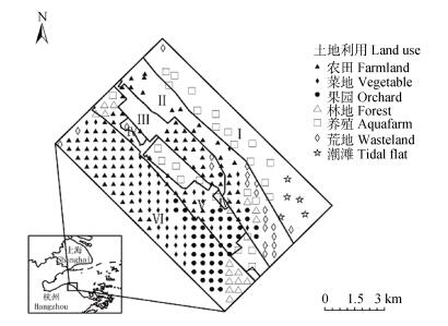
图1研究区地理位置及土地利用情况
Figure1.Geographical location and land use types of the study area
 下载: 全尺寸图片幻灯片
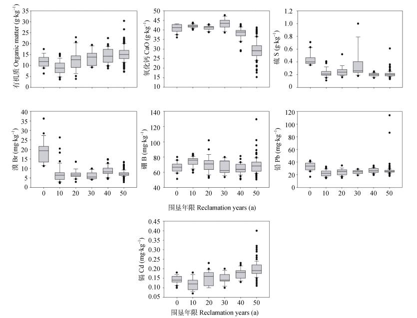
图2最小数据集参数在不同围垦年限下的土壤化学性质特征图
Figure2.Chemical characteristics of soil under different reclamation years in the minimum data set
下载: 全尺寸图片幻灯片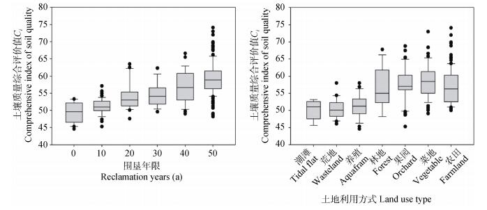
图3不同围垦年限和利用方式下研究区土壤质量综合评价值
Figure3.Comprehensive indexes of soil quality under different reclamation years and land use types in the study area
下载: 全尺寸图片幻灯片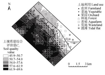
图4研究区土壤质量分布情况
Figure4.Distribution of soil quality in the study area
下载: 全尺寸图片幻灯片表1研究区土地利用及采样点分布情况
Table1.Land use and distribution of soil samples in the study area
| 样点编号 Sample number | 样点数 Amount of samples | 海堤修筑年份 Year for building dams | 围垦年限 Reclamation years (a) |
| Ⅰ | 21 | 未围垦Tidal flat | 0 |
| Ⅱ | 49 | 2002—2012 | 10 |
| Ⅲ | 25 | 1990—2002 | 20 |
| Ⅳ | 13 | 1980—1990 | 30 |
| Ⅴ | 35 | 1970—1980 | 40 |
| Ⅵ | 133 | —1970 | 50 |
下载: 导出CSV表2各土壤因子综合得分及土壤质量评价最小数据集确定
Table2.Scoring of soil parameters and determining of minimum data set for soil quality assessment
| 土壤因子 Soil parameter | 分组 Group | 初始分值Initial value | 线性变换Linear transformation | 综合得分 Scoring | |||||
| Norm值 Norm value | 调整R2 Adjusted R2 | T | Norm值 Norm value | 调整R2 Adjusted R2 | T | ||||
| 粉粒/黏粒 Silt/clay | 1 | 2.136 | 0.158 | 4 | 0.685 | 0.213 | 0.25 | 1.147 | |
| K2O | 1 | 3.092 | 0.291 | 5 | 0.991 | 0.391 | 0.20 | 1.583 | |
| Al2O3 | 1 | 3.120 | 0.338 | 3 | 1.000 | 0.455 | 0.33 | 1.788 | |
| Fe2O3 | 1 | 3.120 | 0.332 | 5 | 1.000 | 0.447 | 0.20 | 1.647 | |
| Mn | 1 | 3.020 | 0.292 | 5 | 0.968 | 0.393 | 0.20 | 1.561 | |
| Cu | 1 | 2.800 | 0.189 | 5 | 0.897 | 0.254 | 0.20 | 1.352 | |
| Zn | 1 | 2.805 | 0.183 | 6 | 0.899 | 0.246 | 0.17 | 1.312 | |
| Pb | 1 | 2.314 | 0.057 | 1 | 0.741 | 0.077 | 1.00 | 1.818 | |
| As | 1 | 2.700 | 0.283 | 5 | 0.865 | 0.381 | 0.20 | 1.446 | |
| Cr | 1 | 3.022 | 0.332 | 5 | 0.968 | 0.447 | 0.20 | 1.615 | |
| pH | 2 | 1.869 | 0.516 | 4 | 0.599 | 0.695 | 0.25 | 1.543 | |
| P | 2 | 1.992 | 0.458 | 4 | 0.638 | 0.616 | 0.25 | 1.505 | |
| CaO | 2 | 2.040 | 0.743 | 5 | 0.654 | 1.000 | 0.20 | 1.854 | |
| Cd | 2 | 2.289 | 0.477 | 1 | 0.734 | 0.642 | 1.00 | 2.376 | |
| Hg | 2 | 1.758 | 0.223 | 6 | 0.563 | 0.300 | 0.17 | 1.030 | |
| S | 3 | 1.731 | 0.457 | 3 | 0.555 | 0.615 | 0.33 | 1.503 | |
| B | 4 | 1.022 | 0.1 | 2 | 0.327 | 0.135 | 0.50 | 0.962 | |
| 有机质 Organic matter | 5 | 2.319 | 0.333 | 1 | 0.743 | 0.448 | 1.00 | 2.191 | |
| N | 5 | 2.326 | 0.338 | 4 | 0.745 | 0.455 | 0.25 | 1.450 | |
| Na2O | 5 | 2.481 | 0.388 | 3 | 0.795 | 0.522 | 0.33 | 1.651 | |
| MgO | 5 | 2.702 | 0.585 | 5 | 0.866 | 0.787 | 0.20 | 1.853 | |
| SiO2 | 5 | 2.942 | 0.466 | 4 | 0.943 | 0.627 | 0.25 | 1.820 | |
| Cl | 5 | 1.967 | 0.721 | 2 | 0.630 | 0.970 | 0.50 | 2.101 | |
| Br | 5 | 2.123 | 0.543 | 5 | 0.680 | 0.731 | 0.20 | 1.611 | |
下载: 导出CSV表3研究区土壤质量评价体系
Table3.Evaluation system of soil quality in the study area
| 目标层 Target layer | 准则层 Criterion layer | 指标层 Factor layer | 权重 Weight | 属性 Attribute | 适中值 Modest value (mg·kg-1) |
| 土壤质量 Soil quality | 肥力Fertility | 有机质Organic matter | 0.338 | 正Positive | — |
| 常、微量 Macro-element and micro-element | CaO | 0.194 | 适中Modest | 1 530 | |
| S | 0.082 | 适中Modest | 176 | ||
| Br | 0.097 | 适中Modest | 6.25 | ||
| B | 0.059 | 适中Modest | 63 | ||
| 重金属 Heavy mental | Pb | 0.070 | 逆Inverse | — | |
| Cd | 0.160 | 逆Inverse | — |
下载: 导出CSV表4研究区不同土地利用方式下各土壤因子对土壤质量指标的障碍度
Table4.Limiting degrees of soil parameters to soil quality indexes for different land use types in the study area
| 土地利用方式Land use type | 有机质 Organic matter | CaO | S | Br | B | Pb | Cd |
| 滩涂Tidal flat | 0.163 | 0.056 | 0.010 | 0.022 | 0.001 | 0.003 | 0.009 |
| 围垦10 a Reclamation for 10 a | 0.223 | 0.061 | 0.002 | 0.003 | 0.002 | 0.001 | 0.005 |
| 围垦20 a Reclamation for 20 a | 0.166 | 0.057 | 0.002 | 0.002 | 0.002 | 0.001 | 0.011 |
| 围垦30 a Reclamation for 30 a | 0.139 | 0.068 | 0.008 | 0.001 | 0.001 | 0.001 | 0.010 |
| 围垦40 a Reclamation for 40 a | 0.124 | 0.045 | 0.001 | 0.004 | 0.001 | 0.001 | 0.017 |
| 围垦50 a Reclamation for 50 a | 0.115 | 0.019 | 0.001 | 0.002 | 0.002 | 0.002 | 0.026 |
| 水田Paddy field | 0.188 | 0.06 | 0.004 | 0.005 | 0.002 | 0.001 | 0.008 |
| 旱地Dry land | 0.117 | 0.027 | 0.001 | 0.003 | 0.001 | 0.002 | 0.025 |
| 整体Total | 0.145 | 0.038 | 0.002 | 0.004 | 0.002 | 0.001 | 0.018 |
下载: 导出CSV参考文献
| [1] | 许艳, 濮励杰.江苏海岸带滩涂围垦区土地利用类型变化研究——以江苏省如东县为例[J].自然资源学报, 2014, 29(4):643-652 doi: 10.11849/zrzyxb.2014.04.009 XU Y, PU L J. The variation of land use pattern in tidal flat reclamation zones in Jiangsu coastal area:A case study of Rudong County of Jiangsu Province[J]. Journal of Natural Resources, 2014, 29(4):643-652 doi: 10.11849/zrzyxb.2014.04.009 |
| [2] | 赵海迪, 刘世梁, 董世魁, 等.三江源区人类干扰与湿地空间变化关系研究[J].湿地科学, 2014, 12(1):22-28 https://www.researchgate.net/publication/303408559_sanjiangyuanqurenleiganraoyushidekongjianbianhuaguanxiyanjiu ZHAO H D, LIU S L, DONG S K, et al. Relationship between human interference and wetland spatial variation in Three-River Headwaters Region[J]. Wetland Science, 2014, 12(1):22-28 https://www.researchgate.net/publication/303408559_sanjiangyuanqurenleiganraoyushidekongjianbianhuaguanxiyanjiu |
| [3] | 王琪琪, 濮励杰, 朱明, 等.沿海滩涂围垦区土壤质量演变研究——以江苏省如东县为例[J].地理科学, 2016, 36(2):256-264 https://www.cnki.com.cn/qikan-DLKX201602012.html WANG Q Q, PU L J, ZHU M, et al. Soil quality evolution in coastal reclamation zones:A case study of Rudong County of Jiangsu Province[J]. Scientia Geographica Sinica, 2016, 36(2):256-264 https://www.cnki.com.cn/qikan-DLKX201602012.html |
| [4] | KARLEN D L, ANDREWS S S, DORAN J W. Soil quality:Current concepts and applications[J]. Advances in Agronomy, 2001, 74:1-40 doi: 10.1016/S0065-2113(01)74029-1 |
| [5] | 张贞, 魏朝富, 高明, 等.土壤质量评价方法进展[J].土壤通报, 2006, 37(5):999-1006 doi: 10.3969/j.issn.1004-6429.2014.05.025 ZHANG Z, WEI C F, GAO M, et al. Assessment methods for soil quality:A review[J]. Chinese Journal of Soil Science, 2006, 37(5):999-1006 doi: 10.3969/j.issn.1004-6429.2014.05.025 |
| [6] | 张心昱, 陈利顶.土壤质量评价指标体系与评价方法研究进展与展望[J].水土保持研究, 2006, 13(3):30-34 https://www.wenkuxiazai.com/doc/d4b4e0ed5ef7ba0d4a733b2c.html ZHANG X Y, CHEN L D. The progress and prospect of soil quality indicators and evaluation methods[J]. Research of Soil and Water Conservation, 2006, 13(3):30-34 https://www.wenkuxiazai.com/doc/d4b4e0ed5ef7ba0d4a733b2c.html |
| [7] | 刘世梁, 傅伯杰, 刘国华, 等.我国土壤质量及其评价研究的进展[J].土壤通报, 2006, 37(1):137-143 https://www.researchgate.net/publication/303408569_woguoturangzhiliangjiqipingjiayanjiudejinzhan LIU S L, FU B J, LIU G H, et al. Research review of quantitative evaluation of soil quality in China[J]. Chinese Journal of Soil Science, 2006, 37(1):137-143 https://www.researchgate.net/publication/303408569_woguoturangzhiliangjiqipingjiayanjiudejinzhan |
| [8] | 许明祥, 刘国彬, 赵允格.黄土丘陵区侵蚀土壤质量评价[J].植物营养与肥料学报, 2005, 11(3):285-293 doi: 10.11674/zwyf.2005.0301 XU M X, LIU G B, ZHAO Y G. Quality assessment of erosion soil on hilly Loess Plateau[J]. Plant Nutrition and Fertilizer Science, 2005, 11(3):285-293 doi: 10.11674/zwyf.2005.0301 |
| [9] | 黄婷, 岳西杰, 葛玺祖, 等.基于主成分分析的黄土沟壑区土壤肥力质量评价——以长武县耕地土壤为例[J].干旱地区农业研究, 2010, 28(3):141-147 https://www.wenkuxiazai.com/doc/aea605cdda38376baf1faecd-4.html HUANG T, YUE X J, GE X Z, et al. Evaluation of soil quality on gully region of Loess Plateau based on principal component analysis[J]. Agricultural Research in the Arid Areas, 2010, 28(3):141-147 https://www.wenkuxiazai.com/doc/aea605cdda38376baf1faecd-4.html |
| [10] | 姚荣江, 杨劲松, 陈小兵, 等.苏北海涂围垦区土壤质量模糊综合评价[J].中国农业科学, 2009, 42(6):2019-2027 https://www.wenkuxiazai.com/doc/9815dcc089eb172ded63b743.html YAO R J, YANG J S, CHEN X B, et al. Fuzzy synthetic evaluation of soil quality in coastal reclamation region of North Jiangsu Province[J]. Scientia Agricultura Sinica, 2009, 42(6):2019-2027 https://www.wenkuxiazai.com/doc/9815dcc089eb172ded63b743.html |
| [11] | ANDREWS S S, KARLEN D L, MITCHELL J P. A comparison of soil quality indexing methods for vegetable production systems in Northern California[J]. Agriculture, Ecosystems & Environment, 2002, 90(1):25-45 https://www.researchgate.net/publication/228508704_A_Comparison_of_Soil_Quality_Indexing_Methods_for_Vegetable_Production_Systems_in_Northern_California |
| [12] | YEMEFACK M, JETTEN V G, ROSSITER D G. Developing a minimum data set for characterizing soil dynamics in shifting cultivation systems[J]. Soil and Tillage Research, 2006, 86(1):84-98 doi: 10.1016/j.still.2005.02.017 |
| [13] | 李桂林, 陈杰, 檀满枝, 等.基于土地利用变化建立土壤质量评价最小数据集[J].土壤学报, 2008, 45(1):16-25 doi: 10.11766/trxb200610020103 LI G L, CHEN J, TAN M Z, et al. Establishment of a minimum dataset for soil quality assessment based on land use change[J]. Acta Pedologica Sinica, 2008, 45(1):16-25 doi: 10.11766/trxb200610020103 |
| [14] | 李桂林, 陈杰, 孙志英, 等.基于土壤特征和土地利用变化的土壤质量评价最小数据集确定[J].生态学报, 2007, 27(7):2715-2724 https://www.wenkuxiazai.com/doc/a8ca7ef8910ef12d2af9e74b.html LI G L, CHEN J, SUN Z Y, et al. Establishing a minimum dataset for soil quality assessment based on soil properties and land use change[J]. Acta Ecologica Sinica, 2007, 27(7):2715-2724 https://www.wenkuxiazai.com/doc/a8ca7ef8910ef12d2af9e74b.html |
| [15] | 贡璐, 张雪妮, 冉启洋.基于最小数据集的塔里木河上游绿洲土壤质量评价[J].土壤学报, 2015, 52(3):682-689 http://or.nsfc.gov.cn/handle/00001903-5/38369 GONG L, ZHANG X N, RAN Q Y. Quality assessment of oasis soil in the upper reaches of Tarim River based on minimum data set[J]. Acta Pedologica Sinica, 2015, 52(3):682-689 http://or.nsfc.gov.cn/handle/00001903-5/38369 |
| [16] | 邓绍欢, 曾令涛, 关强, 等.基于最小数据集的南方地区冷浸田土壤质量评价[J].土壤学报, 2016, 53(5):1326-1333 http://mall.cnki.net/magazine/magadetail/TRXB201605.htm DENG S H, ZENG L T, GUAN Q, et al. Minimum dataset-based soil quality assessment of waterlogged paddy field in South China[J]. Acta Pedologica Sinica, 2016, 53(5):1326-1333 http://mall.cnki.net/magazine/magadetail/TRXB201605.htm |
| [17] | 岳西杰, 葛玺祖, 王旭东.基于GIS的黄土丘陵沟壑区土壤质量评价研究——以陕西省长武县为例[J].干旱地区农业研究, 2011, 29(3):144-149 http://www.cjae.net/CN/abstract/abstract20347.shtml YUE X J, GE X Z, WANG X D. GIS-based research on soil quality evaluation in the Loess Hilly Gully region-A case study of Changwu County[J]. Agricultural Research in the Arid Areas, 2011, 29(3):144-149 http://www.cjae.net/CN/abstract/abstract20347.shtml |
| [18] | 高宇, 赵斌.人类围垦活动对上海崇明东滩滩涂发育的影响[J].中国农学通报, 2006, 22(8):475-479 https://mall.cnki.net/qikan-STXB200811062.html GAO Y, ZHAO B. The effect of reclamation on mud flat development in Chongming Island, Shanghai[J]. Chinese Agricultural Science Bulletin, 2006, 22(8):475-479 https://mall.cnki.net/qikan-STXB200811062.html |
| [19] | 张徐, 张明, 吴鹏豹, 等.典型滩涂围垦区土壤化学性质的短期变化特征[J].土壤通报, 2016, 47(2):346-352 http://mall.cnki.net/magazine/Article/TRTB201602025.htm ZHANG X, ZHANG M, WU P B, et al. Short-term variation of soil chemical properties after tidal flat reclamation in a typical coastal area[J]. Chinese Journal of Soil Science, 2016, 47(2):346-352 http://mall.cnki.net/magazine/Article/TRTB201602025.htm |
| [20] | 张明, 陈国光, 高超, 等.华东多目标区域地球化学调查区土壤常量元素地球化学特征[J].吉林大学学报:地球科学版, 2014, 44(3):995-1002 doi: 10.13278/j.cnki.jjuese.201403210.html ZHANG M, CHEN G G, GAO C, et al. Geochemical characteristics of macro elements in soils in the region covered by multi-purpose geochemical survey in eastern China[J]. Journal of Jilin University:Earth Science Edition, 2014, 44(3):995-1002 doi: 10.13278/j.cnki.jjuese.201403210.html |
| [21] | 张先起, 梁川, 刘慧卿.基于熵权的改进TOPSIS法在水质评价中的应用[J].哈尔滨工业大学学报, 2007, 39(10):1670-1672 doi: 10.3321/j.issn:0367-6234.2007.10.038 ZHANG X Q, LIANG C, LIU H Q. Application of improved TOPSIS method based on coefficient of entropy to comprehensive evaluating water quality[J]. Journal of Harbin Institute of Technology, 2007, 39(10):1670-1672 doi: 10.3321/j.issn:0367-6234.2007.10.038 |
| [22] | 刘明宇, 华珞, 王世岩, 等.基于改进TOPSIS方法的温榆河水环境质量综合评价研究[J].南水北调与水利科技, 2007, 5(3):57-60 http://www.cnki.com.cn/Article/CJFDTOTAL-XTLL200401020.htm LIU M Y, HUA L, WANG S Y, et al. Comprehensive evaluation on water environment quality in the Wenyu River by improved TOPSIS[J]. South-to-North Water Transfers and Water Science & Technology, 2007, 5(3):57-60 http://www.cnki.com.cn/Article/CJFDTOTAL-XTLL200401020.htm |
| [23] | 刘文新, 栾兆坤, 汤鸿霄.乐安江沉积物中金属污染的潜在生态风险评价[J].生态学报, 1999, 19(2):206-211 https://www.wenkuxiazai.com/doc/634e1b24284ac850ac02420b-2.html LIU W X, LUAN Z K, TANG H X. Environmental assessment on heavy metal pollution in the sediments of Le'an River with potential ecological risk index[J]. Acta Ecologica Sinica, 1999, 19(2):206-211 https://www.wenkuxiazai.com/doc/634e1b24284ac850ac02420b-2.html |
| [24] | 陈宁丽, 张红方, 张合兵, 等.基于熵权TOPSIS法的耕地生态质量空间分布格局及主控因子分析——以河南省新郑市为例[J].浙江农业学报, 2015, 27(8):1444-1450 https://wuxizazhi.cnki.net/qikan-ZJNB201508024.html CHEN N L, ZHANG H F, ZHANG H B, et al. Spatial distribution and dominating factors analysis of ecological quality of cultivated land based on entropy-weighting TOPSIS method:A case study of Xinzheng City, Henan Province[J]. Acta Agriculturae Zhejiangensis, 2015, 27(8):1444-1450 https://wuxizazhi.cnki.net/qikan-ZJNB201508024.html |
| [25] | 陈伯扬. TOPSIS法在土壤环境质量评价中的应用[J].现代地质, 2008, 22(6):1003-1009 https://www.cnki.com.cn/qikan-DZHB902.001.html CHEN B Y. Application of TOPSIS method to the environment quality evaluation of soil[J]. Geoscience, 2008, 22(6):1003-1009 https://www.cnki.com.cn/qikan-DZHB902.001.html |
| [26] | ZHANG H, WU P B, YIN A J, et al. Prediction of soil organic carbon in an intensively managed reclamation zone of eastern China:A comparison of multiple linear regressions and the random forest model[J]. Science of the Total Environment, 2017, 592:704-713 doi: 10.1016/j.scitotenv.2017.02.146 |
| [27] | 吴乐知, 蔡祖聪.中国土壤有机质含量变异性与空间尺度的关系[J].地球科学进展, 2006, 21(9):965-972 https://www.wenkuxiazai.com/doc/66e12c060740be1e650e9ae1.html WU L Z, CAI Z C. The relationship between the spatial scale and the variation of soil organic matter in China[J]. Advances in Earth Science, 2006, 21(9):965-972 https://www.wenkuxiazai.com/doc/66e12c060740be1e650e9ae1.html |
| [28] | 环境保护局, 国家质量监督检验检疫总局. GB 15618-2008土壤环境质量标准[S]. 北京: 中国标准出版社, 2008 Environmental Protection Agency, General Administration of Quality Supervision, Inspection and Quarantine. GB 15618-2008 Environmental Quality Standard for Soils[S]. Beijing: China Standards Press, 2008 |
| [29] | 魏复盛, 杨国治, 蒋德珍, 等.中国土壤元素背景值基本统计量及其特征[J].中国环境监测, 1991, 7(1):1-6 https://www.wenkuxiazai.com/doc/f38c854dec3a87c24128c44f.html WEI F S, YANG G Z, JIANG D Z, et al. Statistics and characteristic in background value of soil elements in China[J]. Environmental Monitoring in China, 1991, 7(1):1-6 https://www.wenkuxiazai.com/doc/f38c854dec3a87c24128c44f.html |
| [30] | 范允慧, 王艳青.浙江省四大平原区土壤元素背景值特征[J].物探与化探, 2009, 33(2):132-134 FAN Y H, WANG Y Q. Background characteristics of soil elements in four plains of Zhejiang Province[J]. Geophysical & Geochemical Exploration, 2009, 33(2):132-134 |
