金佳2,
徐飞飞2,
冯险峰2,
罗明2,
毕雷雷1,
陆洲2,,
1.苏州市林业站 苏州 215128
2.中国科学院地理科学与资源研究所 北京 100101
基金项目: 国家重点研发计划项目2016YFD0300201
江苏省农业科技自主创新资金项目CX(16)1042
苏州市科技计划项目SNG201643
苏州市科技计划项目SNG2018100
详细信息
作者简介:姚新华, 主要从事森林经理学及3S林业应用技术研究。E-mail:1304659769@qq.com
通讯作者:陆洲, 主要从事农业遥感应用研究。E-mail:luzhou@igsnrr.ac.cn
中图分类号:S127计量
文章访问数:521
HTML全文浏览量:16
PDF下载量:474
被引次数:0
出版历程
收稿日期:2018-10-30
录用日期:2019-03-28
刊出日期:2019-10-01
Research on spectral and texture feature selection for fruit tree extraction in the Taihu Lake Basin
YAO Xinhua1,,JIN Jia2,
XU Feifei2,
FENG Xianfeng2,
LUO Ming2,
BI Leilei1,
LU Zhou2,,
1. Suzhou Forestry Station, Suzhou 215128, China
2. Institute of Geographic Sciences and Natural Resources Research, Chinese Academy of Sciences, Beijing 100101, China
Funds: This study was supported by the National Key R & D Program of China2016YFD0300201
the Jiangsu Agricultural Science and Technology Innovation FundCX(16)1042
the Suzhou Science and Technology ProjectSNG201643
the Suzhou Science and Technology ProjectSNG2018100
More Information
Corresponding author:LU Zhou, E-mail: luzhou@igsnrr.ac.cn
摘要
HTML全文
图
参考文献
相关文章
施引文献
资源附件
访问统计
摘要
摘要:准确获取果树的空间种植分布信息,对于开展果树长势监测、产量估算等具有重要意义。为提取太湖流域金庭镇果树的空间分布,本研究以冬夏时期的两景高分二号(GF-2)遥感影像为数据源,利用归一化植被指数(NDVI)和归一化水体指数(NDWI)结合纹理特征构建了基于光谱指数和纹理特征的决策树模型,提取了金庭镇2017年果树的空间分布信息。通过分析研究区各地类的光谱曲线发现,植被与非植被区分明显,但果树与茶树的光谱存在混淆。GF-2影像包含丰富的纹理信息,果树与茶树在GF-2影像上纹理特征明显,易于区分。纹理可作为果树提取的重要特征。为了确定最佳纹理窗口的大小,研究中提出了累计差(Δf)的方法。通过比较每一个纹理变量在15种不同尺度窗口(3×3,5×5,7×7,9×9,11×11,13×13,15×15,17×17,19×19,21×21,23×23,25×25,27×27,29×29,31×31)下的Δf,确定了最佳纹理窗口为15×15。在最佳纹理窗口下根据累计差选取了5大纹理组合:均值(mean)、方差(variance)、对比度(contrast)、信息熵(entropy)和相关性(correlation)。研究结果表明基于光谱指数NDVI和NDWI结合纹理特征构建的决策树模型可有效区分果树与茶树。累计差的方法能够快速确定最佳纹理窗口和纹理组合。提取结果说明果树分布于金庭镇的各个位置,主要分布在平原区,种植比较整齐,南部种植面积多于北部。本研究果树的提取精度为95.23%,模型总体分类精度为89.57%,Kappa系数为89.00%,果树的生产精度为90.00%,用户精度为87.30%。与单一光谱、纹理模型相比,本文模型总体分类精度更高,精度分别提升了10.65%和12.04%。该方法能够适用于大区域果树的遥感提取,可为亚米级遥感影像研究果树的纹理特征提供重要参考和借鉴价值。此外,文中提出的累计差可为选取最佳纹理窗口提供一种新的思路。
关键词:GF-2影像/
果树提取/
光谱特征/
纹理特征/
决策树分类
Abstract:The accurate acquisition of planting area and spatial distribution information is essential to monitor the growth and estimate the production of fruit trees (orchard). Remote sensing has been widely used in crop identification and monitoring in recent decades. Numerous classification algorithms have been developed based on various requirements for remote sensing data analysis. However, distinguishing fruit tree orchard and tea garden remains challenging, due to their similar spectral characteristics. Two GF-2 WFV (wide field of view) images, taken in summer and winter, were used to extract the spatial distribution of fruit trees in Jinting Town in the Taihu Lake Basin in this study. The normalized difference vegetation index (NDVI), normalized difference water index (NDWI), and texture features were used to construct a decision tree model. Vegetation and non-vegetation were quickly identified by analyzing the spectral curves of ground features in the study area. However, spectral characteristic was a poor parameter to differentiate fruit trees from tea trees. Since fruit trees and tea trees have distinct textural features, GF-2 images with rich texture information on ground objects can help distinguish fruit trees from tea trees. Thus, texture is one of the most important features in fruit tree extraction. In this study, the method of cumulative difference (Δf) was used to determine the optimal size of the texture window. Among the Δf values of each texture under 15 different window scales (3×3, 5×5, 7×7, 9×9, 11×11, 13×13, 15×15, 17×17, 19×19, 21×21, 23×23, 25×25, 27×27, 29×29, 31×31), the 15×15 window was determined as the optimum texture window. In addition, five texture features that were easy to distinguish from other objects were selected according to the cumulative difference of variables such as mean, variance, contrast, entropy, and correlation under the optimal texture window. The results showed that the decision tree model based on spectral index NDVI and NDWI, combined with texture features, effectively distinguished fruit trees from tea trees. The method of cumulative difference can quickly determine the best texture window size and texture combination. The extraction results showed that fruit trees were widely distributed in all locations of Jinting Town and that the planting area in the south was larger than that in the north. The local detail map indicated that the distribution of fruit trees was relatively neat and mainly in the plain area. The extraction accuracy of fruit trees in this study was 95.23%. The overall accuracy of the model in this study was 89.57% and the kappa coefficient was 89.00%. The producer accuracy and user accuracy were 90.00% and 87.30%, respectively. Using spectral indices combined with textural features achieved a higher overall accuracy than using spectral indices or textural features alone, with an overall accuracy increase of 10.65% and 12.04%, respectively. This method can be applied to the remote sensing extraction of fruit trees on a large scale and can provide an important reference in fruit tree extraction by using texture characteristics of sub-meter images. Moreover, the cumulative difference proposed in this study provides a new method for selecting the best texture window.
Key words:GF-2 images/
Fruit tree extraction/
Spectral features/
Textural features/
Decision tree classification
HTML全文
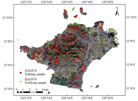
图1金庭镇位置示意及训练样本和验证样本的分布
Figure1.Location of Jinting Town and distribution of training samples and verifying samples
 下载: 全尺寸图片幻灯片
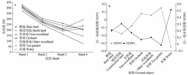
图2研究区内各主要地物光谱曲线(a)与光谱指数(b)
Figure2.Spectral curves (a) and spectral indices (b) of main ground objects in the study area
DN: digital number; NDVI: normalized vegetation index; NDWI: normalized water index.
下载: 全尺寸图片幻灯片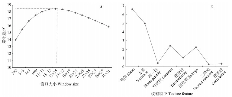
图3不同窗口下累计差(a)与最佳窗口15x15下各纹理变量的累计差(b)
Figure3.Accumulated differences under different windows (a) and the accumulated difference of each texture variable under the optimal window 15x15 (b)
下载: 全尺寸图片幻灯片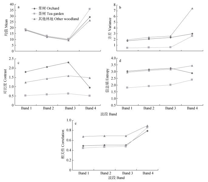
图4不同波段下果树、茶树、其他林地的均值(a)、方差(b)、对比度(c)、信息熵(d)、相关性(e)的变化
Figure4.Changes of mean (a), variance (b), contrast (c), entropy (d), and correlation (e) of fruit, tea and other woodland under different wavebands
下载: 全尺寸图片幻灯片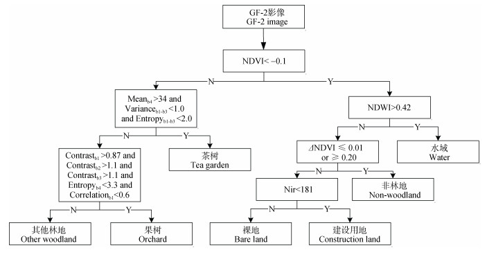
图5基于光谱和纹理特征的金庭镇果树提取流程图
Meanb4: Band4的均值; Varianceb1-b3: Band1至Band3的方差; Entropyb1-b3: Band1至Band3的熵; Contrastb1、Contrastb2、Contrastb3: Band1、Band2、Band3的对比度; Entropyb4: Band4的熵; Correlationb1: Band1的相关性。NDVI:归一化植被指数; NDWI:归一化水体指数; ΔNDVI: 2017年12月17日与2017年8月5日的NDVI图像差值; Nir: Band4的灰度值。Meanb4: mean of Band4; Varianceb1-b3: variance of Band1 to Band3; Entropyb1-b3: entropy of Band1 to Band3; Contrastb1, Contrastb2, Contrastb3: contrast of Band1, Band2 and Band3, respectively; Entropyb4: entropy of Band4; Correlationb1: correlation of Band1; NDVI: normalized vegetation index; NDWI: normalized water index; ΔNDVI: the difference between the NDVI images of December 17, 2017 and August 5, 2017; Nir: the digital number (DN) of Band4.
Figure5.Flow chart of fruit tree extraction in Jinting Town based on spectral and texture features
下载: 全尺寸图片幻灯片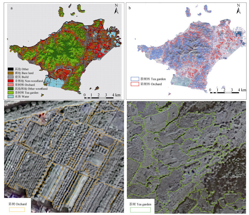
图6金庭镇地物分类结果(a)、果树林和茶树林的提取结果(b)、果树局部提取结果(c)和茶树局部提取结果(d)
Figure6.Classification results of ground objects (a), extraction results of fruit trees and tea trees (b), local extraction results of fruit trees (c) and local extraction results of tea trees (d) in Jinting Town
下载: 全尺寸图片幻灯片表1GF-2卫星影像数据参数
Table1.GF-2 satellite image data parameters
| GF-2波段 GF-2 band | 光谱波段 Wavelength (μm) | 空间分辨率 Resolution (m) |
| Band1 | 0.45~0.52 | 3.24 |
| Band2 | 0.52~0.59 | 3.24 |
| Band3 | 0.63~0.69 | 3.24 |
| Band4 | 0.77~0.89 | 3.24 |
| Band5 | 0.45~0.90 | 0.81 |
下载: 导出CSV表2研究区地类解译标志
Table2.Interpretation symbols of land-use types in the study area
| 影像特征及解译标志 Image characteristics and interpretation indicator | GF-2影像 GF-2 image |
| 水体:几何形状明显, 边界清晰, 呈多边形, 颜色为蓝绿色 Water: clear geometry and clear boundary with polygon and blue-green color |  |
| 建设用地:成片分布, 颜色呈灰黑色或蓝、红色 Construction land: distributed in patches with gray-black or blue or red colors |  |
| 裸地:分布较少, 颜色为褐色 Bare land: less distributed, brown color |  |
| 其他林地:形状不规则, 密集分布, 呈墨绿色 Other woodlands: irregular shape and dense distribution with dark green |  |
| 非林地:纹理结构清晰, 呈褐色或浅绿色 Non-woodland: clear texture structure with brown or light green |  |
| 果树:纹理结构清晰, 颗粒感强, 规则片状分布, 呈深绿色 Orchard: clear texture structure, strong granular sense and regular sheet distribution with dark green |  |
| 茶树:条带状分布, 纹理结构较为清晰, 呈翠绿色 Tea: striped distribution, and much clear texture structure with emerald green |  |
下载: 导出CSV表3本文模型与单一光谱和纹理模型的分类结果对比
Table3.Comparisons of classification results between the established model in this study and single spectral and single texture models
| 分类方法 Classification method | 总体分类精度 Overall classification accuracy (%) | Kappa系数 Kappa coefficient | 果树生产精度 Producer accuracy (%) | 果树漏分误差 Commission error (%) | 果树用户精度 User accuracy (%) | 果树错分误差 Omission error (%) |
| 本文模型 This study | 89.57 | 89.00 | 90.00 | 10.10 | 87.30 | 12.70 |
| 纹理特征模型 Texture feature model | 77.53 | 73.00 | 75.00 | 24.90 | 78.00 | 22.50 |
| 光谱特征模型 Spectral characteristic model | 78.92 | 74.00 | 74.00 | 25.60 | 72.00 | 27.90 |
下载: 导出CSV参考文献
| [1] | 罗卫, 况润元.利用环境卫星影像的东江源地区果园信息提取[J].测绘科学, 2014, 39(8):135-139 http://d.old.wanfangdata.com.cn/Periodical/chkx201408030 LUO W, KUANG R Y. Orchard information extraction of Dongjiang Source region with HJ satellite data[J]. Science of Surveying and Mapping, 2014, 39(8):135-139 http://d.old.wanfangdata.com.cn/Periodical/chkx201408030 |
| [2] | 邢东兴, 常庆瑞.基于花期果树冠层光谱反射率的果树树种辨识研究[J].红外与毫米波学报, 2009, 28(3):207-211 doi: 10.3321/j.issn:1001-9014.2009.03.012 XING D X, CHANG Q R. Identification of species of fruit trees based on the spectral reflectance of canopies of fruit trees during flowering period[J]. Journal of Infrared and Millimeter Waves, 2009, 28(3):207-211 doi: 10.3321/j.issn:1001-9014.2009.03.012 |
| [3] | 李雪, 钟仕全, 王蕾, 等.基于HJ卫星遥感数据的林果光谱特征分析[J].新疆农业科学, 2011, 48(11):1967-1973 doi: 10.6048/j.issn.1001-4330.2011.11.002 LI X, ZHONG S Q, WANG L, et al. Analysis of spectral characteristics of fruit trees based on HJ satellite remote sensing data[J]. Xinjiang Agricultural Sciences, 2011, 48(11):1967-1973 doi: 10.6048/j.issn.1001-4330.2011.11.002 |
| [4] | ZHOU J H, QIN J, GAO K, et al. SVM-based soft classification of urban tree species using very high-spatial resolution remote-sensing imagery[J]. International Journal of Remote Sensing, 2016, 37(11):2541-2559 doi: 10.1080/01431161.2016.1178867 |
| [5] | IMMITZER M, ATZBERGER C, KOUKAL T. Tree species classification with random forest using very high spatial resolution 8-band worldview-2 satellite data[J]. Remote Sensing, 2012, 4(9):2661-2693 doi: 10.3390/rs4092661 |
| [6] | PE?A M A, BRENNING A. Assessing fruit-tree crop classification from Landsat-8 time series for the Maipo Valley, Chile[J]. Remote Sensing of Environment, 2015, 171:234-244 doi: 10.1016/j.rse.2015.10.029 |
| [7] | PE?A M A, LIAO R, BRENNING A. Using spectrotemporal indices to improve the fruit-tree crop classification accuracy[J]. ISPRS Journal of Photogrammetry and Remote Sensing, 2017, 128:158-169 doi: 10.1016/j.isprsjprs.2017.03.019 |
| [8] | KULIKOVA M S, MANI M, SRIVASTAVA A, et al. Tree species classification using radiometry, texture and shape based features[C]//Proceedings of the 15th European Signal Processing Conference. Poznan, Poland: IEEE https://www.researchgate.net/publication/42325434_TREE_SPECIES_CLASSIFICATION_USING_RADIOMETRY_TEXTURE_AND_SHAPE_BASED_FEATURES |
| [9] | OTHMANI A, PIBOULE A, DALMAU O, et al. Tree species classification based on 3D bark texture analysis[C]//Proceedings of the 6th Pacific-Rim Symposium on Image and Video Technology. Guanajuato, Mexico: Springer, 2013 https://www.researchgate.net/publication/263272525_Tree_Species_Classification_Based_on_3D_Bark_Texture_Analysis?ev=auth_pub |
| [10] | 岳俊, 王振锡, 冯振峰, 等.基于光谱与纹理特征的南疆盆地果树树种遥感识别研究[J].新疆农业大学学报, 2015, 38(4):326-333 doi: 10.3969/j.issn.1007-8614.2015.04.014 YUE J, WANG Z X, FENG Z F, et al. Studies on remote sensing recognition on fruit trees species based on spectrum and texture features in southern Xinjiang Basin[J]. Journal of Xinjiang Agricultural University, 2015, 38(4):326-333 doi: 10.3969/j.issn.1007-8614.2015.04.014 |
| [11] | PU R L, LANDRY S. A comparative analysis of high spatial resolution IKONOS and WorldView-2 imagery for mapping urban tree species[J]. Remote Sensing of Environment, 2012, 124:516-533 doi: 10.1016/j.rse.2012.06.011 |
| [12] | DIAN Y Y, LI Z Y, PANG Y. Spectral and texture features combined for forest tree species classification with airborne hyperspectral imagery[J]. Journal of the Indian Society of Remote Sensing, 2015, 43(1):101-107 doi: 10.1007/s12524-014-0392-6 |
| [13] | 宋荣杰, 宁纪锋, 常庆瑞, 等.基于小波纹理和随机森林的猕猴桃果园遥感提取[J].农业机械学报, 2018, 49(4):222-231 http://d.old.wanfangdata.com.cn/Periodical/nyjxxb201804025 SONG R J, NING J F, CHANG Q R, et al. Kiwifruit orchard mapping based on wavelet textures and random forest[J]. Transactions of The Chinese Society for Agricultural Machinery, 2018, 49(4):222-231 http://d.old.wanfangdata.com.cn/Periodical/nyjxxb201804025 |
| [14] | 郝剑南, 王瑞红.纹理特征与面向对象结合的高分影像耕地提取应用[J].安徽农业科学, 2018, 46(19):72-75 doi: 10.3969/j.issn.0517-6611.2018.19.022 HAO J N, WANG R H. Application of high-resolution image farmland extraction combining texture feature and object-oriented[J]. Journal of Anhui Agricultural Sciences, 2018, 46(19):72-75 doi: 10.3969/j.issn.0517-6611.2018.19.022 |
| [15] | 黄昕.高分辨率遥感影像多尺度纹理、形状特征提取与面向对象分类研究[D].武汉: 武汉大学, 2009 HUANG X. Multiscale texture and shape feature extraction and object-oriented classification for very high resolution remotely sensed imagery[D]. Wuhan: Wuhan University, 2009 |
| [16] | 陈亮, 张友静, 陈波.结合多尺度纹理的高分辨率遥感影像决策树分类[J].地理与地理信息科学, 2007, 23(4):18-21 doi: 10.3969/j.issn.1672-0504.2007.04.005 CHEN L, ZHANG Y J, CHEN B. High spatial resolution remote sensing image classification based on decision tree classification combined with multiscale texture[J]. Geography and Geo-information Science, 2007, 23(4):18-21 doi: 10.3969/j.issn.1672-0504.2007.04.005 |
| [17] | 张飞飞, 杨光, 田亦陈.基于国产GF-2遥感影像的大麻地块提取方法研究——以安徽省六安市苏埠镇为例[J].安徽农业大学学报, 2016, 43(4):582-586 http://www.wanfangdata.com.cn/details/detail.do?_type=perio&id=ahnydxxb201604014 ZHANG F F, YANG G, TIAN Y C. Study on the extraction method of cannabis plot based on China-made GF-2 remote sensing image-taking Subu Town in Anhui Province as an example[J]. Journal of Anhui Agricultural University, 2016, 43(4):582-586 http://www.wanfangdata.com.cn/details/detail.do?_type=perio&id=ahnydxxb201604014 |
| [18] | 袁泽.基于GF-2遥感影像的城镇地物信息提取分割尺度研究[D].乌鲁木齐: 新疆大学, 2016 http://cdmd.cnki.com.cn/Article/CDMD-10755-1016768467.htm YUAN Z. Research on segmentation scale of information extraction with towns based on GF-2 image[D]. Urumqi: Xinjiang University, 2016 http://cdmd.cnki.com.cn/Article/CDMD-10755-1016768467.htm |
| [19] | 冯启翔.基于GF-2卫星数据的国情普查地表覆盖解译研究[J].地理空间信息, 2018, 16(4):24-27 doi: 10.3969/j.issn.1672-4623.2018.04.008 FENG Q X. Study on interpretation of surface cover in national census based on GF-2 satellite data[J]. Geospatial Information, 2018, 16(4):24-27 doi: 10.3969/j.issn.1672-4623.2018.04.008 |
| [20] | 梁文海, 刘吉凯, 张伟, 等.基于面向对象方法的GF-2影像桉树林信息提取[J].浙江农林大学学报, 2017, 34(4):721-729 http://d.old.wanfangdata.com.cn/Periodical/zjlxyxb201704021 LIANG W H, LIU J K, ZHANG W, et al. Extracting Eucalyptus information using GF-2 images based on an object-oriented method[J]. Journal of Zhejiang A&F University, 2017, 34(4):721-729 http://d.old.wanfangdata.com.cn/Periodical/zjlxyxb201704021 |
| [21] | 邬志刚, 丁嘉树.基于GF-2与LandSat-8影像的土地覆盖分类比较[J].科技风, 2016, (16):90 http://d.old.wanfangdata.com.cn/Periodical/kjf201616083 WU Z G, DING J S. Comparison in land cover classification between based on images of GF-2 and LandSate-8[J]. Technolgy Wind, 2016, (16):90 http://d.old.wanfangdata.com.cn/Periodical/kjf201616083 |
| [22] | 潘腾.高分二号卫星的技术特点[J].中国航天, 2015, (1):3-9 http://d.old.wanfangdata.com.cn/Periodical/zght201501001 PAN T. Technology characteristics of GF-2 satellite[J]. Aerospace China, 2015, (1):3-9 http://d.old.wanfangdata.com.cn/Periodical/zght201501001 |
| [23] | 苑惠丽, 马荣华, 李吉英.一种平原区园地遥感信息提取的新方法[J].中国科学院大学学报, 2015, 32(3):342-348 http://d.old.wanfangdata.com.cn/Periodical/zgkxyyjsyxb201503008 YUAN H L, MA R H, LI J Y. A new method for extracting remote sensing information of orchard in plain terrain[J]. Journal of University of Chinese Academy of Sciences, 2015, 32(3):342-348 http://d.old.wanfangdata.com.cn/Periodical/zgkxyyjsyxb201503008 |
| [24] | 段秋亚, 孟令奎, 樊志伟, 等. GF-1卫星影像水体信息提取方法的适用性研究[J].国土资源遥感, 2015, 27(4):79-84 http://d.old.wanfangdata.com.cn/Periodical/gtzyyg201504013 DUAN Q Y, MENG L K, FAN Z W, et al. Applicability of the water information extraction method based on GF-1 image[J]. Remote Sensing for Land & Resources, 2015, 27(4):79-84 http://d.old.wanfangdata.com.cn/Periodical/gtzyyg201504013 |
| [25] | 冯建辉, 杨玉静.基于灰度共生矩阵提取纹理特征图像的研究[J].北京测绘, 2007, (3):19-22 doi: 10.3969/j.issn.1007-3000.2007.03.006 FENG J H, YANG Y J. Study of texture images extraction based on gray level cooccurence matrix[J]. Beijing Surveying and Mapping, 2007, (3):19-22 doi: 10.3969/j.issn.1007-3000.2007.03.006 |
| [26] | LI L H, JIA X M, ZHANG J T. Research on extraction and assistant classification of remote sensing for texture feature[J]. Advanced Materials Research, 2014, 1073/1076:1881-1885 doi: 10.4028/www.scientific.net/AMR.1073-1076.1881 |
| [27] | 王大鹏, 王周龙, 李德一.基于NDVI纹理的山东丘陵地区SPOT-5影像果园信息识别研究[J].测绘科学, 2007, 32(1):126-127 doi: 10.3771/j.issn.1009-2307.2007.01.048 WANG D P, WANG Z L, LI D Y. Orchard information recognition of hill region in Shandong Peninsula from SPOT-5 image based on NDVI texture[J]. Science of Surveying and Mapping, 2007, 32(1):126-127 doi: 10.3771/j.issn.1009-2307.2007.01.048 |
| [28] | 潘琛, 杜培军, 张海荣.决策树分类法及其在遥感图像处理中的应用[J].测绘科学, 2008, 33(1):208-211 doi: 10.3771/j.issn.1009-2307.2008.01.065 PAN C, DU P J, ZHANG H R. Decision tree classification and its application in processing of remote sensing images[J]. Science of Surveying and Mapping, 2008, 33(1):208-211 doi: 10.3771/j.issn.1009-2307.2008.01.065 |
| [29] | 张雪红.基于决策树方法的Landsat8 OLI影像红树林信息自动提取[J].国土资源遥感, 2016, 28(2):182-187 http://www.wanfangdata.com.cn/details/detail.do?_type=perio&id=gtzyyg201602030 ZHANG X H. Decision tree algorithm of automatically extracting mangrove forests information from Landsat 8 OLI imagery[J]. Remote Sensing for Land & Resources, 2016, 28(2):182-187 http://www.wanfangdata.com.cn/details/detail.do?_type=perio&id=gtzyyg201602030 |
| [30] | 陈静秋.基于遥感影像提取土地利用信息的决策树方法研究[D].南京: 南京农业大学, 2013 http://cdmd.cnki.com.cn/Article/CDMD-10307-1014219223.htm CHEN J Q. Study on decision tree method for land use information extraction based on remote sensing images[D]. Nanjing: Nanjing Agricultural University, 2013 http://cdmd.cnki.com.cn/Article/CDMD-10307-1014219223.htm |
| [31] | 胡琼, 吴文斌, 宋茜, 等.农作物种植结构遥感提取研究进展[J].中国农业科学, 2015, 48(10):1900-1914 doi: 10.3864/j.issn.0578-1752.2015.10.004 HU Q, WU W B, SONG Q, et al. Recent progresses in research of crop patterns mapping by using remote sensing[J]. Scientia Agricultura Sinica, 2015, 48(10):1900-1914 doi: 10.3864/j.issn.0578-1752.2015.10.004 |
| [32] | 陈晨, 张友静.基于多尺度纹理和光谱信息的SVM分类研究[J].测绘科学, 2009, 34(1):29-31 http://d.old.wanfangdata.com.cn/Periodical/chkx200901009 CHEN C, ZHANG Y J. The classification of SVM based on the multi-scale texture information and spectral information[J]. Science of Surveying and Mapping, 2009, 34(1):29-31 http://d.old.wanfangdata.com.cn/Periodical/chkx200901009 |
| [33] | 邵晓敏, 刘勇.基于纹理的乌兰布和沙漠地区植被信息提取[J].遥感技术与应用, 2010, 25(5):687-694 http://d.old.wanfangdata.com.cn/Periodical/ygjsyyy201005014 SHAO X M, LIU Y. Deriving vegetation information in Ulan Buh Desert based on texture[J]. Remote Sensing Technology and Application, 2010, 25(5):687-694 http://d.old.wanfangdata.com.cn/Periodical/ygjsyyy201005014 |
| [34] | 王妮, 彭世揆, 李明诗.基于树种分类的高分辨率遥感数据纹理特征分析[J].浙江农林大学学报, 2012, 29(2):210-217 doi: 10.3969/j.issn.2095-0756.2012.02.010 WANG N, PENG S K, LI M S. High-resolution remote sensing of textural images for tree species classification[J]. Journal of Zhejiang A&F University, 2012, 29(2):210-217 doi: 10.3969/j.issn.2095-0756.2012.02.010 |
