卿清涛1,,,
徐金霞1,
孙俊3
1.四川省气候中心 成都 610072
2.中国气象局成都高原气象研究所/高原与盆地暴雨旱涝灾害四川省重点实验室 成都 610072
3.中国气象局干部培训学院四川分院 成都 610072
基金项目: 四川省科技厅应用基础研究项目2018JY0643
四川省科技厅应用基础研究项目2018JY0341
高原与盆地暴雨旱涝灾害四川省重点实验室科技发展基金项目2018-key-05-01
详细信息
作者简介:邓国卫, 主要从事气象灾害风险与气候资源评估研究。E-mail:z20041170019@163.com
通讯作者:卿清涛, 主要从事应用气象、气候风险区划的研究。E-mail:qingqt79531@foxmail.com
中图分类号:S166;P49计量
文章访问数:531
HTML全文浏览量:9
PDF下载量:725
被引次数:0
出版历程
收稿日期:2019-08-02
录用日期:2019-12-27
刊出日期:2020-05-01
Integrated meteorological disaster risk regionalization of rice in Sichuan Province
DENG Guowei1, 2,,QING Qingtao1,,,
XU Jinxia1,
SUN Jun3
1. Sichuan Climate Center, Chengdu 610072, China
2. Chengdu Institute of Plateau Meteorology, China Meteorological Administration/Key Laboratory of Heavy Rain and Drought-Flood Disasters in Plateau and Basin of Sichuan Province, Chengdu 610072, China
3. Sichuan Branch of China Meteorological Administration Training Centre, Chengdu 610072, China
Funds: the Basic Research Project of Science and Technology Program of Sichuan2018JY0643
the Basic Research Project of Science and Technology Program of Sichuan2018JY0341
the Fund of the Key Laboratory of Heavy Rain and Drought-Flood Disasters in Plateau and Basin of Sichuan Province2018-key-05-01
More Information
Corresponding author:QING Qingtao, E-mail:qingqt79531@foxmail.com
摘要
HTML全文
图
参考文献
相关文章
施引文献
资源附件
访问统计
摘要
摘要:本文利用1981—2012年四川省82县的水稻单产资料,采用HP滤波法,进行水稻气象产量分离,分歉收年和成灾年两个年型,研究四川省水稻单产平均减产率、减产率变异系数和不同等级减产率风险概率的空间分布特征,并基于成灾年风险区划指标,开展四川省水稻综合气象灾害风险区划。结果表明:HP滤波法可用于四川省水稻气象产量分离,四川省水稻气象产量具有显著的准4 a、7 a周期振荡特征。平均减产率从西南向东北方向呈现“高-低-高”分布特征,80%以上县歉收年平均减产率介于2%~7%,成灾年平均减产率介于6%~15%。各县歉收年减产率变异系数介于0.6~2.2,成灾年减产率变异系数介于0~1.2;减产率变异系数相对高值区位于西南山地西部、盆地南部和盆地北部山地。各级减产率风险概率大值区主要集中于广元和巴中地区,还包括盐亭、古蔺、盐源、越西等县。四川省水稻综合气象灾害高风险区主要分布于盆地北部、盆地南部和西南山地西部等山区,中等风险区主要分布于盆地丘陵区及盆周低山区,低风险区主要分布于盆地平原、浅丘区和凉山州中东部。风险区划结果与四川省气象灾害分布和水稻农业气象灾害分布的研究成果相吻合,可为四川省水稻防灾减灾提供科学依据和重要参考。
关键词:综合气象灾害/
风险区划/
四川/
水稻/
产量分离/
减产率
Abstract:The trend and meteorological yields were decomposed using the High-Pass (HP) filtering method based on the data of rice yield per unit area from 1981 to 2012 in 82 counties of Sichuan Province, China. The spatial distribution characteristics of average yield loss rate, variation coefficient of yield loss rate, and risk probability of different yield loss rate in different grades were analyzed in the lean years and disaster years with the relative meteorological yield, which was calculated with the trend and meteorological yields. Integrated meteorological disaster risk zoning was carried out on the basis of the risk zoning indexes of the disaster years. The HP filter method could be applied to the separation of the meteorological yield in Sichuan Province. The meteorological yield of rice in Sichuan Province had significant quasi-4 a and 7 a periodic oscillation characteristics. The average yield loss rate showed a high-low-high distribution from southwest to northeast in the study area. More than 80% of counties displayed an average yield loss rate of 2%-7% in the lean years and 6%-15% in the disaster years. For all counties, the variation coefficient of yield loss rate was 0.6-2.2 in the lean years and 0-1.2 in the disaster years. The areas with relatively high variation coefficient of yield loss rate were located in the west of southwestern mountainous region, the southern parts of the basin and the mountainous region in the northern part of the basin. The large-value probability areas of different yield loss rates were mainly concentrated in Guangyuan City and Bazhong City, as well as in Yanting, Gulin, Yanyuan, Yuexi. The high-risk areas of rice integrated meteorological disaster were mainly distributed in the mountainous regions of the southern, northern and southwestern parts of the basin. The medium-risk areas were mainly located in the hilly region of the basin and the surrounding low mountainous region. The low-risk areas were mainly distributed in the plain and shallow hilly regions of the basin and the east-central Liangshan Prefecture. The results of risk zoning were consistent with the distribution data of the meteorological disasters and the rice agro-meteorological disasters in Sichuan Province. The data provide a scientific basis and important reference for rice disaster prevention and mitigation in Sichuan Province.
Key words:Integrated meteorological disaster/
Risk regionalization/
Sichuan/
Rice/
Yield separation/
Yield loss rate
HTML全文
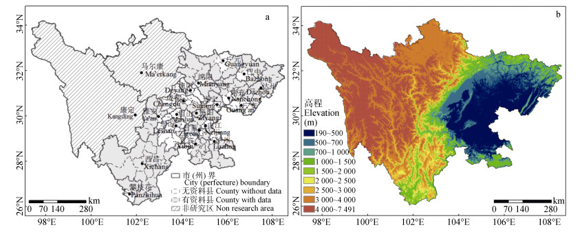
图1研究区域分布(a)及四川省各地高程(b)
Figure1.Overview of the study area (a) and elevation of all region of Sichuan Provinces (b)
 下载: 全尺寸图片幻灯片
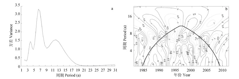
图2四川省1981—2012年水稻气象产量小波变换方差(a)和小波变换(b) (图b中粗实线为影响锥曲线, 线上部为受边界影响区域)
Figure2.Variance (a) and wavelet transform (b) of the meteorological yield of rice in Sichuan Province from 1981 to 2012 (in the figure b, the thick and solid line is the affected cone curve, the part over the line is affected by the boundary)
下载: 全尺寸图片幻灯片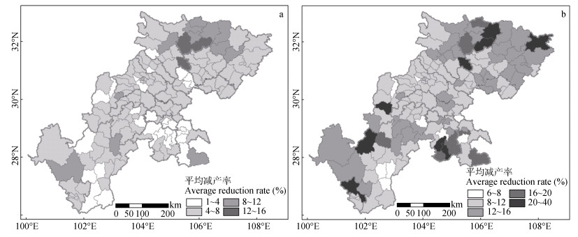
图3四川省1981—2012年歉收年(a)和成灾年(b)的水稻平均减产率分布
Figure3.Distribution of average yield reduction rates of rice in lean years (a) and disaster years (b) in Sichuan Province from 1981 to 2012
下载: 全尺寸图片幻灯片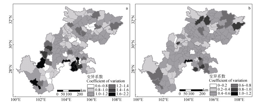
图4四川省1981—2012年歉收年(a)和成灾年(b)水稻减产率变异系数
Figure4.Variation coefficients of yield reduction rates of rice in lean years (a) and disaster years (b) in Sichuan Province from 1981 to 2012
下载: 全尺寸图片幻灯片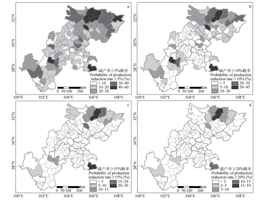
图5四川省水稻不同减产风险概率的空间分布
Figure5.Distribution of probabilities of different yield reduction rates of rice in Sichuan Province
下载: 全尺寸图片幻灯片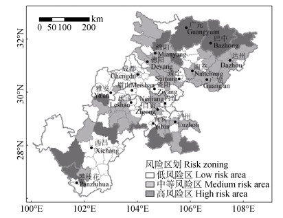
图6四川省水稻综合气象灾害风险区划
Figure6.Risk zoning of integrated meteorological disaster of rice in Sichuan Province
下载: 全尺寸图片幻灯片表1四川省水稻综合气象灾害风险分区减产特征
Table1.Characteristics of rice yield reduction of different zones of integrated meteorological disaster risk in Sichuan Province
| 风险区 Risk zone | 平均减产率 Average yield reduction rate (%) | 风险概率 Risk probability (%) | 分布县数 Number of counties | 分布地区 Distribution region | |||
| 歉收年 Lean years | 成灾年 Disaster years | 减产率≥5% Yield reduction rate≥5% | 减产率≥10% Yield reduction rate≥10% | ||||
| 低风险区Low-risk area | 4.4 | 10.1 | 14.2 | 2.8 | 75 | 成都、眉山、雅安北部、南充西部、乐山东北部、凉山州中东部等地区大部分县 Most counties in Chengdu, Meishan, North Ya’an, West Nanchong, Northeast Leshan, East-Central Liangshan, etc | |
| 中等风险区 Medium-risk area | 5.5 | 13.0 | 20.7 | 6.1 | 52 | 德阳、绵阳、遂宁、达州、广安、泸州、乐山南部等区域大部分县 Most counties in Deyang, Mianyang, Suining, Dazhou, Guang’an, Luzhou, South Leshan, etc | |
| 高风险区 High-risk area | 8.5 | 19.3 | 35.4 | 19.0 | 24 | 巴中各县、广元中东部各县、宜宾南部各县以及江油、盐亭、万源、荥经、古蔺、越西、美姑、盐源、盐边 Counties in Bazhong, East-Central Guangyuan and South Yibin, as well as counties with Jiangyou, Yanting, Wanyuan, Yingjing, Gulin, Yuexi, Meigu, Yanyuan, Yanbian | |
下载: 导出CSV参考文献
| [1] | 四川省气象局.四川省气候综合图集[M].北京:气象出版社, 2016:132-160 Sichuan Provincial Meteorological Service. Comprehensive Climatic Atlas of Sichuan Province[M]. Beijing:China Meteorological Press, 2016:132-160 |
| [2] | 赵珊珊, 高歌, 黄大鹏, 等. 2004-2013年中国气象灾害损失特征分析[J].气象与环境学报, 2017, 33(1):101-107 doi: 10.3969/j.issn.1673-503X.2017.01.014 ZHAO S S, GAO G, HUANG D P, et al. Characteristics of meteorological disaster losses in China from 2004 to 2013[J]. Journal of Meteorology and Environment, 2017, 33(1):101-107 doi: 10.3969/j.issn.1673-503X.2017.01.014 |
| [3] | HAN L Y, ZHANG Q, MA P L, et al. The spatial distribution characteristics of a comprehensive drought risk index in southwestern China and underlying causes[J]. Theoretical and Applied Climatology, 2016, 124(3/4):517-528 http://www.wanfangdata.com.cn/details/detail.do?_type=perio&id=ed8201009c614e7df86ab90fb618699a |
| [4] | 王春乙, 张继权, 霍治国, 等.农业气象灾害风险评估研究进展与展望[J].气象学报, 2015, 73(1):1-19 doi: 10.3969/j.issn.1005-0582.2015.01.001 WANG C Y, ZHANG J Q, HUO Z G, et al. Prospects and progresses in the research of risk assessment of agro-meteorological disasters[J]. Acta Meteorologica Sinica, 2015, 73(1):1-19 doi: 10.3969/j.issn.1005-0582.2015.01.001 |
| [5] | 王春乙, 姚蓬娟, 张继权, 等.长江中下游地区双季早稻冷害、热害综合风险评价[J].中国农业科学, 2016, 49(13):2469-2483 doi: 10.3864/j.issn.0578-1752.2016.13.003 WANG C Y, YAO P J, ZHANG J Q, et al. Risk assessment of cold and hot damages for double-cropping early rice (DCER) in lower-middle reaches of the Yangtze river basin[J]. Scientia Agricultura Sinica, 2016, 49(13):2469-2483 doi: 10.3864/j.issn.0578-1752.2016.13.003 |
| [6] | 杨建莹, 霍治国, 吴立, 等.西南地区水稻洪涝灾害风险评估与区划[J].中国农业气象, 2016, 37(5):564-577 doi: 10.3969/j.issn.1000-6362.2016.05.009 YANG J Y, HUO Z G, WU L, et al. Flood risk assessment and zoning for rice in Southwest China[J]. Chinese Journal of Agrometeorology, 2016, 37(5):564-577 doi: 10.3969/j.issn.1000-6362.2016.05.009 |
| [7] | 罗伯良, 黄晚华, 帅细强, 等.湖南省水稻生产干旱灾害风险区划[J].中国农业气象, 2011, 32(3):461-465 doi: 10.3969/j.issn.1000-6362.2011.03.023 LUO B L, HUANG W H, SHUAI X Q, et al. Risk division of drought disaster for rice production in Hunan Province[J]. Chinese Journal of Agrometeorology, 2011, 32(3):461-465 doi: 10.3969/j.issn.1000-6362.2011.03.023 |
| [8] | 陈超, 庞艳梅, 徐富贤, 等.四川水稻不同生育阶段的干旱风险评估[J].干旱地区农业研究, 2018, 36(6):184-193 http://d.old.wanfangdata.com.cn/Periodical/ghdqnyyj201806028 CHEN C, PANG Y M, XU F X, et al. Risk assessment of drought on rice at different growth stages in Sichuan Province[J]. Agricultural Research in the Arid Areas, 2018, 36(6):184-193 http://d.old.wanfangdata.com.cn/Periodical/ghdqnyyj201806028 |
| [9] | 陈超, 庞艳梅, 刘佳.四川省水稻高温热害风险及灾损评估[J].中国生态农业学报(中英文), 2019, 27(4):554-562 http://www.ecoagri.ac.cn/zgstny/ch/reader/view_abstract.aspx?file_no=2019-0406&flag=1 CHEN C, PANG Y M, LIU J. Assessment of risk and yield loss of rice in Sichuan Province due to heat stress[J]. Chinese Journal of Eco-Agriculture, 2019, 27(4):554-562 http://www.ecoagri.ac.cn/zgstny/ch/reader/view_abstract.aspx?file_no=2019-0406&flag=1 |
| [10] | 庞艳梅, 刘佳, 陈超.四川省单季稻高低温致灾因子危险性分析[J].西南大学学报:自然科学版, 2017, 39(8):9-16 http://d.old.wanfangdata.com.cn/Periodical/xnnydxxb201708002 PANG Y M, LIU J, CHEN C. Analysis of high and low temperature hazard risks for single cropping rice in Sichuan[J]. Journal of Southwest University:Natural Science Edition, 2017, 39(8):9-16 http://d.old.wanfangdata.com.cn/Periodical/xnnydxxb201708002 |
| [11] | 王婷, 袁淑杰, 王婧, 等.四川省水稻干旱灾害承灾体脆弱性研究[J].自然灾害学报, 2013, 22(5):221-226 http://www.wanfangdata.com.cn/details/detail.do?_type=perio&id=zrzhxb201305029 WANG T, YUAN S J, WANG J, et al. Study on vulnerability of drought hazard affected rice in Sichuan Province[J]. Journal of Natural Disasters, 2013, 22(5):221-226 http://www.wanfangdata.com.cn/details/detail.do?_type=perio&id=zrzhxb201305029 |
| [12] | 赵东妮, 王艳华, 任传友, 等. 3种水稻趋势产量拟合方法的比较分析[J].中国生态农业学报, 2017, 25(3):345-355 http://d.old.wanfangdata.com.cn/Periodical/stnyyj201703005 ZHAO D N, WNAG Y H, REN C Y, et al. Comparative analysis of three fitting methods of rice trend yield[J]. Chinese Journal of Eco-Agriculture, 2017, 25(3):345-355 http://d.old.wanfangdata.com.cn/Periodical/stnyyj201703005 |
| [13] | 王桂芝, 陆金帅, 陈克垚, 等.基于HP滤波的气候产量分离方法探讨[J].中国农业气象, 2014, 35(2):195-199 doi: 10.3969/j.issn.1000-6362.2014.02.012 WANG G Z, LU J S, CHEN K Y, et al. Exploration of method in separating climatic output based on HP filter[J]. Chinese Journal of Agrometeorology, 2014, 35(2):195-199 doi: 10.3969/j.issn.1000-6362.2014.02.012 |
| [14] | YE T, NIE J J, WANG J, et al. Performance of detrending models of crop yield risk assessment:Evaluation on real and hypothetical yield data[J]. Stochastic Environmental Research and Risk Assessment, 2015, 29(1):109-117 doi: 10.1007/s00477-014-0871-x |
| [15] | 邓国, 王昂生, 周玉淑.粮食生产风险水平的概率分布计算方法[J].南京气象学院学报, 2002, 25(4):481-488 doi: 10.3969/j.issn.1674-7097.2002.04.007 DENG G, WANG A S, ZHOU Y S. Grain yield risk level calculated by probability distribution[J]. Journal of Nanjing Institute of Meteorology, 2002, 25(4):481-488 doi: 10.3969/j.issn.1674-7097.2002.04.007 |
| [16] | 邵立瑛, 申双和, 高磊, 等.江苏省水稻生产的综合气象灾害风险评估[J].科学技术与工程, 2015, 15(32):232-239 doi: 10.3969/j.issn.1671-1815.2015.32.045 SHAO L Y, SHEN S H, GAO L, et al. Evaluating integrated meteorological disaster risk in rice production of Jiangsu Province[J]. Science Technology and Engineering, 2015, 15(32):232-239 doi: 10.3969/j.issn.1671-1815.2015.32.045 |
| [17] | 韩语轩, 房世波, 梁瀚月, 等.基于减产概率的辽宁水稻灾害风险区划[J].生态学报, 2017, 37(23):8077-8088 http://d.old.wanfangdata.com.cn/Periodical/stxb201723033 HAN Y X, FANG S B, LIANG H Y, et al. Disaster risk regionalization of rice based on its reduction probability in Liaoning Province[J]. Acta Ecologica Sinica, 2017, 37(23):8077-8088 http://d.old.wanfangdata.com.cn/Periodical/stxb201723033 |
| [18] | 钱永兰, 毛留喜, 周广胜.全球主要粮食作物产量变化及其气象灾害风险评估[J].农业工程学报, 2016, 32(1):226-235 http://d.old.wanfangdata.com.cn/Periodical/nygcxb201601032 QIAN Y L, MAO L X, ZHOU G S. Changes in global main crop yields and its meteorological risk assessment[J]. Transactions of the Chinese Society of Agricultural Engineering, 2016, 32(1):226-235 http://d.old.wanfangdata.com.cn/Periodical/nygcxb201601032 |
| [19] | 魏凤英.现代气候统计诊断与预测技术[M].第2版.北京:气象出版社, 2007:32-35 WEI F Y. Modern Diagnosis of Climate Statistics and Its Prediction[M]. 2nd ed. Beijing:China Meteorological Press, 2007:32-35 |
| [20] | 邓国卫, 孙俊, 郭海燕, 等.四川绵竹山洪灾害风险区划[J].高原山地气象研究, 2013, 33(2):69-73 doi: 10.3969/j.issn.1674-2184.2013.02.012 DENG G W, SUN J, GUO H Y, et al. Regional torrent risk zonation for Mianzhu City in Sichuan[J]. Plateau and Mountain Meteorology Research, 2013, 33(2):69-73 doi: 10.3969/j.issn.1674-2184.2013.02.012 |
| [21] | 罗玉, 陈超, 马振峰, 等. 1961-2015年四川省汛期极端降水指数时空变化研究[J].西南大学学报:自然科学版, 2018, 40(9):133-141 http://d.old.wanfangdata.com.cn/Periodical/xnnydxxb201809019 LUO Y, CHEN C, MA Z F, et al. Spatial-temporal variation of extreme precipitation indices during the main flood season in 1961-2015 in Sichuan[J]. Journal of Southwest University:Natural Science Edition, 2018, 40(9):133-141 http://d.old.wanfangdata.com.cn/Periodical/xnnydxxb201809019 |
| [22] | 曹艳秋, 罗佳, 邢开瑜, 等.四川凉山水稻花期冷害特征及其对产量的影响[J].贵州农业科学, 2017, 45(11):18-22 doi: 10.3969/j.issn.1001-3601.2017.11.006 CAO Y Q, LUO J, XING K Y, et al. Chilling injury of rice flowering and its impact on yield in Liangshan Prefecture of Sichuan Province[J]. Guizhou Agricultural Sciences, 2017, 45(11):18-22 doi: 10.3969/j.issn.1001-3601.2017.11.006 |
| [23] | 李军龙, 张剑, 张丛, 等.气象要素空间插值方法的比较分析[J].草业科学, 2006, 23(8):6-11 doi: 10.3969/j.issn.1001-0629.2006.08.002 LI J L, ZHANG J, ZHANG C, et al. Analyze and compare the spatial interpolation methods for climate factor[J]. Pratacultural Science, 2006, 23(8):6-11 doi: 10.3969/j.issn.1001-0629.2006.08.002 |
