Characteristics of evapotranspiration in planted shrub communities in desert steppe zone based on sap flow and lysimeter methods
Long-Long MA, Ling-Tong DU,*, Yang DAN, Le WANG, Cheng-Long QIAO, Hong-Yue WUBreeding Base for State Key Laboratory of Land Degradation and Ecological Restoration in Northwest China, Ningxia University, Yinchuan 750021, China; and Key Laboratory for Restoration and Reconstruction of Degraded Ecosystem in Northwest China of Ministry of Education, Ningxia University, Yinchuan 750021, China
National Natural Science Foundation of China(41967027) National Natural Science Foundation of China(41661003) Ningxia Excellent Talents Support Program(RQ0012) ��Light of West China�� Program of Chinese Academy of Sciences(XAB2017AW01) Project of First-Class Discipline Construction (Ecology) for Ningxia Higher Education(NXYLXK2017B06)
ժҪ �й���������ͨ��������ֲ�м������(Caragana liouana)������̬����, �ڻ�Į��ԭ�����γ��˹���Ծ���, �ı�����̬ϵͳ�Ľṹ����, Ӱ�쵽��-��ˮ��ѭ������, �о����˹����Ⱥ�����ɢ����, �Խ�ʾ����̬ˮ��ЧӦ��ָ���ط���̬����ʵ��������Ҫ���塣�����������γػ�Į��ԭ���ϵ��˹����Ⱥ��Ϊ��, ���þ���-�����Ƿ��ⶨ��2018��5-8�µĹ�ľ���ںʹ�����ɢ, �������˻������Ӷ��˹����Ⱥ����ɢ��Ӱ�졣�������: (1)����-�����Ƿ������Ⱥ����ɢ��ˮ��ƽ�ⷨ���ж���ط��õ���Ⱥ����ɢ�нϺõ�һ����, ����-�����Ƿ��������ڻ�Į��ԭ���˹����Ⱥ����ɢ������ֽṹ�IJⶨ; (2)�۲���������Ĺ�ľ�������ʺʹ�����ɢ�����ձ仯�������, ��Ϊ��������, Ⱥ����ɢ��Ҫ�������ռ�, ���������������ʵij���ʱ��ȴ�����ɢ������ʵij���ʱ����1 h; (3) 5-8�¼��ľ�ۻ�����Ϊ83.6 mm, ��ƽ��������Ϊ0.7 mm��d-1, ���ڱ仯��������״; ͬ�ڴ����ۻ���ɢΪ182.5 mm, ��ƽ����ɢ��Ϊ1.5 mm��d-1; ������ɢ���Դ��ڹ�ľ����; (4)�۲��ڼ��˹����Ⱥ���ۻ���ɢ266.1 mm, ��ͬ�ڵĽ�ˮ��Ϊ222.6 mm, ½��ˮ����֧���ڿ�ȱ״̬; (5)��������Ӱ����ɢ����Ҫ����ֱ�ӵ���������, ���ܹ�Ӱ���������ӽ������˹����Ⱥ����ɢ�������á�����, �˹����������Į��ԭ�ش�½��ˮ����֧��ȱ������, ����̬�ָ����ؽ���������ע�⡣ �ؼ��ʣ���Į��ԭ��;�˹����;����;ˮѭ��;�м������
Abstract AimsCaragana liouana has been widely planted in northwest China for ecological restoration which has induced the planted shrub landscape in the desert steppe zone and changed the structure and function of the original ecosystem. These plantations would affect the water vapor interactions between land surface and atmosphere eventually. Therefore, studying the evapotranspiration characteristics of the planted shrub communities in the desert steppe zone is significant for us to understand its ecohydrological mechanism and guide local ecological restoration. Methods The transpiration of shrubs and the evapotranspiration under shrub canopy in the desert steppe zone in Yanchi County, Ningxia, were measured by a coupled method of sap flow sensors and lysimeter from May to August in 2018. The effects of environmental factors on the evapotranspiration of the planted shrub communities were analyzed by path analysis. Important findings (1) The evapotranspiration obtained by the coupled method of sap flow sensors and lysimeter was consistent with the estimations based on the water balance method and the eddy covariance method. Thus, the coupled method of sap flow and lysimeter can be used to measure the evapotranspiration and its components of the planted shrub communities in the desert steppe zone. (2) The diurnal variations of transpiration rate of shrubs and the evapotranspiration rate under shrub canopy were consistent with each other, and both presented an obvious single peak at noon. The evapotranspiration of the planted shrub communities mainly occurred in day time. However, the time of the maximum transpiration rate of shrubs was 1 h later than that of the maximum evapotranspiration rate under shrub canopy. (3) The cumulative transpiration of shrubs was 83.6 mm, the daily average transpiration was 0.7 mm��d-1, and the series curve of daily transpiration had a parabolic shape from May to August. The cumulative evapotranspiration under shrub canopy was 182.5 mm, and the daily average evapotranspiration was 1.5 mm��d-1 during the same period. The evapotranspiration under shrub canopy was higher than the transpiration of shrubs. It can be concluded that the water consumption in the planted shrub communities is mainly caused by evapotranspiration under shrub canopy. (4) The total evapotranspiration of the planted shrub communities from May to August was 266.1 mm, and the total precipitation in the same period was 222.6 mm. Therefore, the water balance in the planted shrub communities was in deficit. (5) Net radiation is the most important and direct driving factor that affected evapotranspiration of the planted shrub communities, and it coupled other environmental factors to drive the process of evapotranspiration. Therefore, the water deficit in the planted shrub communities encroaching desert steppe zone should be paid attention in ecological restoration and reconstruction. Keywords��desert steppe zone;planted shrubs community;transpiration;water cycle;Caragana liouana
PDF (1510KB)Ԫ������ά�����������������EndNote|Ris|Bibtex�ղر��� ���ñ��� ������, ����ͨ, ����, ����, �dz���, ���h. ���ھ���-�����Ƿ��Ļ�Į��ԭ���˹����Ⱥ����ɢ����. ֲ����̬ѧ��, 2020, 44(8): 807-818. DOI: 10.17521/cjpe.2020.0104 MA Long-Long, DU Ling-Tong, DAN Yang, WANG Le, QIAO Cheng-Long, WU Hong-Yue. Characteristics of evapotranspiration in planted shrub communities in desert steppe zone based on sap flow and lysimeter methods. Chinese Journal of Plant Ecology, 2020, 44(8): 807-818. DOI: 10.17521/cjpe.2020.0104
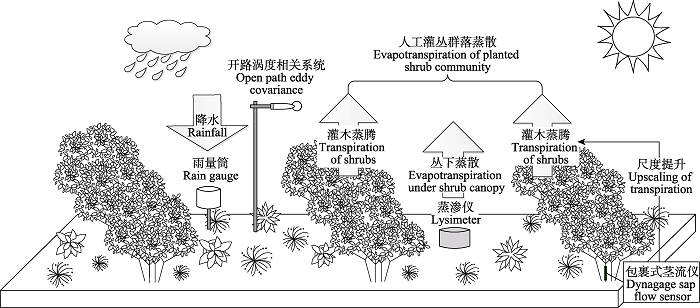
��ɢ(ET)����ֲ��ҶƬ����(T)������������ˮ���ֲ����������(E), ������-ֲ��-������ˮ����֧��������������Ҫ;��(Katul et al., 2012; Wang & Dickinson, 2012), Ҳ����ϵֲ��������Ϊ��ˮ�����ú�̼�����ȹؼ���̬���̵�Ŧ��(Mu et al., 2007), ��ά����̬ϵͳ���ȶ��Ծ�����Ҫ���塣ÿ��ȫ��½����̬ϵͳ��59%�Ľ�ˮͨ����ɢ���ش���, ���вݵ���̬ϵͳ�ﵽ��67.7% (Oki & Kanae, 2006), �ڸɺ�������(���ٵ�, 2012), �ɼ���ɢ�Ըɺ����ݵ�ˮ��ѭ������Ҫ���á������йء�������̡��Ļ�������㷺��ע, ����һ����Ҫ�������й���ֲ������(Chen et al., 2019), ����������Į��ԭ������̬����, ����һ�����̼ˮѭ���������������о�(Piao et al., 2020)�������γ�����20����ĩʵʩ��ϵ����̬��������, ������ֲ�м������(Caragana liouana)��ɳ��ɳ������̬, ���ڻ�Į��ԭ���γ���Լ8.9 �� 104 hm2���˹���Ծ���(֣����, 2019), �ı����������÷�ʽ��ֲ�����ͽṹ(����ƽ��, 2015)�������о�����, ֲ���Ƕ����ӻ���ǿ��̬ϵͳ��ɢ(Zhang et al., 2015); ͬʱ, �˹�����γɹ����еIJݱ����ľֲ������ת��, ��ı���̬ϵͳ������/���ڱ���(Schlesinger & Jasechko, 2014), Ҳ�ᵼ������ˮ�����ļ��ٺͿռ������ԼӾ�(�����ٵ�, 2014; ����骵�, 2018); ���˹���Ե��ȶ��Ժͳ������Բ�ȷ��(����, 2018)�����, �о��˹�ֲ���ؽ������»�Į��ԭ���˹����Ⱥ����ɢ����, ̽����ˮ�ֹ����ϵ����ˮ����, ��ָ��������̬�ɳ�������������Ҫ���塣
����-�����Ƿ����2018��5-8���˹����Ⱥ�����ɢ����Ϊ266.1 mm, ��ˮ��ƽ�ⷨ��õ�Ⱥ����ɢ����Ϊ298.2 mm, ����-�����Ƿ���õ���ɢ����ˮ��ƽ�ⷨ��õ���ɢ����, ���ߵľ������Ϊ32.1 mm, ������Ϊ10.8% (��2), ������˵, ����-�����Ƿ���ˮ��ƽ�ⷨ���������нϺõ�һ����, ˵������-�����Ƿ��ܹ������ڻ�Į��ԭ���˹����Ⱥ����ɢ�����IJⶨ��
Table 2 ��2 ��2����-�����Ƿ���ˮ��ƽ�ⷨ�ⶨ���˹����Ⱥ��5-8����ɢ�����Ա� Table 2Comparison of total evapotranspiration of a planted shrub communities measured by sap flow-lysimeter method and by water balance method from May to August
����-������ Sap flow-lysimeter method (mm)
ˮ��ƽ�ⷨ Water balance method (mm)
������� Absolute error (mm)
������ Relative error (%)
������ɢ ET under shrub canopy
��ľ���� Transpiration of shrub
Ⱥ����ɢ Total ET of community
��ˮ Precipitation
������ˮ���仯 ?W
Ⱥ����ɢ Total ET of community
182.5
83.6
266.1
222.6
75.6
298.2
32.1
10.8
ET, evapotranspiration; ?W, change of soil water content.
BaoZW, DuHL, ShiXB, MaWY (2013). A comparison between the rhizospheric irrigation and the drip irrigation by monitoring the soil evaporation with micro-lysimeters Journal of Desert Research, 33, 160-166. DOI:10.7522/j.issn.1000-694X.2013.00023URL [��������: 1] An investigation was carried out to compare the water-saving effects between the rhizospheric irrigation and drip irrigation in an ecological economic forest of red jujube in Xinjiang, China. The soil evaporation was monitored with micro-lysimeters made of PVC. The results showed that: (1) A micro-lysimeter with diameter of 12 cm and height of 15 cm could be used to well monitor the soil evaporation in the studied sites. (2) The soil water loss by evaporation in rhizospheric irrigation was about 50% of that in drip irrigation, and about 11% less than that in the tape-drip irrigation [ ������, �Ż���, ʷѧ��, ������ (2013). ���������Dz�������ˮDZ������������о� �й�ɳĮ, 33, 160-166.] [��������: 1]
BianYY, SongNP, WangX, XiaoXP (2015). Soil water deficit under different land-use type in desert steppe Journal of Soil and Water Conservation, 29, 201-206. [��������: 1]
CaiJB, XuD, LiuY, ZhangBZ (2011). Path analysis on spatio-temporal scaling effect of crop evapotranspiration in growing seasons for winter wheat after reviving Transactions of the Chinese Society of Agricultural Engineering, 27(8), 69-76. URL [��������: 1] The spatio-temporal scaling effect of crop evapotranspiration (ET) is a scientific basis for efficient water using and water saving management. In this paper, the path analyses method was used to investigate the main impact factors and spatio-temporal effects of ET at different scale for winter wheat after reviving. The actual evapotranspiration (ETa) in plot was measured by weighing lysimeter and the areal latent water flux (LE) was monitored from the eddy covariance system in the agricultural field. The results showed that the scaling effects were significant for ET in space and time scale, and main impact factors were diverse for ETa and LE in whole day (24 hours) and daylight (7:00-18:00). For ETa in plot, main impact factors were the crop leaf area index (LAI) and net radiation (Rn) in whole day, the saturation vapour pressure deficit (VPD_7-18) and the LAI in daylight (7:00-18:00). Otherwise, for LE in area, Rn and crop height (H) were the main impact factors in whole day, the VPD_7-18 and H in daylight, respectively. In conclusion, the temporal scaling effect on ET was that the main impact factor was Rn for whole day and VPD for daylight. The spatial scaling effect on ET was that the ET in plot was sensitive to the crop LAI and the areal LE was related to the undersurface crop height. [ �̼ױ�, ����, ����, �ű��� (2011). ��С������ڷ���ʱ�ճ߶�ЧӦ��ͨ������ ũҵ����ѧ��, 27(8), 69-76.] [��������: 1]
ChaiYF, XuJS, LiuHY, LiuQR, ZhengCY, KangMY, LiangCZ, WangRQ, GaoXM, ZhangF, ShiFC, LiuX, YueM (2019). Species composition and phylogenetic structure of major shrublands in North China Chinese Journal of Plant Ecology, 43, 793-805. DOI:10.17521/cjpe.2018.0173URL [��������: 1] Aims Shrublands are widely distributed in the North China. Understanding species composition and community assembly of the shrublands has important implications for promoting vegetation restoration in this area. Community phylogenetic structure can reflect community assembly process. In the present study, we explored the distribution patterns, species composition and phylogenetic structure of major shrubland types from North China, and then analyzed the effects of temperature and precipitation on these patterns with the help of the WorldClim dataset.Methods A total 2 331 plots were setup to survey species composition and phylogenetic structure of major shrubland types in North China. A multiple stepwise regression was used to determine the effects of climatic factors on community phylogenetic structure, and a generalize linear model was used to test the interaction of environmental factors and formation types or vegetation types.Important findings A total of 570 woody species belonging to 207 genera from 75 families, together with 1 221 herb species belonging to 491 genera from 99 families were recorded during the investigation. Five vegetation types and 195 formation types were identified, and the major formation types were Ostryopsis davidiana formation, Vitex negundo var. heterophylla, Vitex negundo var. heterophylla + Hippophae rhamnoides and Hippophae rhamnoides formation. The species richness of herb layer was higher than that of shrub layer. The phylogenetic structure was over-dispersed for herb layer and was convergent for shrub layer. The phylogenetic structure differed remarkable among different vegetation types. The phylogenetic structures of both shrub and herb layers were significantly correlated with climatic factors, and the interaction of climate factors and vegetation types or formation types as well. Our results indicates that large scale variation of climatic factors regulate community phylogenetic structure of different layers in shrub community, and the effects depend on vegetation types and formation types.]]> [ ������, ����ʯ, ������, ��ȫ��, ֣����, ��Ľ��, ������, ������, ������, �ŷ�, ʯ����, ����, ���� (2019). ����������Ҫ���Ⱥ��������ɼ�ϵͳ�����ṹ���� ֲ����̬ѧ��, 43, 793-805.] [��������: 1]
ChenC, ParkT, WangXH, PiaoSL, XuBD, ChaturvediRK, FuchsR, BrovkinV, CiaisP, FensholtR, T?mmervikH, BalaG, ZhuZC, NemaniRR, MyneniRB (2019). China and India lead in greening of the world through land-use management Nature Sustainability, 2, 122-129. DOI:10.1038/s41893-019-0220-7URLPMID:30778399 [��������: 1] Satellite data show increasing leaf area of vegetation due to direct (human land-use management) and indirect factors (climate change, CO2 fertilization, nitrogen deposition, recovery from natural disturbances, etc.). Among these, climate change and CO2 fertilization effect seem to be the dominant drivers. However, recent satellite data (2000-2017) reveal a greening pattern that is strikingly prominent in China and India, and overlapping with croplands world-wide. China alone accounts for 25% of the global net increase in leaf area with only 6.6% of global vegetated area. The greening in China is from forests (42%) and croplands (32%), but in India is mostly from croplands (82%) with minor contribution from forests (4.4%). China is engineering ambitious programs to conserve and expand forests with the goal of mitigating land degradation, air pollution and climate change. Food production in China and India has increased by over 35% since 2000 mostly due to increasing harvested area through multiple cropping facilitated by fertilizer use and surface/ground-water irrigation. Our results indicate that the direct factor is a key driver of the
DuanLM, TongX, L��Y, YanX, LiuTX, WangXX (2018). Upscaling of the transpiration and water consumption of sand-fixing vegetation Salix gordejevii and Caragana microphylla Journal of Natural Resources, 33, 52-62. [��������: 2]
FangK, SongNP, AnH, WeiL (2011). Quantitative classification and ordination of plant communities in a desert steppe in Yanchi County of Ningxia, Northwest China Chinese Journal of Ecology, 30, 2719-2725. URL [��������: 1] i.e., Stipa bungeana, Pennisetum centrasiaticum, and Leymus secalinus, which were characterized by arid, mesophytic, and light salinization habitats, respectively, according to the biological characteristics of the constructive or dominant species. These three plant formations belonged to different succession stages, with the S. bungeana formation as a reaction stage and the L. secalinus formation as a higher stage. There was a strong competition on resources between these formations, and wind erosion could expand L. secalinus formation. Therefore, the rational regulation of grazing time in S. bungeana formation and L. secalinus formation by rotation grazing could improve the use efficiency of the grassland, and decrease the expansion risk of L. secalinus formation.]]> [ ����, ����ƽ, ����, κ�� (2011). �����γػ�Į��ԭֲ����������������� ��̬ѧ��־, 30, 2719-2725.] [��������: 1]
GaoH, QinSG, ZhuLF, FanDQ, ChenD, YangLM (2016). Characteristics of water consumption of Artemisia ordosica through transpiration and its relationships with environmental factors Bulletin of Soil and Water Conservation, 36(2), 76-81. [��������: 1]
GaoQ, LiuT (2015). Causes and consequences of shrub encroachment in arid and semiarid region: a disputable issue Arid Land Geography, 38, 1202-1212. URL [��������: 1] Shrub encroachment of grassland is defined as the increase in density,cover and biomass of indigenous woody or shrubby plants in grasslands,and the phenomenon has been documented for many arid and semiarid regions in the world. The causes of woody plant encroachment are complex,among which livestock overgrazing has been considered as a major one in early studies. Recent studies indicate that the direct factor to trigger shrub encroachment is not overgrazing,but the shift of grazing intensity after long-term overgrazing because the shift changes the interaction between grass and shrub. Shrub may get established in open areas during long-term overgrazing before productive herbaceous species evolve back. Many other factors,such as changes in rainfall seasonality and intensity,altered fire regimes,as well as elevated carbon dioxide level in atmosphere,may also mediate shrub encroachment of grassland. The replacement of herbaceous plants in grassland by shrubs had been shown to decrease the grassland productivity,to increase soil erosion,and to reduce the soil carbon storage. Therefore,shrub encroachment of grassland has long been considered as a process of grassland degradation. However, recent global synthetic analyses indicate that the impact of increased shrub cover in grassland may not always be negative. In many cases,it increased upward and downward water movement as well as soil nitrogen mineralization,hence enhanced the storage of water and nutrients in ecosystem. Given the above advances and discrepant conclusions and explanation,we suggest more studies should follow to test the generality of the above conclusions. On the other hand,grassland managers should also be alerted,as appropriate plans of conservation and production may just opposite to our intuitive understanding. [ ����, ���� (2015). �ɺ���ɺ�����ԭ��Ի���ԭ��Ӱ�졪���������չ �ɺ�������, 38, 1202-1212.] [��������: 1]
HuangL, ZhangZ, LiX (2015). The extrapolation of the leaf area-based transpiration of two xerophytic shrubs in a revegetated desert area in the Tengger Desert, China Hydrology Research, 46, 389-399. DOI:10.2166/nh.2014.171URL [��������: 1]
JiX, ZhaoW, KangE, JinB, XuS (2016). Transpiration from three dominant shrub species in a desert-oasis ecotone of arid regions of Northwestern China Hydrological Processes, 30, 4841-4854. DOI:10.1002/hyp.v30.25URL [��������: 1]
KatulGG, OrenR, ManzoniS, HigginsC, ParlangeMB (2012). Evapotranspiration: a process driving mass transport and energy exchange in the soil-plant-atmosphere- climate system Reviews of Geophysics, 50, RG3002. DOI: 10.1029/2011rg000366. [��������: 1]
KumagaiT, NagasawaH, MabuchiT, OhsakiS, KubotaK, KogiK, UtsumiY, KogaS, OtsukiK (2005). Sources of error in estimating stand transpiration using allometric relationships between stem diameter and sapwood area for Cryptomeria japonica and Chamaecyparis obtusa Forest Ecology and Management, 206, 191-195. DOI:10.1016/j.foreco.2004.10.066URL [��������: 1]
LiFM, ZhangZW (1991). The study on water use of the alfalfa grassland and the Stipa bungeana grassland in Ningxia Yanchi Acta Phytoecologica et Geobotanica Sinica, 15, 319-329. [��������: 1]
LiQ, ChenX, LiuY, BaoAM, VeroustraeteF (2012). Regional evapotranspiration retrieval in arid areas Journal of Arid Land Resources and Environment, 26(8), 108-112. [��������: 1]
LiXR, ZhangZS, TanHJ, GaoYH, LiuLC, WangXP (2014). Ecological restoration and recovery in the wind-blown sand hazard areas of northern China: relationship between soil water and carrying capacity for vegetation in the Tengger Desert Science in China (Life Science), 44, 257-266. [��������: 1]
LiuCF, ZhangZQ, SunG, ZhaTG, ZhuJZ, ShenLH, ChenJ, FangXR, ChenJQ (2009). Quantifying evapotranspiration and biophysical regulations of a poplar plantation assessed by eddy covariance and sap-flow methods Chinese Journal of Plant Ecology, 33, 706-718. DOI:10.3773/j.issn.1005-264x.2009.04.009URL [��������: 2] Aims Using field data from an eddy-covariance (EC) flux tower and sap-flow sensors installed in a poplar (Populus euramericana) plantation, we investigated the magnitudes and changes of evapotranspiration (ET) under different soil moisture and climatic conditions. Our objectives were to quantify the energy partitioning and energy balance, explore the dynamic process and regulatory mechanisms on ET, and understand primary biophysical regulations, especially soil moisture. Methods An open path EC system, sap-flow sensors, soil water balance monitoring system, and microclimatic station were installed to record various components of energy fluxes and water budget at an 11-year-old poplar plantation in Daxing District, Beijing, China. We used data collected at 30-min intervals in the growing season of 2006 in this study. Important findings The overall energy closure of the study site was high (86%) during the growing season, but with notable dependence on soil water conditions. The ratio between sensible heat and net radiation (Hs:Rn) was much higher during dry conditions than that during moist conditions. With dry soils, net radiation and soil physical properties played important roles in transpiration, which was less than evaporation prior to rain events. In contrast, transpiration exceeded evaporation when the soil water content in the deep layers was more abundant following rain events. The total ET rates quantified by the soil water balance and sap-flow methods were comparable and lower than that determined by the EC method. The ratio between transpiration and ET appeared to be more dependent on net radiation and vapor pressure deficit (VPD) during wet periods than that during dry periods. ]]> [ ������, ��־ǿ, ���, ��ͬ��, �����, ���, �¾�, ������, �¼�Ȫ (2009). �����ж���ط�������Һ�������������˹�����̬ϵͳ����ɢ���价����Ӧ ֲ����̬ѧ��, 33, 706-718.] [��������: 2]
LiuK (2018). Multi Time Scale Characteristics of Evapotranspiration of Arctificial Caragana korshinskii Forests in Desert Steppe. Master degree dissertation, Ningxia University, Yingchuan. [��������: 1]
MacNish RD, UnkrichCL, SmytheE, GoodrichDC, MaddockIII T (2000). Comparison of riparian evapotranspiration estimates based on a water balance approach and sap flow measurements Agricultural and Forest Meteorology, 105, 271-279. DOI:10.1016/S0168-1923(00)00196-9URL [��������: 1]
MoBR, CaiGJ, YangL, LuJ, WangZT, DangHZ, WangDF, QiJL (2013). Soil water use and balance characteristics in mature forest land profile of Caragana korshinskii in semiarid loess area Acta Ecologica Sinica, 33, 4011-4020. DOI:10.5846/stxbURL [��������: 1]
MuQZ, HeinschFA, ZhaoMS, RunningSW (2007). Development of a global evapotranspiration algorithm based on MODIS and global meteorology data Remote Sensing of Environment, 111, 519-536. DOI:10.1016/j.rse.2007.04.015URL [��������: 1]
OkiT, KanaeS (2006). Global hydrological cycles and world water resources Science, 313, 1068-1072. DOI:10.1126/science.1128845URLPMID:16931749 [��������: 1] Water is a naturally circulating resource that is constantly recharged. Therefore, even though the stocks of water in natural and artificial reservoirs are helpful to increase the available water resources for human society, the flow of water should be the main focus in water resources assessments. The climate system puts an upper limit on the circulation rate of available renewable freshwater resources (RFWR). Although current global withdrawals are well below the upper limit, more than two billion people live in highly water-stressed areas because of the uneven distribution of RFWR in time and space. Climate change is expected to accelerate water cycles and thereby increase the available RFWR. This would slow down the increase of people living under water stress; however, changes in seasonal patterns and increasing probability of extreme events may offset this effect. Reducing current vulnerability will be the first step to prepare for such anticipated changes.
PiaoSL, WangXH, ParkT, ChenC, LianX, HeY, BjerkeJW, ChenAP, CiaisP, T?mmervikH, NemaniRR, MyneniRB (2020). Characteristics, drivers and feedbacks of global greening Nature Reviews Earth & Environment, 1, 14-27. [��������: 1]
QiXJ, LiuTX, DuanLM, ChenXP, HuangTY (2019). Transpiration and evapotranspiration of Caragana Microphylla community measured with the sap flow and eddy covariance methods Journal of Desert Research, 39(4), 73-82. [��������: 1]
QuYP, KangSZ, WangSF, SunHQ (2014). Applicability analysis for measuring evapotranspiration of Populus alba var. Pyramidalis Bge by sap flow and micro-lysimeter method Agricultural Research in the Arid Areas, 32(3), 88-94. [��������: 3]
SchlesingerWH, JasechkoS (2014). Transpiration in the global water cycle Agricultural and Forest Meteorology, 189- 190, 115-117. [��������: 1]
SeneviratneSI, CortiT, DavinEL, HirschiM, JaegerEB, LehnerI, OrlowskyB, TeulingAJ (2010). Investigating soil moisture-climate interactions in a changing climate: a review Earth Science Reviews, 99, 125-161. DOI:10.1016/j.earscirev.2010.02.004URL [��������: 1]
SongLL, YinYH, WuSH (2012). Advancements of the metrics of evapotranspiration Progress in Geography, 31, 1186-1195. DOI:10.11820/dlkxjz.2012.09.010URL [��������: 1] Evapotranspiration (ET) is very important for water cycle, and is determinant for the estimation of water and heat transfer in the Soil-Plant-Atmosphere Continuum (SPAC). Quantitative estimation of ET is the base of appraising terrestrial NPP, water conservation valuation, regional water consumption, soil water transport and crop production. It is important for studies on global climate change. More and more ET models and associated measurements are being reported in the literature and used to develop, calibrate and test important ET process models. The ET data can be derived from a range of measurement systems including lysimeters, eddy covariance, Bowen ratio and sap flow. In addition, the satellite-based remote sensing and direct models (e.g. radiation- based models and combination models) can also been important methods to evaluate the ET. This paper distinguished the methods of ET evaluation into ET measuring and ET modeling, with outline of different types of ET models and ET measurements involving principles, merits and disadvantages. Key issues and development direction in ET were evaluated to provide a guide to evaluate accurately ET for other researches. [ ����, ���ƺ�, ���ܺ� (2012). ��ɢ���ⶨ�����о���չ ������ѧ��չ, 31, 1186-1195.] [��������: 1]
SongNP, DuLT, WangL (2015). Vegetation dynamics over 2000-2012 and its driving factors in Yanchi County, Ningxia Province Acta Ecologica Sinica, 35, 7377-7386. [��������: 1]
SoubieR, HeineschB, GranierA, AubinetM, VinckeC (2016). Evapotranspiration assessment of a mixed temperate forest by four methods: eddy covariance, soil water budget, analytical and model Agricultural and Forest Meteorology, 228-229-191-204. [��������: 1]
WangKC, DickinsonRE (2012). A review of global terrestrial evapotranspiration: observation, modeling, climatology, and climatic variability Reviews of Geophysics, 50, RG2005. DOI: 10.1029/2011RG000373. [��������: 1]
WangL, XuYD, FuBJ, L��YH (2009). Landscape pattern and eco-hydrological process Advances in Earth Science, 24, 1238-1246. URL [��������: 1] There is tight connection and interaction between landscape patterns and eco-hydrological processes, especially in the arid and semi��arid regions. The complex interaction between them is one of the research frontiers. Scale, as an important impact factor on both of landscape patterns and eco��hydrological processes, plays an important role in their relationship. Interaction mechanisms may be distinct in different scales. In this article, we reviewed the domestic and foreign research of landscape patterns and eco-hydrological processes in the semi-arid regions in different scales, including the patch scale, the slope scale and the watershed scale. We also discussed the interaction mechanisms, the main influential factors, the effects of disturbance, especially the human beings′ disturbance, and the main models. Finally��the problems, insufficiencies and tendency of the present studies are put forward, including further study in physical mechanism, recovery mechanism after disturbance and simulation models. At the same time, we should pay more attention to the interactions in the watershed scale and the scale conversion.�� [ ����, ���Ӵ�, ������, ��һ�� (2009). ��ɺ������۸������̬ˮ�Ĺ����о���չ �����ѧ��չ, 24, 1238-1246.] [��������: 1]
WangWN, ZhangX, ZhangLF, LiuXQ, ZhaoL, LiQ, GuS (2019). A comparison study of the evapotranspiration measured by lysimeter and eddy covariance Chinese Journal of Ecology, 38, 3551-3559. [��������: 1]
XuJJ, JinXY, QiangHF, DaiH, LiangC (2018). Variety characteristics and cause analysis of potential evapotranspiration in the Ebinur Lake Basin in Xingjiang Journal of Irrigation and Drainage, 37(2), 89-94. [��������: 1]
YangXG, ZhaoW, ChenL, WangL, SongNP (2015). Antidromal succession between soil and plant in the Caragana intermedia shrubland in the desert steppe Ecology and Environmental Sciences, 24, 590-594. [��������: 1]
YueGY, ZhangTH, ZhaoHL, NiuL, LiuXP, HuangG (2006). Characteristics of sap flow and transpiration of Salix gordejevii and Caragana microphylla in Horqin Sandy Land, northeast China Acta Ecologica Sinica, 26, 3205-3213. [��������: 1]
YueGY, ZhaoHL, ZhangTH, YunJY, NiuL, HeYH (2007). Characteristics of Caragana microphylla sap flow and water consumption under different weather conditions on Horqin sandy land of northeast China Chinese Journal of Applied Ecology, 18, 2173-2178. URLPMID:18163294 [��������: 1] Employing heat balance Dynamax packaged sap flow measuring system and automatic weather recording system, the sap flow of artificial Caragana microphylla community on Horqin sandy land of northeast China was monitored consecutively in 2006, and the photosynthetically effective radiation, air temperature, relative humidity and wind velocity were measured synchronously. According to the manual records of weather conditions, four most representative weather conditions were gathered up to analyze the relationships of C. microphylla sap flow and its single branch water consumption with test meteorological factors. The results showed that under high air temperature and intense radiation on sunny days, the diurnal variation of C. microphylla sap flow appeared a broad peak curve, so as to adapt the circumstance of drought and water shortage via lower transpiration. The diurnal variations of sap flow and its dominant affecting factors differed with weather conditions, and photosynthetically effective radiation was always the dominant factor affecting the sap flow. The variation of the sap flow was the result of comprehensive effects of multi-meteorological factors, and the overall variation trend of water consumption of single branch was declined in the order of sunny days > cloudy days > windy days > rainy days, with the mean value being 459, 310, 281 and 193 mg x d(-1), respectively. [ ������, �Թ���, ��ͭ��, �ƽ�Ӣ, ţ��, ����� (2007). ��ͬ����������СҶ��������������ˮ���� Ӧ����̬ѧ��, 18, 2173-2178.] PMID:18163294 [��������: 1]
YueGY, ZhaoHL, ZhangTH, ZhaoXY, ZhaoW, NiuL, LiuXP (2009). Estimation of transpiration in communities dominated by shrub Caragana microphylla Chinese Journal of Plant Ecology, 33, 508-515. DOI:10.3773/j.issn.1005-264x.2009.03.010URL [��������: 1] Aims Our objectives were to develop an appropriate procedure for scaling up the sap flow from individual stems to the whole shrub and to the plot and to assess the utility of using sap flow gauges to determine the stand-level transpiration of shrub plantations in a semiarid sandy environment. Methods Sap flow rates of stems in a 15-year-old Caragana microphylla shrub in Horqin Sandy Land, China were measured using the stem heat balance techniques in June 2006 to determine transpiration of the C. microphylla plantation. The gauge-equipped stems, ranging in basal diameter from 0.4 to 1 cm, were selected on the basis of statistical analysis within the representative sampling plot for determining the ��mean stem��. Synchronously, total leaf area of the plant was measured by the basal cross-sectional area method and the leaf area density (LAD) method. We took advantage of the sparse distribution of C. microphylla and the ease of directly measuring LAD for individual shrubs to create a new scaling method based on these direct LAD measurements for shrubs in the study plot. We extrapolated the measurements of water use by individual stems to determine the area-averaged transpiration of the shrubland. The method used for the extrapolation assumed that the transpiration of a shrub was proportional to its leaf area. Important findings We found daily differences of <14.3% between transpiration estimated with sap measurements and with a weighing lysimeter reference, suggesting that the scaling procedure can be used to provide reliable estimates of transpiration from the shrub C. microphylla in Horqin Sandy Land. ]]> [ ������, �Թ���, ��ͭ��, ��ѧ��, ����, ţ��, ����ƽ (2009). СҶ���������Ⱥ�����ں�ˮ�����㷽�� ֲ����̬ѧ��, 33, 508-515.] [��������: 1]
ZhangK, KimballJS, NemaniRR, RunningSW, HongY, GourleyJJ, YuZ (2015). Vegetation greening and climate change promote multidecadal rises of global land evapotranspiration Scientific Reports, 5, 15956. DOI: 10.1038/srep15956. DOI:10.1038/srep15956URLPMID:26514110 [��������: 1]
ZhangPJ, QingH, ZhangL, XuYD, MuL, YeRH, QiuX, ChangH, ShenHH, YangJ (2017). Population structure and spatial pattern of Caragana tibetica communities in Nei Mongol shrub-encroached grassland Chinese Journal of Plant Ecology, 41, 165-174. DOI:10.17521/cjpe.2015.0448URL [��������: 1] Aims The community structure and function of the shrub-encroached grassland, as well as its formation mechanism, is one of hot scientific problems in vegetation science. The spatial pattern analysis is an important means for studying plant population interactions and the relationships between plant population and environment. The shrub-encroached grassland is one major vegetation type in Nei Mongol. Knowledge on the spatial pattern of shrub can improve our understanding on adaptive characteristics of shrub to steppe environment. Methods We chose Caragana tibetica encroached grassland distributed in Ordos City as research objects. The spatial position of each C. tibetica individual in 64 m × 64 m study plot was determined by a method of “three-distance location method”, and then the spatial pattern and intraspecific associations of C. tibetica individuals was analyzed with the point pattern analysis. Important findings The results showed that C. tibetica population was at the rising stage. The mature individuals showed a uniform distribution at the scale of less than 3.7 m, subsequently exhibiting a random distribution with an increased scale. The juvenile individuals showed an aggregation distribution at the scale of 0.3-20.4 m, but a uniform distribution at other scales. The dead C. tibetica individuals were distributed aggregately at the scale from 0.7 to 1.4 m, but randomly at other scales. An indistinctive positive association was found for live C. tibetica individuals to dead individuals at the scale of less than 9.9 m, but no associations was found between them at other scales. The mature individuals negatively interacted with juveniles at the scale of larger than 2.2 m, but unassociated at the other scales.]]> [ ��豽�, �廪, ����, ���Ӵ�, ľ��, ����, ����, ����, ��, ��� (2017). ���ɹŹ�Ի���ԭë�̽�������Ⱥ�ṹ�Ϳռ�ֲ���� ֲ����̬ѧ��, 41, 165-174.] [��������: 1]
ZhangQ, WangS, WenXM, NanYH, ZengJ (2012). An experimental study of land surface condense phenomenon and water budget characteristics over the Loess Plateau Acta Meteorologica Sinica, 70, 128-135. DOI:10.11676/qxxb2012.012URL [��������: 1] The Chinese Loess Plateau is a unique area in the world, dominated by a semi arid climate with unusual land surface hydrology. The previous studies have paid little attention to the non precipitation land surface hydrological processes, such as dew formation, on the semi arid Loess Plateau. Therefore, it is important to improve our understanding of the micrometeorological conditions controlling dew formation and the main characteristics of the land surface water balance. Here, we have analysed the observation data on land surface processes, collected at the Dingxi observational station in the LOPEX experimental area, to investigate the relationships between dewfall (or frost) amount and micrometeorological conditions, the characteristics of the seasonal distribution of dewfall (frost) and the influence of precipitation and other weather conditions on dewfall (frost). The fractional contributions of precipitation, dewfall, fog and soil adsorbed water to the land surface water balance are also calculated. The differences between land surface evapotranspiration rates observed by the three methods (eddy covariance, large lysimeter and evaporation pan), and the balance between evapotranspiration and the total land surface water sources are discussed. The land surface water sources, without precipitation or evapotranspiration, jointly constitute a diurnal cycle known as ��water respiration�� on the land surface. It has been found that the amount of dewfall (frost) is influenced by micrometeorological conditions: a higher relative humidity of the atmosphere surface layer leads to greater dewfall (frost). The amount of dew (frost) is greatest under an inversion strength of 0.25�� and wind speed of 1.5 m/s, explaining why dewfall totals are the greatest in autumn, second greatest in spring and the lowest in summer and winter. Over an annual cycle, the total land surface water sources are similar to evapotranspiration values observed by both the methods of lysimeter and eddy covariance, indicating that the land surface water budget is close to a steady state. In the semi arid region of the Loess Plateau, precipitation is still the dominant water source, but non precipitation surface water can account for more than about 15% of the total land surface water sources. Of these non precipitation land surface water sources, soil absorbed water is the greatest, followed by dew, and fog is the weakest. [ ��ǿ, ��ʤ, ����÷, �����, ���� (2012). ������ԭ½��ˮ�ֵ�����������֧���������о� ����ѧ��, 70, 128-135.] [��������: 1]
ZhangZS, LiXR, WangXP, ZhangJG, LiuLC, TanHJ (2005). Evaporation and transpiration in re-vegetated desert area Acta Ecologica Sinica, 25, 2484-2490. [��������: 2]
ZhaoW, YangMX, ChenL, WangL, SongNP, YangXG (2015). Structure and dynamics of herbaceous layer vegetation of artificial Caragana intermedia shrublands in desert steppe. Journal of Zhejiang University (Agriculture & Life Sciences), 41, 723-731. DOI:10.1016/0024-3205(87)90452-8URLPMID:3039270 [��������: 1] [3H]ET (etorphine), which is considered either as an [ ��ΰ, ������, ����, ����, ����ƽ, ���¹� (2015). ��Į��ԭ�˹������ֲݱ���ֲ���Ľṹ�붯̬ �㽭��ѧѧ��(ũҵ��������ѧ��), 41, 723-731.] PMID:3039270 [��������: 1]
ZhaoYN, YuL, ZhouYR, WangHM, MaQH, LuQ (2020). Soil moisture dynamics and deficit of desert grassland with anthropogenic introduced shrub encroachment in the eastern Ningxia, China Acta Ecologica Sinica, 40, 1305-1315. [��������: 1]
ZhaoYN, ZhouYR, WangHM (2018). Spatial heterogeneity of soil water content under introduced shrub (Caragana korshinskii) in desert grassland of the eastern Ningxia, China Chinese Journal of Applied Ecology, 29, 3577-3586. DOI:10.13287/j.1001-9332.201811.001URLPMID:30460804 [��������: 1] Combined with geographic information system (GIS) data, the spatial heterogeneity of soil water in the 0-200 cm soil layer of the desert steppe with the introduction of the shrub Caragana korshinskii in eastern Ningxia was studied by classical statistical and geostatistical methods. It was found that the soil water content of each soil layer in the 0-200 cm profile was relatively low, ranging from 0.6% to 19.0% (averaged 4.4%). The coefficient of soil water content variation ranged from 49.5% to 86.3%, which indicated moderate spatial heterogeneity. The variation of soil water content at the 0-60 cm and 80-120 cm soil layers fitted the spherical model, while that at the 60-80 cm soil layer fitted the exponential model and that at the 120-200 cm soil layer fitted the Gaussian model. Soil water content at different soil layers showed different degrees of spatial autocorrelation. The nugget/sill [C0/(C0+C)] of soil water content in the 0-40, 60-80, and 120-200 cm soil layers ranged from 26.1% to 49.9%, with moderate spatial correlations. The nugget/sill of soil water content in the 40-60 cm, 80-100 cm, and 100-120 cm soil layers ranged from 15.5% to 22.1%, with strong spatial correlations. The scale of spatial heterogeneity in soil water content (A0) varied among soil layers. The A0 was relatively large in the 0-20 and 20-40 cm soil layers (37.10-45.18 km) and small in the 40-200 cm soil layers (3.58-8.66 km). The results indicated that the introduction of C. korshinskii shrubs into desert grassland for vegetation recovery in recent decades have depleted soil water and accelerated the depletion of soil water in the deep layer (40-200 cm), leading to spatial heterogeneity and fragmentation of soil water (0-200 cm) with stronger effects at deep soil layer. [ �����, ������, ����÷ (2018). ���Ķ�����Į��ԭ�������������ˮ�ֿռ������� Ӧ����̬ѧ��, 29, 3577-3586.] PMID:30460804 [��������: 1]
ZhengQQ (2019). Landscape Distribution and Biomass Estimation of Caragana intermedia Plantation in Yanchi Desert Steppe based on Remote Sensing Technology. Master degree dissertation, Ningxia University, Yingchuan. [��������: 2]
ZhuL, QiYS, XuX (2014). Water sources of Medicago sativa grown in different slope positions in Yanchi County of Ningxia Chinese Journal of Plant Ecology, 38, 1226-1240. DOI:10.3724/SP.J.1258.2014.00118URL [��������: 2] Aims Alfalfa (Medicago sativa) is considered as an elite forage with high economic and ecological values. In semi-arid areas of Northwest China, the low rainfall is far from satisfying water demand of alfalfa. The northern part of Yanchi County is adjacent to Mu Us desert and has a shallow groundwater table. In this area, groundwater could be the potential water sources for growing alfalfa. Our objective was to investigate the growth performance and potential water sources of alfalfa grown in four slope positions with different altitudes in the bottomland of northern Yanchi County.Method Stable 18O and D isotope compositions (δ18O and δD) of different water sources and xylem water were analyzed in April, June, July and August 2013. IsoSource was used to calculate the probable contribution of different water sources to the total plant water uptake. Stomatal conductance, carbon isotope discrimination (Δ13C) of whole plant, soil volumetric water content in the 0–300 cm soil profile were also determined.Important findings Slope position had a significant effect on water content in the 0–300 cm soil profile. Highest soil water content was found in the slope position of lowest altitude. The δ18O-δD coordinates of soil water and plant stem xylem water were distributed on the right of Northwest China local meteoric water line (LMWL), indicating that oxygen and hydrogen isotopic compositions in the water sources of alfalfa were subjected to enrichment due to evaporation. The δ18O values of soil water in the 0–450 cm profile increased with altitude. Soil water δ18O values decreased with the depth of soil profile for a given slope position. Soil water δ18O values in deep profile were similar to those in groundwater, implying that groundwater would move to the upper soil layer via soil capillary. Seasonal fluctuation was observed in soil water δ18O in the 0–40 cm profile, while soil water δ18O inprofile below 270 cm was stable seasonally. Plant stem xylem water δ18O value was significantly lower (p < 0.001) in the slope position 1 than in other three slope positions in April, July and August. Highest water utilization rate from deep soil profile (below 270 cm) was recorded for alfalfa grown in the slope position 1 in April, June and July. In August, alfalfa grown in the slope positions 1, 3 and 4 mainly used soil water in the 150–270 cm and 270–450 cm profiles and groundwater; highest dependence on soil water in the shallow profile (0–20 cm) was found in alfalfa grown in the slope position 2. Higher yield, whole plant Δ13C value and stomatal conductance were observed in alfalfa grown in the slope position 1 than in other three slope positions. These results suggest that bottomland with lower altitude and shallow groundwater table should be adopted when planting alfalfa without irrigation in the semi-arid areas of Northwest China where average annual rainfall is around 280 mm. Thus, groundwater could contribute to better growth performance of alfalfa, leading to higher ecological and economic returns.]]> [ ����, ������, ���� (2014). �����γز�ͬ��λ��������ޣˮ����Դ ֲ����̬ѧ��, 38, 1226-1240.] [��������: 2]
Sources of error in estimating stand transpiration using allometric relationships between stem diameter and sapwood area for Cryptomeria japonica and Chamaecyparis obtusa 1 2005
 ,*, ����, ����, �dz���, ���h���Ĵ�ѧ�����˻���̬ϵͳ�ָ����ؽ��������ص�ʵ����, ���� 750021; ���Ĵ�ѧ�����˻���̬ϵͳ�ָ����ؽ��������ص�ʵ����, ���� 750021
 �´��ڴ�|����ԭͼZIP|����PPT
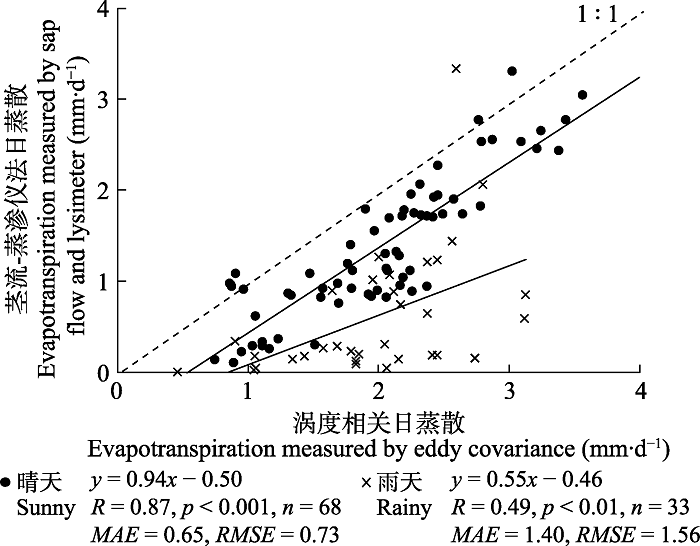 �´��ڴ�|����ԭͼZIP|����PPT
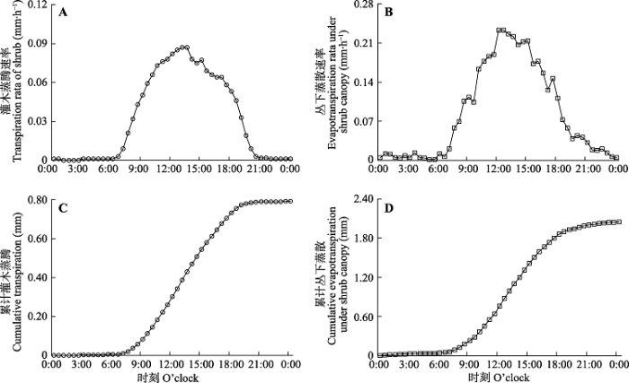 �´��ڴ�|����ԭͼZIP|����PPT
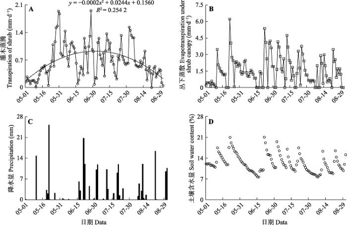 �´��ڴ�|����ԭͼZIP|����PPT
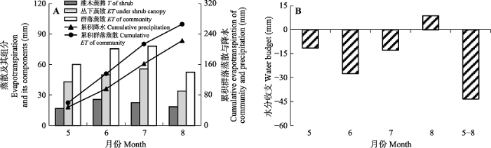 �´��ڴ�|����ԭͼZIP|����PPT

