刘金铜1,,
1.中国科学院遗传与发育生物学研究所农业资源研究中心 石家庄 050022
2.中国科学院大学 北京 100049
基金项目: 国家重点研发计划课题2016YFC0501308
详细信息
作者简介:高惠君, 主要研究方向为脆弱区生态工程。E-mail: 18205482441@163.com
通讯作者:刘金铜, 主要研究方向为生态系统可持续管理与生态工程。E-mail: jtliu@sjziam.ac.cn
中图分类号:S17计量
文章访问数:190
HTML全文浏览量:8
PDF下载量:161
被引次数:0
出版历程
收稿日期:2020-06-19
录用日期:2020-10-09
刊出日期:2021-04-01
Definition of agro-pastoral ecotone in North China based on irrigation corrections
GAO Huijun1, 2,,LIU Jintong1,,
1. Center for Agricultural Resources Research, Institute of Genetics and Developmental Biology, Chinese Academy of Sciences, Shijiazhuang 050022, China
2. University of Chinese Academy of Sciences, Beijing 100049, China
Funds: the National Key Research and Development Project of China2016YFC0501308
More Information
Corresponding author:LIU Jintong, E-mail: jtliu@sjziam.ac.cn
摘要
HTML全文
图
参考文献
相关文章
施引文献
资源附件
访问统计
摘要
摘要:我国北方农牧交错带为典型生态脆弱带,对其科学合理的界定对基于资源利用的区域可持续发展具有重要意义。北方农牧交错带界定的最基本条件是水分条件,但是前人的界定均以降水作为水分条件,均没考虑灌溉对农牧交错带形成的影响。本研究在传统界定方法的基础上,增加了灌溉条件订正,以订正后的水分条件作为界定指标,并结合水分变率和干燥度指标,运用模糊综合评判法,对北方农牧交错带进行界定,并进一步结合行政边界进行农牧交错带县域的划分。结果显示,我国北方农牧交错带呈东北—西南走向的带状分布,总面积65.90万km2;北方农牧交错带县(市、旗)共有123个,总面积66.08万km2,分布于北方的9个省(自治区),农牧交错带县数量以内蒙古自治区、山西省和青海省居多,农牧交错带县总面积以内蒙最大。本研究的界定结果在位置上比农业部指定范围略向西北方向偏移,范围上分别向东北和西南扩展,增加了黑龙江、吉林、青海3个省份,去掉了辽宁省;在县域总数上有所减少,黑龙江、吉林、内蒙古、青海的农牧交错带县域(市、旗)总数有所增加,而河北、山西、陕西、甘肃、宁夏的农牧交错带县域(市)总数有所减少;部分位于内蒙河套灌区和宁夏河套灌区的县域被划入。由对农牧交错带水热条件的分析可知,农牧交错带大部分地区的年积温为2000~3500℃,空间上呈中间高,东北、西南低的趋势;大部分地区的水分条件(降水和灌溉)为300~450 mm,空间上沿东南—西北方向递减;大部分地区的表层土壤有机碳含量为0~1%,空间上呈中间低,东北、西南高的趋势。本研究将灌溉指标纳入农牧交错带的界定指标系统,弥补了传统气候界定方法的缺陷,是对农牧交错带界定工作的科学补充和发展,得到的县域尺度的农牧交错带结合农牧交错带水热条件分布研究,可为农牧交错带区域农牧结构调整和精准可持续发展提供科学借鉴。
关键词:中国北方/
农牧交错带/
界定/
灌溉订正/
水分条件/
河套灌区
Abstract:The agro-pastoral ecotone in North China is a typical ecologically fragile zone. Scientific and reasonable definitions are important for the sustainable development of regions based on resource utilization. The water conditions are the most basic conditions to define the agro-pastoral ecotone in North China. Previous studies used precipitation as the water condition and did not consider the impact of irrigation. Based on the traditional method, this study incorporated irrigation corrections and used the corrected water condition, combined with the water variability and dryness indicators and with support of the fuzzy comprehensive evaluation method, to define the agro-pastoral ecotone in North China. Subsequently, this study also combined the administrative boundaries to divide the counties in the agro-pastoral ecotone. The results show that the agro-pastoral ecotone in North China presents a banded distribution in the northeast-southwest direction, with a total area of 659 000 km2. There are 123 counties (cities, banners) in the agro-pastoral ecotone, with a total area of 660 800 km2, distributed across nine provinces (autonomous regions) in North China. The number of counties is highest in the Inner Mongolia Autonomous Region, Shanxi Province, and Qinghai Province, and the total area of the counties is the largest in the Inner Mongolia Autonomous Region. The results of this study shift slightly northwest of the range designated by the Ministry of Agriculture and extend northeast and southwest, respectively, in scope. Three provinces, Heilongjiang, Jilin, and Qinghai, were added, while Liaoning Province was removed. There has been a decrease in the total number of counties. The total number of counties (cities, banners) in the agro-pastoral ecotone in Heilongjiang, Jilin, Inner Mongolia, and Qinghai increased, while the total number of counties (cities) in the agro-pastoral ecotone in Hebei, Shanxi, Shaanxi, Gansu, and Ningxia decreased. Some counties in the Inner Mongolia Hetao Irrigation District and Ningxia Hetao Irrigation District were included. Analysis of the hydrothermal conditions in the agro-pastoral ecotone show that the annual accumulated temperature in most areas is between 2000-3500 ℃, with high temperatures in the middle and low temperatures in the northeast and southwest. The water conditions (precipitation and irrigation) in most areas of the agro-pastoral ecotone are in the range of 300-450 mm, decreasing in the southeast-northwest direction. The content of topsoil organic carbon in most areas is between 0 and 1%, with low values in the middle and high values in the northeast and southwest. This study incorporates irrigation indicators into the definition index system of the agro-pastoral ecotone, which compensates for the shortcomings of the traditional climate definition method and is a scientific supplement to the definition of the agro-pastoral ecotone. The obtained county-scale agro-pastoral ecotone can provide a scientific reference to adjust the agricultural-pastoral structure for precise sustainable development of the agro-pastoral ecotone if combined with the hydrothermal conditions.
Key words:North China/
Agro-pastoral ecotone/
Definition/
Irrigation corrections/
Water condition/
Hetao Irrigation District
HTML全文
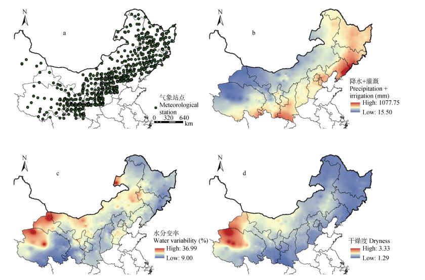
图1研究区613个气象站点分布(a)和1981—2010年的年均水分条件(灌溉订正后的降水)(b)、水分变率(c)和干燥度(d)的空间分布
Figure1.Spatial distribution of 613 meteorological stations (a) and average annual water conditions (precipitation modified with irrigation, b), water variability (c) and dryness (d) from 1981 to 2010 in the study area
 下载: 全尺寸图片幻灯片
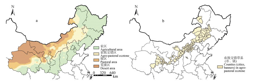
图2北方农牧交错带划分结果(a)和北方农牧交错带县(市、旗)分布(b)
Figure2.Agro-pastoral ecotone in North China (a) and distribution of counties (cities, banners) in agro-pastoral ecotone in North China (b) defined in this paper
下载: 全尺寸图片幻灯片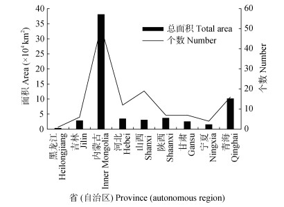
图3各省(区)北方农牧交错带县(市、旗)总面积及个数
Figure3.Total area and number of counties (cities, banners) in agro-pastoral ecotone in North China in each province (autonomous region)
下载: 全尺寸图片幻灯片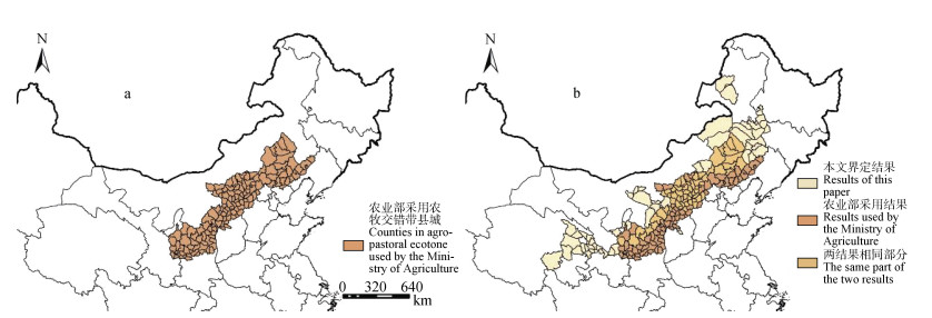
图4农业部按产业要求指定的北方农牧交错带县域分布图(a)和本文界定结果与农业农村部指定范围叠加图(b)
Figure4.Distribution of counties in agro-pastoral ecotone in North China designated by the Ministry of Agriculture according to industry requirements (a) and difference between it and results of this paper (b)
下载: 全尺寸图片幻灯片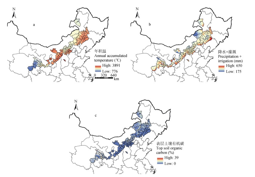
图5北方农牧交错带的年积温(a)、水分条件(降水+灌溉, b)和表层土壤有机碳(c)分布
Figure5.Distribution of annual accumulated temperature (a), water conditions (precipitation + irrigation, b) and top soil organic carbon (c) in the identified agro-pastoral ecotone in North China
下载: 全尺寸图片幻灯片表1用于确定北方农牧交错带界定指标权重的判断矩阵
Table1.Judgment matrix used to determine the weight of the defined indexes for definition of agro-pastoral ecotone in North China
| C1 | C2 | C3 | 权重 Weight | |
| 水分条件?Water condition (C1) | 1 | 6 | 8 | 0.75 |
| 水分变率?Water variability (C2) | 1/6 | 1 | 3 | 0.17 |
| 干燥度?Dryness (C3) | 1/8 | 1/3 | 1 | 0.08 |
| 表中数据, 1表示两个元素具有同等重要性; 3表示两个元素相比, 前者比后者稍重要; 5表示两个元素相比, 前者比后者明显重要; 7表示两个元素相比, 前者比后者极其重要; 9表示两个元素相比, 前者比后者强烈重要; 2、4、6、8表示上述相邻判断的中间值; 倒数则表示相反的结果。In the table, “1” means equally important of the two elements; “3” means slightly more important of the former element than the latter one; “5” means obviously more important of the former element than the latter one; “7” means strongly more important of the former element than the latter one; “9” means extremely more important of the former element than the latter one; “2”, “4”, “6”, “8” represent the intermediate values of the above adjacent judgment. The reciprocal means inverse importance between two elements. | ||||
下载: 导出CSV表2用于计算隶属度的北方农牧交错带界定指标临界值
Table2.Critical value of each defined index for definition of agro-pastoral ecotone in North China used to calculate the degree of membership
| 界定指标 Defining index (x) | a4 | a3 | a2 | a1 |
| 水分条件?Water condition (mm) | 225 | 300 | 375 | 450 |
| 水分变率?Water variability (%) | 15.0 | 22.5 | 30.0 | 37.5 |
| 干燥度?Dryness | 1.250 | 1.625 | 2.000 | 2.375 |
下载: 导出CSV表3各省(自治区)内北方农牧交错带县(市、旗)分布情况
Table3.Distribution of counties (cities, banners) in agro-pastoral ecotone in North China in each province (autonomous region) defined in this paper
| 所属省(区) Province (region) | 所含县(市、旗) Included counties (cities, banners) |
| 黑龙江省 Heilongjiang Province | 泰来县 Tailai County |
| 吉林省 Jilin Province | 洮北区、洮南市、镇赉县、乾安县、大安市、通榆县 Taobei District, Taonan City, Zhenlai County, Qian’an County, Da’an City, Tongyu County |
| 内蒙古自治区 Inner Mongolia Autonomous Region | 赤峰市、陈巴尔虎旗、东乌珠穆沁旗、乌兰浩特市、突泉县、科尔沁右翼中旗、霍林郭勒市、扎鲁特旗、西乌珠穆沁旗、阿鲁科尔沁旗、巴林左旗、科尔沁左翼中旗、巴林右旗、林西、克什克腾旗、开鲁县、科尔沁区、科尔沁左翼后旗、奈曼旗、翁牛特旗、正蓝旗、正镶白旗、敖汉旗、多伦县、喀喇沁旗、太仆寺旗、察哈尔右翼后旗、察哈尔右翼中旗、兴和县、五原县、临河区、卓资县、察哈尔右翼前旗、呼和浩特市、集宁区、土默特左旗、土默特右旗、凉城县、丰镇市、和林格尔县、托克托县、准格尔旗、清水河县、鄂尔多斯市、伊金霍洛旗、乌审旗、磴口县、杭锦旗、库伦旗、海拉尔区、鄂温克族自治旗 Chifeng City, Chen Barag Banner, Dong Ujimqin Banner, Ulan Hot City, Tuquan County, Horqin Right Wing Middle Banner, Holin Gol City, Jarud Banner, Xi Ujimqin Banner, Ar Horqin Banner, Bairin Left Banner, Horqin Left Middle Banner, Bairin Right Banner, Linxi County, Hexigten Banner, Kailu County, Horqin District, Horqin Left Wing Rear Banner, Naiman Banner, Ongniud Banner, Zhenglan Banner, Zhengxiangbai Banner, Aohan Banner, Duolun County, Harqin Banner, Taibus Banner, Qahar Right Wing Rear Banner, Qahar Right Wing Middle Banner, Xinghe County, Wuyuan County, Linhe District, Zhuozi County, Qahar Right Wing Front Banner, Hohhot City, Jining District, Tumd Left Banner, Tumd Right Banner, Liangcheng County, Fengzhen City, Horinger County, Togtoh County, Jungar Banner, Qingshuihe County, Erdousi City, Ejin Horo Banner, Uxin Banner, Dengkou County, Hanggin Banner, Hure Banner, Haila’er District, Ewenki Autonomous Banner |
| 河北省 Hebei Province | 围场满族蒙古族自治县、康保县、沽源县、尚义县、怀安县、阳原县、蔚县、张家口市、万全区、张北县、崇礼县、涿鹿县 Manchu-Mongolian Autonomous County of Weichang, Kangbao County, Guyuan County, Shangyi County, Huai’an County, Yangyuan County, Yuxian County, Zhangjiakou City, Wanquan District, Zhangbei County, Chongli County, Zhuolu County |
| 山西省 Shanxi Province | 天镇县、阳高县、大同市、右玉县、左云县、云州区、怀仁县、广灵县、浑源县、山阴县、应县、灵丘县、河曲县、代县、文水县、平遥县、保德县、朔城区、平鲁区 Tianzhen County, Yanggao County, Datong City, Youyu County, Zuoyun County, Yunzhou District, Huairen County, Guangling County, Hunyuan County, Shanyin County, Ying County, Lingqiu County, Hequ County, Daixian County, Wenshui County, Pingyao County, Baode County, Shuocheng District, Pinglu District |
| 陕西省 Shaanxi Province | 榆阳区、横山县、靖边县、吴起县、定边县、府谷县、神木市 Yuyang District, Hengshan County, Jingbian County, Wuqi County, Dingbian County, Fugu County, Shenmu City |
| 甘肃省 Gansu Province | 会宁县、永靖县、定西县、临洮县、东乡族自治县、积石山保安族东乡族撒拉族自治县、环县 Huining County, Yongjing County, Dingxi County, Lintao County, Dongxiang Autonomous County, Bonan-Dongxiang-Salar Autonomous County of Jishishan, Huan County |
| 宁夏回族自治区 Ningxia Hui Autonomous Region | 青铜峡市、海原县、灵武市、中卫市 Qingtongxia City, Haiyuan County, Lingwu City, Zhongwei City |
| 青海省 Qinghai Province | 刚察县、海晏县、大通回族土族自治县、互助土族自治县、共和县、乐都区、平安区、民和回族土族自治县、兴海县、贵南县、循化撒拉族自治县、同仁县、玛多县、贵德县、尖扎县、化隆回族自治县 Gangca County, Haiyan County, Hui-Tu Autonomous County of Datong, Tu Autonomous County of Huzhu, Gonghe County, Ledu District, Ping’an District, Hui-Tu Autonomous County of Minhe, Xinghai County, Guinan County, Salar Autonomous County of Xunhua, Tongren County, Madoi County, Guide County, Jianzha County, Hui Autonomous County of Hualong |
下载: 导出CSV表4本研究划分结果相对于农业部指定范围的调整
Table4.Adjustment of the results of this study with respect to the range designated by the Ministry of Agriculture
| 省(区) Province (Region) | 总数(增减数) Total (number of increase or decrease) | 更改内容 Content changed |
| 黑龙江省 Heilongjiang Province | 1(+1) | 新增泰来县?Added Tailai County |
| 吉林省 Jilin Province | 6(+6) | 新增洮北区、洮南市、镇赉县、乾安县、大安市、通榆县为农牧交错带县(市) Added Taobei District, Taonan City, Zhenlai County, Qian’an County, Da’an City, Tongyu County |
| 辽宁省 Liaoning Province | 0(-8) | 剔除朝阳县、北票市、凌源市、喀拉沁左翼蒙古族自治县、建平县、彰武县、阜新蒙古族自治县、义县等8个县(市) Exclude 8 counties (cities) including Chaoyang County, Beipiao City, Lingyuan City, Harqin Left Wing Mongolian Autonomous County, Jianping County, Zhangwu County, Fuxin Mongolian Autonomous County, Yi County |
| 内蒙古自治区 Inner Mongolia Autonomous Region | 51(+22) | 新增赤峰市、陈巴尔虎旗、东乌珠穆沁旗、乌兰浩特市、突泉县、科尔沁右翼中旗、霍林郭勒市、扎鲁特旗、西乌珠穆沁旗、科尔沁左翼中旗、开鲁县、科尔沁区、科尔沁左翼后旗、奈曼旗、正蓝旗、正镶白旗、五原县、临河区、呼和浩特市、准格尔旗、鄂尔多斯市、伊金霍洛旗、乌审旗、磴口县、杭锦旗、库伦旗、海拉尔区、鄂温克族自治旗; 剔除武川县、固阳县、松山区、宁城县、化德县、商都县等6个县(市) Added 28 counties (cities, autonomous or banners) including Chifeng City, Chen Barag Banner, Dong Ujimqin Banner, Ulan Hot City, Tuquan County, Horqin Right Wing Middle Banner, Holin Gol City, Jarud Banner, Xi Ujimqin Banner, Horqin Left Wing Middle Banner, Kailu County, Horqin District, Horqin Left Wing Rean Banner, Naiman Banner, Zhenglan Banner, Zhengxiangbai Banner, Wuyuan County, Linhe District, Hohhot City, Jungar Banner, Erdousi City, Ejin Horo Banner, Uxin Banner, Dengkou County, Hanggin Banner, Hure Banner, Hailar District, Ewenki Autonomous Banner. Exclude 6 counties (districts) including Wuchuan County, Guyang County, Songshan District, Ningcheng County, Huade County, Shangdu County |
| 河北省 Heibei Province | 12(-14) | 新增张家口市为农牧交错带市; 剔除双滦区、双桥区、隆化县、承德县、滦平县、平泉县、宽城满族自治县、丰宁满族自治县、御道口牧场、宣化县、下花园区、怀来县、赤城县、涞源县等14个县(市) Added Zhangjiakou City; Exclude 14 counties (districts) including Shuangluan District, Shuangqiao District, Longhua County, Chengde County, Luanping County, Pingquan County, Kuancheng Manchu Autonomous County, Manchu Autonomous County of Fengning, Yudaokou Rangeland, Xuanhua County, Xiahuayuan District, Huailai County, Chicheng County, Laiyuan County |
| 山西省 Shanxi Province | 19(-17) | 新增大同市、云州区、文水县、平遥县为农牧交错带县(市); 剔除娄烦县、南郊区、新荣区、大同县、忻府区、原平市、定襄县、五台县、繁峙县、宁武县、神池县、偏关县、五寨县、岢岚县、静乐县、离石区、岚县、方山县、交城县、兴县、临县等21个县(市) Added 4 counties (districts, cities) including Datong City, Yunzhou District, Wenshui County, Pingyao County. Exclude 21 counties (districts, cities) including Loufan County, Nanjiao District, Xinrong District, Datong County, Xinfu District, Yuanping City, Dingxiang County, Wutai County, Fanzhi County, Ningwu County, Shenchi County, Pianguan County, Wuzhai County, Kelan County, Jingle County, Lishi District, Lan County, Fangshan County, Jiaocheng County, Xing County, Lin County |
| 陕西省 Shaanxi Province | 7(-18) | 剔除绥德县、米脂县、佳县、吴堡县、清涧县、子洲县、宝塔区、延长县、延川县、子长县、安塞县、志丹县、甘泉县、富县、宜川县、黄龙县、洛川县、黄陵县等18个县(市) Exclude 18 counties (districts) including Suide County, Mizhi County, Jia County, Wubu County, Qingjian County, Zizhou County, Baota District, Yanchang County, Yanchuan County, Zichang County, Ansai County, Zhidan County, Ganquan County, Fu County, Yichuan County, Huanglong County, Luochuan County, Huangling County |
| 甘肃省 Gansu Province | 7(-7) | 新增会宁县、永靖县、定西县、临洮县、东乡族自治县、积石山保安族东乡族撒拉族自治县为农牧交错带县; 剔除华池县、庆城县、合水县、正宁县、宁县、镇原县、崆峒区、泾川县、崇信县、灵台县、庄浪县、华亭县、静宁县等13个农牧交错带县(市) Added 6 counties including Huining County, Yongjing County, Dingxi County, Lintao County, Dongxiang Autonomous County, Bonan-Dongxiang-Salar Autonomous County of Jishishan. Exclude 13 counties (districts) including Huachi County, Qingcheng County, Heshui County, Zhengning County, Ning County, Zhenyuan County, Kongtong District, Jingchuan County, Chongxin County, Lingtai County, Zhuanglang County, Huating County, Jingning County |
| 宁夏回族自治区 Ningxia Hui Autonomous Region | 4(-5) | 新增青铜峡市、灵武市、中卫市为农牧交错带市; 剔除原州区、西吉县、彭阳县、隆德县、泾源县、红寺堡区、盐池县、同心县等8个农牧交错带县(市) Add 3 cities including Qingtongxia City, Lingwu City, Zhongwei City. Exclude 8 counties (districts) including Yuanzhou District, Xiji County, Pengyang County, Longde County, Jingyuan County, Hongsibu District, Yanchi County, Tongxin County |
| 青海省 Qinghai Province | 16(+16) | 新增刚察县、海晏县、大通回族土族自治县、互助土族自治县、共和县、乐都区、平安区、民和回族土族自治县、兴海县、贵南县、循化撒拉族自治县、同仁县、玛多县、贵德县、尖扎县、化隆回族自治县为农牧交错带县(市) Add 16 counties (disticts) including Gangcha County, Haiyan County, Hui-Tu Autonomous County of Datong, Tu Autonomous County of Huzhu, Gonghe County, Ledu District, Ping’an District, Hui-Tu Autonomous County of Minhe, Xinghai County, Guinan County, Salar Autonomous County of Xunhua, Tongren County, Madoi County, Guide County, Jianzha County, Hui Autonomous County of Hualong |
下载: 导出CSV参考文献
| [1] | 赵松乔. 察北、察盟及锡盟—一个农牧过渡地区的经济地理调查[J]. 地理学报, 1953, 19(1): 43-60 https://www.cnki.com.cn/Article/CJFDTOTAL-DLXB195301006.htm ZHAO S Q. Chabei, Chameng and Ximeng: An economic geographical investigation of the transitional area of agriculture and animal husbandry[J]. Acta Geographica Sinica, 1953, 19(1): 43-60 https://www.cnki.com.cn/Article/CJFDTOTAL-DLXB195301006.htm |
| [2] | 赵军, 李霞. 中国农牧交错带研究进展[J]. 草业科学, 2009, 26(1): 94-99 doi: 10.3969/j.issn.1001-0629.2009.01.018 ZHAO J, LI X. Research progress on the farming-pastoral ecotone in China[J]. Pratacultural Science, 2009, 26(1): 94-99 doi: 10.3969/j.issn.1001-0629.2009.01.018 |
| [3] | 李世奎, 侯光良, 欧阳海, 等. 中国农业气候资源和农业气候区划[M]. 北京: 科学出版社, 1988 LI S K, HOU G L, OUYANG H, et al. China's Agroclimatic Resources and Agroclimatic Regionalization[M]. Beijing: Science Press, 1988 |
| [4] | 朱震达, 刘恕, 杨有林. 试论中国北方农牧交错地区沙漠化土地整治的可能性和现实性[J]. 地理科学, 1984, 4(3): 197-206 https://www.cnki.com.cn/Article/CJFDTOTAL-DLKX198403000.htm ZHU Z D, LIU S, YANG Y L. The possibilities and realities on re-management of desertified lands in the inter-distributing areas for agricultural and graziery practices in Northern China[J]. Scientia Geographica Sinica, 1984, 4(3): 197-206 https://www.cnki.com.cn/Article/CJFDTOTAL-DLKX198403000.htm |
| [5] | 王静爱, 徐霞, 刘培芳. 中国北方农牧交错带土地利用与人口负荷研究[J]. 资源科学, 1999, 21(5): 19-24 doi: 10.3321/j.issn:1007-7588.1999.05.003 WANG J A, XU X, LIU P F. Landuse and land carrying capacity in ecotone between agriculture and animal husbandry in northern China[J]. Resources Science, 1999, 21(5): 19-24 doi: 10.3321/j.issn:1007-7588.1999.05.003 |
| [6] | 周道纬, 卢文喜, 夏丽华, 等. 北方农牧交错带东段草地退化与水土流失[J]. 资源科学, 1999, 21(5): 57-61 doi: 10.3321/j.issn:1007-7588.1999.05.010 ZHOU D W, LU W X, XIA L H, et al. Grassland degradation and soil erosion in the eastern ecotone between agriculture and animal husbandry in Northern China[J]. Resources Science, 1999, 21(5): 57-61 doi: 10.3321/j.issn:1007-7588.1999.05.010 |
| [7] | 赵哈林, 周瑞莲, 张铜会, 等. 我国北方农牧交错带的草地植被类型、特征及其生态问题[J]. 中国草地, 2003, 25(3): 1-8 https://www.cnki.com.cn/Article/CJFDTOTAL-ZGCD200303001.htm ZHAO H L, ZHOU R L, ZHANG T H, et al. Range vegetation, and its characteristics, ecological-problems in the northern agri-pastoral transition zone, China[J]. Grassland of China, 2003, 25(3): 1-8 https://www.cnki.com.cn/Article/CJFDTOTAL-ZGCD200303001.htm |
| [8] | 战金艳, 邓祥征, 岳天祥, 等. 内蒙古农牧交错带土地利用变化及其环境效应[J]. 资源科学, 2004, 26(5): 80-88 doi: 10.3321/j.issn:1007-7588.2004.05.012 ZHAN J Y, DENG X Z, YUE T X, et al. Land use change and its environmental effects in the farming-pasturing interlocked areas of Inner Mongolia[J]. Resources Science, 2004, 26(5): 80-88 doi: 10.3321/j.issn:1007-7588.2004.05.012 |
| [9] | 杨微, 徐艳. 基于沙漠化和适宜性的农牧交错带土地利用优化研究—以内蒙古科尔沁左翼后旗为例[J]. 中国农业大学学报, 2018, 23(3): 95-105 https://www.cnki.com.cn/Article/CJFDTOTAL-NYDX201803013.htm YANG W, XU Y. Optimization of land-use structure in the farming-grazing transitional zone based on desertification status and land adaptability: A case study of Horqin Left Wing Rear Banner, Inner Mongolia[J]. Journal of China Agricultural University, 2018, 23(3): 95-105 https://www.cnki.com.cn/Article/CJFDTOTAL-NYDX201803013.htm |
| [10] | 周立三, 孙颔, 沈煜青, 等. 中国综合农业区划[M]. 北京: 农业出版社, 1981 ZHOU L S, SUN H, SHEN Y Q, et al. Comprehensive Agricultural Regionalization in China[M]. Beijing: Agriculture Press, 1981 |
| [11] | 朱震达, 刘恕. 中国北方地区的沙漠化过程及其治理区划[M]. 北京: 中国林业出版社, 1981 ZHU Z D, LIU S. Process of Desertification in Northern China and its Control Zoning[M]. Beijing: China Forestry Press, 1981 |
| [12] | 中国自然资源研究会. 中国干旱半干旱地区自然资源研究[M]. 北京: 科学出版社, 1988 Natural Resources Research Association of China. Research on Natural Resources in Arid and Semi-arid Areas of China[M]. Beijing: Science Press, 1988 |
| [13] | 全国农业区划委员会. 中国农业自然资源和农业区划[M]. 北京: 农业出版社, 1991: 58-59 National Agricultrual Zoning Commission in China. Agricultural Natural Resources and Agricultural Regionalization in China[M]. Beijing: Agriculture Press, 1991: 58-59 |
| [14] | 张丕远. 中国历史气候变化[M]. 济南: 山东科学技术出版社, 1996 ZHANG P Y. China's Climate Historical Change[M]. Jinan: Shandong Science and Technology Press, 1996 |
| [15] | 苏桂武, 张林源. 中国北方季风边缘区自然灾害环境和成灾过程的特征[J]. 中国沙漠, 1998, 18(1): 1-9 doi: 10.3321/j.issn:1000-694X.1998.01.001 SU G W, ZHANG L Y. Some features about the disaster engendering conditions and the disaster forming process in the monsoon marginal zone in North China[J]. Journal of Desert Research, 1998, 18(1): 1-9 doi: 10.3321/j.issn:1000-694X.1998.01.001 |
| [16] | 赵哈林, 赵学勇, 张铜会, 等. 北方农牧交错带的地理界定及其生态问题[J]. 地球科学进展, 2002, 17(5): 739-747 doi: 10.3321/j.issn:1001-8166.2002.05.017 ZHAO H L, ZHAO X Y, ZHANG T H, et al. Boundary line on agro-pasture zigzag zone in North China and its problems on eco-environment[J]. Advance in Earth Sciences, 2002, 17(5): 739-747 doi: 10.3321/j.issn:1001-8166.2002.05.017 |
| [17] | 吴传钧, 郭焕成. 中国土地利用[M]. 北京: 科学出版社, 1994 WU C J, GUO H C. Land Use in China[M]. Beijing: Science Press, 1994 |
| [18] | 邹亚荣, 张增祥, 周全斌, 等. 农牧交错带土地利用的土壤侵蚀状况分析[J]. 水土保持通报, 2004, 24(5): 35-38 doi: 10.3969/j.issn.1000-288X.2004.05.008 ZOU Y R, ZHANG Z X, ZHOU Q B, et al. Soil erosion status in an ecotone between agriculture and animal husbandry under different land uses[J]. Bulletin of Soil and Water Conservation, 2004, 24(5): 35-38 doi: 10.3969/j.issn.1000-288X.2004.05.008 |
| [19] | YU L X, ZHANG S E, LIU T X, et al. Spatio-temporal pattern and spatial heterogeneity of ecotones based on land use types of Southeastern Da Hinggan Mountains in China[J]. Chinese Geographical Science, 2015, 25(2): 184-197 doi: 10.1007/s11769-014-0671-8 |
| [20] | SHI W J, LIU Y T, SHI X L. Development of quantitative methods for detecting climate contributions to boundary shifts in farming-pastoral ecotone of Northern China[J]. Journal of Geographical Sciences, 2017, 27(9): 1059-1071 doi: 10.1007/s11442-017-1421-5 |
| [21] | 王铮, 张丕远, 刘啸雷, 等. 中国生态环境过渡的一个重要地带[J]. 生态学报, 1995, 15(3): 319-326 doi: 10.3321/j.issn:1000-0933.1995.03.012 WANG Z, ZHANG P Y, LIU X L, et al. On the ecological sensitive zone in China[J]. Acta Ecologica Sinica, 1995, 15(3): 319-326 doi: 10.3321/j.issn:1000-0933.1995.03.012 |
| [22] | 田广金, 史培军. 中国北方长城地带环境考古学的初步研究[J]. 内蒙古文物考古, 1997, (2): 44-51 https://www.cnki.com.cn/Article/CJFDTOTAL-NMWC199702011.htm TIAN G J, SHI P J. A preliminary study of environmental archaeology in the Great Wall of North China[J]. Steppe Cultural Rellcs, 1997, (2): 44-51 https://www.cnki.com.cn/Article/CJFDTOTAL-NMWC199702011.htm |
| [23] | 史德宽. 农牧交错带在持续发展战略中的特殊地位[J]. 草地学报, 1999, 7(1): 17-21 https://www.cnki.com.cn/Article/CJFDTOTAL-CDXU199901002.htm SHI D K. The special role of the borders between farming and ranging regions in the sustainable development strategies[J]. Acta Agrestia Sinica, 1999, 7(1): 17-21 https://www.cnki.com.cn/Article/CJFDTOTAL-CDXU199901002.htm |
| [24] | 韩颖, 侯向阳. 农牧交错带的变迁、划分及管理机制的探讨[J]. 中国农业资源与区划, 2011, 32(5): 31-35 https://www.cnki.com.cn/Article/CJFDTOTAL-ZGNZ201105008.htm HAN Y, HOU X Y. Change, classification and management of agro-pastoral ecotone in North China[J]. Chinese Journal of Agricultural Resources and Regional Planning, 2011, 32(5): 31-35 https://www.cnki.com.cn/Article/CJFDTOTAL-ZGNZ201105008.htm |
| [25] | 陈全功, 张剑, 杨丽娜. 基于GIS的中国农牧交错带的计算和模拟[J]. 兰州大学学报: 自然科学版, 2007, 43(5): 24-28 https://www.cnki.com.cn/Article/CJFDTOTAL-LDZK200705007.htm CHEN Q G, ZHANG J, YANG L N. GIS description of the Chinese ecotone between farming and animal husbandry[J]. Journal of Lanzhou University: Natural Sciences, 2007, 43(5): 24-28 https://www.cnki.com.cn/Article/CJFDTOTAL-LDZK200705007.htm |
| [26] | 刘庆. 青藏高原东部(川西)生态脆弱带恢复与重建研究进展[J]. 资源科学, 1999, 21(5): 81-86 https://www.cnki.com.cn/Article/CJFDTOTAL-ZRZY905.014.htm LIU Q. Advances in research on restoration and rehabilitation of ecotone in eastern Qinghai-Tibetan Plateau (Western Sichuan)[J]. Resources Science, 1999, 21(5): 81-86 https://www.cnki.com.cn/Article/CJFDTOTAL-ZRZY905.014.htm |
| [27] | 袁宏霞, 乌兰图雅, 郝强. 北方农牧交错带界定的研究进展[J]. 内蒙古林业科技, 2014, 40(2): 38-43 https://www.cnki.com.cn/Article/CJFDTOTAL-NMLK201402010.htm YUAN H X, WULAN T Y, HAO Q. Research progress of definition of farming-pastoral zone in Northern China[J]. Journal of Inner Mongolia Forestry Science and Technology, 2014, 40(2): 38-43 https://www.cnki.com.cn/Article/CJFDTOTAL-NMLK201402010.htm |
| [28] | 安玉洁, 赵麦换, 苏柳, 等. 人民治理黄河70年灌溉效益分析[J]. 人民黄河, 2016, 38(12): 24-27 https://www.cnki.com.cn/Article/CJFDTOTAL-RMHH201612007.htm AN Y J, ZHAO M H, SU L, et al. Analysis of irrigation benefits of the Yellow River management in recent 70 Years[J]. Yellow River, 2016, 38(12): 24-27 https://www.cnki.com.cn/Article/CJFDTOTAL-RMHH201612007.htm |
| [29] | 郑圆圆, 郭思彤, 苏筠. 我国北方农牧交错带的气候界线及其变迁[J]. 中国农业资源与区划, 2014, 35(3): 6-13 https://www.cnki.com.cn/Article/CJFDTOTAL-ZGNZ201403003.htm ZHENG Y Y, GUO S T, SU Y. The climate boundary and its change in farming-pastoral ecotone of Northern China[J]. Chinese Journal of Agricultural Resources and Regional Planning, 2014, 35(3): 6-13 https://www.cnki.com.cn/Article/CJFDTOTAL-ZGNZ201403003.htm |
| [30] | 农业部. 农业部《关于北方农牧交错带农业结构调整的指导意见》[J]. 中国食品, 2016, (24): 141-144 https://www.cnki.com.cn/Article/CJFDTOTAL-GNZB201612002.htm Ministry of Agriculture. "Guiding Opinions on the Adjustment of Agricultural Structure in Agro-pastoral Ecotone in North China" of the Ministry of Agriculture[J]. China Food, 2016, (24): 141-144 https://www.cnki.com.cn/Article/CJFDTOTAL-GNZB201612002.htm |
| [31] | 苏志珠, 马义娟, 刘梅. 中国北方农牧交错带形成之探讨[J]. 山西大学学报: 自然科学版, 2003, 26(3): 269-273 https://www.cnki.com.cn/Article/CJFDTOTAL-SXDR200303022.htm SU Z Z, MA Y J, LIU M. Study on the formation of transitional belt between agriculture and animal husbandry in Northern China[J]. Journal of Shanxi University: Natural Science Edition, 2003, 26(3): 269-273 https://www.cnki.com.cn/Article/CJFDTOTAL-SXDR200303022.htm |
| [32] | 肖鲁湘, 张增祥. 农牧交错带边界判定方法的研究进展[J]. 地理科学进展, 2008, 27(2): 104-111 https://www.cnki.com.cn/Article/CJFDTOTAL-DLKJ200802014.htm XIAO L X, ZHANG Z X. Processes on the boundary definition of agro-pastoral zone in China[J]. Progress in Geography, 2008, 27(2): 104-111 https://www.cnki.com.cn/Article/CJFDTOTAL-DLKJ200802014.htm |
