邵景安1, 2,,,
郭跃1, 2,
曹飞1,
谭少军1
1.重庆师范大学地理与旅游学院 重庆 401331
2.三峡库区地表过程与环境遥感重庆市重点实验室 重庆 401331
基金项目: 重庆市差别化农村土地整治技术研发与示范项目KJ-2016003
详细信息
作者简介:李春梅, 主要从事土地资源可持续利用研究。E-mail:1379051896@qq.com
通讯作者:邵景安, 主要从事土地利用与生态过程研究。E-mail:shao_ja2003@sohu.com
中图分类号:S281计量
文章访问数:677
HTML全文浏览量:5
PDF下载量:957
被引次数:0
出版历程
收稿日期:2017-12-03
录用日期:2018-03-07
刊出日期:2018-07-01
Construction potential of high-standard farmland based on landform factors
LI Chunmei1,,SHAO Jing'an1, 2,,,
GUO Yue1, 2,
CAO Fei1,
TAN Shaojun1
1. College of Geography and Tourism, Chongqing Normal University, Chongqing 401331, China
2. Key Laboratory of Surface Processes and Environmental Remote Sensing in the Three Gorges Reservoir Area, Chongqing 401331, China
Funds: the Differentiation Technology R&D and Demonstration in Rural Land Reclamation of Chongqing, ChinaKJ-2016003
More Information
Corresponding author:SHAO Jing'an, E-mail: shao_ja2003@sohu.com
摘要
HTML全文
图
参考文献
相关文章
施引文献
资源附件
访问统计
摘要
摘要:建设高标准农田是科学、高效、可持续利用土地资源的重要方式,建设潜力研究是高标准农田建设的前期基础工作。本文立足重庆市垫江县4个地貌类型区(浅丘低丘区、低中丘区、坪状高丘区、低山及山麓深丘区),借助实地调研、图件和统计数据,从地块尺度构建高标准农田建设潜力评价指标体系,利用熵权法分别计算指标在各地貌类型区的权重,借助综合指数法测算各评价单元建设的潜力得分。结果表明:1)垫江县约80%的基本农田具备建设成高标准农田的潜力,其中:基本具备区占28.57%,稍加整治区占24.13%,全面整治区占26.92%。2)4种地貌类型区建设高标准农田的潜力大小排序为浅丘低丘区>低中丘区≈坪状高丘区>低山及山麓深丘区。3)不同地貌类型区高标准农田建设的限制因子差异较大:浅丘低丘区限制因子是土壤有机质含量、农田防护面积,低中丘区的限制因子是有效土层厚度、土壤有机质含量、灌排条件,坪状高丘区的限制因子是土壤有机质含量、排灌条件、距交通干线距离,低山及山麓深丘区的限制因子是有效土层厚度、土壤有机质含量、pH、排灌条件、农田机耕能力和田块到居民点距离。未来建设高标准农田时,要因地制宜,布设工程应紧密结合不同地貌类型区限制因子和当地农业产业发展方向,聚焦主导产业消除或降低限制因子的作用,进行差别化高标准农田建设。
关键词:高标准农田/
建设潜力/
地貌类型/
限制性因子/
农业产业/
差别化农地整治
Abstract:The construction of high-standard farmland is important for scientific, efficient and sustainable use of land resources, and the potential study is the basic work in the construction of high-standard farmland. In view of the experience and problems in the construction of high-standard farmland during the "12th Five-Year" period, this study hypothesized that "high-standard" not only focused on the quality improvement, but also the enhancement of mechanization and scale of cultivated land. Moreover, differentiation was necessary in planning and design for various natural, social and economy conditions. There are complex and diverse landform types in Chongqing. Driven by the law of regional differentiation, significant differences in social-economy and industrial development arose in space. Thus this article used landforms as the basis for evaluation of high-standard farmland construction potential with Dianjiang County in Chongqing as the research area. The study analyzed the potential of using basic farmlands to build high-standard farmlands and isolated the limiting factors for building high-standard farmlands in different landform types. Hence it was expected that the study will provide the theoretical basis for the planning and construction of new high-standard farmlands in Dianjiang County, Chongqing. Based on the four landform areas of Dianjiang County (shallow and low hill area, low middle hill area, high hill with flat area, and low mountain and deep hill area), we established an index system to evaluate the construction potential of high-standard farmlands. Furthermore, the entropy weight method was used to calculate the weights of indicators in each geographic area. The comprehensive index method was further used to determine the potential score of each evaluation unit. The results showed that:1) about 80% of the basic farmlands in Dianjiang County had the potential to be transformed into high-standard farmlands. Among these, the area basically meeting the construction criteria covered 28.57% of the total basic farmland, the area needing improvement accounted for 24.13%, and the area needing comprehensive renovation made up 26.92%. 2) The potential for the construction of high-standard farmlands in four types of landform was ranked as:shallow and low hill area > low middle hill area ≈ high hill with flat area > low mountain and deep hill area. 3) There were different limiting factors to high-standard farmland construction in different landform areas. The restricting factors in the shallow and low hill area were soil organic matter content and farmland protective acreage. The limitations in low middle hill area were effective soil layer thickness, soil organic matter content, and irrigation and drainage conditions. The restrictive factors in the high hills with flat area were soil organic matter content, irrigation and drainage conditions, and distance of field to main road. The limiting factors in low mountains and deep hill area were effective soil layer thickness, soil organic matter content, pH, irrigation and drainage condition, farmland tractor-plowing ability, and distance of field to residential area. In the planning and implementation of high-standard farmland construction projects, there was need for project layout to be closely developed around different physiognomy type restriction factors and local agricultural industry development direction. At the same time, there was need for project layouts to focus on leading industries and to eliminate or reduce the role of limiting factors, to carry out different high-standard farmland constructions.
Key words:High-standard farmland/
Construction potential/
Landform type/
Limiting factor/
Agricultural industry/
Different farmland consolidation
HTML全文

图1垫江县位置(a)、地形地貌(b)及基本农田所属地貌类型区分布(c)
Figure1.Location (a), landform (b) and landform regionalization of farmland (c) of Dianjiang County
 下载: 全尺寸图片幻灯片
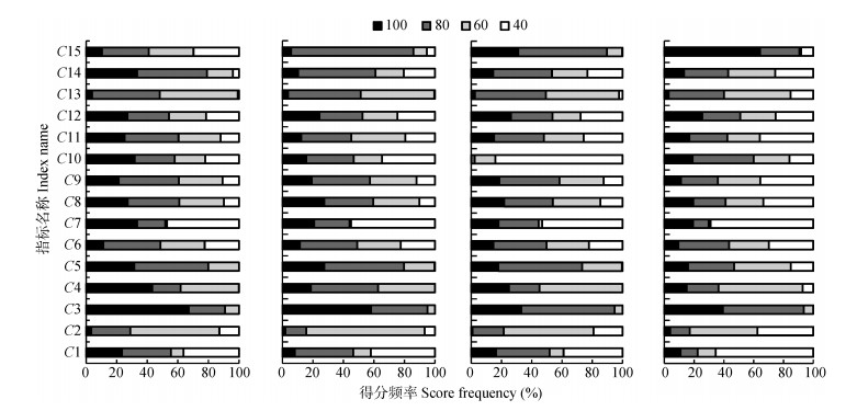
图2垫江县4种地貌类型区[浅丘低丘区(a)、低中丘区(b)、坪状高丘区(c)和低山及山麓深丘区(d)]高标准农田建设潜力指标得分频率统计图
Figure2.Score frequencies of high-standard farmland construction potentiality indexes of four landforms (a: shallow and low hill area; b: low middle hill area; c: high hill with flat area; d: low mountain and deep hill) in Dianjiang County
下载: 全尺寸图片幻灯片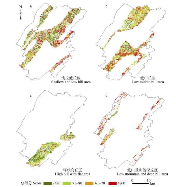
图3垫江县不同地貌类型区高标准农田建设潜力评价得分
Figure3.Evaluation scores of high-standard farmland construction potentiality of different landform areas in Dianjiang County
下载: 全尺寸图片幻灯片表1垫江县现有耕地坡度统计表
Table1.Statistical table of slop of existing farmland in Dianjiang County
| 耕地坡度Cultivated land slope (°) | ||||||||||||
| ≤2 | 2~6 | 6~15 | 15~25 | > 25 | ||||||||
| 占比Proportion (%) | 8 | 15 | 45 | 19 | 13 | |||||||
| 耕地类型Cultivated land type | ||||||||||||
| 梯田 Terraces | 坡地 Hillside field | 梯田 Terrace | 坡地 Hillside field | 梯田 Terrace | 坡地 Hillside field | 梯田 Terrace | 坡地 Hillside field | |||||
| 占比Proportion (%) | 14 | 1 | 19 | 26 | 1 | 18 | 1 | 12 | ||||
下载: 导出CSV表2垫江县4种地貌类型区划分依据及其分布
Table2.Dividing basis and distribution of four landform types in Dianjiang County
| 地貌 Landform | 划分依据Division basis | 主要分布区域 Mainly distribution area | |
| 海拔 Altitude (m) | 相对高差 Relative height difference (m) | ||
| 浅丘低丘区 Shallow and low hill area | < 500 | < 50 | 高滩河沿岸、明月山沿线以东 Gaotan River coast, east of Mountain Moon |
| 低中丘区 Low middle hill area | < 500 | 50~100 | 垫江县北部、鹤大台地周围区域 North Dianjiang County, area around the Heda Tableland |
| 坪状高丘区 High hill with flat area | < 500 | > 100 | 鹤大台地Heda Tableland |
| 低山及山麓深丘区 Low mountain and deep hill area | 500~1 000 | 200~500 | 明月山、南华山、黄草山、大梨山山麓 Mountain Moon, Mountain Nanhua, Mountain Huangcao, foothill of Mountain Dali |
下载: 导出CSV表3高标准农田建设潜力评价指标体系
Table3.Assessment index system of construction potentiality of high-standard farmland
| 目标层 Target layer | 准则层 Rule layer | 指标层 Index layer | 指标类型 Index type | 处理方法 Processing method |
| 高标准农田框架指标 Indicators of high-standard basic farmland framework | 土壤条件 Soil condition | C1有效土层厚度Effective soil layer thickness (cm) | + | — |
| C2土壤有机质含量Soil organic matter content (g·kg-1) | + | — | ||
| C3表层土壤质地Top soil texture | 适宜 Suitable | — | ||
| C4 pH | 适宜 Suitable | — | ||
| 耕作便利条件 (立地条件) Tillage factor (site condition) | C5田块坡度Field slope (°) | - | DEM提取DEM extract | |
| C6集中连片度Aggregation index | + | 缓冲区分析-数据融合 Buffer analysis and data fusion data fusion | ||
| C7排灌条件Irrigation and drainage condition | + | — | ||
| C8田间道路通达度Rode accessibility (%) | + | Near分析Near analysis | ||
| C9田块到居民点距离Distance of field to residential area (m) | - | Near分析Near analysis | ||
| 社会经济条件 Socio-economic condition | C10田块到交通干线距离Distance of field to main road (m) | - | 缓冲区分析Buffer analysis | |
| C12农民人均GDP GDP per farmer (¥ ) | + | — | ||
| C13农田机耕能力Farmland tractor-ploughing ability | + | — | ||
| 农田防护条件 Farmland protection condition | C14林网密度Wood density | 适宜 Suitable | — | |
| C15农田防护面积Farmland protective acreage (%) | + | — |
下载: 导出CSV表4高标准农田建设潜力评价指标分级分值标准
Table4.Grading scores standards of assessment indexes of construction potentiality of high-standard farmland
| 指标 Index | 指标分值Index score | |||
| 40 | 60 | 80 | 100 | |
| C1 (cm) | < 40 | 40~60 | 60~80 | ≥80 |
| C2 (g·kg-1) | < 1.0 | 1.0~1.5 | 1.5~2.0 | ≥2.0 |
| C3 | 砾质土Gravelly soil | 黏土Clay | 砂土Sandy soil | 壤土Loam |
| C4 | ≤5.5或≥9.5 | 5.5~6.0或9.0~9.5 | 6.0~6.5或8.5~9.0 | 6.5~8.5 |
| C5 (°) | > 15° | 10°~15° | 5°~10° | ≤5° |
| C6 | ≤5 | 5~7 | 7~10 | > 10 |
| C7 | < 70 | 70~80 | 80~90 | ≥90 |
| C8 (%) | < 95 | 95~98 | 98~100 | 100 |
| C9 (m) | ≥1 500 | 1 000~1 500 | 500~1 000 | < 500 |
| C10 (m) | ≥2 000 | 1 500~2 000 | 1 000~1 500 | < 1 000 |
| C11 | ≥5 000 | 2 000~5 000 | 1 000~2 000 | < 1 000 |
| C12 (¥) | < 800 | 800~1 200 | 1 200~1 500 | ≥1 500 |
| C13 | 差Poor | 中Medium | 良Good | 优Excellent |
| C14 | — | 紧密型Close type | 舒透型Breathable type | 透风型Drafty type |
| C15 (%) | ≤50 | 50~70 | 70~90 | > 90 |
下载: 导出CSV表5不同地貌类型区高标准农田建设潜力评价指标的权重
Table5.Weights of assessment indexes of construction potentiality of high-standard farmland for different landform areas
| 指标 Index | 浅丘低丘区 Shallow and low hill area | 低中丘区 Low middle hill area | 坪状高丘区 High hill with flat area | 低山及山麓深丘区 Low mountain and deep hill area | |
| 土壤条件 Soil condition | C1 | 0.061 | 0.048 | 0.001 | 0.049 |
| C2 | 0.191 | 0.101 | 0.028 | 0.071 | |
| C3 | 0.071 | 0.179 | 0.061 | 0.124 | |
| C4 | 0.019 | 0.011 | 0.060 | 0.011 | |
| 耕作便利条件 Tillage factor | C5 | 0.020 | 0.013 | 0.061 | 0.013 |
| C6 | 0.004 | 0.003 | 0.060 | 0.004 | |
| C7 | 0.308 | 0.393 | 0.063 | 0.469 | |
| C8 | 0.005 | 0.012 | 0.083 | 0.010 | |
| C9 | 0.001 | 0.010 | 0.083 | 0.005 | |
| 社会经济条件 Location condition | C10 | 0.032 | 0.049 | 0.086 | 0.030 |
| C11 | 0.020 | 0.018 | 0.082 | 0.027 | |
| C12 | 0.002 | 0.002 | 0.082 | 0.003 | |
| C13 | 0.036 | 0.034 | 0.084 | 0.092 | |
| 农田防护条件 Farmland protection conditions | C14 | 0.112 | 0.002 | 0.083 | 0.001 |
| C15 | 0.116 | 0.126 | 0.083 | 0.090 |
下载: 导出CSV表6垫江县高标准农田建设潜力划分标准及划分结果
Table6.Division standard and result of high-standard farmland construction potentiality in Dianjiang County
| 分值 Score value | 高标准农田建设潜力分区 Subdivision of potentiality of high-standard farmland construction | 面积 Area (hm2) | 比例 Proportion (%) |
| ≥80 | A1基本具备区 Subdivision basically meeting the construction criteria | 22 985.71 | 28.57 |
| 70~80 | A2稍加整治区 Subdivision needing improvement | 19 413.55 | 24.13 |
| 60~70 | A3全面整治区 Subdivision needing comprehensive renovation | 21 658.22 | 26.92 |
| < 60 | A4不适宜区 Not suitable area | 16 396.53 | 20.38 |
| 合计Total | 80 454.00 | 100.00 |
下载: 导出CSV表7垫江县不同地貌类型区高标准农田建设潜力统计表
Table7.Statistical table of high-standard farmland construction potentiality in each landform area in Dianjiang County
| 潜力分区 Subdivision of potentiality | 浅丘低丘区 Shallow and low hill area | 低中丘区 Low middle hill area | 坪状高丘区 High hill with flat area | 低山及山麓深丘区 Low mountain and deep hill area | |||||||
| 面积 Area (hm2) | 比例 Proportion (%) | 面积 Area (hm2) | 比例 Proportion (%) | 面积 Area (hm2) | 比例 Proportion (%) | 面积 Area (hm2) | 比例 Proportion (%) | ||||
| A1 | 14 697 | 46.36 | 6 223 | 22.24 | 545 | 4.09 | 1 507 | 20.25 | |||
| A2 | 4 462 | 14.07 | 5 962 | 21.31 | 8 529 | 64.00 | 475 | 6.38 | |||
| A3 | 7 691 | 24.26 | 8 751 | 31.27 | 4 068 | 30.53 | 1 144 | 15.37 | |||
| A4 | 4 854 | 15.31 | 7 046 | 25.18 | 184 | 1.38 | 4 316 | 58.00 | |||
| 合计 Total | 31 704 | 100.00 | 27 982 | 100.00 | 13 326 | 100.00 | 7 442 | 100.00 | |||
下载: 导出CSV表8垫江县各地貌类型区高标准农田建设的优劣因子
Table8.Advantage and limiting factors in each landform area of high-standard farmland construction in Dianjiang County
| 地貌类型区 Landform type | 优势因子 Advantage factor | 限制因子 Limiting factor |
| 浅丘低丘区 Shallow and low hill area | 表层土壤质地、pH、田块坡度、田间道路通达度、田块到居民点距离、林网密度 Surface soil texture, pH, field slope, rode accessibility, distance of field to residential area, forest density | 土壤有机质含量、农田防护面积 Soil organic matter content, farmland protective acreage |
| 低中丘区 Low middle hill area | 表层土壤质地、pH、田块坡度、农田防护面积 Surface soil texture, pH, field slope, farmland protective acreage | 有效土层厚度、土壤有机质含量、排灌条件 Effective soil layer thickness, soil organic matter content, irrigation and drainage condition |
| 坪状高丘区 High hill with flat area | 表层土壤质地、田块坡度、农田防护面积 Surface soil texture, field slope, farmland protective acreage | 土壤有机质含量、排灌条件、距交通干线距离 Soil organic matter content, irrigation and drainage condition, distance of field to main road |
| 低山及山麓深丘区 Low mountain and deep hill area | 表层土壤质地、农田防护面积 Surface soil texture, farmland protective acreage | 有效土层厚度、土壤有机质含量、pH、排灌条件、农田机耕能力、田块到居民点距离 Effective soil layer thickness, soil organic matter content, pH, irrigation and drainage condition, farmland tractor- ploughing ability, distance of field to residential area |
下载: 导出CSV参考文献
| [1] | 中华人民共和国国家质量监督检验检疫总局. GB/T 28407-2012农用地质量分等规程[S]. 北京: 中国标准出版社, 2012 General Administration of Quality Supervision, Inspection and Quarantine of the People's Republic of China (AQSIQ). GB/T 28407-2012 Regulation for Gradation on Agriculture Land Quality[S]. Beijing: China Standard Press, 2012 |
| [2] | 边振兴, 杨子娇, 钱凤魁, 等.基于LESA体系的高标准基本农田建设时序研究[J].自然资源学报, 2016, 31(3):436-446 doi: 10.11849/zrzyxb.20150081 BIAN Z X, YANG Z J, QIAN F K, et al. Study on time sequence of high-standard prime farmland based on LESA[J]. Journal of Natural Resources, 2016, 31(3):436-446 doi: 10.11849/zrzyxb.20150081 |
| [3] | 龙花楼.论土地整治与乡村空间重构[J].地理学报, 2013, 68(8):1019-1028 http://www.cnki.com.cn/Article/CJFDTotal-DLXB201308002.htm LONG H L. Land consolidation and rural spatial restructuring[J]. Acta Geographica Sinica, 2013, 68(8):1019-1028 http://www.cnki.com.cn/Article/CJFDTotal-DLXB201308002.htm |
| [4] | 陈然. 基于GIS的农村土地生态适宜性评价及应用研究——以义乌市岩南村为例[R]. 江苏: 南京农业大学, 2011 CHEN R. Rural land ecological suitability assessment and its application based on GIS: A case study of Yannan Village[R]. Jiangsu: Nanjing Agricultural University, 2011 |
| [5] | 钱凤魁, 王秋兵, 李娜, 等.基于耕地质量与立地条件综合评价的高标准基本农田划定[J].农业工程学报, 2015, 31(18):225-232 doi: 10.11975/j.issn.1002-6819.2015.18.031 QIAN F K, WANG Q B, LI N, et al. High-standard prime farmland planning based on evaluation of farmland quality and site conditions[J]. Transactions of the CSAE, 2015, 31(18):225-232 doi: 10.11975/j.issn.1002-6819.2015.18.031 |
| [6] | TYLER M, HUNTER L, STEINER F, et al. Use of agricultural land evaluation and site assessment in Whitman County, Washington, USA[J]. Environmental Management, 1987, 11(3):407-412 doi: 10.1007/BF01867169 |
| [7] | PA?AKARNIS G, MALIENE V. Towards sustainable rural development in central and eastern Europe:Applying land consolidation[J]. Land Use Policy, 2010, 27(2):545-549 doi: 10.1016/j.landusepol.2009.07.008 |
| [8] | 田玉福.德国土地整理经验及其对我国土地整治发展的启示[J].国土资源科技管理, 2014, 31(1):110-114 http://www.cqvip.com/QK/90709A/201401/48641687.html TIAN Y F. Implications of German land consolidation experience for Chinese land consolidation development[J]. Scientific and Technological Management of Land and Resources, 2014, 31(1):110-114 http://www.cqvip.com/QK/90709A/201401/48641687.html |
| [9] | 伍新木, 杨莹.日本国土开发利用及对我国的启示[J].中国人口·资源与环境, 2006, 16(4):138-142 http://www.wanfangdata.com.cn/details/detail.do?_type=perio&id=zgrkzyyhj200706025 WU X M, YANG Y. Enlightenment of Japan's land utilization to China[J]. China Population, Resources and Environment, 2006, 16(4):138-142 http://www.wanfangdata.com.cn/details/detail.do?_type=perio&id=zgrkzyyhj200706025 |
| [10] | 王东京, 孙浩, 林冰蓓.法国农业现代化之路[J].农村工作通讯, 2012, (18):63-64 http://www.wanfangdata.com.cn/details/detail.do?_type=perio&id=xinny201306037 WANG D J, SUN H, LIN B B. The way of agricultural modernization in France[J]. Rural Work Communication, 2012, (18):63-64 http://www.wanfangdata.com.cn/details/detail.do?_type=perio&id=xinny201306037 |
| [11] | 王晨, 汪景宽, 李红丹, 等.高标准基本农田区域分布与建设潜力研究[J].中国人口·资源与环境, 2014, 24(S2):226-229 http://www.cnki.com.cn/Article/CJFDTotal-ZGRZ2014S2056.htm WANG C, WANG J K, LI H D, et al. Research on regional distribution and potentiality of high-standard basic farmland[J]. China Population, Resources and Environment, 2014, 24(S2):226-229 http://www.cnki.com.cn/Article/CJFDTotal-ZGRZ2014S2056.htm |
| [12] | 崔勇, 刘志伟.基于GIS的北京市怀柔区高标准基本农田建设适宜性评价研究[J].中国土地科学, 2014, 28(9):76-81 http://www.cnki.com.cn/Article/CJFDTOTAL-ZTKX201409011.htm CUI Y, LIU Z W. A GIS-based approach for suitability evaluation of high standard primary farmland consolidation:A case from Huairou in Beijing[J]. China Land Sciences, 2014, 28(9):76-81 http://www.cnki.com.cn/Article/CJFDTOTAL-ZTKX201409011.htm |
| [13] | 赵素霞, 牛海鹏, 张捍卫, 等.基于生态位模型的高标准基本农田建设适宜性评价[J].农业工程学报, 2016, 32(12):220-228 doi: 10.11975/j.issn.1002-6819.2016.12.032 ZHAO S X, NIU H P, ZHANG H W, et al. Suitability evaluation on high quality capital farmland consolidation based on niche-fitness model[J]. Transactions of the CSAE, 2016, 32(12):220-228 doi: 10.11975/j.issn.1002-6819.2016.12.032 |
| [14] | 蔡朕, 刁承泰, 王锐, 等.基于集对分析的高标准基本农田建设项目选址合理性评价——以重庆市梁平县为例[J].中国生态农业学报, 2014, 22(7):828-836 http://www.ecoagri.ac.cn/zgstny/ch/reader/view_abstract.aspx?file_no=2014711&flag=1 CAI Z, DIAO C T, WANG R, et al. Evaluation of the reasonability of site selection for high quality capital farmland construction project based on set pair analysis[J]. Chinese Journal of Eco-Agriculture, 2014, 22(7):828-836 http://www.ecoagri.ac.cn/zgstny/ch/reader/view_abstract.aspx?file_no=2014711&flag=1 |
| [15] | 贾丽, 吴冰冰, 高泽崇, 等.高标准基本农田建设时序安排研究——以河北省涿州市为例[J].中国生态农业学报, 2016, 24(9):1265-1274 http://www.ecoagri.ac.cn/zgstny/ch/reader/view_abstract.aspx?file_no=2016914&flag=1 JIA L, WU B B, GAO Z C, et al. Time sequence of high-standard prime farmland construction-A case study of Zhuozhou City, Hebei Province[J]. Chinese Journal of Eco-Agriculture, 2016, 24(9):1265-1274 http://www.ecoagri.ac.cn/zgstny/ch/reader/view_abstract.aspx?file_no=2016914&flag=1 |
| [16] | 冯锐, 吴克宁, 王倩.四川省中江县高标准基本农田建设时序与模式分区[J].农业工程学报, 2012, 28(22):243-251 doi: 10.3969/j.issn.1002-6819.2012.22.034 ENG R, WU K N, WANG Q. Time sequence and mode partition of high-standard prime farmland construction in Zhongjiang County, Sichuan Province[J]. Transactions of the CSAE, 2012, 28(22):243-251 doi: 10.3969/j.issn.1002-6819.2012.22.034 |
| [17] | 边振兴, 刘琳琳, 王秋兵, 等.基于LESA的城市边缘区永久基本农田划定研究[J].资源科学, 2015, 37(11):2172-2178 http://www.wanfangdata.com.cn/details/detail.do?_type=perio&id=zykx201511008 BIAN Z X, LIU L L, WANG Q B, et al. Permanent prime farmland demarcation in urban fringes based on the LESA system[J]. Resources Science, 2015, 37(11):2172-2178 http://www.wanfangdata.com.cn/details/detail.do?_type=perio&id=zykx201511008 |
| [18] | 信桂新, 杨朝现, 杨庆媛, 等.用熵权法和改进TOPSIS模型评价高标准基本农田建设后效应[J].农业工程学报, 2017, 33(1):238-249 doi: 10.11975/j.issn.1002-6819.2017.01.033 XIN G X, YANG C X, YANG Q Y, et al. Post-evaluation of well-facilitied capital farmland construction based on entropy weight method and improved TOPSIS model[J]. Transactions of the CSAE, 2017, 33(1):238-249 doi: 10.11975/j.issn.1002-6819.2017.01.033 |
| [19] | 刘名冲, 刘瑞卿, 张路路, 等.基于粒子群优化投影寻踪模型的土地整治综合效益评价研究[J].土壤通报, 2013, 44(5):1047-1052 http://www.cnki.com.cn/Article/CJFDTOTAL-NYGU201111061.htm LIU M C, LIU R Q, ZHANG L L, et al. Comprehensive benefit evaluation of land consolidation based on projection pursuit model optimized by particle swarm optimization[J]. Chinese Journal of Soil Science, 2013, 44(5):1047-1052 http://www.cnki.com.cn/Article/CJFDTOTAL-NYGU201111061.htm |
| [20] | 杨伟, 谢德体, 廖和平, 等.基于高标准基本农田建设模式的农用地整治潜力分析[J].农业工程学报, 2013, 29(7):219-229 http://www.wanfangdata.com.cn/details/detail.do?_type=perio&id=csjsllyj2014182830 YANG W, XIE D T, LIAO H P, et al. Analysis of consolidation potential of agricultural land based on construction mode of high-standard basic farmland[J]. Transactions of the CSAE, 2013, 29(7):219-229 http://www.wanfangdata.com.cn/details/detail.do?_type=perio&id=csjsllyj2014182830 |
| [21] | 陈轼, 周兴.基于LESA方法的基本农田补划潜力分析——以贵港市覃塘镇为例[J].现代农业科技, 2015, (22):348-350 doi: 10.3969/j.issn.1007-5739.2015.22.199 CHEN S, ZHOU X. Analysis on basic farmland designated fill potential based on LESA method:taking Qintang Town of Guigang City as an example[J]. Modern Agricultural Technology, 2015, (22):348-350 doi: 10.3969/j.issn.1007-5739.2015.22.199 |
| [22] | 龙雨涵, 杨朝现, 程相友, 等.西南丘陵区高标准基本农田建设潜力测算及模式探讨[J].西南师范大学学报:自然科学版, 2014, 39(7):144-150 http://edu.wanfangdata.com.cn/Periodical/Detail/xnsfdxxb201407026 LONG Y H, YANG C X, CHENG X Y, et al. On potential and construction-models of well-facilitated capital farmland construction in the southwest hilly area[J]. Journal of Southwest China Normal University:Natural Science Edition, 2014, 39(7):144-150 http://edu.wanfangdata.com.cn/Periodical/Detail/xnsfdxxb201407026 |
| [23] | 钱凤魁, 张琳琳, 边振兴, 等.高标准基本农田建设中的耕地质量与立地条件评价研究[J].土壤通报, 2015, 46(5):1049-1055 http://www.cqvip.com/QK/91157X/201505/84828466504849534853484852.html QIAN F K, ZHANG L L, BIAN Z X, et al. Farmland natural quality evaluation and site assessment in the high-standard basic farmland construction[J]. Chinese Journal of Soil Science, 2015, 46(5):1049-1055 http://www.cqvip.com/QK/91157X/201505/84828466504849534853484852.html |
| [24] | 王东明. 粮食主产区农户耕地流转行为的影响因素研究[D]. 重庆: 西南大学, 2014 http://cdmd.cnki.com.cn/Article/CDMD-10635-1014261323.htm WANG D M. A study on farm household's willingness of farmland circulation in major grain-producing areas-Based on a survey of Shenqiu County in Henan Province[D]. Chongqing: Southwest University, 2014 http://cdmd.cnki.com.cn/Article/CDMD-10635-1014261323.htm |
| [25] | 罗明. 基于综合质量评价的高标准水田建设研究——以重庆市潼南区为例[D]. 重庆: 西南大学, 2016 http://cdmd.cnki.com.cn/Article/CDMD-10635-1016767071.htm LUO M. Research on the construction of well-facilitied paddy field based on comprehensive quality evaluation: A case study of Tongnan District, Chongqing[D]. Chongqing: Southwest University, 2016 http://cdmd.cnki.com.cn/Article/CDMD-10635-1016767071.htm |
| [26] | 唐秀美, 潘瑜春, 刘玉, 等.基于四象限法的县域高标准基本农田建设布局与模式[J].农业工程学报, 2014, 30(13):238-246 doi: 10.3969/j.issn.1002-6819.2014.13.029 TANG X M, PAN Y C, LIU Y, et al. Layout and mode partition of high-standard basic farmland construction at county level based on four-quadrant method[J]. Transactions of the CSAE, 2014, 30(13):238-246 doi: 10.3969/j.issn.1002-6819.2014.13.029 |
| [27] | 王新盼, 姜广辉, 张瑞娟, 等.高标准基本农田建设区域划定方法[J].农业工程学报, 2013, 29(10):241-250 https://www.wenkuxiazai.com/doc/cb89cf53fc4ffe473268ab2a.html WANG X P, JIANG G H, ZHANG R J, et al. Zoning approach of suitable areas for high quality capital farmland construction[J]. Transactions of the CSAE, 2013, 29(10):241-250 https://www.wenkuxiazai.com/doc/cb89cf53fc4ffe473268ab2a.html |
| [28] | 邱勇.潼南县红棕紫泥夹泥田水稻"3414"肥效试验初报[J].南方农业, 2012, 6(8):28-30 http://edu.wanfangdata.com.cn/Periodical/Detail/nfny-lshyb201204032 QIU Y. The initial report of the fertilizer test of rice "3414" based on red brown purple clay soil in Tongnan County[J]. South China Agriculture, 2012, 6(8):28-30 http://edu.wanfangdata.com.cn/Periodical/Detail/nfny-lshyb201204032 |
| [29] | 邱勇.潼南县红棕紫泥夹泥土小麦"3414"肥效试验初报[J].南方农业, 2013, 7(4):39-41 http://edu.wanfangdata.com.cn/Periodical/Detail/nfny-lshyb201203015 QIU Y. The initial report of the fertilizer test of wheat "3414" based on red brown purple clay soil in Tongnan County[J]. South China Agriculture, 2013, 7(4):39-41 http://edu.wanfangdata.com.cn/Periodical/Detail/nfny-lshyb201203015 |
| [30] | 徐治信.潼南县红棕紫泥夹泥土油菜"3414"肥效试验初报[J].南方农业, 2012, 6(6):30-32 http://edu.wanfangdata.com.cn/Periodical/Detail/nfny-lshyb201204032 XU Z X. The initial report of the fertilizer test of oilseed rape "3414" based on red brown purple clay soil in Tongnan County[J]. South China Agriculture, 2012, 6(6):30-32 http://edu.wanfangdata.com.cn/Periodical/Detail/nfny-lshyb201204032 |
