闫弘文1,,,
赵贤锋2,
孙世清3
1.山东师范大学地理与环境学院 济南 250300
2.烟台市国土资源局 烟台 264003
3.海阳市国土资源局 海阳 265100
基金项目: 山东省海阳市政府采购项目HYHAYT2016-486
详细信息
作者简介:张雅芹, 研究方向为土地评估规划与开发整理。E-mail:2366479731@qq.com
通讯作者:闫弘文, 研究方向为土地评估规划与开发整理。E-mail:preyan@163.com
中图分类号:F301.24计量
文章访问数:875
HTML全文浏览量:2
PDF下载量:541
被引次数:0
出版历程
收稿日期:2017-11-04
录用日期:2018-02-05
刊出日期:2018-07-01
Permanent prime farmland demarcation in city periphery in peninsula hill areas: A case of Haiyang City in Shandong Province
ZHANG Yaqin1,,YAN Hongwen1,,,
ZHAO Xianfeng2,
SUN Shiqing3
1. College of Geography and Environment, Shandong Normal University, Jinan 250300, China
2. Yantai Municipal Bureau of Land and Resources, Yantai 264003, China
3. Haiyang Municipal Bureau of Land and Resources, Haiyang 265100, China
Funds: the Procurement Project of the Haiyang Municipal Government, Shandong Province, ChinaHYHAYT2016-486
More Information
Corresponding author:YAN Hongwen, E-mail: preyan@163.com
摘要
HTML全文
图
参考文献
相关文章
施引文献
资源附件
访问统计
摘要
摘要:基本农田红线是土地利用总体规划“三线”划定的重中之重,城市周边永久基本农田的划定是基本农田红线划定工作中的难点。本研究以半岛丘陵区山东省海阳市为例,以“三线”协同划定的思想为切入点,采用生态优先、建设用地严格举证、优质耕地尽量划入永久基本农田和市场配置资源的思路,将生态安全网络构建、建设用地适宜性评价、耕地质量综合评价等多种方法有机结合,并对土地评价和立地分析(LESA)方法进行改进,通过Arcgis空间分析功能,综合划定海阳市城市周边永久基本农田。结果表明:1)生态安全网络中耕地面积为12.11 hm2,优先建设区与重点建设区中已举证的耕地面积为154.99 hm2,此部分耕地均不适宜划入永久基本农田。2)根据耕地综合质量分值将耕地划分为4个等级,其中,优先划入型和适宜划入型耕地,自然质量和立地条件均比较优越,可划定为永久基本农田,重点调控型和后备资源型耕地则不宜划入;其中优先划入型耕地面积为458.05 hm2,将其中427.82 hm2划入永久基本农田,适宜划入型耕地面积为771.83 hm2,将其中500.67 hm2划入永久基本农田。3)划定后城市周边永久基本农田面积1 305.22 hm2,新划入永久基本农田的耕地面积为928.49 hm2,占城市周边耕地总面积的60.26%,永久基本农田保护率提高了42.66%,永久基本农田中耕地的国家利用等平均值(9.04)高于全市耕地平均利用等别(9.56),且坡度均低于15°。4)城市周边生态安全用地、永久基本农田、建设用地空间布局更加优化,有利于城市的有序发展和土地的可持续利用。本研究采用基于改进的LESA评价方法,并综合考虑生态安全用地、永久基本农田和建设用地的空间布局,丰富了永久基本农田划定方法,达到了海阳市城市周边永久基本农田划定目标;同时研究结果具有较强的实用性,为海阳市永久基本农田的保护和土地利用总体规划“三线”划定工作提供了科学依据。
关键词:半岛丘陵区/
城市周边/
永久基本农田/
生态安全网络/
建设用地适宜性/
耕地自然质量/
LESA体系/
“三线”协同
Abstract:The red lines of prime farmlands constitute the top priority of the "Tri-Line" demarcation of general land use planning. The demarcation of permanent prime farmlands in city periphery has been of great significance for controlling city unlimited sprawl, stabilizing farmland area and ensuring food security of the country. Using Haiyang City in Shandong Province as a case study, this study developed a land planning strategy for the study area based on the "Tri-Line"-coordinating demarcation process. The study adopted procedures of ecological priority, strict construction land evidence, positive demarcation of high-quality cultivated land and market resources allocation to integrate ecological safety network, suitable evaluation of construction land and comprehensive evaluation of cultivated land to demarcate the permanent prime farmland in the study area. To comprehensively evaluate the cultivated land quality, the land evaluation and site assessment (LESA) method was improved, and ArcGIS was used to analyze spatial distribution of cultivated land patch. The results showed that the area of cultivated lands in ecological safety network was 12.11 hm2, and those in the priority construction region and important construction region was 154.99 hm2, both were not suitable for permanent prime farmland. The cultivated land in the city periphery was divided into 4 grades based on comprehensive quality scores. The priority area and suitable area were designated as permanent prime farmland, where the natural quality and site condition were superior. Then the controlled area and reserved area were not included in this division. About 458.05 hm2land was in the priority region, of which 427.82 hm2 of the cultivated land was classified as permanent prime farmland. About 771.83 hm2 land was classified as suitable area, of which 500.67 hm2 was permanent prime farmland. After demarcation, the area of permanent prime farmland around Haiyang City was 1 305.22 hm2, of which newly cultivated land formed 928.49 hm2, accounting for 60.26% of the total cultivated land around the city. Overall, permanent prime farmland protection rate increased by 42.66%. The average use index of cultivated land in permanent prime farmland (9.04) was higher than that of cultivated land in the whole city (9.56), and the slope of the permanent prime farmland was less than 15°. 4) The layout of ecological security land, permanent prime farmland and construction land around the city was more optimized in favor of the orderly development of the city and the sustainable use of the land. In summary, based on the improved LESA evaluation method and comprehensive consideration of layout space of ecological security land, permanent prime farmland and construction land, the study enriched the demarcation method of permanent prime farmlands and achieved permanent prime farmland demarcation in Haiyang City. At the same time, the results of the study were practicable and provided the scientific basis for the protection of permanent prime farmlands and the application of "Tri-Line" demarcation in general land use planning.
Key words:Peninsula hill area/
City periphery/
Permanent prime farmland/
Ecological safety network/
Construction land suitability/
Cultivated land natural quality/
LESA system/
"Tri-Line" coordination
HTML全文

图1海阳市城市周边生态安全网络布局
Figure1.Ecological security network layout of city periphery in Haiyang City
 下载: 全尺寸图片幻灯片
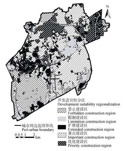
图2海阳市城市周边建设用地适宜性评价分区
Figure2.Zoning map of construction land suitability evaluation in city periphery of Haiyang City
下载: 全尺寸图片幻灯片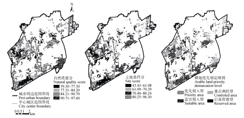
图3海阳市城市周边耕地自然质量(a)、立地条件(b)、土地评价和立地分析(LESA) (c)分值图
Figure3.Score graphs of natural quality (a), site conditions (b), land evaluation and site assessment (LESA) (c) of cultivated land in city periphery of Haiyang City
下载: 全尺寸图片幻灯片
图4海阳市城市周边永久基本农田空间布局
Figure4.Permanent prime farmland layout of city periphery of Haiyang City
下载: 全尺寸图片幻灯片表1海阳市建设用地适宜性评价指标体系
Table1.Index system of construction land suitability evaluation in Haiyang City
| 因子类型 Factor type | 因子 Factor | 类型 Type | 适宜性分值 Suitability score | 权重 Weight |
| 强限制性因子 Strong restrictive factors | 现状基本农田 Current prime farmland | 是Yes | 0 | — |
| 否No | 1 | |||
| 生态红线 Ecological red line | 是Yes | 0 | ||
| 否No | 1 | |||
| 行洪通道 Flood discharge channel | 是Yes | 0 | ||
| 否No | 1 | |||
| 采空塌陷 Goaf collapse | 严重区Serious area | 0 | ||
| 非严重区Non-serious area | 1 | |||
| 较强限制性因子 Secondary strong restrictive factors | 一般农用地 General agriculture land | 高于平均等Above average | 60 | 0.32 |
| 低于平均等Below average | 80 | |||
| 园地、林地、人工草地 Garden, woodland, artificial grassland | 90 | |||
| 其他Others | 100 | |||
| 坡度 Slope (°) | > 15 | 40 | 0.30 | |
| 8~15 | 60 | |||
| 2~8 | 80 | |||
| < 2 | 100 | |||
| 突发地质灾害 Emergency geological hazard | 高High | 40 | 0.20 | |
| 中Medium | 60 | |||
| 低Low | 80 | |||
| 无None | 100 | |||
| 土地利用综合分区 Land use comprehensive zoning | 一般乡镇General township | 50 | 0.18 | |
| 重点乡镇Important township | 70 | |||
| 城区City | 90 |
下载: 导出CSV表2海阳市耕地自然质量评价指标体系
Table2.Index system of cultivated land natural quality evaluation in Haiyang City
| 目标层 Aim layer | 准则层 Criteria layer | 计算方法 Calculation method | 因素作用分 Factor action score | 权重 Weight |
| 自然条件 Natural conditions | 有效土层厚度 Effective soil thickness (cm) | 农用地质量分等规程 Regulation for gradation on agriculture land quality | 分级赋分 Grading assignment | 0.30 |
| 表层土壤质地 Topsoil texture | 农用地质量分等规程 Regulation for gradation on agriculture land quality | 分级赋分 Grading assignment | 0.10 | |
| 障碍层次 Barrier level (cm) | 农用地质量分等规程 Regulation for gradation on agriculture land quality | 分级赋分 Grading assignment | 0.10 | |
| 土壤有机质含量 Soil organic matter content (g·kg-1) | 农用地质量分等规程 Regulation for gradation on agriculture land quality | 分级赋分 Grading assignment | 0.06 | |
| 地形坡度 Terrain slope (°) | 农用地质量分等规程 Regulation for gradation on agriculture land quality | 分级赋分 Grading assignment | 0.21 | |
| 灌溉保证率 Irrigation guarantee rate (%) | 农用地质量分等规程 Regulation for gradation on agriculture land quality | 分级赋分 Grading assignment | 0.23 |
下载: 导出CSV表3海阳市耕地立地条件评价指标体系
Table3.Index system of cultivated land site condition assessment in Haiyang City
| 目标层 Aim layer | 准则层 Criteria layer | 指标层 Index layer | 计算方法 Calculation method | 因素作用分 Factor action score | 权重 Weight |
| 立地条件 Site conditions | 区位条件 Location conditions | 耕地到交通主干道距离 Distance of arable land to main road | GIS缓冲分析 GIS buffering analysis | Fi=1001-r (r=di/d) | 0.13 |
| 耕地到中心城镇距离 Distance of arable land to central town | GIS缓冲分析 GIS buffering analysis | Fi=1001-r (r=di/d) | 0.14 | ||
| 耕地到农村居民点的距离 Distance of arable land to village | GIS缓冲分析 GIS buffering analysis | Fi=1001-r (r=di/d) | 0.12 | ||
| 耕作条件 Tillage conditions | 耕地连片性 Extent of arable land connectivity | GIS缓冲分析 GIS buffering analysis | Fi=100[(Ei-Emin)/(Emax-Emin)] | 0.18 | |
| 农业结构调整可能性 Possibility of agricultural restructure | GIS叠加分析 GIS overlay analysis | 分级赋分Grading assignment | 0.11 | ||
| 耕地斑块形状指数 Index of arable land shape | Esi=4S1/2/L | Fi=100[(Esi-Esimin)/(Esimax-Esimin)] | 0.15 | ||
| 生态条件 Ecological conditions | 生态安全程度 Extent of ecological security | GIS叠加分析 GIS overlay analysis | 分级赋分 Grading assignment | 0.09 | |
| 地质灾害易发程度 Geological hazard susceptibility | GIS叠加分析 GIS overlay analysis | 分级赋分 Grading assignment | 0.08 | ||
| ??Fi为因子i的作用分值, r为相对距离, di为单元距扩散源的实际距离, d为扩散源的影响半径, Ei为缓冲后耕地图斑面积, Esi为耕地斑块形状指数, S为评价单元耕地图斑面积, L为评价单元耕地图斑周长; Esimin和Esimax为耕地斑块形状指数的最小值和最大值。Fi is the effect score of factor i; r is the relative distance; di is the actual distance of the unit from the diffusion source; d is the impact radius of the diffusion source; Ei is the area of cultivated land after buffering; Esi is the morphological index of cultivated land; S is the cultivated land area of the evaluation unit; L is the cultivated land perimeter of the evaluation unit; Esimin and Esimax are the minimum and maximum values of the morphological index of cultivated land. | |||||
下载: 导出CSV表4海阳市城市周边建设用地适宜性评价分区统计
Table4.Zoning statistics of construction land suitability evaluation in city periphery of Haiyang City
| 建设用地类型Construction land type | 地块面积Land area (hm2) | 面积比例Area ratio (%) |
| 禁止建设区Forbidden construction region | 1 414.65 | 19.59 |
| 限制建设区Limited construction region | 803.66 | 11.13 |
| 扩展建设区Extended construction region | 920.99 | 12.76 |
| 重点建设区Important construction region | 3 047.95 | 42.22 |
| 优先建设区Priority construction region | 1 032.65 | 14.30 |
| 合计Total | 7 219.90 | 100.00 |
下载: 导出CSV表5海阳市耕地土地评价和立地分析(LESA)综合评价结果及类型划分
Table5.Comprehensive evaluation results and type classification of land evaluation and site assessment (LESA) in city periphery of Haiyang City
| 耕地类型Cultivated land type | LESA | 地块面积Land area (hm2) | 面积比例Area ratio (%) |
| 优先划入型Priority area | 81.96~93.63 | 458.05 | 25.59 |
| 适宜划入型Suitable area | 75.38~81.95 | 771.83 | 43.12 |
| 重点调控型Controlled area | 68.94~75.37 | 464.44 | 25.94 |
| 后备资源型Reserved area | 55.63~68.93 | 95.73 | 5.35 |
| 总计Total | 1 790.04 | 100.00 |
下载: 导出CSV参考文献
| [1] | 中华人民共和国国务院. 基本农田保护条例[R]. 北京: 中华人民共和国国土资源部, 1998 State Council of the People's Republic of China. The Protection Regulations of Basic Farmland[R]. Beijing: Ministry of Land and Resources of the People's Republic of China, 1998 |
| [2] | 钱凤魁, 王秋兵, 边振兴, 等.永久基本农田划定和保护理论探讨[J].中国农业资源与区划, 2013, 34(3):22-27 doi: 10.7621/cjarrp.1005-9121.20130304 QIAN F K, WANG Q B, BIAN Z X, et al. Discussion about the permanent basic farmaland planning and protection[J]. Chinese Journal of Agricultural Resources and Regional Planning, 2013, 34(3):22-27 doi: 10.7621/cjarrp.1005-9121.20130304 |
| [3] | 郑新奇, 杨树佳, 象伟宁, 等.基于农用地分等的基本农田保护空间规划方法研究[J].农业工程学报, 2007, 23(1):66-71 http://www.cnki.com.cn/Article/CJFDTotal-GDNY201401046.htm ZHENG X Q, YANG S J, XIANG W N, et al. Spatial planning method for the basic farmland protection based on the farmland classification[J]. Transactions of the CSAE, 2007, 23(1):66-71 http://www.cnki.com.cn/Article/CJFDTotal-GDNY201401046.htm |
| [4] | 闫宁, 郑宏刚, 余建新, 等.农用地分等在基本农田划分中的应用研究[J].国土与自然资源研究, 2009, (3):28-30 http://www.cnki.com.cn/Article/CJFDTotal-GDNY201401046.htm YAN N, ZHENG H G, YU J X, et al. Research on applications of agricultural land classification in division of prime farmland[J]. Territory & Natural Resources Study, 2009, (3):28-30 http://www.cnki.com.cn/Article/CJFDTotal-GDNY201401046.htm |
| [5] | 宇向东, 郝晋珉, 鲍文东.基于耕地分等的基本农田空间配置的方法[J].农业工程学报, 2008, 24(S1):185-189 http://www.cnki.com.cn/Article/CJFDTotal-GDNY201401046.htm YU X D, HAO J M, BAO W D. Methods of spatial allocation of basic farmland based on classification of arable land[J]. Transactions of the CSAE, 2008, 24(S1):185-189 http://www.cnki.com.cn/Article/CJFDTotal-GDNY201401046.htm |
| [6] | 张英, 潘瑜春, 曾志炫, 等.基于农用地分等定级的耕地入选基本农田评价比较分析[J].中国土地科学, 2012, 26(3):29-33 http://www.cnki.com.cn/Article/CJFDTOTAL-SYSY201503015.htm ZHANG Y, PAN Y C, ZENG Z X, et al. Comparative assessment on primary farmland zoning based on the farmland gradation programme[J]. China Land Sciences, 2012, 26(3):29-33 http://www.cnki.com.cn/Article/CJFDTOTAL-SYSY201503015.htm |
| [7] | 孔祥斌, 靳京, 刘怡, 等.基于农用地利用等别的基本农田保护区划定[J].农业工程学报, 2008, 24(10):46-51 doi: 10.3321/j.issn:1002-6819.2008.10.010 KONG X B, JIN J, LIU Y, et al. Planning method of the prime farmland protection zone based on farmland utilization grade[J]. Transactions of the CSAE, 2008, 24(10):46-51 doi: 10.3321/j.issn:1002-6819.2008.10.010 |
| [8] | 聂艳, 吴学敏, 何颖, 等.基于产能核算和空间聚类的县级基本农田划定研究[J].长江流域资源与环境, 2014, 23(6):809-815 http://www.wanfangdata.com.cn/details/detail.do?_type=perio&id=cjlyzyyhj201406009 NIE Y, WU X M, HE Y, et al. Demarcation method of prime farmland based on productivity and spatial clustering[J]. Resources and Environment in the Yangtze Basin, 2014, 23(6):809-815 http://www.wanfangdata.com.cn/details/detail.do?_type=perio&id=cjlyzyyhj201406009 |
| [9] | 张英, 潘瑜春, 王依贺, 等.基于农用地经济等别的耕地入选基本农田研究[J].农机化研究, 2012, 34(3):37-40 http://www.cnki.com.cn/Article/CJFDTOTAL-SYSY201503015.htm ZHANG Y, PAN Y C, WANG Y H, et al. Research of selecting basic farmland based on farmland economic grade[J]. Journal of Agricultural Mechanization Research, 2012, 34(3):37-40 http://www.cnki.com.cn/Article/CJFDTOTAL-SYSY201503015.htm |
| [10] | 王欣星, 张安明. XGS决策模型在基本农田划定中的应用研究——以重庆市黔江区石会镇为例[J].农机化研究, 2013, 35(7):217-220 http://kns.cnki.net/KCMS/detail/detail.aspx?filename=njyj201307052&dbname=CJFD&dbcode=CJFQ WANG X X, ZHANG A M. Application of XGS decision-making models in primary farmland zoning:A case of Shihui Town of Qiangjiang District in Chongqing[J]. Journal of Agricultural Mechanization Research, 2013, 35(7):217-220 http://kns.cnki.net/KCMS/detail/detail.aspx?filename=njyj201307052&dbname=CJFD&dbcode=CJFQ |
| [11] | 林超, 马智民.基于CLUE-S模型的临潼区基本农田划定研究[J].测绘与空间地理信息, 2014, 37(1):25-29 http://edu.wanfangdata.com.cn/Periodical/Detail/dbch201401045 LIN C, MA Z M. The research on basic farmland demarcated basedon the CLUE-S model in Lintong District[J]. Geomatics & Spatial Information Technology, 2014, 37(1):25-29 http://edu.wanfangdata.com.cn/Periodical/Detail/dbch201401045 |
| [12] | 钱凤魁, 王秋兵.基于农用地分等和LESA方法的基本农田划定[J].水土保持研究, 2011, 18(2):251-255 http://www.wanfangdata.com.cn/details/detail.do?_type=perio&id=stbcyj201102056 QIAN F K, WANG Q B. Planning method of the prime farmland based on farmland classification and LESA method[J]. Research of Soil and Water Conservation, 2011, 18(2):251-255 http://www.wanfangdata.com.cn/details/detail.do?_type=perio&id=stbcyj201102056 |
| [13] | 边振兴, 刘琳琳, 王秋兵, 等.基于LESA的城市边缘区永久基本农田划定研究[J].资源科学, 2015, 37(11):2172-2178 http://www.wanfangdata.com.cn/details/detail.do?_type=perio&id=zykx201511008 BIAN Z X, LIU L L, WANG Q B, et al. Permanent prime farmland demarcation in urban fringes based on the LESA system[J]. Resources Science, 2015, 37(11):2172-2178 http://www.wanfangdata.com.cn/details/detail.do?_type=perio&id=zykx201511008 |
| [14] | 陈茜, 谢德体, 王三.重庆市城市周边地区划定永久基本农田方法研究[J].土壤, 2016, 48(6):1237-1245 http://www.cqvip.com/QK/81113X/201604/669982538.html CHEN Q, XIE D T, WANG S. Study on demarcating method of permanent prime farmland in periphery of Beibei District of Chongqing City[J]. Soils, 2016, 48(6):1237-1245 http://www.cqvip.com/QK/81113X/201604/669982538.html |
| [15] | 周尚意, 朱阿兴, 邱维理, 等.基于GIS的农用地连片性分析及其在基本农田保护规划中的应用[J].农业工程学报, 2008, 24(7):72-77 http://www.cnki.com.cn/Article/CJFDTotal-NXDH201501020.htm ZHOU S Y, ZHU A X, QIU W L, et al. GIS based connectivity analysis and its application in prime farmland protection planning[J]. Transactions of the CSAE, 2008, 24(7):72-77 http://www.cnki.com.cn/Article/CJFDTotal-NXDH201501020.htm |
| [16] | 汪永丰, 田永中, 徐旭晨, 等.基于栅格数据的基本农田布局研究——以涪陵龙潭镇为例[J].西南大学学报:自然科学版, 2011, 33(6):151-155 http://documents.worldbank.org/curated/en/494771468029345252/E45810V20CHINE00Box385246B00PUBLIC0.doc WANG Y F, TIAN Y Z, XU X C, et al. Distribution of basic farmland based on the grid data-A case study of Longtan Town, Fuling[J]. Journal of Southwest University:Natural Science Edition, 2011, 33(6):151-155 http://documents.worldbank.org/curated/en/494771468029345252/E45810V20CHINE00Box385246B00PUBLIC0.doc |
| [17] | 叶胜, 金贤锋, 何宗, 等.基于TOPSIS算法的基本农田划定关键技术[J].地理空间信息, 2015, 13(6):108-110 http://www.wanfangdata.com.cn/details/detail.do?_type=perio&id=dlkjxx201506035 YE S, JIN X F, HE Z, et al. Key technologies of the delineation of basic farmland based on TOPSIS algorithm[J]. Geospatial Information, 2015, 13(6):108-110 http://www.wanfangdata.com.cn/details/detail.do?_type=perio&id=dlkjxx201506035 |
| [18] | 薄瑞, 张剑, 姜广辉, 等.基于TOPSIS的永久基本农田划定研究——以东营市东营区为例[J].山东农业大学学报:自然科学版, 2017, 48(2):259-263 http://www.qikan.com.cn/magdetails/5F0A3BB7-0FC9-4267-A21F-B41CD603D958/2016/30.html BO R, ZHANG J, JIANG G H, et al. Study on the designation of permanent basic farmland-A case study of Dongying District in Dongying City[J]. Journal of Shandong Agricultural University:Natural Science Edition, 2017, 48(2):259-263 http://www.qikan.com.cn/magdetails/5F0A3BB7-0FC9-4267-A21F-B41CD603D958/2016/30.html |
| [19] | 姚敏, 吴洪涛, 范延平. GIS支持下的城市周边永久基本农田划定潜力分析[J].国土资源信息化, 2016, (3):3-6 http://www.cqvip.com/QK/91974X/201603/669939241.html YAO M, WU H T, FAN Y P. Analysis of the potential demarcation of permanent capital farmland in the urban surrounding space supported by GIS[J]. Land and Resources Informatization, 2016, (3):3-6 http://www.cqvip.com/QK/91974X/201603/669939241.html |
| [20] | 李自力, 余丹丹, 辜超.城市周边永久基本农田划定的实施及研究[J].科技广场, 2015, (9):224-227 http://www.wanfangdata.com.cn/details/detail.do?_type=perio&id=kjgc201509046 LI Z L, YU D D, GU C. Implementation and research of the permanent basic farmland around the city[J]. Science Mosaic, 2015, (9):224-227 http://www.wanfangdata.com.cn/details/detail.do?_type=perio&id=kjgc201509046 |
| [21] | 彭艳丽, 杨静.城市周边永久基本农田划定方法探析——以武汉市为例[J].中国土地, 2015, (9):40-42 http://www.cnki.com.cn/Article/CJFDTOTAL-KJIG201509046.htm PENG Y L, YANG J. Probing into the methods of demarcating permanently basic farmland around city-A case study of Wuhan[J]. China Land, 2015, (9):40-42 http://www.cnki.com.cn/Article/CJFDTOTAL-KJIG201509046.htm |
| [22] | DUNFORD R W, DENNIS ROE R, STEINER F R. Implementing LESA in Whitman County, Washington[J]. Journal of Soil and Water Conservation, 1983, 38(2):87-89 http://agris.fao.org/agris-search/search.do?recordID=US201302590664 |
