汪景宽,,
李双异,
裴久渤,
杨骥,
张维俊
沈阳农业大学土地与环境学院 沈阳 110866
基金项目: 公益性行业(农业)科研专项项目201303126-8
公益性行业(农业)科研专项项目201303125-2
辽宁省自然科学基金项目20170540799
详细信息
作者简介:徐小千, 主要从事土地整治与土地生态方面的研究。E-mail:O_xiaoqian@163.com
通讯作者:汪景宽, 主要从事土地资源管理与土壤肥力方面的研究。E-mail:j-kwang@163.com
中图分类号:F301.21计量
文章访问数:1204
HTML全文浏览量:11
PDF下载量:1163
被引次数:0
出版历程
收稿日期:2017-07-11
录用日期:2017-11-10
刊出日期:2018-03-01
Evaluation of cultivated land consolidation suitability in Northeast China black soil zone using niche-fitness model: A case study of Gongzhuling City
XU Xiaoqian,WANG Jingkuan,,
LI Shuangyi,
PEI Jiubo,
YANG Ji,
ZHANG Weijun
College of Land and Environment, Shenyang Agricultural University, Shenyang 110866, China
Funds: the Special Fund for Agro-scientific Research in the Public Interest of China201303126-8
the Special Fund for Agro-scientific Research in the Public Interest of China201303125-2
the Natural Science Foundation of Liaoning Province20170540799
More Information
Corresponding author:WANG Jingkuan, E-mail:j-kwang@163.com
摘要
HTML全文
图
参考文献
相关文章
施引文献
资源附件
访问统计
摘要
摘要:耕地整治是保护耕地的重要举措,耕地整治适宜性评价则是开展耕地整治的重要前提和基础。本研究以生态位理论为基础,以吉林省公主岭市为例,从自然条件、基础设施条件、生态可持续性和空间稳定性4个维度选取14个指标,采用Delphi与AHP相结合的方法确定指标权重,在评判影响耕地整治的各项指标实际值(现实生态位)与耕地整治在理想条件下各项指标能够达到的最佳状态(最适生态位)的贴近程度的基础上,确定了3种类型指标的评价模型,并通过加权求和模型计算各评价单元耕地整治生态位适宜度,最终通过Ward聚类法将公主岭市耕地整治适宜性划分为4个等级,同时引入障碍性因素模型,定量确定不同等级区域耕地整治的障碍性因素,并提出整治的方向和对策。研究结果表明,研究区可分为4个整治区,Ⅰ级高度适宜区生态位适宜度大于0.75,耕地面积13 799.89 hm2,占总耕地面积的4.16%,主要障碍性因素为农田防护林覆盖率、道路通达度和田块规整度;Ⅱ级中度适宜区生态位适宜度在0.70到0.75之间,耕地面积77 754.36 hm2,占总耕地面积的23.41%,主要障碍性因素为灌溉条件、道路通达度和农田防护林覆盖率;Ⅲ级轻度适宜区生态位适宜度在0.61到0.70之间,耕地面积177 192.38 hm2,占总耕地面积的53.36%,主要障碍性因素为土壤有机质含量、距主交通干线距离和土壤pH;Ⅳ级不适宜区生态位适宜度小于0.61,耕地面积63 325.61 hm2,占总耕地面积的19.07%,主要障碍性因素为土壤质地、灌溉条件和耕层厚度。研究基于生态位适宜度模型对耕地整治适宜性进行评价,丰富了耕地整治适宜性评价方法,同时评价结果为耕地整治分区建设以及整治方向提供了科学依据。
关键词:耕地整治/
适宜性评价/
生态位适宜度模型/
黑土区/
东北
Abstract:Cultivated land consolidation is a good protection measure of land resources, while land suitability evaluation forms the prerequisite and basis for cultivated land consolidation. Niche theory is generally used in ecological studies. Niche-fitness can be used to characterize the suitability of species to habitat conditions, which is increasingly applied on landscape studies. Similarly, it can be used to characterize the suitability of cultivated land consolidation index. With Gongzhuling City as the case study, this paper used niche theory and 14 indicators of four index layers (natural condition, infrastructure condition, ecological sustainability and spatial stability) to establish the suitability evaluation index system of cultivated land consolidation, . The Delphi method was then used in combination with Analytic Hierarchy Process (AHP) to determine the index weight. While the actual ecological niche of cultivated land consolidation was defined as the real index value, optimal ecological niche was defined as the ideal index value. Thus the evaluation models for the three index types (positive index, negative index and moderate index) were determined on the basis of the match degree between actual and optimal ecological niche. Based on this approach, the weighted sum of matching degree was calculated as the niche-fitness value of each evaluation unit. Finally, using the Ward method, the suitability of cultivated land consolidation were divided into 4 grades to evaluate cultivated land consolidation regions. Meanwhile, the optimal niche was proposed as a standard of cultivated land consolidation to establish the diagnosis model of obstacle indicators, clarifying the priority and orientation on cultivated land consolidation in different regions, searching countermeasures and valid paths. The results showed that the natural condition of cultivated land in Gongzhuling City was good and that cultivated land consolidation could be prioritized in the Southwest and North. About 13 799.89 hm2 of land was highly suitable for cultivated land consolidation, which accounted for 4.16% of the total cultivated land. This area was restricted by farmland shelter belt ratio, road accessibility and the degree of field regularity. About 77 754.36 hm2 of land was moderately suitable for cultivated land consolidation, accounting for 23.41% of the total cultivated land. The land was restricted by irrigation condition, road accessibility and farmland shelter belt ratio. About 177 192.38 hm2 of land was mildly suitable for cultivated land consolidation, accounting for 53.36% of the total cultivated land. The land was restricted by soil organic matter content, distance from main traffic line and soil pH. The area unsuitable for cultivated land consolidation was 63 325.61 hm2, accounting for 19.07% of the total cultivated land area. And the restrictive factors were soil texture, irrigation condition and topsoil thickness. It was suggested that the relevant departments should carry out corresponding measures of cultivated land consolidation in different regions and orderly implement the measures in the future. In conclusion, the application of the niche-fitness model in the evaluation of cultivated land consolidation suitability extended the application range of the theory of ecological niche. This provided the scientific basis for site selection and consolidation direction of cultivated land consolidation projects.
Key words:Cultivated land consolidation/
Suitability evaluation/
Niche-fitness model/
Black soil zone/
Northeast China
HTML全文
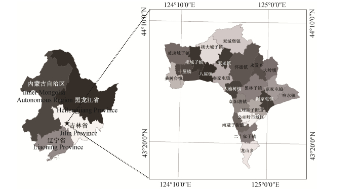
图1公主岭市位置图
Figure1.Location of Gongzhuling City in black soil zone of Northeast China
 下载: 全尺寸图片幻灯片
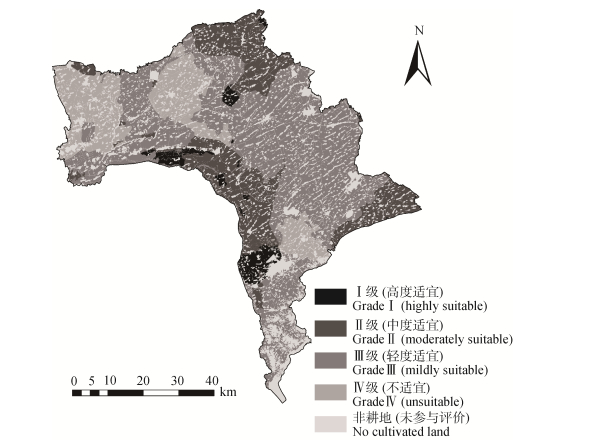
图2公主岭市耕地整治适宜性等级分布图
Figure2.Suitability grading distribution map of cultivated land consolidation in Gongzhuling City
下载: 全尺寸图片幻灯片表1公主岭市耕地整治适宜性评价离散型指标分级分值
Table1.Classification scores of discrete indexes of suitability evaluation on cultivated land consolidation in Gongzhuling City
| 指标层 Index layer | 分级 Classification | 类型 Type | 分值 Score |
| 土壤质地 Soil texture | 1 | 壤土?Loam | 1.0 |
| 2 | 黏壤土?Clay loam | 0.8 | |
| 3 | 黏土?Clay | 0.6 | |
| 4 | 砂土?Sand | 0.4 | |
| 灌溉条件 Irrigation condition | 1 | 充分满足 Complete satisfaction | 1.0 |
| 2 | 基本满足 Basic satisfaction | 0.8 | |
| 3 | 不满足?Non-satisfaction | 0.5 | |
| 排水条件 Drainage condition | 1 | 充分满足 Complete satisfaction | 1.0 |
| 2 | 基本满足 Basic satisfaction | 0.8 | |
| 3 | 不满足?Non-satisfaction | 0.5 | |
| 土壤污染程度 Soil pollution degree | 1 | 不污染?Non-polluting | 1.0 |
| 2 | 污染?Polluting | 0 |
下载: 导出CSV表2公主岭市耕地整治适宜性评价指标、权重及最适值
Table2.Evaluation index system, indexes weights and optimal niches of suitability evaluation on cultivated land consolidation in Gongzhuling City
| 准则层 Criteria layer | 指标层 Index layer | 指标类型 Index type | 权重 Weight | 最适值 Optimum niche |
| 自然条件 Natural condition | 田面坡度?Field slope (°) | 正向连续型 Positive continuous | 0.098 7 | 0° |
| 土壤质地?Soil texture | 正向离散型 Positive discrete | 0.107 0 | 壤土 Loam | |
| 有效土层厚度?Effective soil layer depth (cm) | 正向连续型 Positive continuous | 0.085 9 | 100 | |
| 土壤有机质含量?Soil organic matter content (g·kg-1) | 正向连续型 Positive continuous | 0.049 3 | 40 | |
| 耕层厚度?Topsoil thickness (cm) | 正向连续型 Positive continuous | 0.052 3 | 20 | |
| 基础设施条件 Infrastructure condition | 灌溉条件?Irrigation condition | 正向离散型?Positive discrete | 0.077 8 | 充分满足?Complete satisfaction |
| 排水条件?Drainage condition | 正向离散型?Positive discrete | 0.032 7 | 充分满足?Complete satisfaction | |
| 道路通达度?Road accessibility | 正向连续型 Positive continuous | 0.123 4 | 1 | |
| 生态可持续性 Ecological sustainability | 土壤?pH Soil pH | 适度连续型 Moderate continuous | 0.057 4 | 6~7 |
| 土壤污染程度?Soil pollution degree | 负向离散型?Negative discrete | 0.045 5 | 0 | |
| 农田防护林覆盖率?Farmland shelter belt ratio (%) | 正向连续型 Positive continuous | 0.036 1 | 3% | |
| 空间稳定性 Space stability | 距主交通干线距离 Distance from main traffic line (km) | 正向连续型 Positive continuous | 0.038 2 | 2 |
| 田块规整度 Field regularity degree | 负向连续型 Negative continuous | 0.069 4 | 1 | |
| 耕地连片度?Field contiguous degree | 正向连续型 Positive continuous | 0.126 2 | 1 |
下载: 导出CSV表3公主岭市耕地整治适宜性等级划分结果
Table3.Grading standard of suitability evaluation on cultivated land consolidation in Gongzhuling City
| 级别 Grade | 生态位适宜度值 Niche fitness value | 整治适宜性 Suitability of consolidation |
| Ⅰ | ≥0.75 | 高度适宜?Highly suitable |
| Ⅱ | 0.70~0.75 | 中度适宜?Moderately suitable |
| Ⅲ | 0.61~0.70 | 轻度适宜?Mildly suitable |
| Ⅳ | < 0.61 | 不适宜?Unsuitable |
下载: 导出CSV表4公主岭市耕地整治适宜性评价结果及障碍因素
Table4.Results and obstacle factors of suitability evaluation on cultivated land consolidation in Gongzhuling City
| 级别 Grade | 面积 Area (hm2) | 比例 Proportion (%) | 主要分布区域 Main distribution region | 主要障碍因素 Main obstacle factor | 生态位适宜度均值 Niche fitness mean value |
| Ⅰ | 13 799.89 | 4.16 | 南崴子街道、苇子沟街道、八屋镇、双龙镇东部 Nanwaizi Street, Weizigou Street, Bawu Town, east of Shuanglong Town | 农田防护林覆盖率 Farmland shelter belt ratio | 0.46 |
| 道路通达度?Road accessibility | 0.60 | ||||
| 田块规整度?Field regularity degree | 0.68 | ||||
| Ⅱ | 77 754.36 | 23.41 | 秦家屯镇、大榆树镇、朝阳坡镇、响水镇、双城堡镇 Qinjiatun Town, Dayushu Town, Chaoyangpo Town, Xiangshui Town, Shuangchengbao Town | 灌溉条件?Irrigation condition | 0.56 |
| 道路通达度?Road accessibility | 0.61 | ||||
| 农田防护林覆盖率 Farmland shelter belt ratio | 0.62 | ||||
| Ⅲ | 177 192.38 | 53.36 | 双龙镇、怀德镇、黑林子镇、永发乡、大岭镇、范家屯镇、陶家屯镇、桑树台镇、毛城子镇、二十家子镇、龙山乡 Shuanglong Town, Huaide Town, Heilinzi Town, Yongfa Town, Daling Town, Fanjiatun Town, Taojiatun Town, Sangshutai Town, Maochengzi Town, Ershijiazi Town, Longshan Town | 土壤有机质含量 Soil organic matter content | 0.48 |
| 距主交通干线距离 Distance from main traffic line | 0.52 | ||||
| 土壤?pH Soil pH | 0.57 | ||||
| Ⅳ | 63 325.61 | 19.07 | 玻璃城子镇、十屋镇、杨大城子镇、刘房子镇 Bolichengzi Town, Shiwu Town, Yangdachengzi Town, Liufangzi Town | 土壤质地?Soil texture | 0.47 |
| 灌溉条件?Irrigation condition | 0.52 | ||||
| 耕层厚度?Topsoil thickness | 0.54 |
下载: 导出CSV参考文献
| [1] | 张立江, 汪景宽, 裴久渤, 等.东北典型黑土区耕地地力评价与障碍因素诊断[J].中国农业资源与区划, 2017, 38(1): 110-117 https://www.cnki.com.cn/qikan-ZRZY201405002.html ZHANG L J, WANG J K, PEI J B, et al. Evaluation of cultivated land fertility and its obstacle factors diagnosis in the typical black soil area of Northeast China[J]. Chinese Journal of Agricultural Resources and Regional Planning, 2017, 38(1): 110-117 https://www.cnki.com.cn/qikan-ZRZY201405002.html |
| [2] | 黄文山, 周晓燕.新时期耕地保护问题探讨[J].中国土地, 2011, (2): 25-27 http://www.wanfangdata.com.cn/details/detail.do?_type=perio&id=xbnlkjdxxb-sh200301024 HUANG W S, ZHOU X Y. Discussion on cultivated land protection in the new period[J]. China Land, 2011, (2): 25-27 http://www.wanfangdata.com.cn/details/detail.do?_type=perio&id=xbnlkjdxxb-sh200301024 |
| [3] | 马春艳, 王占岐, 易平.基于ArcGIS的耕地整治潜力测算与分级研究——以湖北省房县为例[J].水土保持研究, 2015, 22(1): 207-211 http://www.doc88.com/p-9397409309914.html MA C Y, WANG Z Q, YI P. Study on the potential calculation and classification of farmland remediation based on ArcGIS — A case study on Fangxian County[J]. Research of Soil and Water Conservation, 2015, 22(1): 207-211 http://www.doc88.com/p-9397409309914.html |
| [4] | 唐秀美, 潘瑜春, 郝星耀, 等.中国耕地整治生态潜力测算方法[J].农业工程学报, 2015, 31(17): 270-277 doi: 10.11975/j.issn.1002-6819.2015.17.036 TANG X M, PAN Y C, HAO X Y, et al. Calculation method of cultivated land consolidation ecological potential in China[J]. Transactions of the CSAE, 2015, 31(17): 270-277 doi: 10.11975/j.issn.1002-6819.2015.17.036 |
| [5] | 张杰, 赵瑞东, 田超, 等.基于限制程度排序的卢龙县耕地质量提升重点区域划定研究[J].中国生态农业学报, 2017, 25(3): 429-440 http://www.ecoagri.ac.cn/zgstny/ch/reader/view_abstract.aspx?file_no=20170314&flag=1 ZHANG J, ZHAO R D, TIAN C, et al. Delineation of key areas of cultivated land quality improvement in Lulong County based on restriction degree[J]. Chinese Journal of Eco-Agriculture, 2017, 25(3): 429-440 http://www.ecoagri.ac.cn/zgstny/ch/reader/view_abstract.aspx?file_no=20170314&flag=1 |
| [6] | 李冰清, 王占岐, 金贵.新农村建设背景下的土地整治项目绩效评价[J].中国土地科学, 2015, 29(3): 68-74 https://mall.cnki.net/lunwen-1013345035.html LI B Q, WANG Z Q, JIN G. Performance evaluation of land consolidation project in the context of the new countryside development[J]. China Land Sciences, 2015, 29(3): 68-74 https://mall.cnki.net/lunwen-1013345035.html |
| [7] | 杜鑫昱, 夏建国, 章大容.四川省土地整理项目绩效评价[J].中国生态农业学报, 2015, 23(4): 514-524 http://www.ecoagri.ac.cn/zgstny/ch/reader/view_abstract.aspx?file_no=2015416&flag=1 DU X Y, XIA J G, ZHANG D R. Evaluation of performance of land consolidation projects in Sichuan Province[J]. Chinese Journal of Eco-Agriculture, 2015, 23(4): 514-524 http://www.ecoagri.ac.cn/zgstny/ch/reader/view_abstract.aspx?file_no=2015416&flag=1 |
| [8] | 胡学东, 王占岐, 邹利林.基于贝叶斯概率模型的鄂西北山地区耕地整治适宜性评价[J].资源科学, 2016, 38(1): 83-92 http://mall.cnki.net/magazine/magadetail/ZRZY201601.htm HU X D, WANG Z Q, ZOU L L. Suitability evaluation of arable land consolidation in mountain areas of Northwestern Hubei based on Bayesian Probability Modeling[J]. Resources Science, 2016, 38(1): 83-92 http://mall.cnki.net/magazine/magadetail/ZRZY201601.htm |
| [9] | 张跃星, 周建.基于GIS的土地整治适宜性评价——以岑巩县为例[J].贵州师范大学学报:自然科学版, 2014, 32(5): 28-31 http://d.wanfangdata.com.cn/Periodical_njhyj201001003.aspx ZHANG Y X, ZHOU J. A evaluation of land consolidation suitability based on GIS — A case study of Cengong County[J]. Journal of Guizhou Normal University: Natural Sciences, 2014, 32(5): 28-31 http://d.wanfangdata.com.cn/Periodical_njhyj201001003.aspx |
| [10] | 崔勇, 刘志伟.基于GIS的北京市怀柔区高标准基本农田建设适宜性评价研究[J].中国土地科学, 2014, 28(9): 76-81 http://www.docin.com/p-1378921188.html CUI Y, LIU Z W. A GIS-based approach for suitability evaluation of high standard primary farmland consolidation: A case from Huairou in Beijing[J]. China Land Sciences, 2014, 28(9): 76-81 http://www.docin.com/p-1378921188.html |
| [11] | HUTCHINSON G E. Concluding remarks[J]. Cold Spring Harbor Symposia on Quantitative Biology, 1957, 22: 415-427 doi: 10.1101/SQB.1957.022.01.039 |
| [12] | 李自珍, 赵松岭, 张鹏云.生态位适宜度理论及其在作物生长系统中的应用[J].兰州大学学报:自然科学版, 1993, 29(4): 219-224 http://www.oalib.com/references/16420958 LI Z Z, ZHAO S L, ZHANG P Y. The niche-fitness theory and its application to the systems of crop growth[J]. Journal of Lanzhou University: Natural Sciences, 1993, 29(4): 219-224 http://www.oalib.com/references/16420958 |
| [13] | 曾庆敏, 刘新平.天山北坡经济带宜耕未利用地开发潜力分区及评价——以新疆阜康市为例[J].中国生态农业学报, 2016, 24(6): 819-828 http://www.ecoagri.ac.cn/zgstny/ch/reader/view_abstract.aspx?file_no=2016614&flag=1 ZENG Q M, LIU X P. Evaluation of potential of unused land exploitation in Northern Tianshan Mountain Economic Belt — A case study of Fukang City[J]. Chinese Journal of Eco-Agriculture, 2016, 24(6): 819-828 http://www.ecoagri.ac.cn/zgstny/ch/reader/view_abstract.aspx?file_no=2016614&flag=1 |
| [14] | 念沛豪, 蔡玉梅, 谢秀珍, 等.基于生态位理论的湖南省国土空间综合功能分区[J].资源科学, 2014, 36(9): 1958-1968 http://industry.wanfangdata.com.cn/dl/Detail/Periodical?id=Periodical_zykx201409023 NIAN P H, CAI Y M, XIE X Z, et al. Geographical space comprehensive function zoning in Hunan Province based on niche theory[J]. Resources Science, 2014, 36(9): 1958-1968 http://industry.wanfangdata.com.cn/dl/Detail/Periodical?id=Periodical_zykx201409023 |
| [15] | 张俊峰, 张安录.土地资源空间异质性与经济发展水平的关系研究——以武汉城市圈为例[J].自然资源学报, 2015, 30(5): 725-735 doi: 10.11849/zrzyxb.2015.05.002 ZHANG J F, ZHANG A L. Study on relationship between spatial heterogeneity of land resources and economic development: A case study of Wuhan Urban agglomeration[J]. Journal of Natural Resources, 2015, 30(5): 725-735 doi: 10.11849/zrzyxb.2015.05.002 |
| [16] | 秦天天, 齐伟, 李云强, 等.基于生态位的山地农村居民点适宜度评价[J].生态学报, 2012, 32(16): 5175-5183 http://d.wanfangdata.com.cn/Periodical_nygcxb201011050.aspx QIN T T, QI W, LI Y Q, et al. Suitability evaluation of rural residential land based on niche theory in mountainous area[J]. Acta Ecologica Sinica, 2012, 32(16): 5175-5183 http://d.wanfangdata.com.cn/Periodical_nygcxb201011050.aspx |
| [17] | 赵素霞, 牛海鹏, 张捍卫, 等.基于生态位模型的高标准基本农田建设适宜性评价[J].农业工程学报, 2016, 32(12): 220-228 doi: 10.11975/j.issn.1002-6819.2016.12.032 ZHAO S X, NIU H P, ZHANG H W, et al. Suitability evaluation on high quality capital farmland consolidation based on niche-fitness model[J]. Transactions of the CSAE, 2016, 32(12): 220-228 doi: 10.11975/j.issn.1002-6819.2016.12.032 |
| [18] | OUYANG Z Y, JASON W, WANG R S. Ecological niche suitability model with an application in Taojiang land use planning[J]. Journal of Environmental Science, 1994, 6(4): 449-456 http://www.cqvip.com/QK/85265X/199404/3001317037.html |
| [19] | 王慧敏. 闽北耕地整理前后的质量变化研究——以建瓯市为例[D]. 福州: 福建农林大学, 2014 http://www.wanfangdata.com.cn/details/detail.do?_type=degree&id=D583575 WANG H M. Research on the quality variation before and after cultivated land consolidation in northern Fujian — A case study of Jian'ou City[D]. Fuzhou: Fujian Agriculture and Forestry University, 2014 http://www.wanfangdata.com.cn/details/detail.do?_type=degree&id=D583575 |
| [20] | 张正峰, 陈百明, 郭战胜.耕地整理潜力评价指标体系研究[J].中国土地科学, 2004, 18(5): 37-43 http://d.wanfangdata.com.cn/Periodical_gtzykjgl200806015.aspx ZHANG Z F, CHEN B M, GUO Z S. Indicator system for evaluating arable land consolidation potential[J]. China Land Science, 2004, 18(5): 37-43 http://d.wanfangdata.com.cn/Periodical_gtzykjgl200806015.aspx |
| [21] | 郭姿含, 杨永侠.基于GIS的耕地连片性分析方法与系统实现[J].地理与地理信息科学, 2010, 26(3): 59-62 http://industry.wanfangdata.com.cn/dl/Detail/Periodical?id=Periodical_dlxygtyj201003014 GUO Z H, YANG Y X. GIS-based farmland connectivity analysis methods research and system implementation[J]. Geography and Geo-Information Science, 2010, 26(3): 59-62 http://industry.wanfangdata.com.cn/dl/Detail/Periodical?id=Periodical_dlxygtyj201003014 |
| [22] | 钱凤魁. 基于耕地质量及其立地条件评价体系的基本农田划定研究——以辽宁省凌源市为例[D]. 沈阳: 沈阳农业大学, 2011 http://cdmd.cnki.com.cn/Article/CDMD-10157-1012302288.htm QIAN F K. Study on the planning of basic farmland based on the evaluation system of farmland quality and site conditions — A case study of Lingyuan City in Liaoning Province[D]. Shenyang: Shenyang Agricultural University, 2011 http://cdmd.cnki.com.cn/Article/CDMD-10157-1012302288.htm |
| [23] | 于婧, 聂艳, 周勇, 等.生态位适宜度方法在基于GIS的耕地多宜性评价中的应用[J].土壤学报, 2006, 43(2): 190-196 doi: 10.11766/trxb200501050203 YU J, NIE Y, ZHOU Y, et al. Niche-fitness theory and its application to GIS-based multi-suitability evaluation of cultivated land[J]. Acta Pedologica Sinica, 2006, 43(2): 190-196 doi: 10.11766/trxb200501050203 |
| [24] | 杨志恒.基于Ward法的区域空间聚类分析[J].中国人口·资源与环境, 2010, 20(3): 382-386 http://www.docin.com/p-739178251.html YANG Z H. Region spatial cluster algorithm based on Ward method[J]. China Population, Resources and Environment, 2010, 20(3): 382-386 http://www.docin.com/p-739178251.html |
