HTML
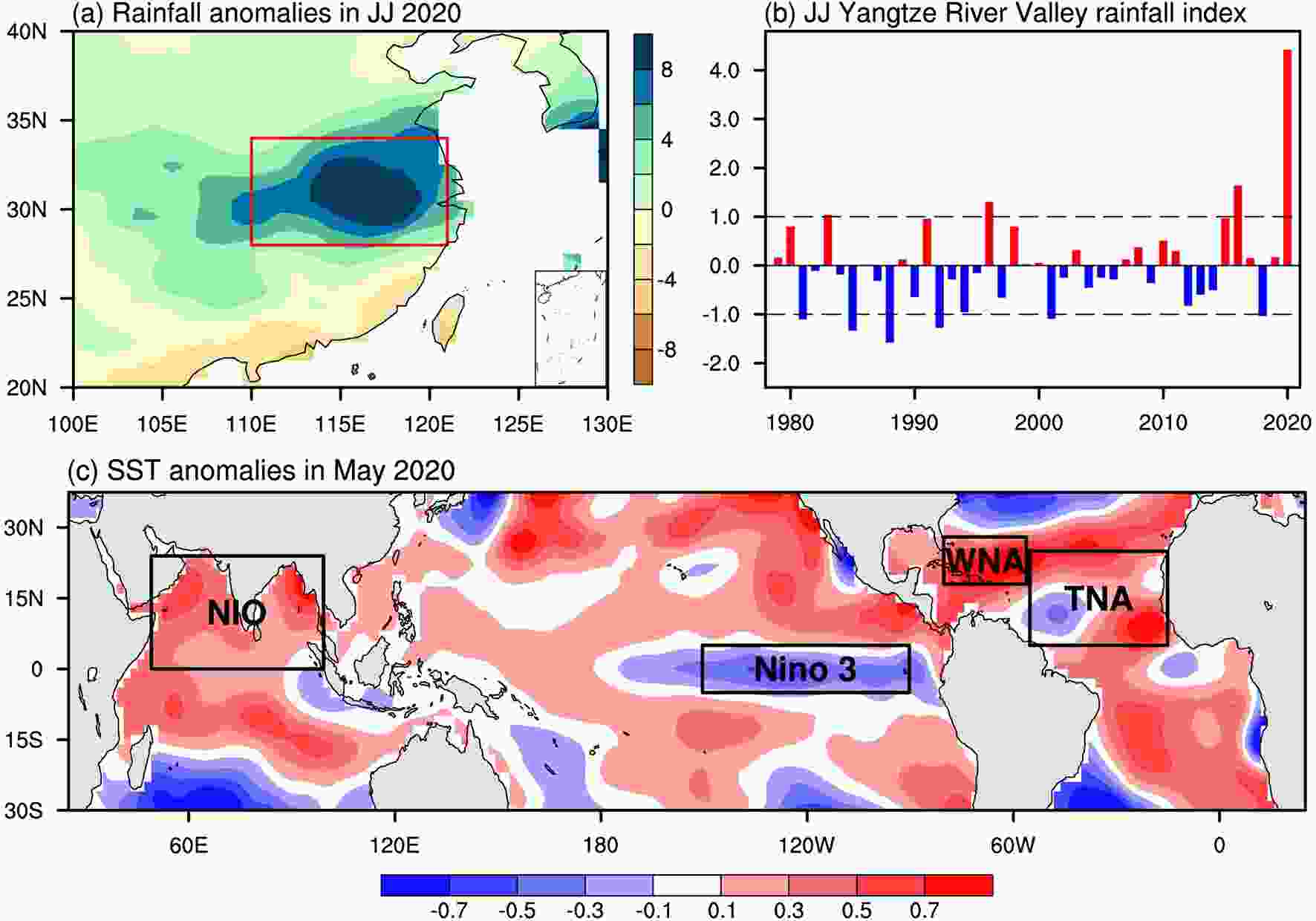
--> --> --> Figure1. Rainfall and SST anomalies in June–July (JJ) 2020. (a) Rainfall anomalies (mm d–1) over China in JJ 2020. (b) Standardized time series of the JJ rainfall index in the YRV region. (c) SST anomalies (°C) in May 2020. The red box in (a) represents the YRV region (110°–122°E, 30°–34°N). NIO, TNA, and WNA stand for the Northern Indian Ocean (50°–100°E, 0°–24°N), Tropical North Atlantic (55°–15°W, 5°N–25°N), and Western North Atlantic (80°–56°W, 18°–28°N), respectively. The Ni?o-3 box is in the equatorial eastern Pacific (150°–90°W, 5°S–5°N). The rainfall data are from NOAA’s Precipitation Reconstruction over Land dataset and SSTs are NOAA’s ERSST version 5.
Since it takes time for the atmosphere to respond to oceanic changes, we examine the distribution of sea surface temperature (SST) anomalies in May 2020 over the global oceans (Fig. 1c). The tropical Pacific shows La Ni?a conditions with cold SST anomalies in the equatorial eastern Pacific, which evolved from a weak central Pacific type of El Ni?o in the preceding winter of 2019/20. The warm conditions in the Northern Indian Ocean (NIO) in May 2020 are developed from the super Indian Ocean dipole in 2019 (Takaya et al., 2020; Zhou et al., 2021). As is the usual case after an El Ni?o event in the preceding winter, the tropical North Atlantic also displays warm SST anomalies in the following spring. Following Enfield et al. (1999), the tropical North Atlantic (TNA) is defined as the region of 55°–15°W, 5°–25°N. To investigate the roles of these oceanic variations in the YRV rainfall, we calculate regressions of JJ rainfall anomalies onto the NIO SST anomalies (50°–100°E, 0°–24°N), the Ni?o-3 index, and the TNA SST anomalies (Figs. 2a–c). The NIO SST is correlated with the YRV rainfall, whereas ENSO is related to rainfall in southern China. Figure 2c shows that the TNA SST is not significantly correlated with the rainfall in the YRV region; however, this is not the whole story.
 Figure2. Relationships of June–July (JJ) rainfall anomalies with SST anomalies. (a) Regression of JJ rainfall anomalies onto NIO May SST anomalies. (b) Regression of JJ rainfall anomalies onto the May Ni?o-3 index, (c) Regression of JJ rainfall anomalies onto the TNA May SST anomalies, (d) Regression of JJ rainfall anomalies onto WNA May SST anomalies. The areas of rainfall anomalies significant at the 95% confidence level are dotted.
In studying the YRV rainfall in June 2020, Zheng and Wang (2021) found that the positive SST anomalies in May over the tropical western North Atlantic (WNA; 80°–56°W, 18°–28°N) induce positive geopotential height anomalies in June over the midlatitude North Atlantic, which affect the rainfall anomalies in the YRV via an Atlantic-induced atmospheric “wave train” across Eurasia. Here, we also calculate the regression of JJ rainfall anomalies onto the May WNA SST anomalies (Fig. 2d). The May WNA SST anomalies are significantly correlated with the JJ YRV rainfall. This suggests that in addition to conditions in the NIO, conditions in the WNA are also important for JJ heavy rainfall in the YRV of China.
To fully understand each ocean’s influences on the summer rainfall in the YRV, separate analyses of June and July rainfall anomalies are necessary. As shown in Zheng and Wang (2021), the significant regression of June rainfall anomalies onto the NIO May SST anomalies is mainly outside of the YRV region. The modeling results of Takaya et al. (2020) also show that the rainfall influence of the Indian Ocean SST anomalies is outside of the YRV region. It seems that the June rainfall anomalies in the YRV cannot be explained by the NIO May SST anomalies. However, both the June and JJ rainfall anomalies in the YRV are significantly related to the May SST in the WNA. In summary, the Indian Ocean does not relate to the June rainfall over the YRV, but the WNA does. If we consider the June and July rainfall together, both the Indian Ocean and WNA are important.
Another consideration is the relationship of the 2020 summer floods in China with global warming. Almost all climate models indicate that “wet gets wetter, dry gets drier” based on studies and assessments of historical and future climate change, but the models often do not agree over land (Held and Soden, 2006). We use rainfall observations to calculate the rainfall trend over China. Our calculation shows an increased rainfall trend during the past 70 years in most areas of China (figure not shown), which is consistent with the results presented in the Blue Book on Climate Change in China (CMA Climate Change Centre, 2020). Although it is hard to attribute an individual extreme rainfall event to global warming, many efforts of “event attribution” have been made (e.g., Trenberth et al., 2015; Diffenbaugh et al., 2017).
 Figure3. Typhoon activity and large-scale environmental factors in 2020. (a) The number of tropical cyclones (TCs) in 2020 and climatological mean TCs. (b) The distribution of vertical wind shear anomalies (m s–1) in June 2020. (c) The 600-hPa relative humidity anomalies (%) in June 2020. The vertical wind shear is calculated as the magnitude of the vector difference between winds at 200 hPa and 850 hPa. The TC data are from the JTWC (Joint Typhoon Warning Center) and other data are from the ERA5 dataset.
A natural question is: What is the relationship between global warming and TCs? Observational and numerical modeling studies have reached a consensus regarding the influences of global warming on global TC activity. First, global warming will reduce the number of global TCs because global warming increases the stability of the atmosphere, which is not conducive to the development of atmospheric convection. Second, global warming will increase the intensity of TCs and rainfall since global warming strengthens thermodynamical factors that favor rainfall and intensification of TCs. Third, global warming makes TCs move northward or northeastward, which is not favorable for TCs to landfall in the southeast coast. This is because the warming of the oceans will weaken the subtropical high, thereby changing the TCs’ steering flow and driving TCs northward or northeastward. In spite of these consensus results, it is hard to attribute 2020 typhoon activity in the WNP to global warming.
 Figure4. The distributions of air temperatures at 2 meters and sea level pressure in China. (a) Average temperature anomalies (°C) during the winter of 1 December 2020 to 20 February 2021. (b) Temperature anomalies (°C) during the cold surge of 6–8 January 2021. (c) SLP anomalies (hPa) during the cold surge of 6–8 January 2021. The data are from the ERA5 reanalysis product.
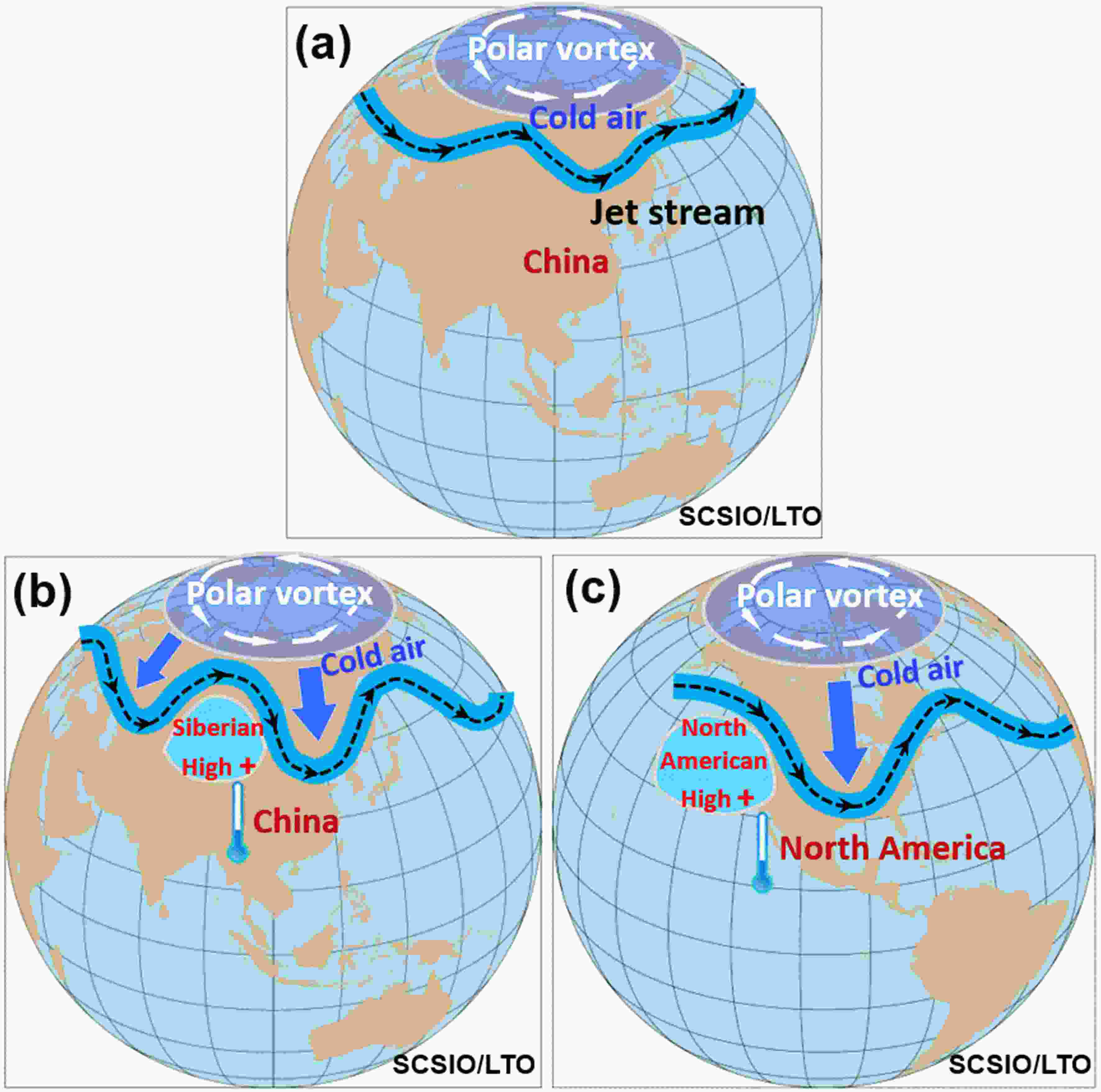
Sunlight distribution causes the tropics to be warm and the Arctic to be cold, with strong north-south temperature gradients. Associated with the temperature gradients are the strong westerly winds in the middle?high latitudes which are called the jet stream. In a normal winter, the jet stream is relatively flat, which acts as a lasso of sorts and keeps the cold polar air trapped inside the Arctic (Fig. 5a). A change of the atmosphere can make the flat jet stream become a wavy jet stream (Fig. 5b). Figure 4c shows the distribution of sea level pressure (SLP) anomalies for the cold surge event during 6–8 January 2021. Large positive SLP anomalies are located in the western region of Russia, causing the Siberian High to intensify and move northward. The intensification and northward movement of the Siberian High perturbs the jet stream to be wavy and redirects it in the northwest-southeast direction, allowing the cold polar air to plunge south and resulting in the cold surge event.
 Figure5. Schematic diagrams of atmospheric circulation patterns associated with winter cold surges. (a) A normal mild winter with the relatively flat jet stream. (b) A cold surge in China with the enhanced Siberian High and wavy jet stream. (c) A cold surge in the United States with the enhanced North American High and wavy jet stream. The wavy jet stream allows cold polar air to plunge south, thus resulting in a cold surge event.
Regarding global warming, the wavy jet stream theory still works (e.g., Francis et al., 2015; Ding et al., 2008). The increase of air temperature under global warming is not uniform over the world. The fastest warming rate is occurring in the Arctic, and this phenomenon is called Arctic Amplification (Cohen et al., 2014) in association with the Arctic sea ice decrease. The fast Arctic warming reduces the north-south temperature contrast which affects the strength of the jet stream. The reduced temperature contrast results in a weaker and wavier jet stream, which is more likely to spill the cold polar air southward. Thus, global warming increases the occurrence of extreme cold surge events.
There are other views or hypotheses on the relationship between cold surge events and Arctic sea ice loss. Different from the wavy jet stream theory, Kug et al. (2015) and Mori et al. (2019) suggest that the influences of sea ice loss on cold winters can be operated through a teleconnection pattern. Other studies have proposed that Arctic sea ice loss weakens the stratospheric polar vortex, which induces a negative phase of the Arctic Oscillation at the surface, resulting in low temperatures in midlatitudes (e.g., Kim et al., 2014; Nakamura et al., 2015; Peings and Magnusdottir, 2014). Many other studies found no influences of Arctic sea ice loss on the midlatitudes of Eurasia (Li et al., 2015; McCusker et al., 2016; Ogawa et al., 2018).
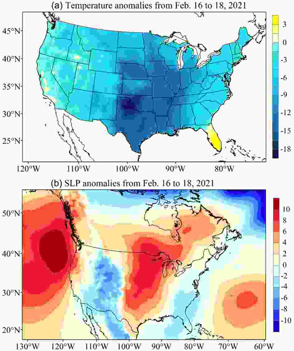
Recently, an extreme cold surge event plunged south across the central United States and was one of the coldest events on record for many states in the United States (Fig. 6a). During the cold surge of 16–18 February 2021, temperature anomalies over the entire United States were negative except for parts of the Florida Peninsula and California. The lowest values were centered over Texas reaching a minimum of ?18°C. As shown in Figs. 5c and 6, the mechanisms of the cold surge in the United States are similar to the cold surge event that occurred in China. During 16–18 February 2021, large positive SLP anomalies were located to the west of North America, which were probably caused by the northward extension of the subtropical high. Over North America, the North American High (Reed, 1933) is analogous to the Siberian High in Eurasia. Intensification and movement of the North American High facilitate the wavy jet stream and allow cold polar air to invade southward.
 Figure6. The distributions of air temperatures at 2 meters and sea level pressure (SLP) in the United States. (a) Temperature anomalies (°C) during the cold surge of 16–18 February 2021. (b) SLP anomalies (hPa) during the cold surge of 16–18 February 2021. The data are from the ERA5 reanalysis product.
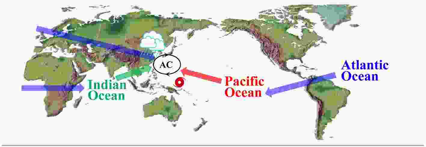
 Figure7. Schematic diagram showing the influences of three oceans on the western North Pacific (WNP), climate in China, and typhoon activity. AC stands for the anomalous anticyclone in the WNP. All three oceans affect AC in the WNP. The Pacific Ocean’s impact on AC is via processes associated with ENSO events, whereas the Indian Ocean’s impact is through Kelvin wave processes. The influences of the Atlantic Ocean on AC have three routes: (1) westward via Rossby wave response; (2) eastward via Kelvin wave response; and (3) eastward across Europe via atmospheric “wave-train”.
In section 4, we did not discuss the roles of the oceans in the winter cold surges in China or the United States. However, the oceans do affect winter temperatures over land. In particular, it is well known that ENSO events can influence winter temperatures across the globe (e.g., Halpert and Ropelewski, 1992). It is also worthy of mentioning that the tropical Pacific was experiencing a La Ni?a event during the 2020/21 winter. La Ni?a events tend to intensify the North American High, which can certainly facilitate cold polar air to intrude southward (Figs. 5 and 6).
In summary, 2020 was an unusual year with summer floods and winter cold surges occurring in China and quiet typhoon activity during the first half of the typhoon season in the WNP. The SSTs in the Pacific, Indian, and Atlantic Oceans all made contributions to heavy rainfall in China, but the Atlantic and Indian Oceans seem to have played dominant roles. The intensification and movement of the Siberian High made the jet stream take on a wavier pattern that allowed the cold polar air to invade southward, and thus induce the cold surges in China. The western North Pacific experienced large vertical wind shear and low humidity during the first half of the typhoon season, both of which are not favorable for the formation and development of typhoons. Global warming can increase the occurrence of extreme weather and climate events; however, the contribution of global warming to an individual extreme weather and climate event is challenging to quantify. The cold surge during 16–18 February 2021 in the United States shares similar mechanisms with the recent cold surges in China.
Acknowledgements. This study is supported by the National Natural Science Foundation of China (Grant No. 41731173), the National Key R&D Program of China (Grant No. 2019YFA0606701), the Strategic Priority Research Program of the Chinese Academy of Sciences (Grant Nos. XDB42000000 and XDA20060502), the Key Special Project for Introduced Talents Team of Southern Marine Science and Engineering Guangdong Laboratory (Guangzhou) (Grant No. GML2019ZD0306), the Innovation Academy of South China Sea Ecology and Environmental Engineering, the Chinese Academy of Sciences (Grant No. ISEE2018PY06), and the Leading Talents of Guangdong Province Program.
