 ,1, 汪德根,2
Spatial differentiation and influencing mechanism of nearby urbanization in central and western China
ZHAO Meifeng,1, WANG Degen,2通讯作者:
收稿日期:2020-08-3修回日期:2021-07-3
| 基金资助: |
Received:2020-08-3Revised:2021-07-3
| Fund supported: |
作者简介 About authors
赵美风(1986-), 女, 河北鹿泉人, 博士, 副教授, 主要从事城市地理与人口地理研究。E-mail:

摘要
关键词:
Abstract
Keywords:
PDF (3171KB)元数据多维度评价相关文章导出EndNote|Ris|Bibtex收藏本文
本文引用格式
赵美风, 汪德根. 中国中西部地区就近城镇化空间分异格局及机理. 地理学报, 2021, 76(12): 2993-3011 doi:10.11821/dlxb202112009
ZHAO Meifeng, WANG Degen.
1 引言
1978年改革开放以来,中国经历了世界上最大规模的城镇化过程,城镇化率从1978年的17.92%上升至2015年的56.1%,深刻改变了中国的经济社会格局。但中国城镇化呈现出明显的非均衡发展特征[1],2015年东部地区常住人口城镇化率高达64.54%,已形成了京津冀、长三角和珠三角等3大国家级城市群,成为全国重要的经济增长极;与此相比,中部和西部地区分别仅为51.72%和48.27%,城镇化水平相对滞后,严重制约了地区社会经济发展。新时代背景下,紧抓西部大开发和中部崛起战略深入推进、东部沿海地区产业转移加快等发展机遇,根据经济发展水平、资源环境本底和城镇化发展阶段,加快推进中西部地区新型城镇化进程,是促进中西部地区社会经济快速发展、推进中国区域协调发展的重要举措[2]。当前,中国城镇化进入由“数量增长”向“质量提升”、由从“土地城镇化”向“人的城镇化”的转型发展阶段。《国家新型城镇化规划(2014—2020年)》明确提出了“三个1亿人”的目标,其中一个“1亿”是针对中西部地区,即引导约1亿人在中西部地区就近城镇化。中国中西部地区资源环境承载能力相对较低,经济基础薄弱,导致大量农村剩余劳动力向东部沿海经济发达地区流动,形成中国特色的异地城镇化路径模式。因受远距离乡城迁移人口自身社会经济条件限制,以及区域间户籍制度及其教育、医疗、养老和就业等社会福利制度障碍,传统的异地城镇化模式引致中西部地区产生一系列经济社会问题,既表现在农村进城人口难以平等享受当地城镇基本公共服务、农业转移人口市民化进程受阻等城市层面,又表现在农村社会主体过快老弱化、乡村工业化和农业现代化进程缓慢、农村土地资源浪费等乡村层面[3,4,5]。因此,新型城镇化背景下,就近城镇化成为中西部地区破除异地城镇化模式弊端、保障农业和乡村可持续发展、推进城镇化健康发展的现实路径选择[6,7,8]。
全面推进乡村振兴和建成小康社会背景下,就近城镇化对促进中西部地区城乡经济社会发展具有重大意义。中西部地区是中国贫困人口和深度贫困群体的主要分布区,14个集中连片特困地区均位于中西部。2020年中国将实现现行标准下农村贫困人口全部脱贫的目标,但是相对贫困问题仍将长期存在[9,10]。就近城镇化进程有利于促进区域经济增长、拓宽非农就业渠道、提高农民收入,从而缓解农村贫困。研究表明2000—2014年中国城镇化发展显著降低了西部农村、非平原农村和纯农村地区的贫困发生率,城镇化水平每提高1%,家庭人均收入增长约0.7%,家庭人均消费增长约1.1%[11,12]。
就近城镇化是相对于异地城镇化而言的城镇化发展模式,目前关于其概念和内涵并没有达成统一的共识,“就地城镇化”“就近城镇化”“本地城镇化”“县域城镇化”“就近就地城镇化”等多个含义相近的概念术语被政界和学界广泛使用[13,14]。李强认为就近城镇化是指“农村人口不是远距离迁徙,而是近距离迁移到家乡附近的市镇,主要界定为以地级市和县级城镇为核心的城镇化”[13]。朱宇等发现东南沿海一些村和人口没有通过大规模空间转移而实现向城镇或准城镇类型转化,提出“就地城镇化”的概念[15]。杨传开将就地城镇化界定为农业转移人口在同一个县域范围内,向县城、乡镇、农村社区、就地转型的村庄等具有城镇功能形态地区就地转移,实现城镇化的过程[16]。国外没有“就近城镇化”的专业术语,但关于大都市区、都市带的提法均反映了就近城镇化的内涵[17,18]。综合****们的研究成果,本文认为就近城镇化是指农村人口不是远距离迁移,而是近距离迁移到户籍所在地附近的中小城市和小城镇就业和居住,实现农民职业非农化、生活城市化和身份市民化的过程。
国内就近城镇化的相关研究可追溯到20世纪80年代初自下而上的乡村城镇化[19]、90年代末的县域城镇化[20]以及21世纪初东南沿海发达地区农村聚落就地转换为城镇型社会的“就地城镇化”现象[15]。随着国家新型城镇化战略的提出,就近城镇化研究成为学术界关注的热点,在就近城镇化理论内涵、微观机制、发展路径等方面的研究取得了大量成果。同时,重点开展了山东、河南、四川等区域就近城镇化模式的典型案例研究[21,22,23]。就近城镇化是宏观层面乡村地区自身社会经济发展与微观层面乡村人口迁移空间选择的结果[19, 21, 24-26]。就近城镇化发展路径应以资源环境承载力为基础,以地级市和县域为核心,以培育壮大地级市、县级市和中心镇等多级空间载体为目标,充分发挥地级市和县城的人口经济集约化优势和城镇聚集效应,因地制宜、分区分类制定,强化政府的规划引导作用和回流农民工的主体作用,发展以县域经济、强镇崛起和以地级市为单位的3种就近城镇化模式[4-5, 13, 16, 23, 28-29]。2015年以来中国流动人口总量逐步减少,农民工向中西部地区回流的态势日益增强,成为就近城镇化发展的新动力[27],呈现出多种就近城镇化模式,如河南的“既不离土也不离乡”农村城镇化道路,重庆的“复垦+流转”农村闲置宅基地处置模式,四川巴中和云南昆明的全域城镇化模式[5]。
目前关于就近城镇化研究,研究视角主要以社会学和公共管理学等角度所进行的理论探讨,研究尺度主要以微观层面所进行的典型区域就近城镇化动力机制的实践探索。但中国中西部地区地域辽阔、发展差异大,各地区资源环境本底、经济水平和城市化阶段存在较大差异,必须因地制宜、因地施策推进中西部地区就近城镇化进程,实现这一目标应以地理学为视角,从大尺度宏观层面揭示中西部就近城镇化地域分异规律及其影响机理。基于此,本文以中国中西部地区211个地级行政区为研究对象,构建就近城镇化率、就近城镇化贡献力和就近城镇化贡献势等指标,测度2000—2015年中西部地区就近城镇化水平及其来源地构成的空间分异及演变特征;在此基础上运用空间计量模型,构建就近城镇化贡献力模型和贡献势模型,深入剖析中西部地区就近城镇化贡献力和贡献势的主导因子及驱动机制,揭示中西部地区就近城镇化空间分异的影响机理。本文从宏观层面厘清中国中西部地区就近城镇化空间格局特征及演变规律,为新型城镇化背景下中西部地区科学确定就近城镇化的主流人群对象和主导空间载体,因地制宜制定就近城镇化发展战略提供理论基础和科学依据。
2 研究设计
2.1 就近城镇化率相关测度指标
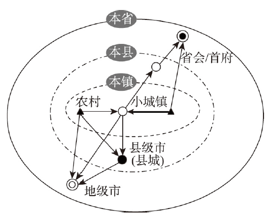
就近城镇化的概念内涵包含3个核心信息:① 主体是农业转移人口;② 空间载体是户籍所在地附近的中小城市和小城镇;③ 迁移范围是近距离[8, 14, 22]。由于就近城镇化是相对于异地城镇化的发展模式,其空间载体和尺度范围具有较大弹性,如何界定“户籍所在地附近”的空间尺度在学术界并没有达成统一共识,提出了省域中心城市、地级市、县级市、县城、中心镇等多种基于行政单元地域范围的空间尺度[5-6, 13-14, 22]。这种界定方法充分考虑到了中国行政单元范围内地理环境特征和社会经济文化的统一性,同时有利于与中国现有社会经济统计数据以行政单元为基本统计单元相衔接。中国中西部地区整体城镇化水平较低,相当一部分地级市和县城的人口集聚能力极低、跨省人口流出规模占比极大[30]。因此,为了全面展示中西部地区就近城镇化的空间格局,本文将就近城镇化的空间范围界定为“本省”,即以本省范围内的省会或首府城市、地级市、县级城镇和小城镇为核心,农业转移人口迁移到户籍登记地所在省份的城镇就业和居住的城镇化过程。考虑到省域是一个很大的空间尺度,省域内部拥有省会或首府城市、地级市、县级城镇和小城镇等多种类型就近城镇化载体,本文在最大化就近城镇化空间尺度基础上,依据农业转移人口的迁移尺度,进一步将就近城镇化细分为本镇城镇化、本县城镇化和本省城镇化3个类型(图1)。其中,本镇城镇化指农业转移人口迁移到本乡、镇、街道的城镇地区就业和居住,空间载体以小城镇为主;本县城镇化指农业迁移人口迁移到本县其他乡、镇、街道的城镇地区就业和居住,空间载体以县级市市区或县城为主;本省城镇化指农业转移人口迁移到本省其他县的城镇地区就业和居住,空间载体以省会/首府城市市区、地级市市区为主。图1
 新窗口打开|下载原图ZIP|生成PPT
图1就近城镇化示意图
Fig. 1Diagram of nearby urbanization
(1)就近城镇化率。依据本文界定的就近城镇化空间范围,就近城镇化人口的统计口径为“居住在本乡镇街道,户口在本省范围乡镇街道的城镇人口”。就近城镇化率即就近城镇化人口与常住总人口的比值,计算公式如下:
式中:NU代表就近城镇化率;Pnu代表就近城镇人口;P代表常住总人口。
(2)就近城镇化贡献力。依据户口属性,就近城镇化人口由本省户籍城镇人口、本县户籍城镇人口和本镇户籍城镇人口(以下分别简称本省城镇人口、本县城镇人口和本镇城镇人口)3类人口构成,其中,本省城镇人口是指居住本乡镇街道,户口在本省其他县(市、区)的城镇人口;本县城镇人口是指居住本乡镇街道,户口在本县(市、区)其他乡镇街道的城镇人口;本镇城镇人口是指居住本乡镇街道,户口在本乡镇街道的城镇人口。贡献力(也称贡献度)指标是人口地理学经常使用的指标,主要测度某一类型人口增长对城镇化发展的贡献程度,即贡献能力。参考已有研究[31,32,33],本文构建就近城镇化贡献力指标,用以表征各层级空间单元户籍城镇人口在就近城镇总人口中所占的比重。贡献力越大,代表该层级空间单元人口迁移对就近城镇化的贡献力度越大。本文构建本省贡献力、本县贡献力和本镇贡献力3个指标,用以测度就近城镇化的来源地构成,计算公式如下:
式中:CNUp、CNUc、CNUt分别代表本省贡献力、本县贡献力和本镇贡献力;Pnup、Pnuc、Pnut分别代表本省城镇人口、本县城镇人口和本镇城镇人口;Pnu代表就近城镇总人口。
(3)就近城镇化贡献势。为进一步分析某一时期就近城镇化贡献率的动态变化和发展趋势,本文构建了就近城镇化贡献势指标,用以表征一定时期内各层级空间单元户籍城镇人口在就近城镇总人口中所占比重的变化趋势,即贡献趋势,简称贡献势。贡献势是正值,代表该层级空间单元人口迁移对就近城镇化的贡献力呈上升趋势,贡献势越大,上升趋势越快;贡献势是负值,代表该层级就近城镇化贡献力呈下降趋势,贡献势越小,下降趋势越快。本文构建本省贡献势、本县贡献势和本镇贡献势3个指标,用以测度就近城镇化来源地构成的发展趋势。
就近城镇化最大贡献势即为本省贡献势、本县贡献势和本镇贡献势三者的最大值,其对应的空间单元即为就近城镇化的优势空间单元。计算公式如下:
式中:TNUp、TNUc、TNUt分别代表本省贡献势、本县贡献势和本镇贡献势;TNU代表就近城镇化最大贡献势;t、0分别表示末期和基期。
2.2 就近城镇化空间分异模型
考虑到就近城镇化及其影响因素的潜在空间自相关性,本文分别以就近城镇化贡献力和就近城镇化贡献势为因变量,构建空间计量模型识别就近城镇化空间分异的关键影响因子及其影响程度。其中,就近城镇化贡献力模型采用空间面板杜宾模型,就近城镇化贡献势模型采用空间横截面杜宾模型。2.2.1 就近城镇化贡献力空间面板模型 已有研究认为就近城镇化发展水平和来源地结构主要受到自然环境条件[36]、经济发展水平[37]、城镇公共服务资源[38,39]、交通运输条件[40,41]和地方行政力量[42,43,44,45,46]等因素的多重影响。据此,本文选取自然环境状况、经济发展水平、城镇公共服务资源、交通运输条件和地方行政力量等5个要素层面共12个变量作为解释变量。其中,自然环境要素包括海拔高度(DEM)、坡度(SL)2个变量;经济发展要素包括人均国内生产总值(PGDP)、固定资产投资(FAI)、地方财政收入(FIN)、城镇居民可支配收入(INC)、工业化水平(IND)和服务业水平(SEV)6个变量,工业化水平利用工业产值占GDP比重表示,服务业水平利用第三产业产值占GDP比重表示;城镇公共服务资源要素包括中小学校生师比(EDU)和每万人卫生机构床位数(MED)2个变量;交通运输要素利用公路密度(TRA)来代表;地方行政维度要素利用城市行政等级(GOV)来代表,分为省会/首府城市(PC)和一般地级行政区(C)两类。为了降低空间计量模型的异方差,本文对海拔高度(DEM)、坡度(SL)、人均国内生产总值(PGDP)、固定资产投资(FAI)、地方财政收入(FIN)、城镇居民可支配收入(INC)和公路网密度(TRA)等变量进行了对数转换。
由于就近城镇化贡献力空间面板模型选用的个别控制变量(如区域的高程、坡度、城市行政等级等非时变量)是不随时间变化的,又因个体固定效应(空间固定)要对所有变量进行组内离差平减处理,无法一致性估计非时变量的影响系数[34,35],因此,本文选用时间固定效应的空间面板模型。空间面板杜宾模型是空间误差和空间滞后模型的一般形式,本文仅列出空间面板杜宾模型的计算公式,具体为:
式中:CNU表示就近城镇化贡献力;W表示解释变量和被解释变量的空间权重矩阵;γt、μit分别表示时间效应和误差项;ρ、θ分别是被解释变量和解释变量的空间滞后项系数;α0、α、ρ、θ是待估计参数。
2.2.2 就近城镇化贡献势空间横截面杜宾模型 由于就近城镇化贡献势只有空间维度,无时间维度,即横截面数据,因此本文选用空间横截面杜宾模型构建就近城镇化贡献势空间计量模型。因变量是2000—2015年中西部地区各地级行政区就近城镇化贡献势;自变量包括自然环境状况、经济发展水平、城镇公共服务资源、交通运输条件和地方行政力量等5个要素层面共12个变量。其中自然环境要素包括海拔高度(DEM)、坡度(SL)2个变量;经济发展要素包括人均国内生产总值变化(ΔPGDP)、固定资产投资变化(ΔFAI)、地方财政收入变化(ΔFIN)、城镇居民可支配收入变化(ΔINC)、工业化水平变化(ΔIND)和服务业水平变化(ΔSEV)6个变量,工业化水平变化利用工业产值占GDP比重的变化来表示,服务业水平利用第三产业产值占GDP比重的变化表示;城镇公共服务资源要素包括中小学校生师比变化(ΔEDU)和每万人卫生机构床位数变化(ΔMED)2个变量;交通运输要素利用公路密度变化(ΔTRA)来代表;地方行政维度要素利用城市行政等级(GOV)来代表,分为省会/首府城市(PC)和一般地级行政区(C)两类。
与就近城镇化贡献力模型相同,就近城镇化贡献势模型中也对海拔高度(DEM)、坡度(SL)、人均国内生产总值变化(ΔPGDP)、固定资产投资变化(ΔFAI)、地方财政收入变化(ΔFIN)、城镇居民可支配收入变化(ΔINC)和公路网密度变化(ΔTRA)等变量进行了对数转换。由于空间横截面杜宾模型是空间误差和空间滞后模型的一般形式,本文仅列出空间横截面杜宾模型的计算公式,具体为:
式中:TNU表示就近城镇化贡献势;W表示解释变量和被解释变量的空间权重矩阵;ε是误差项;ζ、η分别是被解释变量和解释变量的空间滞后项系数;β0、β、ζ、η是待估计参数。
2.3 数据来源与说明
本文的中国中西部地区包括中部地区的晋、豫、皖、赣、鄂、湘和西部地区的桂、渝、川、贵、云、藏、蒙、陕、甘、青、宁、新等共18个省份、211个地级行政区。人口数据来自各省2000年和2010年人口普查资料,以及2015年1%人口抽样调查资料。关于2015年就近城镇化相关数据,有3点说明:① 就近城镇人口总量是基于各省人口抽样比例进行的推算结果;② 由于2015年1%人口抽样调查缺少城镇外来人口户籍登记地的数据项,依据外来总人口户籍登记地在“本省其他县”和“本县”的分布比例,推算城镇外来人口户籍登记地相应分布比例;此外,利用2000年和2010年人口普查资料进行核算验证,上述两个比例具有很高一致性;③ 由于安徽、内蒙古和西藏等3个省份未公开发布地级数据,只发布省级数据,本文分析2015年就近城镇化空间格局时,这3个省份各地级行政区采用全省平均值替代。社会经济统计数据主要来自《中国区域经济统计年鉴》《中国城市统计年鉴》、各省份统计年鉴等。地理信息基础数据来源于地球系统科学数据共享平台和地理空间数据云。鉴于2011年安徽省地级巢湖市已撤销,为统一口径,本文选择除巢湖市之外的211个地级行政区进行分析。3 中西部地区就近城镇化空间分异特征
2000年、2010年和2015年中国中西部地区就近城镇人口总数分别为1.96亿人、2.91亿人和3.47亿人,就近城镇化率分别为28.16%、40.53%和46.89%,其中,2000—2010年期间年均提高了1.24个百分点,而2010—2015年期间年均提高了1.27个百分点。3.1 就近城镇化贡献力分布格局及演变特征
2000—2015年中国中西部地区就近城镇化的主要来源是本镇户籍人口,即本镇贡献力>本省贡献力>本县贡献力。但本镇贡献力呈持续下降趋势,由2000年的81.05%下降到2015年的73.57%;本县贡献力呈波动上升趋势,由2000年的4.92%快速提高到2010年的14.12%,转而小幅下降到2015年的11.49%;本省贡献力变化不大,持续稳定在12%~15%之间。3.1.1 本镇贡献力分布格局及演变特征 依据等间距法,将本镇贡献力划分为低等级(< 60%)、中低等级(60%~70%)、中等级(70%~80%)、中高等级(80%~90%)、高等级(≥ 90%)等5个级别。2000年,本镇贡献力以中高等级为主,广泛分布在中西部大部分地区,其他4个等级呈“零星状”分布,其中,高等级零星分布在西藏南部、新疆北部、甘肃南部、陕西南部、云南西北部和广西东部等区域;中等级在中西部大部分地区零星分布,中低等级主要分布在内蒙古中部,以及成都、贵阳、南宁、拉萨等省会城市,低等级仅分布在昆明市(图2a1)。
图2
 新窗口打开|下载原图ZIP|生成PPT
图22000—2015年中国中西部地区本镇、本县和本省的贡献力空间分布
注:基于自然资源部标准底图服务网站GS(2019)1827号标准地图制作,底图边界无修改。
Fig. 2Spatial distribution of CNUt, CNUc, CNUp in central and western China in 2000-2015
与2000年相比,2010年本镇贡献力呈现出“两减三增”变化,即高等级和中高等级数量明显减少,低等级、中低等级、中等级数量明显增加;从分布来看,高等级仅集中分布在西藏南部,中高等级在西藏西部和新疆西部呈“团块状”分布,在河南、安徽、江西、湖南、广西、云南、四川、甘肃和陕西等省份部分区域,形成“圈层状”分布特点;中等级广泛分布在中西部大部分省份;低等级和中低等级主要在内蒙古中部、青海中东部和四川西部呈“团块状”分布,并在广西和江西呈“零星状”分布(图2a2)。
与2010年相比,2015年本镇贡献力呈现出“三减两增”变化,即高等级和中低等级的数量增加,而中高等级、中等级和低等级的数量减少;从分布来看,高等级主要在四川呈“簇状”分布特征,并零星分布在新疆、云南、河南等部分区域;中高等级进一步缩小分布范围,主要分布在中西部沿陇海线呈“带状”分布,以及在湖北、湖南、江西、广西、新疆等省份呈“簇状”零星分布;中等级主要集中分布在西藏呈“团块状”分布,在安徽、江西、贵州、湖北和重庆等省份呈“带状”分布;中低等级主要在内蒙古、新疆和青海等省份呈“团块状”分布;低等级零星分布在甘肃和新疆等区域(图2a3)。
3.1.2 本县贡献力分布格局及演变特征 本县贡献力可划分为低等级(< 5%)、中低等级(5%~10%)、中等级(10%~15%)、中高等级(15%~20%)、高等级(≥ 20%)等5个级别。2000年,本县贡献力以中低等级为主,广泛分布在中西部大部分地区,其他4个等级呈“零星式”分布,其中,高等级和中高等级主要分布在内蒙古中部、新疆西部、湖南和四川等零星城市;中等级主要在甘肃北部、内蒙古、新疆北部呈“团块状”分布,在安徽、江西、湖北、四川和云南等省份呈“零星式”分布;低等级在西藏南部、陕西南部、青海、河南和广西等地区呈“簇状”分布(图2b1)。
与2000年相比,2010年本县贡献力呈现出“两增三减”变化,即高等级和中高等级数量明显增加,低等级、中低等级、中等级数量明显减少;从分布来看,高等级主要在内蒙古、陕西北部、山西北部、青海等地区呈“带状”分布;中高等级主要在重庆、四川、贵州、广西等地区呈“连片状”分布,在湖北、江西等省份呈“簇状”分布;中等级主要在新疆、甘肃南部、四川西部、云南、安徽等省份呈“团块状”分布;中低等级主要在云南、广西等西南地区和青海、新疆、陕西等西北地区呈“零星式”分布;低等级集中分布在西藏(图2b2)。
与2010年相比,2015年本县贡献力呈现出“两减三增”变化,即高等级和中高等级数量明显减少,低等级、中低等级、中等级数量明显增加,这与2000—2010年的变化趋势正好相反;从分布来看,高等级主要在山西、陕西、甘肃、青海和新疆等地区呈“零星式”分布;中高等级主要集中分布在内蒙古,也零星分布在江西、湖南、贵州、云南和广西等省份;中等级主要在湖北、湖南、贵州、广西、云南、甘肃和新疆等省份呈“簇状”分散分布;中低等级主要在中西部沿陇海线呈“带状”分布,在湖南、广西和云南等省份呈“簇状”分散分布;低等级集中分布在西藏和四川(图2b3)。
3.1.3 本省贡献力分布格局及演变特征 本省贡献力可划分为低等级(< 5%)、中低等级(5%~10%)、中等级(10%~20%)、中高等级(20%~30%)、高等级(≥ 30%)等5个级别。2000年,本省贡献力以中等级和中低等级为主,广泛分布在中西部大部分省份,其他3个等级呈分散分布,其中,高等级仅零星分布在南宁、柳州、昆明、呼和浩特和包头等城市;中高等级主要在中西部的省会城市和海西、鄂尔多斯等典型牧区呈“零星式”分布;低等级主要在云南、贵州、广西和湖北等省份呈“零星式”分布,在甘肃、新疆和西藏等省份呈“团块状”分布(图2c1)。
与2000年相比,2010年本省贡献力各等级的地级行政区数量并未显著变化,但空间分布有较大变化,其中,高等级仅零星分布在南宁、贵阳、成都和呼和浩特等城市;中高等级主要在省会城市和内蒙古、四川等省份的资源型城市和工业型城市呈“零星式”分布;中等级主要在云南、广西、贵州、四川、重庆、西藏、内蒙古、甘肃和陕西等省份呈“簇状”分布;中低等级和低等级在中西部大部分地区呈“交融连片状”分布(图2c2)。
与2010年相比,2015年本省贡献力呈现出“两增三减”变化,即高等级和中高等级的数量增加,而中等级、中低等级和低等级的数量减少;从分布来看,高等级主要分布在中西部地区的省会城市;中高等级主要分布在内蒙古以及零星分布在甘肃、陕西、新疆和青海等省份;中等级主要在西藏和新疆呈“团块状”分布,在安徽、四川、重庆、广西、贵州、云南、湖南、江西、湖北和河南等省份呈“簇状”分布;中低等级和低等级仍呈“连片状”分布在中西部大部分地区(图2c3)。
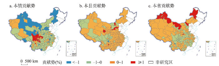
3.2 就近城镇化贡献势分布格局特征
2000—2015年期间,中国中西部地区就近城镇化的本县贡献势最大,为0.44%,即本县户籍城镇人口在就近城镇总人口中所占的比重年均增长0.44%,本县范围内人口流动对就近城镇化贡献力的上升趋势最快;本省贡献势居第二,为0.06%;最小的是本镇贡献势,为-0.5%,即本镇户籍城镇人口所占比重年均降低0.5%。综上,2000—2015年中国中西部地区就近城镇化的优势空间单元是本县范围内,即县域尺度。为进一步分析就近城镇化贡献势的空间分布特征,将就近城镇化贡献势分为低等级(< -1%)、中低等级(-1%~0)、中高等级(0~1%)和高等级(≥ 1%)等4个级别。
(1)2000—2015年期间,中西部地区就近城镇化的本镇贡献势呈中低等级和低等级“连片覆盖”、中高等级和高等级“零星分布”的格局。其中,低等级连片分布在山西北部、陕西北部、内蒙古东部和西部、青海南部、新疆等地区;中低等级连片分布在中西部大部分地区;中高等级在新疆和西藏等地区呈“团块状”分布,在河南、湖南和四川等省份呈“簇状”分布;高等级集中分布在四川(图3a)。
图3
 新窗口打开|下载原图ZIP|生成PPT
图32000—2015年中国中西部地区本镇、本县和本省的贡献势空间分布
注:基于自然资源部标准底图服务网站GS(2019)1827号标准地图制作,底图边界无修改。
Fig. 3Spatial distribution of TNUt, TNUc, TNUp in central and western China in 2000-2015
(2)与本镇贡献势相反,本县贡献势呈中高等级“集中连片”、中低等级“团块散布”、高等级和低等级“零星点缀”的分布格局。其中,中高等级集中连片分布在中西部大部分地区;中低等级主要在四川、内蒙古中部和西藏中东部呈“团块状”分布;高等级零星分布在六盘水、新余、榆林、乌海、石嘴山和包头等资源型城市;低等级仅分布在宜宾市(图3b)。
(3)本省贡献势呈现中高等级“西部连片覆盖、中部簇状”、中低等级“团块交融”、高等级和低等级“零星点缀”分布格局。其中,中高等级在西藏、新疆、青海等西部地区呈“连片状”分布,在云贵黔和两湖地区呈“簇状”分布;中低等级主要在河南、江西、四川、湖北和湖南等省份呈“团块状”分布;高等级零散分布在新疆北部和内蒙古等地区;低等级仅分布在攀枝花市(图3c)。西藏和新疆大部分地区本省贡献势较高的主要原因为:① 这些地区城镇化水平较低,城镇体系呈现“下宽上窄无腰”的畸形金字塔结构,即首位城市充分发展、中等城市缺乏、小城市大量存在[47,48];② 新疆以重工业为主导的工业化进程和西藏以定向援助、城镇化政策为主导的城镇化过程,导致这些地区具有较强的外县人口吸引力,而本地农村剩余劳动力隐性化现象突出[49,50,51]。
4 中西部地区就近城镇化空间分异的影响机理
为全面分析中西部地区就近城镇化空间分异的驱动机制,本文建立了就近城镇化贡献力空间面板模型和就近城镇化贡献势空间横截面模型,深入剖析中西部地区就近城镇化空间分异的核心驱动因子。本文综合使用Moran's I和LM两种检验方法,判断中西部地区就近城镇化贡献力空间分异模型是否选择空间计量模型。① 全局Moran's I计算结果显示,中西部地区就近城镇化贡献力的空间自相关系数均处于0.4~0.7(p < 0.01)之间,说明存在显著的空间自相关性,可以尝试构建空间计量模型。② 通过构建就近城镇化贡献力的常用空间面板数据模型(空间滞后面板模型、空间误差面板模型和空间杜宾面板模型),发现本镇贡献力和本县贡献力的空间效应显著,适合选用空间计量模型;而本省贡献力的空间效应不显著,适合选用一般面板数据模型。③ 进一步利用LM检验,确定本镇贡献力和本县贡献力的最优空间计量模型均为空间杜宾面板模型。
本文综合使用Moran's I和LR两种检验方法,判断中西部地区就近城镇化贡献势空间分异模型是否选择空间计量模型。① 被解释变量TNUt、TNUc和TNUp的全局Moran's I值分别为0.496、0.467和0.434(p < 0.01),由此得知,就近城镇化贡献势存在着显著的空间依赖性。因此,OLS基于变量间相互独立且不相关的假设不成立,需要采用空间计量模型进一步分析。② 对于截面数据的空间计量模型选择,采用对数似然比检验(LR)。通过比较受约束与不受约束模型对数似然函数值的差,即-2×(LogL受约束-LogL不受约束),若超过服从卡方分布的临界值,则不施加约束模型(空间杜宾模型)优于施加约束模型(空间滞后模型和空间误差模型)。3个模型中空间杜宾模型与空间滞后模型、空间杜宾模型与空间误差模型的LR检验统计值均分别远高于临界值3.84和5.99,3个模型中空间杜宾模型解释效果均好于空间滞后模型和空间误差模型,因此,本文选取空间杜宾模型的回归结果来解释就近城镇化贡献势的影响因素。
4.1 就近城镇化贡献力主导因子
表1为空间面板数据模型结果,同时列出普通面板数据模型数据结果用以对比分析。结果表明,两个模型中各影响因素对就近城镇化贡献力的作用方向基本一致,但作用程度略有差异。由于本省贡献力空间计量模型的空间效应不显著,本省贡献力空间分异模型选择普通面板数据模型。Tab. 1
表1
表1中国中西部地区就近城镇化贡献力空间面板杜宾模型计算结果
Tab. 1
| 模型 | 普通面板数据模型 | 空间面板数据模型 | ||||||||||
|---|---|---|---|---|---|---|---|---|---|---|---|---|
| 因变量 | CNUt | CNUc | CNUp | CNUt | CNUc | CNUp | ||||||
| 系数 | 标准误 | 系数 | 标准误 | 系数 | 标准误 | 系数 | 标准误 | 系数 | 标准误 | 系数 | 标准误 | |
| lnDEM | -2.076*** | 0.453 | 0.949*** | 0.300 | 1.128*** | 0.350 | -2.094*** | 0.579 | 1.063*** | 0.405 | 1.030** | 0.413 |
| lnSL | 0.429 | 0.578 | -0.234 | 0.370 | -0.195 | 0.405 | 0.566 | 0.762 | -0.492 | 0.518 | -0.104 | 0.512 |
| lnPGDP | -10.543*** | 1.348 | 2.524*** | 0.884 | 8.019*** | 0.908 | -10.572*** | 1.270 | 2.061** | 0.933 | 8.433*** | 0.965 |
| lnFAI | -0.141 | 0.922 | 0.085 | 0.594 | 0.056 | 0.645 | -0.249 | 0.863 | 0.100 | 0.545 | 0.162 | 0.632 |
| lnFIN | -0.744 | 0.979 | -0.141 | 0.671 | 0.885 | 0.572 | -0.149 | 1.041 | -0.326 | 0.681 | 0.489 | 0.595 |
| lnINC | 0.639 | 1.069 | -0.575 | 0.644 | -0.064 | 0.853 | 0.786 | 1.099 | -0.693 | 0.707 | -0.054 | 0.822 |
| IND | 0.190* | 0.057 | -0.117*** | 0.035 | -0.073* | 0.039 | 0.183*** | 0.056 | -0.102*** | 0.038 | -0.078** | 0.040 |
| SEV | -0.146* | 0.060 | -0.072* | 0.039 | 0.217*** | 0.040 | -0.165** | 0.064 | -0.061 | 0.043 | 0.228*** | 0.039 |
| EDU | -0.179 | 0.118 | -0.007 | 0.079 | 0.186** | 0.076 | -0.200 | 0.121 | -0.009 | 0.084 | -0.199 | 0.076 |
| MED | 0.103* | 0.050 | -0.104*** | 0.030 | 0.000 | 0.031 | 0.115** | 0.046 | -0.111*** | 0.029 | -0.005 | 0.030 |
| lnTRA | 0.440 | 0.432 | 0.076 | 0.264 | -0.516 | 0.366 | 0.448 | 0.437 | 0.164 | 0.296 | -0.600 | 0.374 |
| GOV | -7.638*** | 1.739 | -1.443* | 0.813 | 9.081*** | 1.591 | -6.826*** | 1.663 | -1.815 | 1.894 | 8.939*** | 1.722 |
| W×DEM | -0.687 | 0.889 | 0.737 | 0.665 | -0.024 | 0.721 | ||||||
| W×SL | 2.547** | 1.201 | -1.007 | 0.816 | -1.462 | 1.236 | ||||||
| W×PGDP | -3.287 | 2.148 | 6.203*** | 1.536 | -2.236 | 1.554 | ||||||
| W×FAI | 2.480* | 1.461 | -1.477 | 1.008 | -1.011 | 1.043 | ||||||
| W×FIN | -1.169 | 1.305 | 0.343 | 0.923 | 0.902 | 1.023 | ||||||
| W×INC | -0.083 | 2.036 | -0.811 | 1.540 | 1.137 | 1.535 | ||||||
| W×IND | -0.063 | 0.093 | -0.023 | 0.064 | 0.090 | 0.070 | ||||||
| W×SEV | -0.008 | 0.100 | -0.022 | 0.062 | 0.058 | 0.072 | ||||||
| W×EDU | -0.063 | 0.203 | 0.335** | 0.138 | -0.291** | 0.133 | ||||||
| W×MED | 0.139* | 0.072 | -0.076* | 0.043 | -0.070 | 0.043 | ||||||
| W×TRA | -1.453* | 0.875 | 0.993 | 0.603 | 0.356 | 0.619 | ||||||
| W×GOV | -0.997 | 6.215 | -5.126 | 4.062 | 7.848* | 4.705 | ||||||
| ρ | 0.101* | 0.053 | 0.123** | 0.055 | -0.012 | 0.049 | ||||||
| R2 | 0.419 | 0.423 | 0.524 | |||||||||
| Loglikelihood | -1785.983 | -1546.444 | -1607.727 | |||||||||
| AIC | 3635 | 3178 | 3264 | 3624 | 3144 | 3268 | ||||||
| BIC | 3699 | 3243 | 3320 | 3735 | 3256 | 3379 | ||||||
| N | 531 | 531 | 531 | 531 | 531 | 531 | ||||||
新窗口打开|下载CSV
本镇贡献力空间面板数据模型结果显示,海拔高度、人均GDP、工业化水平、服务业水平、每万人卫生机构床位数和地方行政等级等因素对本镇贡献力具有显著影响。其中,海拔高度、人均GDP、服务业水平和地方行政等级越高,本镇贡献力越低;工业化水平和每万人卫生机构床位数越高,本镇贡献力越高。这表明本镇贡献力受到自然环境、经济发展、公共服务供给和行政力量等多方面因素的综合影响。其中,自然环境状况、工业化水平和基本公共服务供给对本镇贡献力产生正向促进效应;而经济发展水平、服务业水平和地方行政等级对本镇贡献力产生负向抑制效应。自然环境因素对本镇贡献力具有显著的促进作用,主要原因在于中西部自然条件优越地区往往是人口密度大、农村剩余劳动力多的传统农区,为本地工业化和城镇化发展提供了充裕的人口基础,导致就近城镇化的本镇贡献力数值较大。并且较高的人口基数也导致中西部自然条件优越地区成为全国主要的人口流出区,为区域外部人口提供的就业机会较少。同时,由于中西部地区优质公共服务设施普遍较为缺乏,同时存在严重的城乡差距,流动人口对城镇基本公共服务的诉求尤为重要[39],优质的基础教育资源和医疗资源对本地农业转移人口产生重要的吸引力。本县贡献力空间面板数据模型结果显示,海拔高度和人均GDP对本县贡献力具有显著的正向影响,而工业化水平和每万人卫生机构床位数对本县贡献力具有显著的负向影响。这表明,本县贡献力主要受到自然环境、经济发展和基本公共服务供给等因素的影响。其中,经济发展对本县贡献力具有正向促进作用,经济发展水平越高、本县贡献力越高;自然环境、工业化水平和基本公共服务对本县贡献力具有负向抑制作用,工业化水平越高、基本公共服务供给越充足,本县贡献力越低。较高的经济发展水平可以极大增强区域对非农产业人口的吸纳能力,进而提高区域对周边乡镇农业转移人口的吸引能力。由于本县贡献力与本镇贡献力处于此消彼长的关系,导致自然环境、工业化水平和基本公共服务对本县贡献力的作用方向与本镇贡献力截然相反。本省贡献力面板数据模型结果显示,海拔高度、人均GDP、工业化水平、服务业水平、普通中小学生师比和地方行政等级等因素对本省贡献力影响显著。其中,海拔高度、人均GDP、服务业水平和地方行政等级越高,本省贡献力越高;工业化水平越高,本省贡献力越低。这表明,本省贡献力受到自然环境、经济发展、公共服务供给和行政力量等多方面因素的综合影响。但上述因素对本省贡献力与本镇贡献力的作用方向截然相反。自然环境状况、工业化水平和基本公共服务供给对本省贡献力产生负向抑制效应;而经济发展水平、服务业水平和地方行政等级对本省贡献力产生正向促进效应。相较于工业各部门,服务业产生的非农就业机会更多、职工工资收入更高,因此区域较高的服务业水平成为本省其他市劳动力迁移的重要动力。对于中西部欠发达地区来说,政府在资源配置中占据核心主导地位,省会城市往往拥有更多的公共资源配置和政策优惠[33],进而对更大范围的本省农业转移人口产生强劲的拉力。
4.2 就近城镇化贡献势主导因子
本镇贡献势空间杜宾模型回归结果显示,中小学生师比对本镇贡献势具有显著的正向促进效应,控制其他变量不变的情况下,中小学生师比增幅每提高1%,本镇贡献势将降低0.018(表2)。海拔高度、服务业水平变化量和地方行政等级等因子对本镇贡献势具有显著的负向影响。这表明与本镇贡献力相同,自然环境状况和基本公共服务供给改善仍对本镇贡献势产生正向促进效应,服务业水平变化和地方行政力量仍对本镇贡献势产生负向抑制效应。但是,工业化水平变化对本镇贡献势的影响程度变得微弱,主要原因在于随着工业化水平的不断提高,工业各门类对非农就业人口的吸纳能力呈衰减态势。与此相反,良好优越的自然环境条件和不断完善的城镇基础服务设施将会对本地劳动力转移的吸引力和承载力呈持续上升态势。Tab. 2
表2
表2中国中西部地区就近城镇化贡献势空间横截面杜宾回归模型计算结果
Tab. 2
| 自变量 | TNUt | TNUc | TNUp | |||
|---|---|---|---|---|---|---|
| 系数 | T值 | 系数 | T值 | 系数 | T值 | |
| lnDEM | -0.414*** | -2.636 | 0.206** | 2.287 | 0.203* | 1.835 |
| lnSL | 0.259 | 0.828 | -0.152 | -0.868 | -0.102 | -0.021 |
| ΔlnPGDP | -0.158 | -1.280 | 0.155** | 2.185 | 0.010 | 0.117 |
| ΔlnFAI | 0.108 | 0.798 | -0.141 | -0.819 | 0.033 | 0.348 |
| ΔlnFIN | 0.009 | 0.076 | 0.006 | 0.083 | -0.017 | -0.194 |
| ΔlnINC | -0.073 | -0.222 | -0.204 | -1.078 | 0.277 | 1.194 |
| ΔIND | -0.008 | -1.496 | 0.002 | 0.583 | 0.007 | 0.650 |
| ΔSEV | -0.012** | -2.084 | 0.002 | 0.553 | 0.010** | 2.554 |
| ΔEDU | 0.018* | 1.873 | -0.008 | -1.377 | -0.011 | -1.547 |
| ΔMED | 0.000 | 0.093 | 0.000 | 0.004 | -0.001 | -0.311 |
| ΔlnTRA | -0.077 | -1.346 | 0.060* | 1.833 | 0.018 | 0.431 |
| GOV | -0.560** | -2.575 | 0.257** | 2.057 | 0.306** | 1.991 |
| W×lnDEM | 0.533*** | 2.976 | -0.270*** | -2.624 | -0.257** | -2.036 |
| W×lnSL | -0.499*** | -2.948 | 0.237** | 2.438 | 0.264** | 2.209 |
| W×ΔlnPGDP | -0.429* | -1.650 | 0.032 | 0.214 | 0.441** | 2.417 |
| W×ΔlnFAI | -0.166 | -0.603 | 0.166 | 1.051 | 0.007 | 0.035 |
| W×ΔlnFIN | 0.148 | 0.688 | -0.057 | -0.460 | -0.101 | -0.664 |
| W×ΔlnINC | 0.159 | 0.337 | -0.085 | -0.311 | -0.069 | -0.206 |
| W×ΔIND | 0.029** | 2.502 | -0.016** | -2.373 | -0.014* | -1.688 |
| W×ΔSEV | 0.001 | 0.091 | -0.004 | -0.507 | 0.004 | 0.402 |
| W×ΔEDU | -0.015 | -0.982 | 0.017* | 1.892 | -0.002 | -0.147 |
| W×ΔMED | 0.022*** | 3.633 | -0.009*** | -2.670 | -0.013*** | -3.056 |
| W×ΔlnTRA | -0.060 | -0.534 | -0.052 | -0.811 | 0.120 | 1.521 |
| W×GOV | -0.154 | -0.368 | 0.036 | 0.148 | 0.110 | 0.372 |
| ρ | 0.444*** | 5.405 | 0.442*** | 5.288 | 0.384*** | 4.381 |
| R2 | 0.533 | 0.498 | 0.451 | |||
| Loglikelihood | -133.855 | -35.823 | -71.160 | |||
| N | 177 | 177 | 177 | |||
新窗口打开|下载CSV
本县贡献势空间杜宾模型回归结果显示,海拔高度、人均GDP增长速度、公路网密度增加和地方行政等级对本县贡献势具有显著正向促进效应(表2)。控制其他变量不变的情况下,人均GDP增加量每提高1%,本县贡献势将提高0.155;公路网密度每增加1%,本县贡献势将提高0.06;相对于一般地级行政区,省会城市或首府的本县竞争势将增加0.257。这表明与本县贡献力相同,自然环境状况和经济发展速度仍对本县贡献势产生正向促进效应。此外,交通基础设施和地方行政力量对本县内部劳动力迁移的影响程度不断增强。中西部地区中小城市交通可达性普遍偏低,成为制约其经济发展的重要瓶颈。近年来,随着中西部地区交通运输条件的不断改善,极大促进了中小城市产业发展和城镇建设,对本地及周边乡镇劳动力的吸引能力也日益增强。
本省贡献势空间杜宾模型回归结果显示,海拔高度、服务业水平变化量和地方行政力量对本省贡献势具有显著正向促进影响(表2)。控制其他变量不变的情况下,服务业水平增加量每增加1%,本省贡献势将提高0.01;相对于一般地级行政区,省会城市或首府的本省竞争势将增加0.306。与本省贡献力相同,服务业水平增长速度和地方行政力量对本省贡献势产生正向促进作用,但是,经济发展速度和地方财政收入增加的影响程度变得极其微弱。持续提高的服务业发展水平将产生更多的非农劳动力就业机会和更高的工资收入水平,从而增强区域对本省范围内劳动力的吸引能力。中国中西部地区整体发展水平较低,仍处于点状开发过程,地方行政中心和行政等级较高的城市在资源配置中所起的核心主导作用将长期存在,间接影响区域社会经济发展水平和人口集聚能力。
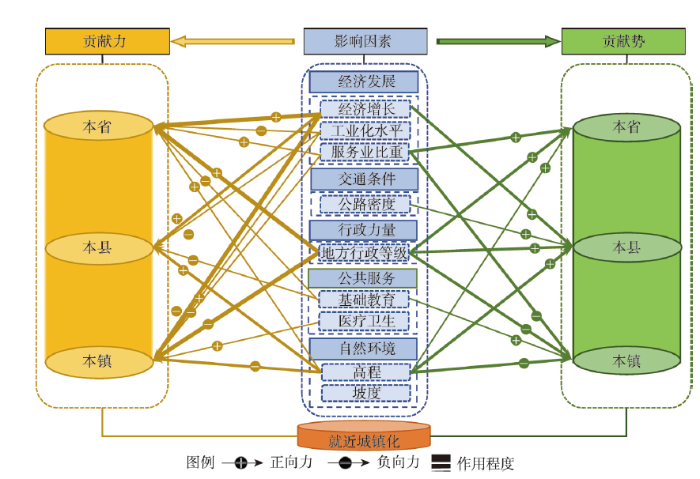
4.3 就近城镇化空间分异的影响机理
根据就近城镇化贡献力和贡献势回归模型的结果,中西部地区就近城镇化空间分异是自然环境因素、经济发展因素、城镇公共服务供给、交通运输条件和地方行政力量等多重要素综合作用的结果(图4)。下面具体分析各影响因素对就近城镇化的作用机制。图4
 新窗口打开|下载原图ZIP|生成PPT
图4中国中西部地区就近城镇化空间分异的影响机理
Fig. 4Influencing mechanism of the spatial differentiation of nearby urbanization in central and western China
(1)良好的自然条件是中小城镇承接本地农村劳动力转移的基本要素。自然环境背景对城镇化发展具有重要的基础支撑作用,奠定了城镇化空间分异的基本格局[36]。作为城镇化的类型之一,就近城镇化同样受到自然环境因子的基础性影响。优越的自然条件为农业发展和城镇发展提供了天然的自然优势,显著影响就近城镇人口的来源地构成。模型结果显示,自然环境越优越的地区,本镇贡献力和贡献势越高,而本县贡献力和贡献势以及本省贡献力和贡献势越低。这表明当区域自然环境优越时,中西部地区乡村人口更愿意选择转移到本地城镇而非远距离城镇,本地城镇居民也更倾向长期居留而非迁移他地。从模型结果看,相对于其他社会经济因素,自然环境对就近城镇化的影响相对较小。
(2)经济发展水平主导本省和本县内部劳动力转移的方向,工业化水平是承接本镇农村劳动力转移的关键要素,服务业水平是承接本省劳动力转移的关键要素。区域经济增长和非农产业发展是城镇化的核心驱动力,显著影响着中西部地区就近城镇的来源地构成,且对来源地构成的发展趋势起着核心主导作用。区域经济增长显著提高中西部地区就近城镇化的本县贡献力和本省贡献力,从而降低本镇贡献力。工业化水平和服务业水平对就近城镇化来源地构成的作用方式截然不同:工业化水平显著提高本镇贡献力,从而降低本县和本省贡献力;而服务业水平显著提高本省贡献力,从而降低本镇贡献力。这说明工业化初期,中西部地区就近城镇化主要来源于本镇农村劳动力转移;到工业化中后期,随着服务业水平的提高,本省其他市和本县其他镇劳动力迁移成为就近城镇化的新动力。同时,区域经济增长显著增强中西部地区就近城镇化的本县贡献势,服务业水平显著增强就近城镇化的本省贡献势。表明对于中西部大中城市来说,快速增长的区域经济和持续较高的服务业发展水平是增强其承接本省内部和本县内部农村劳动力转移的关键因素。中西部地区资源型城市凭借丰富的煤炭、石油等矿产能源,资源与能源开采产业及其相关工业发展迅猛,人均GDP普遍高于其他城市,如鄂尔多斯和克拉玛依;而省会城市作为全省政治、文化和经济中心,服务业水平占比较高,如武汉和长沙。由此,较高的人均GDP或服务业水平导致上述两类区域对较远距离的本省和本县劳动力的吸引能力远远高于其他区域,成为就近城镇化本省贡献力和本县贡献力的高值区。
(3)充裕的公共服务资源是增强小城镇承接本地劳动力转移能力的重要途径。根据人口迁移的“推—拉”理论,除较高的工资收入和较多的就业机会外,迁入地较好的生活水平和较完善的教育、医疗和文化等公共服务设施也是吸引人口迁入的主要动力[37]。一些研究发现随着城镇化水平的不断提高,中国流动人口的利益诉求不再局限于经济利益,社会利益尤其是城镇基本公共服务成为流动人口的新诉求[38],尤其对于中西部人口流出地区,优质公共服务成为就近城镇化主要动力[39]。模型结果显示基础教育资源和医疗资源供给越充裕的区域,就近城镇化的本镇贡献力和贡献势越高,而本县贡献力越低。也就是说完善的基础服务设施和充裕的公共服务资源对于本镇农村劳动力向本地城镇转移具有更强烈的吸引力,而对于本县其他乡镇和本省其他县劳动力转移的吸引力相对较小。
(4)区域交通运输条件的改善会极大提高中小城市人口集聚的能力交通运输业作为克服时空阻隔的中介工具,有利于生产、生活和贸易活动的集聚发展,促进城镇形成发展[30]。交通运输条件对不同区域、不同等级城镇产生的影响具有较大差异。一些研究认为交通条件对落后地区人口集聚起到的作用远大于发达地区[41]。对于中西部地区就近城镇化的3类来源地构成,交通运输条件所起的作用也截然不同。中国中西部地区的中小城镇交通可达性远低于区域中心城市和东部地区大部分城镇,但近年来国家战略政策向中西部地区进一步倾斜,中西部地区交通运输条件得到极大的改善,加速了中小城镇与周边地区物质、资金和信息的流动,极大促进中小城镇产业发展和服务设施建设,进而提高了中小城镇对本地农村剩余劳动力的吸引力。模型结果表明区域交通运输条件越优越,本县贡献势越高。表明随着交通运输条件的进一步改善,未来中西部地区中小城市对本地周边乡镇农村转移人口的吸引能力将越来越强。
(5)省会城市拥有强大的承接本省劳动力转移的制度优势。社会主义市场经济体制下,各级地方政府是社会经济资源配置的重要角色,影响着区域社会经济发展和就近城镇化进程[42]。中国资源配置呈现明显的“行政中心偏向”,即各级政府在权利设置、资源配置和制度安排上偏向和优待行政中心和行政等级较高的城市[43]。从省域尺度来看,各省区政府将更多的土地指标、项目和资金等资源集中投向省会或首府城市[44]。中西部地区经济发展水平相对较低,基础设施薄弱、市场化程度不高,由此导致点状开发过程中政府在资源配置中占据核心主导地位。模型结果表明,控制其他变量不变的情况下,与一般地级行政区相比,省会城市就近城镇化的本镇贡献力更低而本省贡献力更高。即中西部地区省会城市是本省和本县劳动力转移的主要承接地,而一般地级行政区是本镇劳动力转移的主要承接地。统计结果表明,2000—2015年中西部地区省会城市的本省贡献力均值高达28.84%,是一般地级行政区(9.88%)的3倍;省会城市的本镇贡献力均值为63.55%,低于一般地级行政区(79.7%)。
5 结论与讨论
2000—2015年中国中西部地区就近城镇人口总数从1.96亿人增加到3.47亿人,就近城镇化率从28.16%上升到46.89%。从贡献力来看,2000—2015年中西部地区就近城镇化的主要来源是本镇户籍人口,但本镇贡献力呈持续下降趋势,中高等级区域大幅收缩,其他等级区域不断扩张;本县贡献力呈波动上升趋势,中低等级区域显著减少,其他等级区域不断增加;本省贡献力变化不大,中高等级区域主要分布在省会城市、资源型工业城市和典型牧区。从贡献势来看,2000—2015年中西部地区就近城镇化的本县贡献势最大(0.44%),本省贡献势次之(0.06%),本镇贡献势最小(-0.5%),县域尺度是中西部地区就近城镇化的主导空间载体。就近城镇化贡献力和贡献势的驱动机制表明:自然环境背景是就近城镇化的基本要素,奠定就近城镇化空间分异的基本格局;经济增长和非农产业发展是就近城镇化的核心动力,决定就近城镇化空间分异的发展方向;城市公共服务供给增强本地吸引力,促进本镇贡献力的持续增长;交通运输条件加速区域间生产要素流动,提高小城镇人口集聚的能力;地方行政力量引导区域资源配置,间接推动就近城镇化进程。
就近城镇化作为中西部地区推动新型城镇化进程的现实路径选择,其主流人群对象、主导空间载体和主要发展模式是制定科学合理就近城镇化实施战略的重要依据。本文综合考虑到数据的科学性和可获取性,将就近城镇化的统计口径界定为“居住在本乡镇街道,户口在本省范围乡镇街道的城镇人口”。这一统计口径将拥有本地户籍的外来流动人口也界定为就近城镇人口,偏高估计了就近城镇化水平和本镇贡献力。考虑到当前农业转移人口进城落户意愿较低[52,53,54],本文采用的就近城镇化统计口径基本可以反映就近城镇化的真实水平。开展中西部典型地区就近城镇化的实地调查研究,估算拥有本地户籍的外来流动人口规模和占比,精确测算中西部地区就近城镇化水平将是下一步重点研究内容。
中国中西部内部具有较大的地理环境和社会经济差异,特别是新疆、西藏等省份行政单元很大,依据本文就近城镇化的定义,会导致新疆、西藏等省份就近城镇化的迁移距离大于其他省份。这类地区人口在进行区域内部迁移决策时,主要受到经济发展和行政因素的影响,地理距离的影响程度较小,行政中心城镇是就近城镇化的核心载体[55,56]。因此,本文将就近城镇化人口进一步细分为本省户籍城镇人口、本县户籍城镇人口和本镇户籍城镇人口等3类进行深入分析,以增强不同区域之间的可比性。泰尔指数及其二阶分解结果显示,中西部地区就近城镇化的区域差异主要来源于省份内部,省份之间相对较小。可见,新疆、西藏等省份内部就近城镇化差异显著,而与其他省份之间差异较小;该研究方法在中西部各省份之间具有较强的可比性。本文的就近城镇化界定及其指标测度在一定程度上弥补了中西部差异过大的问题,但仍会导致新疆、西藏等行政地域面积较大省份与其他省份存在一定差异。因此,综合考虑迁移距离和行政区划的就近城镇化界定将会大大提高研究的精确度。未来将针对新疆、西藏等省份开展典型性研究,深入调查各类迁移距离对人口迁移决策的影响机制及其空间分异;在此基础上,对以行政区划为统计单元的人口统计数据进行科学处理,从而提高就近城镇化测度的精确度。
参考文献 原文顺序
文献年度倒序
文中引用次数倒序
被引期刊影响因子
DOI:10.11821/dlxb201502001 [本文引用: 1]

The "National New Urbanization Planning (2014-2020)" (hereinafter referred to as "Planning") marks a significant transformation in China's urbanization development process, with the core of human urbanization, and the general requirement of seeking advance in stability. This paper elaborates the authors' preliminary thoughts on the formation of the "Planning" mainly from the speed and quality aspects of the urbanization development. Urbanization level should be consistent with industrial restructuring, the amount of new jobs, the actual ability of absorbing rural population, and water-soil resource and environment capacity of the urban area, etc. The large scale and high speed urbanization development in China has resulted in severe environment pollution, great pressures on the infrastructure, and huge challenge to the supporting capacity of natural resources. Urbanization is an important frontier scientific issue with obvious cross disciplinary feature, which is also a complex system. The interdisciplinary human economic geography has outstanding advantages and solid research foundation in the field of urbanization research. Therefore, facing the significant realistic demand of the national new urbanization, we should do some in-depth research and tracking studies in this field.
[本文引用: 1]
[本文引用: 1]
[本文引用: 1]
DOI:10.11821/dlxb201804004 [本文引用: 1]
Cities and villages are components of a specific organism. Only the sustainable development of two parts can support the prosperous development as a whole. According to the theory of man-earth areal system, urban-rural integrated system and rural regional system are the theoretical bases for entirely recognizing and understanding urban-rural relationship. To handle the increasingly severe problems of "rural disease" in rapid urbanization, accelerating rural revitalization in an all-round way is not only a major strategic plan for promoting the urban-rural integration and rural sustainable development, but also a necessary requirement for solving the issues related to agriculture, rural areas, and rural people in the new era and securing a decisive victory in building a moderately prosperous society in all respects. This study explores the basic theories of urban-rural integration and rural revitalization and analyzes the main problems and causes of rural development in the new era, proposing problem-oriented scientific approaches and frontier research fields of urban-rural integration and rural revitalization in China. Results show that the objects of urban-rural integration and rural revitalization is a regional multi-body system, which mainly includes urban-rural integration, rural complex, village-town organism, and housing-industry symbiosis. Rural revitalization focuses on promoting the reconstruction of urban-rural integration system and constructs a multi-level goal system including urban-rural infrastructure networks, zones of rural development, fields of village-town space and poles of rural revitalization. Currently, the rural development is facing the five problems: high-speed non-agricultural transformation of agriculture production factors, over-fast aging and weakening of rural subjects, increasingly hollowing and abandoning of rural construction land, severe fouling of rural soil and water environment and deep pauperization of rural poverty-stricken areas. The countryside is an important basis for the socioeconomic development in China, and the strategies of urban-rural integration and rural revitalization are complementary. The rural revitalization focuses on establishing the institutional mechanism for integrated urban-rural development and constructs the comprehensive development system of rural regional system, which includes transformation, reconstruction and innovation in accordance with the requirements of thriving businesses, pleasant living environments, social etiquette and civility, effective governance, and prosperity. Geographical research on rural revitalization should focus on the complexity and dynamics of rural regional system and explore new schemes, models and scientific approaches for the construction of villages and towns, which are guided by radical cure of "rural disease", implement the strategy of rural revitalization polarization, construct the evaluation index system and planning system of rural revitalization, thus providing advanced theoretical references for realizing the revitalization of China's rural areas in the new era.
[本文引用: 1]
[本文引用: 2]
[本文引用: 2]
[本文引用: 4]
[本文引用: 4]
[本文引用: 2]
[本文引用: 2]
[本文引用: 1]
[本文引用: 1]
[本文引用: 2]
[本文引用: 2]
[本文引用: 1]
[本文引用: 1]
[本文引用: 1]
[本文引用: 1]
[本文引用: 1]
[本文引用: 1]
DOI:10.11821/dlyj020190775 [本文引用: 1]
Taking 27 provinces in China as an example, this paper mainly examines the rural poverty reduction and its spatial spillover effects of population urbanization, land urbanization and economic urbanization in China from 2010 to 2017. The results show that: (1) From 2010 to 2017, rural poverty, population urbanization and land urbanization in China's provinces show significant characteristics of spatial agglomeration, while the spatial agglomeration of economic urbanization gradually decreased. (2) Population urbanization has a "U"-shaped character in the rural poverty, while economic urbanization has an inversed "U"-shaped character. Land urbanization has no obvious effect on the rural poverty; however, it mainly shows the potential to aggravate the occurrence of rural poverty. (3) Population urbanization and economic urbanization have obvious spatial spillover effect on rural poverty, meanwhile, they have a "threshold" phenomenon in the spatial spillover effect of rural poverty. The direct effect threshold of population urbanization in poverty reduction in the eastern and central regions has basically been broken through, and the poverty reduction potential is weak, while the spillover effect threshold of population urbanization on poverty reduction in most provinces still exists, and the beneficial spillover effect is still obvious. In contrast, the direct and spillover effects of economic urbanization in all the provinces have broken through the threshold. (4) The urbanization of population should be pushed forward reasonably, and the related system reform should be quickened. We will expand urban space effectively in an orderly manner, optimize the adjustment of urban industrial structure, expand the scale of tertiary industry of the economic development and strengthen its quality upgrading, increase urban employment rate and enhance the overall radiation-driven effect of cities and towns. The allocation and utilization of population, space and resources in the region should be coordinated in an overall way, and the positive "externalities" caused by factor aggregation should be brought into full play to promote long-term, stable and poverty reduction in rural areas, and promote urban-rural coordination and sustainable development.
[本文引用: 1]
[本文引用: 4]
[本文引用: 4]
[本文引用: 3]
[本文引用: 3]
[本文引用: 2]
[本文引用: 2]
[本文引用: 2]
[本文引用: 2]
[本文引用: 1]
DOI:10.1080/00420980020080271URL [本文引用: 1]
[本文引用: 2]
[本文引用: 2]
[本文引用: 1]
[本文引用: 1]
DOI:10.13249/j.cnki.sgs.2012.01.25 [本文引用: 2]
Based on cases studies in three coastal areas of Southeast China, this paper proposes a "Double-Pull" conceptual model to examine the migration intention and behaviour of the rural labor force and their urbanization effects in the areas characterized by well developed in situ urbanization and little out-migration, using data from a questionnaire survey. The results show that migration frequency of the respondents was low, and short-distance moves were the dominant form of their mobility. At the same time, they demonstrated low migration intention, and for those who did indicate such intention, they tended to choose nearby middle- and small-towns as the destination. Under the framework of "Double Pull" Conceptual Model, the above migration intention and behaviou were the result of the balance of both the rural and the urban pull forces. The "rural pull forces" included employment opportunities, income, social insurance and the sentimental attachment to hometowns; while the "urban pull forces" included employ opportunities, income, residential environments, children′s education, etc.; and the former was much stronger than the latter. In order to achieve maximum benefits, local people tended to choose rural-urban transformation rather than out-migration, and this led to the phenomenon of in situ urbanization, which is different from the conventional urbanization patterns in the past of developed countries. The paper confirms local nature of the endogenous nature of the emergence and development of in situ urbanization and its inevitability, and contributes to a deeper understanding on the micro mechanism of in situ urbanization.
[本文引用: 2]
[本文引用: 3]
[本文引用: 3]
[本文引用: 2]
[本文引用: 2]
[本文引用: 1]
[本文引用: 1]
[本文引用: 1]
[本文引用: 1]
[本文引用: 1]
[本文引用: 1]
[本文引用: 1]
[本文引用: 1]
[本文引用: 1]
[本文引用: 1]
[本文引用: 2]
[本文引用: 2]
[本文引用: 1]
[本文引用: 1]
[本文引用: 1]
[本文引用: 1]
DOI:10.11821/dlyj020180497 [本文引用: 2]
In this paper, the urbanization of China's population was subdivided into "townization" and "cityization", and the indicators of "townization level" and "townization contribution rate" were adopted. From the perspective of different spatial scales and major function oriented zones, this paper conducted the system analysis on space-time disparity and influencing factors of the development of urban population in China from 1982 to 2015. The main conclusions included: (1) China's urban population's "townization level" and "townization contribution rate" continued to increase. In 2015, townization level was 41.8%, and the townization contribution rate was 55.1% during the period from 2010 to 2015. (2) The urbanization of China's urban population presented significant spatial and temporal differences. The townization-dominated counties and cities were mainly distributed in the central and western regions of China, accounting for more than 70% of the country's total land area. The cityization-dominated counties and cities were mainly concentrated in coastal urban agglomerations, and had a relatively small proportion in the national land area. (3) Looking into the future, China's urban population's "townization level" and "townization contribution rate" would increase steadily but slower and slower. It was necessary to strengthen the exploration of a differentiated development model of small towns based on the differentiation of major function oriented zones.
[本文引用: 2]
[本文引用: 1]
[本文引用: 1]
[本文引用: 1]
[本文引用: 1]
[本文引用: 2]
[本文引用: 2]
DOI:10.1111/j.1467-8306.1983.tb01392.xURL [本文引用: 2]
DOI:10.11821/dlxb201904009 [本文引用: 2]
In recent years, urbanization has been attached an increasing importance in China's overall development strategies. Migrants' settlement intention in cities has played an important role in affecting the urbanization trend in China. In such a context, both scholars and policy makers have increasingly attempted to understand the settlement intention of migrants in China. However, few studies so far have examined the role of migrants' access to urban public services in affecting their settlement intention from the perspective of different-sized cities. Based on the data from "the 2016 national dynamic monitoring survey of migrant population" in Shanghai Municipality and Shandong, Jiangsu, Zhejiang, Fujian, and Guangdong provinces, this paper aims to address this issue. We utilize a composite index consisting of three dimensions to measure migrants' settlement intention, namely the long-term residence intention, the hukou transfer intention, and the urban housing purchase intention. We divide urban public services into two types, namely employment-related public services and social (non-employment) public services. The paper then explores the differences in the supply of the two types of urban public services and their impacts on migrants' urban settlement intention of different-sized cities. The results show that the bigger the size of a city is, the greater the likelihood that migrants get access to urban pubic services and the higher their level of urban settlement intention is. Migrants with easier access to the urban public services are more likely to settle down in cities. Through the ordered logistic regression model analysis, we also find that, after controlling for the effects of individual characteristics, family features, and migration characteristics, the two types of urban public services provided by cities for migrants have played a critical role in affecting migrants' urban settlement intention. However, the impacts of access to urban public services on migrants' urban settlement intention are different among different-sized cities. This is reflected in the following facts. First, migrants with easier access to unemployment insurance, medical insurance and housing security are more likely to settle down in cities, but this positive effect is limited to large cities. Second, in all size cities, migrants who are more likely to be covered by resident health records and receive more health education are more likely to settle down in cities. Finally, in small cities, only those covered by resident health records and receiving more health education have great effects on urban settlement intention.
[本文引用: 2]
[本文引用: 3]
[本文引用: 3]
DOI:10.1086/261763URL [本文引用: 1]
[本文引用: 2]
[本文引用: 2]
DOI:10.11821/dlxb201504005 [本文引用: 2]
China has witnessed unprecedented urbanization over the past decades. The rapid expansion of urban population has been dominated by the floating population from rural areas, of which the spatiotemporal patterns, driving forces, and multidimensional effects have been scrutinized and evaluated by voluminous empirical studies. However, the urban and economic development mode has been reshaped by the globalization and marketization processes and the socioeconomic space has been restructured as a consequence. How has the spatial pattern of floating population evolved against these backdrops? How has the evolution been driven by the interaction of state and market forces? What have been the contribution of population mobility to the urbanization of origin and destination regions and the evolution of China's urban system? The latest national censuses conducted in 2000 and 2010 offer the opportunity to systematically answer these questions. Analysis based on the county-level data comes to conclusions as follows. (1) The spatial pattern of floating population remained stable over the first decade of the 21st century. Three coastal mega-city regions, namely the Yangtze River Delta, the Pearl River Delta, and the Beijing-Tianjin-Hebei Region, were major concentration areas. As the emergence and rapid development of other coastal mega-city regions, the coastal concentration area of floating population tended to geographically united as a whole, whereas the spatial distribution within each region variegated significantly. (2) Floating population gradually moved into provincial capitals and other big cities in interior regions and its distribution center of gravity moved northward around 110 km during the study period. (3) Compared with extensively investigated inter-provincial migrants, intra-provincial migrants had higher intention and ability to permanently live in cities they worked in and thus might become the main force of China's urbanization in the coming decades. (4) The spatial pattern of floating population was shaped jointly by the state and market forces in transitional China. While the impacts of state forces have been surpassed by market forces in the country as a whole, they are still important in shaping the development space of central and western China. (5) The massive mobility of population contributed a large proportion to the increase of urbanization levels of both origin and destination regions and reshaped China's urban system in terms of its hierarchical organization and spatial structure.
[本文引用: 2]
[本文引用: 2]
[本文引用: 2]
[本文引用: 2]
[本文引用: 2]
[本文引用: 1]
[本文引用: 1]
[本文引用: 1]
[本文引用: 1]
[本文引用: 1]
[本文引用: 1]
[本文引用: 1]
[本文引用: 1]
[本文引用: 1]
[本文引用: 1]
[本文引用: 1]
[本文引用: 1]
[本文引用: 1]
[本文引用: 1]
[本文引用: 1]
[本文引用: 1]
[本文引用: 1]
[本文引用: 1]
[本文引用: 1]
[本文引用: 1]
[本文引用: 1]
[本文引用: 1]
[本文引用: 1]
