 ,1, 黄琴诗,2,3, 谷跃1,4, 何格3
A comparison study on residential differentiation at multiple spatial and temporal scales in Nanjing and Hangzhou
SONG Weixuan,1, HUANG Qinshi,2,3, GU Yue1,4, HE Ge3通讯作者:
收稿日期:2021-01-30修回日期:2021-06-30
| 基金资助: |
Received:2021-01-30Revised:2021-06-30
| Fund supported: |
作者简介 About authors
宋伟轩(1981-), 男, 吉林敦化人, 博士, 副研究员, 研究方向为城市社会地理。E-mail:

摘要
关键词:
Abstract
Keywords:
PDF (5971KB)元数据多维度评价相关文章导出EndNote|Ris|Bibtex收藏本文
本文引用格式
宋伟轩, 黄琴诗, 谷跃, 何格. 宁杭城市多时空尺度居住空间分异与比较. 地理学报, 2021, 76(10): 2458-2476 doi:10.11821/dlxb202110009
SONG Weixuan, HUANG Qinshi, GU Yue, HE Ge.
1 引言
从20世纪初芝加哥学派的三大经典模型到因子生态分析的演绎推理[1],到20世纪70年代计量革命带来的空间转向和实证主义思潮[2,3],再到20世纪末兴起的多尺度分析与动态模拟[4,5],居住分异(Residential Differentiation)一直是西方城市社会地理学关注的热点问题。21世纪以来,全球化和经济结构调整带来职业结构变化,城市内部社会差距甚至两极分化与空间隔离程度持续加剧[6,7],居住分异已然成为一种全球性城市景观,不断激起各国****的研究兴趣[8,9]。随着中国城市大规模拆建运动和住房市场持续分化,形式多样的“住宅小区”成为主流居住空间,在城市中逐渐形成多元、破碎、拼贴的居住空间分异格局[10]。具有不同经济、社会和文化属性的多元化群体,再集聚和沉淀于具有不同区位、价值和品质的多样化社区中[11,12]。城市中的社会群体和住宅空间不断异化、互动与耦合,形成城市复杂嬗变的居住分异景观[13,14],并建构出新的城市社会空间[15,16],使得中国大城市居住分异现象表现出前所未有的复杂性[17]。因此,基于社会空间数据融合和多时空尺度比较的分析方法,成为当前居住分异研究的主流趋势[18]。国内研究多基于人口普查数据和街道、社区等预先聚合的行政区划与统计单元,重点针对北京[19]、上海[20,21,22]、广州[23,24,25]、南京[20, 26]等单个城市,根据年龄、民族、户籍、职业等社会属性考察不同群体在城市空间中的分布差异[27,28]。然而,具有大尺度和滞后性特征的社会统计数据已难以准确、及时描刻城市居住分异格局。采用统计数据和传统方法测度的城市居住分异可能并不显著[21, 29],掩盖了中国大城市内部不断加剧的社会空间分异现象[26, 30-31],产生所谓的隔离悖论(Segregation Paradox)( “隔离悖论”可通俗理解为虽然分异指数看上去降低了,但实际上社会分异的程度却在加剧。)。例如李志刚等[21]采用“五普”居民委员会尺度数据对上海城市社会空间分异展开研究,发现基于社会经济属性数据的社会空间分异并不明显,但住房分异现象突出。尽管已有****从居住用地[32]、住房条件[8, 20, 23]、住宅价格[11]等物质空间属性层面展开城市居住分异的探讨,但显然尚处于初步阶段,从具有尺度灵活性和前瞻预测性特点的住宅视角分析居住空间分异,成为未来探索的重要方向[33,34]。
住房既反映着家庭财富,也与住房拥有者的工作机会、后代教育等社会经济状况关联密切[35]。住房阶层(Housing Class)理论认为:住房水平是阶层分化和居住分异的重要标识[36]。中国城市房价和住房自有率不断升高[37],使住房成为城市家庭的最主要资产[38]和衡量城市家庭经济地位的重要指标[39],甚至正取代职业类型成为社会分层的具象化表达[40]。城市住宅差异不只是群体分化在空间上的投影,也是驱动社会群体分化与再分化的重要机制[41]。社会群体对住宅空间的占有和选择差异,将对其家庭财富分配、阶层认同和代际传递等产生直接或间接的影响,促进、强化阶层分化和亚文化层次上的再分化[37, 42],其结果是群体分化与住宅分异在城市空间中表现为日益显著的耦合性,这为以住宅视角窥探城市居住分异现象提供了理论依据和逻辑基础。在住宅差异的表征参数方面,住宅空间分化是包括区位交通、配套服务、景观质量、社区环境和住宅类型等多样性因素的叠加结果,实质上反映的是城市资源要素在地理空间上的不均衡现象[43],而住宅价格差异是上述社会资源空间非均衡配置的综合性、市场化表达,因此可作为衡量居住空间分异的相对可靠指标与有效工具[11, 44]。
此外,针对当前中国大城市居住空间的异质拼叠与快速嬗变特点,在以往研究基础上,尚需从以下方面进行更为深入的探索与拓展:① 在研究对象方面,城市之间因自然与人文社会环境各异,可能在居住分异格局、过程与机理等方面存在显著差异[45],从一个城市的分析结果得出结论容易产生过度概括的问题,有必要针对多个同类型城市并采用相同规范展开比较研究,揭示城市居住空间分异的一般规律与特性差异;② 在时空尺度方面,考虑到居住空间分异的时空动态特性与地理尺度效应[46],城市不同时期和地理尺度下的居住异质性可能呈现出不同的空间格局[47],单一尺度或时间视角的分析难以全面阐释城市社会空间分异模式,需要从多时空尺度对城市居住分异现象进行系统分析;③ 在分析手段方面,常用的分异测度方法,如基尼系数、阿特金森系数、分异指数、暴露度指数和信息熵指数等都属于“非空间指数”[48,49],未能考虑到居住位置之间的空间关系[50],因存在“棋盘格问题”( 棋盘格问题(Checker Board Problem)是指非空间分异指数忽略邻里的空间邻近性,而只关注邻里的群体构成。)[51]和“可变面元问题”( 可变面元问题(Modifiable Areal Unit Problem)是指由于居住人口数据通常是针对预先划定且不可再分的行政边界或社会空间单元(如人口普查区)进行采集、聚类和发布的,这种数据采集方案隐含的假设是,住在不同空间单元格群体间的社会距离比住在相对较远但同一空间单元中的群体间社会距离更远。非空间指数对普查区的数量和群体数量变化敏感,却难以反映此类空间邻近性问题。)[52,53]而饱受批评[54,55]。而且除少数例外如信息熵指数,传统分异指数主要针对两个群体,越来越不足以描述多元化社会空间隔离与融合的复杂模式[56]。因此,需要采用能够考虑居住位置信息和体现居住邻域环境的“空间指数”,并将两个群体的分异指数推广到多群体情景,才能更精准刻画城市居住空间分异现象[57,58]。
鉴于此,本文选择南京和杭州为案例城市,基于2009—2018年城市住房市场交易数据,采用多群体分异指数、空间分异曲线、分异指数分解和地理探测器等方法,以住宅视角多尺度透视宁杭城市居住空间分异程度及其演化过程,并比较宁杭居住空间分异的结构性差异,分析影响宁杭城市居住空间分异的主导因素。通过拓展城市居住分异的研究视角、测度方法和实证领域,探索为中国城市居住分异研究赋予新的活力。
2 数据与方法
2.1 研究对象
南京与杭州同为长三角中心城市和副省级省会城市,在区域地位、发展阶段、经济总量和房价水平等方面具有相似性。同时,在人口规模、发展模式和城市结构等方面存在一定差异性。出于增强可比性的考虑,选择南京和杭州绕城公路围合范围作为研究区域。2018年宁杭研究区域面积分别为677 km2和778 km2,均表现为一江穿城而过、新老城区隔江相望、大型山水资源富集的空间结构特征(图1)。图1
 新窗口打开|下载原图ZIP|生成PPT
图1研究区域与研究对象
Fig. 1Research areas and subjects
住房价格、住宅规模、地理位置和社区配套等的住宅小区属性数据由中国房价行情平台(www.creprice.cn)提供。该平台信息来源于对9300家房地产网站、高达5000万人次用户发布和业务授权的房产交易数据的收集,通过自动化去重、排异、互补的数据整理,再重新经由人工核验,获得以存量房为主、兼顾新房的房地产挂牌数据,具有时间连续性、样本完整性、数据准确性等优势。平台为本文提供2009—2018年期间,宁杭两市研究区范围内6932个和6175个住宅小区每季度商品住宅交易的单位面积挂牌均价,剔除信息缺失较多的住宅小区,最终遴选出南京2320个、杭州2303个住宅小区作为研究样本(图1)。
2.2 尺度选择
本文基于住宅小区点状数据,对于空间尺度单元的选择可以更加灵活且精细,综合考虑与既有研究成果的可对话性、相同街区居住空间的相似性和住宅小区的空间异质性等因素,选取街道、街区、网格3个空间尺度进行分析。街道尺度上,统一采用2010年第六次人口普查街道行政区划,宁杭分别为60个和62个空间单元;街区尺度上,采用Han等[59]提出的利用城市主干道边界与道路交叉口,在ArcGIS中使用Topology工具和“Feature to Polygon”命令划分街区单元的基础上,结合遥感影像目视解译进行街区合并,得到南京258个、杭州262个空间单元;网格尺度上,采用ArcGIS中的Fishnet工具将研究区划分为1 km×1 km的网格,共获得南京702个、杭州792个单元格(图2)。图2
 新窗口打开|下载原图ZIP|生成PPT
图2宁杭街道、街区和网格空间尺度单元
Fig. 2Spatial units between Nanjing and Hangzhou in census track, block and grid scales
选择住宅小区单位面积(m2)平均挂牌价格为统计口径,并以2009—2018年为时间跨度,获取中国房价行情平台提供的宁杭分季度住宅交易数据83911条和83502条。由于分季度房价数据可能因部分住宅小区当季交易量不足而导致误差增加,故采用住宅年度平均数据开展研究。2009—2018年是宁杭城市住宅价格快速上涨的10年。如表1所示,宁杭研究区范围住宅均价分别从2009年的10733元/m2和16051元/m2,上升为2018年的33982元/m2和36307元/m2,中位数分别从2009年的10656元/m2和15143元/m2,上升为2018年的32000元/m2和35103元/m2。
Tab. 1
表1
表12009—2018年宁杭平均房价与中位数(元/m2)
Tab. 1
| 年份 | 2009 | 2010 | 2011 | 2012 | 2013 | 2014 | 2015 | 2016 | 2017 | 2018 |
|---|---|---|---|---|---|---|---|---|---|---|
| 南京平均房价 | 10733 | 13975 | 15516 | 15516 | 17753 | 19661 | 20159 | 24955 | 30685 | 33982 |
| 杭州平均房价 | 16051 | 21194 | 22613 | 20848 | 21656 | 20372 | 19083 | 20652 | 29714 | 36307 |
| 南京房价中位数 | 10656 | 13855 | 15405 | 15372 | 17311 | 19107 | 19756 | 23309 | 29043 | 32000 |
| 杭州房价中位数 | 15143 | 20354 | 21971 | 19900 | 20847 | 19516 | 18129 | 19673 | 28750 | 35103 |
新窗口打开|下载CSV
2.3 分析方法
(1)多群体分异指数。Massey等提出了测度居住分异的5个维度,即均匀度、暴露度、集群度、中心度和集中度[48](图3)。Reardon等认为这5个维度之间存在重叠,并进一步将它们概括为“空间均匀—集聚度”(Spatial Evenness-clustering)和“空间暴露—隔离度”两个维度[5]。图3
 新窗口打开|下载原图ZIP|生成PPT
图3居住分异的维度
Fig. 3Dimensions of residential differentiation
为体现城市居住空间的差异化和复杂性,通过自然断裂点法将不同价格的住宅群体分为5种类型(高房价、中高房价、中房价、中低房价和低房价住宅),根据单元大小和住宅群体比例加权系数将两个群体的分异指数扩展为多群体信息熵指数H(简称均匀度,指不同群体在空间单元间的差异分布程度,值越大代表越不均匀)和多群体标准化暴露度P(简称暴露度,指一个群体在环境中与其他群体成员接触的困难程度,值越大代表越不暴露),其公式为:
式中:E是全局熵;T表示所有区域的总住宅数;t表示某个单元格的住宅数;π表示住宅数占比;j表示空间单元;m表示不同住宅群体;tj表示空间单元的总住宅数;πm表示住宅群体类型m的百分比;πjm表示空间单元j中住宅群体m的百分比。
(2)空间分异曲线。非空间分异指数(Non-spatial Segregation Index)可以看作是空间分异指数(Spatial Segregation Index)的一种极值情况,非空间分异指数隐含地将局部环境定义为预先设定的空间单元,空间分异指数则是定义了一种可以捕捉理论上有意义的群体互动模式的空间权重矩阵,所以更能反应实际情况[5]。尽管空间分异指数相对于传统的非空间分异指数具有理论上的优势,但由于计算上的困难而较少被使用。
建立局部环境的方法主要包括固定系数和基于城市路网两种,其中基于城市路网的方法更能反映现实情况。Reardon根据分异指数的一系列评价标准,提出空间信息熵指数更适合计算基于路网的居住分异度[5]。近年来,更有一些方法通过GIS和R包改进分异模型的实施与计算效率[60,61],在空间计量分析和数据可视化等方面的优势日益凸显。本文基于Feitosa提出的局部隔离指数[62]和Rey等开发的PySAL(Python Spatial Analysis Library)模块[63],采用基于核函数的空间权重系数和路网距离对非空间指数进行改进:
式中:k是核函数,用于估计每个面积单元对局部性的影响。利用置于统计单元i质心上的核估计,通过距离衰减函数和参数的选择给出权重,计算单元i的局部住宅密度(Li)和j住宅群体的局部住宅密度(Lij),并计算j住宅群体在空间单元i中的局部比例(τij)。基于空间接近度和局部环境,计算每个单元i的空间加权信息熵指数(
(3)分异指数的分解。为量化和识别宁杭居住空间分异指数差值成因,采用指数分解方法(Shapley Decompose)来衡量空间结构因素和群体特征因素的贡献率。相对传统Kakwani-Subbarao[64]和Datt-Ravallion[65]的分解法,Shapley分解法具有彻底性和对称性的优势,公式为:
式中:
(4)地理探测器。地理探测器(Geographic Detector)是一种能够度量空间分异性、探测影响因素解释力、揭示因素间交互作用关系的空间分析模型,具有无需线性假设、对于共线性免疫等优点[67,68]。本文主要运用因子探测器与交互探测器从不同尺度分析宁杭城市居住空间分异的主导影响因素及组合特征。计算公式如下:
式中:q为影响因素的解释力大小;n代表分区数量;N代表整个研究区域内所有住宅小区的数量,Ni代表i分区内的住宅小区数量,
3 宁杭城市居住空间的异质性分析
3.1 不同空间尺度分异指数表现
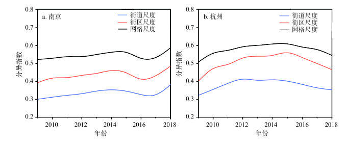
通过计算南京、杭州3个尺度、5类住宅多群体信息熵指数H和多群体标准化暴露度P,结果如图4所示。不同城市、不同尺度的两类分异指数均集中分布在0.3~0.6之间,根据欧美分异指数表征分异程度的标准判断( 分异指数小于0.3表明空间分异程度低,大于0.6表明空间分异程度高。)[69,70],宁杭城市居住空间分异程度属于“中等”;居住空间分异度表现出较强的尺度效应,空间单元越小,分异程度越高;随时间变化,同一城市不同尺度分异指数变化保持相对一致的波形走势;南京和杭州分异程度总体变化不大,差别是南京略高于杭州,表现出前期相对平稳,2014—2018年期间出现“U”型波动,均匀度指数(H)始终高于暴露度指数(P),而杭州分异指数变化呈现较为平缓的倒“U”型曲线,均匀度指数在2013年以前与暴露度指数相当,后期则越发高于暴露度指数。图4
 新窗口打开|下载原图ZIP|生成PPT
图42009—2018年宁杭多群体均匀度(H)与暴露度指数(P)
Fig. 4Multi-group evenness (H) and exposure (P) in Nanjing and Hangzhou from 2009 to 2018
为探测居住空间分异程度随尺度变化的敏感性,本文选取2018年宁杭居住空间均匀度(H)指数,分别采用基于路网距离的线性核函数(Linear Kernel)与指数核函数(Exponential Kernel)模型,构建0~3000 m的空间信息熵曲线(图5)。发现城市居住空间分异度随尺度变大而持续衰减的特征明显,符合尺度越大、分异越小的基本原则[71],而且采用指数核函数计算的H指数比线性核函数H指数衰减更快。根据分异指数随尺度衰减规律,结合社区邻里尺度特点,最终选择500 m为带宽的线性核函数模型计算空间信息熵指数
图5
 新窗口打开|下载原图ZIP|生成PPT
图52018年宁杭居住空间分异尺度衰减曲线
Fig. 5Multi-scalar profiles of residential spatial differentiation in Nanjing and Hangzhou in 2018
计算结果显示(图6),空间指数(
图6
 新窗口打开|下载原图ZIP|生成PPT
图62009—2018年宁杭基于路网的多群体空间信息熵指数(
Fig. 6Multi-group spatial information theory index (
3.2 不同住宅类型空间分异特征
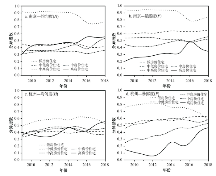
信息熵指数(H)、标准化暴露度(P)和空间信息熵指数(考虑到宁杭不同尺度空间分异指数间波形的相似性,选择街区尺度为分析对象。原因是:街道尺度空间单元偏大,反映在计算结果中为分异指数较低,难以揭示真实的空间分异情况;1 km×1 km网格空间尺度偏小且格网划分较为机械,可能因过度放大居住空间的异质性而“失真”;根据路网结构划分的街区尺度可以相对规避以上问题,更好反映实际居住空间分异情况。从图7宁杭各类型住宅空间分异的均匀度(H)和暴露度(P)指数来看:
图7
 新窗口打开|下载原图ZIP|生成PPT
图72009—2018年宁杭街区尺度不同住宅类型的空间分异程度
Fig. 7Segregation profiles of different housing groups on block scale between Nanjing and Hangzhou from 2009 to 2018
(1)低房价住宅表现出最高的空间分异程度(高均匀度和高暴露度),即在各类住宅中空间分布最不均匀,与其他类型住宅空间接触的程度最弱;其他类型住宅的均匀度指数较为接近,而暴露度指数差异较大,住宅档次越高,越容易与其他类型住宅接触;从宁杭城市低房价住宅分异指数波形与多群体分异指数波形最为相似上判断,低房价住宅的空间分异是导致城市整体居住空间异质性的主要原因。
(2)均匀度指数与暴露度指数相互关联,从图7中能够看出,相同类型住宅的两个指数在波形上极为相似,即H指数所代表的不均衡程度越高,不同类型住宅间相互接触的难度(P)就越高;同时,均匀度与暴露度指数存在内涵上的不同,暴露度更取决于群体的相对规模,例如高房价住宅占比小,接触到其他类型住宅的概率就大,各类住宅占比差距较大(表2),使得宁杭各类型住宅间的P指数差异比H指数差异更为显著。
Tab. 2
表2
表22009—2018年宁杭各类住宅规模占比(%)
Tab. 2
| 住宅规模 | 2009 | 2010 | 2011 | 2012 | 2013 | 2014 | 2015 | 2016 | 2017 | 2018 | |
|---|---|---|---|---|---|---|---|---|---|---|---|
| 南京 | 高房价住宅 | 5.10 | 2.98 | 2.59 | 3.90 | 3.79 | 3.11 | 3.14 | 8.72 | 2.79 | 2.43 |
| 中高房价住宅 | 19.09 | 14.87 | 14.75 | 15.69 | 16.21 | 16.83 | 17.11 | 18.17 | 15.45 | 15.16 | |
| 中房价住宅 | 32.14 | 30.73 | 30.20 | 30.91 | 26.86 | 25.20 | 26.96 | 23.89 | 24.44 | 30.23 | |
| 中低房价住宅 | 23.71 | 28.34 | 30.08 | 26.04 | 28.91 | 30.81 | 29.32 | 36.18 | 37.00 | 43.84 | |
| 低房价住宅 | 19.95 | 23.08 | 22.39 | 23.45 | 24.23 | 24.05 | 23.47 | 13.04 | 20.31 | 27.62 | |
| 杭州 | 高房价住宅 | 1.46 | 0.96 | 0.79 | 0.43 | 0.70 | 2.48 | 1.68 | 2.53 | 5.13 | 4.65 |
| 中高房价住宅 | 9.17 | 8.95 | 7.47 | 7.66 | 7.45 | 10.74 | 10.19 | 12.67 | 16.48 | 16.67 | |
| 中房价住宅 | 28.72 | 31.82 | 27.16 | 31.32 | 25.06 | 32.27 | 27.13 | 28.43 | 26.09 | 31.51 | |
| 中低房价住宅 | 41.54 | 37.22 | 39.13 | 34.82 | 37.53 | 31.67 | 34.44 | 33.03 | 32.92 | 32.78 | |
| 低房价住宅 | 19.12 | 21.04 | 25.44 | 25.77 | 29.26 | 22.84 | 26.56 | 23.35 | 19.37 | 14.39 | |
新窗口打开|下载CSV
(3)南京不同类型住宅空间分异水平差距大于杭州,在均匀维度上,南京低房价住宅H指数平均达到0.86以上,其他类型住宅H指数在0.3~0.6区间内,而杭州所有类型住宅均匀度指数都保持在0.3~0.6区间;在暴露维度上,2009年南京高房价与低房价住宅P指数差距达到0.74,2018年也接近0.50,杭州不同类型住宅暴露度指数差距从2009年的0.61下降为2018年的0.16;说明南京低房价住宅分布更加不均且空间上更为集聚,杭州低房价住宅空间上趋向分散而高房价住宅趋于集聚。
3.3 宁杭居住分异的结构性差异
根据南京与杭州各类型住宅空间分异指数的差值判断(图8),南京不同类型住宅空间分异指数整体上高于杭州,特别是高房价住宅和低房价住宅类型表现尤为明显。图8
 新窗口打开|下载原图ZIP|生成PPT
图82009—2018年宁杭街区尺度不同住宅类型空间分异指数差值
Fig. 8The difference of residential differentiation in different housing groups at block scale between Nanjing and Hangzhou from 2009 to 2018
为考察宁杭居住分异差异及演化的结构性原因,进一步选择高房价和低房价两种住宅类型,通过Shapley分解法对宁杭居住分异指数的差异值进行贡献率分解,结果如图9所示。宁杭居住分异差异是空间结构差异和群体特征差异共同作用的结果,空间结构和群体特征因素的贡献可能是正向(即南京分异更强),也可能是负向(即杭州分异更强),两类因素的贡献率之和形成宁杭分异指数差值;总体上看,空间结构差异的贡献率超过群体特征差异的贡献率,从空间结构要素贡献率基本为正值可以推断,空间结构差异是造成南京居住分异程度高于杭州的主导因素。
图9
 新窗口打开|下载原图ZIP|生成PPT
图92009—2018年宁杭街区尺度高、低房价住宅分异指数值差异与贡献率分解
Fig. 9The difference and decomposition of residential differentiation index of high and low housing prices between Nanjing and Hangzhou from 2009 to 2018
为更进一步探究宁杭居住空间分异的结构性差异,重点比较2018年高房价和低房价两类住宅的空间分布格局(图10)。南京高房价住宅主要集中分布在内城以拉萨路小学、力学小学、琅琊路小学为代表的顶级公办小学学区,以及河西新城的龙江片区、玄武湖周边与紫金山东麓,低房价住宅集中分布在江北北部地区;杭州高房价住宅主要分布在老城以学军小学、天长小学和求是小学为代表的“名校”学区,以及西湖东岸延安路沿线、西溪湿地周边和钱江新城等地区,低房价住宅主要分布在外围区域,特别是绕城公路周边;从宁杭差异上看,南京高房价与低房价住宅更加集聚,而杭州相对分散。
图10
 新窗口打开|下载原图ZIP|生成PPT
图102018年宁杭街区尺度高、低房价住宅规模占比
Fig. 10Percentage of high and low housing groups at block scale in Nanjing and Hangzhou in 2018
4 宁杭居住空间分异的主导因素
4.1 分异影响因素
以往研究发现,城市内部住宅价格差异主要受到交通区位、景观质量、居住品质和配套服务等多种因素的叠加影响[72]。从宁杭高、低房价住宅空间分布(图10)可看出,高房价住宅往往靠近城市核心区、毗邻山水景观、位于优质学区和重点新城新区等地段,低房价住宅则通常位于城市边缘交通区位和服务配套欠佳地区。因此,本文从区位特征、配套环境和住宅属性3个层面,选择中心、交通和景观位势,商业、休闲、教育和政策配套水平,以及住宅小区建成年代和绿化品质等9个指标(表3),采用地理探测器方法( 由于地理探测器适合分析离散型数据,为使离散化后同类数据内部的相似性和各类数据间的差异性都尽可能明显,本文在结合轮廓系数判定最佳分类数的基础上,运用K-means聚类方法对部分连续性自变量数据进行离散化处理。),探析2009年和2018年在街道、街区、网格3种空间尺度下,影响宁杭居住空间分异的主要因素及组合特征变化,并分析造成宁杭居住空间结构性差异的原因。Tab. 3
表3
表3宁杭城市住宅价格空间分异的特征变量与描述
Tab. 3
| 特征类型 | 解释变量 | 变量描述 |
|---|---|---|
| 区位特征 | 中心位势 | 街道、街区、网格中心与城市中心和最近次级商业中心距离之和 |
| 交通位势 | 街道、街区、网格内部地铁口与公交站数量 | |
| 景观位势 | 街道、街区、网格中心与大型山水景观资源的空间毗邻程度 | |
| 配套环境 | 商业配套 | 街道、街区、网格内部商业场所数量 |
| 休闲配套 | 街道、街区、网格内部休闲场所数量 | |
| 教育配套 | 街道、街区、网格所属学区教育质量 | |
| 政策配套 | 街道、街区、网格是否属于重点开发的新城新区 | |
| 住宅属性 | 住房年代 | 街道、街区、网格内部住宅距离建成年份的平均年数 |
| 绿化品质 | 街道、街区、网格内部绿化面积与规划建设用地面积的比值 |
新窗口打开|下载CSV
4.2 地理探测结果
地理探测器对单因子探测分析结果如表4所示。Tab. 4
表4
表4因子探测器分析结果
Tab. 4
| q值 | 2009年 | 2018年 | |||||||||||
|---|---|---|---|---|---|---|---|---|---|---|---|---|---|
| 南京 | 杭州 | 南京 | 杭州 | ||||||||||
| 街道 | 街区 | 格网 | 街道 | 街区 | 格网 | 街道 | 街区 | 格网 | 街道 | 街区 | 格网 | ||
| 中心位势 | 0.722 | 0.666 | 0.689 | 0.379 | 0.184 | 0.008 | 0.619 | 0.031 | 0.495 | 0.032 | 0.114 | 0.252 | |
| 交通位势 | 0.118 | 0.199 | 0.332 | 0.141 | 0.023 | 0.004 | 0.006 | 0.015 | 0.131 | 0.027 | 0.025 | 0.043 | |
| 景观位势 | 0.271 | 0.135 | 0.318 | 0.253 | 0.121 | 0.021 | 0.177 | 0.036 | 0.231 | 0.014 | 0.054 | 0.092 | |
| 商业配套 | 0.162 | 0.328 | 0.197 | 0.069 | 0.039 | 0.027 | 0.073 | 0.054 | 0.072 | 0.006 | 0.045 | 0.146 | |
| 休闲配套 | 0.258 | 0.291 | 0.218 | 0.268 | 0.121 | 0.030 | 0.185 | 0.057 | 0.190 | 0.020 | 0.049 | 0.153 | |
| 教育配套 | 0.346 | 0.402 | 0.561 | 0.428 | 0.338 | 0.157 | 0.228 | 0.039 | 0.473 | 0.437 | 0.419 | 0.400 | |
| 政策配套 | 0.030 | 0.028 | 0.092 | 0.038 | 0.000 | 0.015 | 0.022 | 0.011 | 0.167 | 0.005 | 0.001 | 0.000 | |
| 住房年代 | 0.244 | 0.188 | 0.073 | 0.182 | 0.104 | 0.183 | 0.208 | 0.039 | 0.033 | 0.284 | 0.267 | 0.059 | |
| 绿化品质 | 0.119 | 0.057 | 0.011 | 0.047 | 0.106 | 0.010 | 0.109 | 0.025 | 0.015 | 0.011 | 0.017 | 0.032 | |
新窗口打开|下载CSV
(1)在因子整体表现上,“中心位势”和“教育配套”两个因子的q值较高,即区位条件和学区质量对于居住空间分异具有最强的解释力;其次是“景观位势”“休闲配套”和“住房年代”;再次是“商业配套”“交通位势”和“绿化品质”;解释力相对较差的是“政策配套”指标。从多数指标q值偏低上判断,居住空间差异并非由单一指标决定,而是多元因素叠加作用的结果。
(2)在空间尺度效应上,街道、街区和网格层面的影响因素解释力排名具有一定相似性,比如排名靠前和靠后的指标基本保持稳定;但不同尺度间也存在明显差异,例如“中心位势”“住房年代”“休闲配套”和“商业配套”等指标在不同尺度的q值排序可能存在较大差异,说明尺度效应不仅体现在分异程度上,还体现在分异的主导因素与组合特征上。
(3)在解释度稳健性上,“中心位势”“交通位势”“休闲配套”“住房年代”和“绿化品质”等指标受尺度影响较大,在同年份同城市但不同尺度上的q值可能存在数量级上的差异,特别是在街道尺度和格网尺度之间,说明相对于内部差异显著的大尺度街道和异质破碎的小尺度网格而言,街区尺度可能更适合用于分析居住空间分异的影响因素。
(4)在宁杭城市差异上,“中心位势”在南京居住空间分异主导影响因素中占据首位,反映出南京作为传统单中心城市,“中心性”对于居住空间分异的重要作用,而“教育配套”排名第二;杭州则是“教育配套”占首位,其次是“中心位势”和“住房年代”等因素,对城市“中心性”的敏感度相对不高。
如前所述,考虑到居住空间分异的多样化因素叠加影响,本文在单因子探测的基础上,采用交互因子探测器进一步分析。从排名前十位的组合因子上看(表5),首先,双因子交互作用下对居住空间分异的解释力(q值)显著提高,并且在不同空间尺度上的稳健性亦有明显改善;其次,双因子与单因子探测结果表现出一定相似性,例如“中心位势”与“教育配套”的组合,以及两者与“景观位势”“住房年代”“商业配套”和“休闲配套”等其他因素,甚至与“政策配套”等不显著因素的组合也可能表现出较好的解释力,揭示出多因素叠加分析应是解释居住空间分异机理的更理想手段。
Tab. 5
表5
表5双因子探测q值排名前10位的组合因子
Tab. 5
| q值 排序 | 2009年 | 2018年 | |||||||||||
|---|---|---|---|---|---|---|---|---|---|---|---|---|---|
| 南京 | 杭州 | 南京 | 杭州 | ||||||||||
| 街道 | 街区 | 格网 | 街道 | 街区 | 格网 | 街道 | 街区 | 格网 | 街道 | 街区 | 格网 | ||
| 1 | 中心∩景观 (0.867) | 中心∩景观 (0.766) | 中心∩教育 (0.767) | 教育∩景观 (0.819) | 教育∩休闲 (0.686) | 年代∩教育 (0.286) | 中心∩教育 (0.832) | 景观∩绿化 (0.231) | 教育∩中心 (0.668) | 教育∩年代 (0.544) | 教育∩商业 (0.531) | 教育∩景观 (0.539) | |
| 2 | 中心∩教育 (0.855) | 中心∩教育 (0.729) | 中心∩景观 (0.765) | 教育∩休闲 (0.691) | 教育∩绿化 (0.674) | 年代∩景观 (0.238) | 中心∩景观 (0.709) | 商业∩教育 (0.191) | 教育∩景观 (0.635) | 教育∩中心 (0.527) | 教育∩景观 (0.518) | 教育∩中心 (0.514) | |
| 3 | 中心∩商业 (0.796) | 中心∩年代 (0.720) | 教育∩景观 (0.741) | 景观∩交通 (0.690) | 教育∩中心 (0.593) | 教育∩休闲 (0.225) | 中心∩绿化 (0.703) | 商业∩景观 (0.190) | 教育∩政策 (0.586) | 教育∩景观 (0.524) | 教育∩年代 (0.502) | 教育∩商业 (0.477) | |
| 4 | 中心∩政策 (0.765) | 中心∩休闲 (0.706) | 中心∩绿化 (0.725) | 中心∩交通 (0.639) | 教育∩商业 (0.532) | 年代∩中心 (0.223) | 中心∩交通 (0.697) | 休闲∩年代 (0.176) | 中心∩年代 (0.577) | 教育∩商业 (0.512) | 教育∩交通 (0.488) | 教育∩休闲 (0.474) | |
| 5 | 中心∩休闲 (0.764) | 中心∩商业 (0.701) | 中心∩年代 (0.712) | 教育∩交通 (0.627) | 教育∩年代 (0.523) | 年代∩商业 (0.223) | 中心∩年代 (0.696) | 教育∩景观 (0.175) | 中心∩绿化 (0.573) | 教育∩休闲 (0.506) | 教育∩休闲 (0.479) | 教育∩交通 (0.459) | |
| 6 | 中心∩绿化 (0.761) | 中心∩交通 (0.699) | 中心∩休闲 (0.708) | 中心∩景观 (0.622) | 教育∩景观 (0.495) | 年代∩休闲 (0.222) | 教育∩休闲 (0.684) | 商业∩交通 (0.172) | 中心∩商业 (0.560) | 教育∩绿化 (0.502) | 教育∩中心 (0.476) | 教育∩绿化 (0.458) | |
| 7 | 中心∩交通 (0.758) | 中心∩绿化 (0.693) | 中心∩商业 (0.699) | 教育∩中心 (0.617) | 中心∩绿化 (0.477) | 年代∩绿化 (0.210) | 中心∩商业 (0.675) | 商业∩绿化 (0.168) | 教育∩绿化 (0.555) | 教育∩交通 (0.486) | 教育∩政策 (0.441) | 教育∩年代 (0.451) | |
| 8 | 中心∩年代 (0.742) | 中心∩政策 (0.676) | 中心∩交通 (0.698) | 休闲∩交通 (0.616) | 教育∩交通 (0.441) | 年代∩交通 (0.209) | 中心∩政策 (0.655) | 休闲∩商业 (0.168) | 中心∩景观 (0.554) | 教育∩政策 (0.459) | 教育∩绿化 (0.436) | 中心∩绿化 (0.411) | |
| 9 | 教育∩年代 (0.740) | 教育∩商业 (0.610) | 中心∩政策 (0.691) | 中心∩休闲 (0.607) | 中心∩休闲 (0.384) | 教育∩商业 (0.208) | 中心∩休闲 (0.650) | 景观∩中心 (0.164) | 中心∩政策 (0.553) | 年代∩景观 (0.398) | 年代∩商业 (0.399) | 教育∩政策 (0.410) | |
| 10 | 教育∩景观 (0.688) | 教育∩休闲 (0.579) | 教育∩休闲 (0.656) | 教育∩绿化 (0.566) | 教育∩政策 (0.377) | 教育∩景观 (0.196) | 教育∩景观 (0.644) | 休闲∩教育 (0.162) | 教育∩休闲 (0.550) | 年代∩休闲 (0.396) | 年代∩景观 (0.380) | 中心∩景观 (0.363) | |
新窗口打开|下载CSV
4.3 宁杭差异原因
由上文可知,宁杭(不同城市)街道、街区、网格(不同尺度)2009年和2018年(不同时间)住宅价格空间分异的主要影响因素表现出一定相似性,教育质量、中心区位、景观环境、休闲和商业配套等外部因素,以及房龄等住宅自身属性,均会影响城市住宅价格,而影响因素间可能存在明显的内在关联,比如城市中心区通常具有优质的教育资源和丰富的休闲、商业配套。不同要素的叠加影响和共同作用形成城市住宅价格的空间分异格局。基于此判断,结合南京与杭州的实际情况,分析宁杭街区尺度高、低房价住宅的空间分异格局及差异性成因:① 南京以新街口地区、杭州以武林广场—湖滨地区为核心,呈现出鲜明的“强中心”特点。尽管伴随城市规模扩张,郊区副中心和新城新区不断培育壮大,但宁杭老城区依然集聚着最顶级的公办中小学、最优越的区位条件和最完善的配套服务,老城外围则拥有更好的景观环境和住宅品质,因此高房价住宅主要集中在老城的名校学区,以及南京河西新城、玄武湖畔、紫金山下,杭州钱江新城、西湖风景区和西溪湿地周边等地区。② 南京江北、老下关和杭州萧山、下沙、良渚等地区远离城市中心,教育、商业、休闲等配套设施较老城区相对欠缺,成为低房价住宅的集聚区,但南京江北(浦口北部、六合南部)位于城市边缘,区位交通、服务配套和景观环境等与主城区存在较大落差,一直是住宅价格洼地,而杭州萧山和下沙与主城区的各项差距相对较小,因此,南京低房价住宅更加集聚而杭州更趋分散,这种结构上的差异导致南京住宅空间分异高于杭州。
通过对宁杭居住空间分异指数、格局与影响因素的比较,可看出两个城市既有共性亦有差异,这种比较虽然增加了分析的困难,却可以更好规避依靠单个城市的经验总结可能带来的偏差风险,而且对共性规律的掌握更有利于提出切实有效的居住分异调控建议。例如从宁杭比较来看,由于城市空间结构因素对居住分异影响较大,推动城市向多中心结构转变,促进义务教育和商业休闲等配套服务的空间均衡,或可作为控制城市居住分异或隔离的有效手段。
5 结论与讨论
5.1 结论
通过将城市居住分异解构为耦合互动的社会—空间两个维度,提出住宅空间作为居住分异的物质维度属性,因具有时间连续且时效性强、尺度划分灵活和空间位置准确等优势,可以更加及时、动态、精准描刻居住空间分异,真实呈现城市居住分异的复杂性和层次性。以住宅价格为测度指标和分类标准,采用多群体空间分异指数等方法,发现空间分异指数因考虑到空间位置和邻域环境,在一定程度上可以对传统非空间分异指数产生改进作用,从而更真实反映城市居住分异程度。宁杭城市共性与差异并存,中心区位和教育质量成为影响城市居住空间分异的重要因素,而南京居住空间分异高于杭州,归因于其更为显著的“核心—边缘”空间结构。居住空间分异意味着城市社会空间资源配置的失衡,为避免城市社会空间极化和促进阶层正常流动,地方政府应采取加强房地产市场的调控与监管、建立多元化的住房保障体系、构建多中心城市空间结构和促进公共服务设施均等化配置等路径,适当控制城市居住分异程度,保障新时代城市社会空间的健康可持续发展。
5.2 讨论与展望
本文聚焦城市居住分异这一经典课题,试图从以下方面进行创新:① 采用具有空间灵活性和前瞻预测性的住房视角开展居住空间分异研究;② 结合多时空尺度和多群体“空间分异指数”测度城市居住空间分异水平;③ 比较宁杭居住空间分异指数差异并将其分解为空间结构和群体特征贡献。不可否认,作为一项探索性研究,本文还存在一定局限性,例如住宅空间与社会群体具体存在怎样的相互作用与对应关系?住宅价格指标是否能够全面表征居住分异的物质维度属性?无论非空间指数还是空间指数,其数值的实际意义如何解读?是否存在判断居住分异程度高低的标准?不同城市间的居住分异指数是否具有可比性?以及分异指数随时间变化出现不同波形的原因等,都是需要后续加强研究的重点方向。居住分异的社会—空间二维属性,意味着必须基于社会群体和住宅空间综合视角,才能全面刻画在单位制度惯性延续与市场力量冲击重塑的交织与混合影响下,融合不同时代特征的社会空间拼叠景观,从而避免“盲人摸象”般地片面解读。因此,为进一步拓展中国城市居住分异的理论与实证研究深度,需要完善和创新的领域有:构建整合相关概念、融合多维要素的居住社会—空间耦合理论框架和研究体系;结合人口普查、问卷调查等群体属性数据和住房市场、POI/AOI等空间属性数据,系统开展城市居住分异社会—空间耦合模式、路径、机制与效应研究;不断探索可以整合多指标、适合多群体和多尺度的居住分异测度方法,提出符合中国国情实际、适用不同类型城市的分异程度衡量标准,并将研究侧重从城市是否存在居住分异及其程度,逐渐转向对分异指数内在意义和居住分异调控手段的探讨。
参考文献 原文顺序
文献年度倒序
文中引用次数倒序
被引期刊影响因子
[本文引用: 1]
DOI:10.1177/0309132515618104URL [本文引用: 1]
[本文引用: 1]
[本文引用: 1]
DOI:10.1080/00330124.2019.1578977URL [本文引用: 1]
DOI:10.1111/j.0081-1750.2004.00150.xURL [本文引用: 4]
DOI:10.1080/02673037.2016.1210100URL [本文引用: 1]
DOI:10.1016/j.cities.2015.03.002URL [本文引用: 1]
DOI:10.1016/j.cities.2019.102469URL [本文引用: 2]
DOI:10.1080/02723638.2020.1724439URL [本文引用: 1]
[本文引用: 1]
[本文引用: 1]
DOI:10.11821/dlxb201704003 [本文引用: 3]

Spatial differentiation of urban housing prices is the marketization expression of the non-equilibrium allocation of residential space resources, which reflects the contrast between social groups belonging to different social classes in selection preference and demand for housing. There is a certain degree of correlational coupling between urban housing prices' spatial differentiation and residential spatial differentiation with respect to the mechanism and the pattern. The paper chooses 1204 commercial housing communities in Nanjing's urban center as its research object and constructs a characteristic variable index system of housing prices. The GWR model is used to analyze major factors that lead to spatial differentiation in housing prices, as well as their combination relationship and spatial-temporal dynamics. Results demonstrate that: (1) there are various factors affecting housing prices, their subsequent spatial differentiation, and they are likely to evolve over time. The dominant factors are the level of the community, school district resources, quality of the landscape, access to leisure facilities, and so on. These may mainly reflect housing consumers' earning capacity, values, residential environment demands, life style and cultural tastes. (2) The pattern of housing prices in Nanjing generally shows the spatial pattern of "circle + fan-shaped + enclave". High priced housing mainly includes new apartments and gated communities in the inner city, communities in elite primary and secondary school districts, high-grade gated communities close to the Ming City Wall, housing in the center of Hexi New Town, and landscaped villas in the urban periphery. (3) Differing types and strata of housing communities attract and gather consumer groups with specific economic and social attributes, which makes housing price differentiation notable correlational coupling with residential differentiation in acting mechanisms and spatial patterns. As the degree of urban housing marketization is continuously deepening and the cultural characteristics and residential preference of social classes become increasingly mature, the spatial differentiation of urban housing prices is more than just an expression. It is also an important driving mechanism to promote residential spatial differentiation and re-differentiation, and can also predict basic trends pertaining to urban residential spatial differentiation in the future. Therefore, the spatial differentiation of urban housing prices can provide a prospective observational and analytical tool for the study of urban social space. It can further make up the time-lag defect which arises in traditional social space research using census data, as well as helps to predict and identify future trends regarding urban social spatial differentiation.
[本文引用: 3]
URL [本文引用: 1]
DOI:10.1177/0042098017721828URL [本文引用: 1]
[本文引用: 1]
[本文引用: 1]
[本文引用: 1]
[本文引用: 1]
DOI:10.13249/j.cnki.sgs.2020.01.006 [本文引用: 1]
In the context of citizenization, the research of migrant identity is of great significance to promote social integration and people-oriented urbanization. The existing studies have paid little attention to the dual identification mode of migrants, that is, identification with the city is not necessarily separated from the identification with their hometown. This study, drawing data from the Survey of Social Integration and Mental Health of Migrants in 2014, analyses migrants’ identification patterns, characteristic and influence factors based on the migrants’ identification of hometown and city. Firstly, the results show that migrants have four identification patterns including integration, assimilation, separation and marginalization, and in general migrants have low identification with the city. Secondly, migrants’ identity is significantly affected by the factors related to the city where they live and their hometown, such as urban housing, neighborhood type, urban discrimination experience, adaptation to urban life, nostalgia emotions and hometown lands. Thirdly, our study identified that a developmental path for different identification patterns, which is from separation to integration and then to assimilation, but some migrants’ identity also would change from separation to marginalization if without policy intervention. Last but not the least, assimilated migrants are healthier and happier than the other types. According to above findings, we suggest that policy makers should consider both city and hometown factors to promote social integration for migrants, and try the best to achieve assimilation in terms of migrants’ identification with the city.
[本文引用: 1]
[本文引用: 1]
[本文引用: 1]
DOI:10.5194/essd-11-1385-2019URL [本文引用: 1]
[本文引用: 1]
[本文引用: 1]
DOI:10.11821/dlyj201811009 [本文引用: 3]
In the study of urban socio-spatial evolution, the residents committee could be taken as the basic unit of analysis because it has a relatively similar socio-economic status. It might be more accurate to assess the residential differentiation and segregation degree and reduce the underestimation effect using the data of residential committees. Based on the Shanghai population geographic information database and census data obtained from 2000 and 2010 with statistical units of the residents committee, the present study used the local differentiation index and spatial analysis methods to describe the characteristics of urban residential differentiation and social space evolution in Shanghai under the background of globalization and marketization in dual dimensions of the Hukou and the occupation. The results demonstrated that in Shanghai, the residential differentiation characteristics were apparent and the "core-periphery" socio-spatial structure formed before 1949 was largely unchanged. Consequently, inner city of Shanghai experienced rapid gentrification and white-collar gathering during the last two censuses. The residential space of the elite class was closer to the city center, and the residential space of ordinary white-collar social classes were further marginalized with urban expansion. This confirmed other scholars' opinions on the marginalization of white-collar workers and the differentiation of the middle class based on case studies. The inter-provincial immigrant residential areas shifted from the edge of the central urban area to the area outside the central city, and further to the outer suburbs. Transnational and native elites dominated the space production - the reproduction of social relations, which brought about long-term stability of urban social space in Shanghai. At macro-scale, the residential differentiation in the occupation dimension was more obvious than that of the Hukou dimension. At micro-scale, the urban residential segregation index climbed quickly, while the residential differentiation in the Hukou dimension truly existed, which was independent of the occupation difference. The disadvantaged group gathered in the marginal social space and social inequality might be more severe in the future. Therefore, more attention should be paid to the social equality governance in the urban space and further analysis should be made on the social space characteristics, space power relations, and space logic of Chinese large cities.
[本文引用: 3]
[本文引用: 3]
[本文引用: 3]
DOI:10.11821/dlxb201612002 [本文引用: 1]
As a result of socio-economic development, the middle class in China has grown considerably and has gradually become an important social group, and its expanding housing demand has exerted a profound effect on the socio-spatial structure of cities. This paper analyzes the spatial differentiation and formation mechanism of the middle class social area in Guangzhou to provide a reference for the policy implications of social development planning and urban planning and redevelopment. Based on the fifth and sixth censuses, 148 sub-districts from 10 districts of Guangzhou in 2010 are divided into five social areas—mixed class, middle class, salaried workers, peasant class, and working class—by principal components analysis hierarchical cluster methods, and the spatial distribution and characteristics of the middle class social area are analyzed. Next, using a concentration index, the middle class community is divided into four sub-areas: the educational middle class, the professional middle class, the income middle class, and the mixed middle class. The same approach is then used to examine the spatial distribution and characteristics of the middle class social area in 2000. In comparison of the results from 2000 and 2010, it can be seen that the middle class social area in Guangzhou has experienced the following changes: (1) The middle class social area is expanding, with evident suburbanization and centralization. (2) The suburban area, the banks of the Pearl River, and the economic development zone are the main areas where the middle class is concentrated. (3) The agglomeration of a floating population in the urban villages is leading to the disappearance of the middle class social area. (4) In each sub-social area of middle class, the number and the sub-social area they belonged to have been changing from 2000 to 2010. (5) The middle class social area can be divided into four subtypes according to their changing condition: a stable type, an unstable type, a decaying type, and a growing type. Finally, this paper analyzes the mechanism of the change in the middle class social area from the perspectives of social strata polarization, real estate, globalization, the historical continuity of traditional social space, individual behavior, and urban construction.
[本文引用: 1]
DOI:10.13249/j.cnki.sgs.2017.06.008 [本文引用: 2]
The housing issues of China’s urban residents have always been the focus of academic circles. The issues regarding housing conditions in China's megalopolises are important topics of research for building livable cities, resolving the housing shortage, and solving the urban problem. The inequality of urban housing conditions is also an indispensable issue. However, to date, specific research on the differentiation pattern and spatial structure of housing conditions in China's cities is rare. Therefore, based on housing data from the newly available sixth census of 2010 for Guangzhou’s metropolitan areas, we established a comprehensive system for evaluating housing conditions that is composed of housing years, building structure, building area per household, and housing facilities and explored the spatial differentiation pattern of housing conditions. Furthermore, we analyzed the spatial cluster and heterogeneity of housing conditions by using the ESDA and GDI index. Finally, we summarized the spatial differentiation model and formation mechanism. The results are as follows: 1) The housing conditions of Guangzhou, gradually improving from the center to periphery, show significant imbalance and spatial cluster characteristics. Regions with better and worse housing conditions have specific location directions. Housing years and building area per household are two core indicators that decide the differentiation of housing conditions. 2) The housing conditions of the evaluation subsystem are distinct among different urban circles. In the old city, the scores of housing years, architectural structure, and building area per household are lower. In the core area, scores of the building area per household and housing infrastructure are higher than in other regions. In the central area, the level of the architectural structure is highest. In the suburbs, the housing years are the lowest. In addition, the heterogeneity of housing conditions in the old city is the highest. 3) The historical process of urban development, housing exchange and filtering effects, and high housing and land prices influence and enhance the spatial differentiation pattern of housing conditions in Guangzhou. Institutional factors, government decision making, and market forces also play a role in guiding and promoting the pattern. Thereto, institutional factors include the urban-rural dual-land system, housing dual-supply system, and housing demolition requisition system. Government decision making mainly refers to the urban development strategy and urban planning. Market forces reflect relationships between housing price, housing conditions, location, and household income.
[本文引用: 2]
[本文引用: 1]
[本文引用: 1]
DOI:10.11821/xb198904001 [本文引用: 1]
The approach to studying the social spatial structure of cities has become very popularin the western countries since the first study of social area analysis was undertaken by Shevkyet al. in 1950s. During 1960s, this approach area was developed by using the technique of fac-torial ecological study. This technique has two characteristics. First, a large number of va-riables are used in the factor analysis or the principal components analysis, in order to extractsome major factors of social and residential differentiation. Second, it places much greateremphasis on the spatial patterns associated with those factors.
[本文引用: 1]
DOI:10.1016/j.cities.2014.02.011URL [本文引用: 2]
[本文引用: 1]
[本文引用: 1]
[本文引用: 1]
[本文引用: 1]
DOI:10.2747/0272-3638.26.2.167URL [本文引用: 1]
DOI:10.1111/j.1475-5661.2008.00304.xURL [本文引用: 1]
DOI:10.1177/0042098019834233URL [本文引用: 1]
[本文引用: 1]
[本文引用: 1]
[本文引用: 1]
[本文引用: 1]
DOI:10.1177/2399808318808889URL [本文引用: 1]
DOI:10.1146/annurev-soc-081715-074333PMID:30089937 [本文引用: 1]
Few sociologists treat housing as a key independent variable, despite the emergence of disparate bodies of research analyzing how housing affects outcomes that traditionally interest sociologists. Scholars across the social sciences have proposed and tested mechanisms whereby housing could shape subjective well-being, socioeconomic status, demography, and politics. We review the evidence for causal effects across these domains. Next, we make recommendations for research designs to advance this literature. Most studies only test effects of homeownership, and most are focused on the United States and Western Europe. The evidence for causation is often weak, although studies increasingly employ complex techniques for identifying effects. Throughout, we emphasize studies beyond the United States, and we conclude by discussing distinctive insights yielded by comparative research. We advocate for a comparative perspective and more expansive conceptualization of housing status as a means to build theory and evidence regarding the conditions under which housing exerts effects.
[本文引用: 1]
DOI:10.1080/02673037.2020.1793915URL [本文引用: 2]
DOI:10.1080/17538963.2015.1110338URL [本文引用: 1]
DOI:10.15195/issn.2330-6696URL [本文引用: 1]
[本文引用: 1]
[本文引用: 1]
DOI:10.1186/s40711-019-0113-1URL [本文引用: 1]
DOI:10.1080/21620555.2019.1601012 [本文引用: 1]
Housing has become a major dimension of socioeconomic inequality in contemporary China. This study investigates the effects of homeownership and housing wealth on people's subjective class identification in urban China. Using the data from the China Family Panel Studies (CFPS) from 2010 to 2016, we estimate fixed-effects models and show that growth in housing wealth improves people's perceived social status, and the improvement is greater in more economically developed areas with higher real estate prices and greater housing inequality. Owning a home enhances subjective social class only in eastern coastal regions but not in inland regions. These findings suggest that as homeownership expands and becomes universal in a society, the psychological benefits of homeownership may diminish, but the subjective impact of housing wealth would increase. The study contributes to the literature on the social consequences of housing in a transitional society that is experiencing rapid housing privatization and increased housing stratification.
[本文引用: 1]
[本文引用: 1]
DOI:10.1007/s10708-020-10138-yURL [本文引用: 1]
DOI:10.1177/2399808318760572URL [本文引用: 1]
DOI:10.1111/tran.2018.43.issue-1URL [本文引用: 1]
DOI:10.1080/00045608.2015.1066739URL [本文引用: 1]
DOI:10.2307/2579183URL [本文引用: 2]
DOI:10.1086/227768URL [本文引用: 1]
DOI:10.2307/142171URL [本文引用: 1]
[本文引用: 1]
[本文引用: 1]
DOI:10.2307/622300URL [本文引用: 1]
DOI:10.1111/cag.1997.41.issue-2URL [本文引用: 1]
DOI:10.1111/1467-9531.00112URL [本文引用: 1]
[本文引用: 1]
DOI:10.2307/270845URL [本文引用: 1]
DOI:10.1016/j.compenvurbsys.2018.05.001URL [本文引用: 1]
DOI:10.13249/j.cnki.sgs.2014.010.1184 [本文引用: 1]
Regional inequality is an important issue in geographical research and regional development studies. China is the largest developing country in the world and its economy has undergone rapid and continuous expansion since the Chinese economic reform in 1978. China has achieved great success in economic development with an annual growth rate at 9.9%. However, behind the economic success in China, the country also faces serious challenges arising from imbalanced growth and intensifying social injustice. Since regional inequality may threaten national unity and social stability, it is a hot issue in research internationally and domestically. Almost all previous studies of the regional inequality have transformed static, qualitative measurement into a dynamic and quantitative evaluation. Most of the research in China has focused on lateral comparisons at a national level, only a few have addressed the provincial level. Added this above, this article analyses the regional inequality in Guangdong Province from 1990 to 2010 and follows a GIS-based multi-scale and multi-mechanism framework. Conventional global inequality indexes, spatial autocorrelation and spatial multi-level regression are utilized in the article to examine the regional inequality in Guangdong Province. Conventional global inequality indexes (including Coefficient variance, Gini coefficient, Theil index) analysis reveal that since the early 1990s, the regional inequalities at county level, municipality level, regional level and urban-rural level are experiencing increasing tends and fluctuated change. Geographical scale and spatial organization play an important effect on regional inequality. Based on GIS, spatial autocorrelation finds that spatial agglomeration-"convergence club" exists in the process of economic growth of Guangdong, which is attributing to intensity the regional inequality. The spatial multi-level regression analysis reveals that globalization, decentralization and investment are the three important mechanisms for understanding the regional inequality in Guangdong Province, and marketization has remitted the regional inequality effectively. What′s more, urban-rural and geomorphology are also the elements of the regional inequality, but the impact is not significant.
[本文引用: 1]
DOI:10.1177/2399808319843928URL [本文引用: 1]
DOI:10.1016/S0198-9715(01)00018-7URL [本文引用: 1]
DOI:10.1177/0894439313504539URL [本文引用: 1]
DOI:10.1080/13658810600911903URL [本文引用: 1]
DOI:10.1080/17421772.2019.1593495URL [本文引用: 1]
[本文引用: 1]
DOI:10.1016/0304-3878(92)90001-PURL [本文引用: 1]
DOI:10.1177/0081175017692625URL [本文引用: 1]
DOI:10.1007/s11769-020-1144-xURL [本文引用: 1]
DOI:10.11821/dlxb201701010 [本文引用: 1]
Spatial stratified heterogeneity is the spatial expression of natural and socio-economic process, which is an important approach for human to recognize nature since Aristotle. Geodetector is a new statistical method to detect spatial stratified heterogeneity and reveal the driving factors behind it. This method with no linear hypothesis has elegant form and definite physical meaning. Here is the basic idea behind Geodetector: assuming that the study area is divided into several subareas. The study area is characterized by spatial stratified heterogeneity if the sum of the variance of subareas is less than the regional total variance; and if the spatial distribution of the two variables tends to be consistent, there is statistical correlation between them. Q-statistic in Geodetector has already been applied in many fields of natural and social sciences which can be used to measure spatial stratified heterogeneity, detect explanatory factors and analyze the interactive relationship between variables. In this paper, the authors will illustrate the principle of Geodetector and summarize the characteristics and applications in order to facilitate the using of Geodetector and help readers to recognize, mine and utilize spatial stratified heterogeneity.
[本文引用: 1]
[本文引用: 1]
[本文引用: 1]
DOI:10.1007/s40980-018-0044-5URL [本文引用: 1]
DOI:10.11821/dlxb201810005 [本文引用: 1]
The growth and spatial differentiation of housing price is a theoretical issue continuously discussed in the field of urban geography, and even a practical problem relating to whether urban residents could realize the goal of living a good life in their own residences. The paper chooses 3761 independent residential districts (or residential clusters) in Nanjing as research objects, and analyzes sample data of 30 quarters in 2009-2017 of each residential district; on this basis, it focuses on the spatial differentiation pattern and evolution process of residential price in Nanjing. It finds that, on the whole, the housing price in Nanjing presents the staged rule of mutually alternative of "fast growth" and "relative stability" in one and a half year; while, high-price residences are mainly in Hexi New Town and the districts of famous schools, as well as high-rise service apartments distributed in inner urban areas, gated communities with landscape at the periphery, and high-grade villas in suburbs. Based on the consideration of the price level, location characteristics and building attributes of residential districts, this paper has comprehensively divided the residences in Nanjing into nine typical types, those are in inner city: (a) the multi-story traditional residences, (b) high-rise apartment residences, and (c) residences within the districts of famous schools; in the peripheral areas: (d) the urban new center residences, (e) landscape-area residences, (f) other gated residences; in the suburbs: g) the residences in core areas of new towns, (h) high-grade villa residences, and i) residences in urban fringe area. The comparison of the price growth process of different residences shows that, a close connection exists between the spatial attribute of residences (centrality, comfort, and scarcity) and the characteristics of housing price growth (rapidity, stability, sustainability). This paper summarizes four models of housing price growth of residences in Nanjing, namely, leading pattern, following pattern, growth-chasing pattern, and independent pattern. In addition, it analyzes the main internal and external driving forces for the differentiation of housing price growth of different types of residences. On this basis, it discusses the deep effects of the rapid and differentiated growth of housing price on the urban social space reconstruction in Nanjing, including enlarging the gap between the rich and the poor, crowding out the middle- and low-income population, solidifying the residential spatial differentiation, etc. The study on the growth of residential housing price and its aftereffects with Nanjing as an example, which is a typical big city in China, would have a certain reference for relevant research on the general fast growth and spatial differentiation of housing prices in China after the global financial crisis in 2008.
[本文引用: 1]
