 ,1,2,3, 吴绍洪3,4, 刘鸿雁5, 杨晓燕1,2,6, 刘建宝1,2,3
Disciplinary structure and development strategy ofphysical geography in China
CHEN Fahu,1,2,3, WU Shaohong3,4, LIU Hongyan5, YANG Xiaoyan1,2,6, LIU Jianbao1,2,3收稿日期:2021-04-12修回日期:2021-08-18
| 基金资助: |
Received:2021-04-12Revised:2021-08-18
| Fund supported: |
作者简介 About authors
陈发虎(1962-), 男, 陕西丹凤人, 博士, 研究员, 中国科学院院士, 发展中国家科学院院士, 中国地理学会会士(S110004201M), 主要从事气候环境变化及史前人—环境相互作用研究。E-mail:

摘要
关键词:
Abstract
Keywords:
PDF (923KB)元数据多维度评价相关文章导出EndNote|Ris|Bibtex收藏本文
本文引用格式
陈发虎, 吴绍洪, 刘鸿雁, 杨晓燕, 刘建宝. 自然地理学学科体系与发展战略要点. 地理学报, 2021, 76(9): 2074-2082 doi:10.11821/dlxb202109002
CHEN Fahu, WU Shaohong, LIU Hongyan, YANG Xiaoyan, LIU Jianbao.
1 自然地理学学科形成
自然地理是研究地球表层自然环境的空间特征、演变过程及其地域分异规律的一门自然科学,以自然科学属性为主。自然地理学研究人类生存的自然环境,涵盖气候、地貌、水文、土壤、生物等自然地理要素[1]。传统的自然地理学可以划分为部门自然地理学和综合自然地理学,其中部门自然地理学开展以单一自然地理要素为主的研究,综合自然地理学研究景观、土地等自然地理综合体。近年来,针对沙漠和湖泊湿地等特定地表单元、冰川和冻土等特殊自然地理要素的研究,以及流域系统乃至整个地球表层系统的多要素或全要素研究得到了发展。针对过去人与环境相互作用,自然地理学开展史前人群扩散、社会发展和文明演化的人类生存环境研究,理解史前和历史时期人地关系在不同时间尺度和空间尺度的相互作用,构成了自然地理学与考古学、人类学等学科交叉的新领域。自然地理学是地理科学的基础学科[2,3,4],也是地理科学与地球科学其他学科联系的纽带[5,6]。中国现代自然地理学起步于20世纪20—30年代,至50年代,系统、科学、全面的自然地理学逐步发展起来。初期以自然环境和自然资源摸底为目标,实施大规模区域综合科学考察,为地理区域划分、国家与地区有计划地建设发展,提供了可靠的科学依据,在此过程中获取了第一手研究资料,奠定了中国自然地理学研究的基础[7]。随着科学技术的快速发展,中国自然地理学逐步应用各种新技术和新方法,取得了长足的进展,研究由定性描述向定量实验推进,同时由单一过程向综合研究深化[8]。在传统的和分支学科具有区域特色的青藏高原隆升与内陆干旱化、青藏高原冰冻圈环境(冰川、冻土)、季风与西风气候变化等领域开展了多时间尺度的系统研究,在全球变化区域响应方面也取得了突出成就。针对湖泊污染与水土流失,开展了卓有成效的机理与应对措施研究。在区域自然地理环境的特征、类型、分布、过程方面取得了重大进展,推动了中国自然地理地带性规律的认知。中国的自然地理学研究特别聚焦过去不同时空尺度的人与环境相互作用这一体现地理学核心思想的研究,跨越旧石器时代、新石器时代、历史时期直至现代的长时间尺度,探讨了人与环境关系的演化规律,逐步形成了综合自然地理学、部门自然地理学和前沿学科—人类生存环境学3个分支体系(图1)。
图1
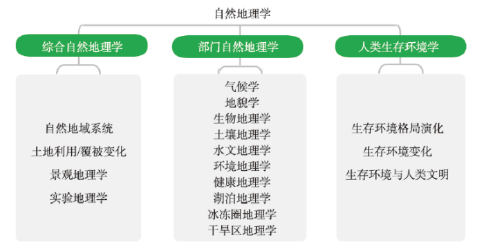 新窗口打开|下载原图ZIP|生成PPT
图1自然地理学及分支学科
Fig. 1Physical geography and its sub-disciplines
2 分支学科特征
2.1 综合自然地理学研究
随着人类活动和气候变化影响陆地表层系统的强度日益加剧,自然与人文要素以及自然—社会经济复合系统的脆弱性发生变化,自然地理学综合研究的理论和方法不断拓展和深化[9,10]。研究对象上,从自然要素与过程综合,向自然和人文要素与过程综合发展,并通过学科交叉拓展到地球关键带研究。综合研究范式上,非线性耦合反馈方法论逐渐取代单向线性方法论,分析工具和数据来源也日益多样。研究方向上,从自然地域系统研究以静态刻画为主向动态演变深化[11],土地系统科学研究从结构与驱动力向近远程耦合与服务形成机制深化,典型区域地表过程研究向格局—过程耦合研究深化,人地耦合系统从概念框架到演变机制深化。进入21世纪以来,中国的综合自然地理学整体保持国际先进水平。① 自然地域系统研究:融合生态系统和气候变化概念,自然区划向“生态”转向,生态地理地域系统研究取得重要突破,完成生态地理区划和气候变化风险区划[8, 12-13],中国自然地理学家主导的美丽中国建设研究直接服务国家需求。② 土地利用/覆被变化和景观生态研究:从格局与过程向生态系统服务及其权衡决策和优化调控方向发展,包括定量化、驱动机制、模型、效应、土地可持续利用与国土生态安全等方面的研究。③ 典型地域研究:建立了以黄土高原为代表的自然地理格局—过程—服务的耦合研究模式;黑河生态—水文—经济系统模型,形成了集观测—模型—决策为一体的流域科学集成研究范式。④ 学科的研究技术与方法论:遥感、地理信息系统、地理数据库、机理模型、大数据挖掘等现代观测分析技术,支撑了从过去对地理环境变化现象的文字描述和定性分析转向抽象概括、概念模型、机制诊断、定性与定量相结合发展,促进了因果联系与过程耦合研究和未来趋势模拟预估。整体来看,形成了具有中国特色的自然地理学综合研究模式[14],为国家和区域重大战略需求和决策应用提供了重要的科学支撑[6]。
为深入揭示地理动态过程并给出定量结果,黄秉维于20世纪50年代提出在地理学中引入数理化、生物等学科知识和新技术,开展地表实验研究,研究陆地表层系统的物理过程、化学过程、生物过程,研究地表能量转换物质迁移的规律性。基于此,中国自然地理学界开始重视野外定位实验研究,兴办了野外实验站,推动了地理学由单一区域性的工作到点、片、面相结合,由以定性为主到定性定量相结合的重要转变[15],并逐步形成了以定位观测分析手段和实验测试分析来揭示人类生存环境的时空差异的实验地理学。1988年中国科学院组建了中国生态系统研究网络(CERN),系统规范了野外站点生物、气候、土壤等共同的观测指标,通过一定的技术流程、规范和设备实现观测指标和数据统一,同时对生态系统结构与功能、格局与过程的动态变化进行连续追踪与比较,探索生态系统管理优化模式[16],以及现代的人与环境相互作用的实验模拟。21世纪初,在中国科学院CERN观测网基础上,启动了国家生态系统观测研究网络台站,涵盖了全国的主要生态系统类型与关键区域,由18个国家农田生态站、17个国家森林生态站、9个国家草地与荒漠生态站、7个国家水体与湿地生态站等共同组成。由自然地理学家和景观生态学家主导的这一持续工作,促进了中国生态建设和农业生产科技水平,推进区域产业发展[17]。
2.2 部门自然地理学研究
进入21世纪以来,中国部门自然地理学研究在若干前沿领域保持了与国际同步,部分关键区的若干领域研究逐步走向国际领先。气候学研究紧密结合地理学科的独特性,抓住和依托全球变化新机遇,研究外延不断拓展,与其他学科的交叉、融合特征越来越显著。地貌学主要在地貌成因、全国地貌类型区划、数字地貌特征信息获取等研究方面取得显著进展。水文学研究在地表水文过程的研究方向逐渐进入第一研究方阵,研发了中国的代表性径流、蒸散模型[18,19]和遥感降水数据产品[20],发展了针对全球变化下地表水文过程的系统集成模拟模式[21]。土壤地理学研究建立了土壤系统分类系统,开展了数字土壤制图并建立了中国土壤数据库。生物地理学研究紧密围绕全球变化和生物多样性2个主题,开展了关键区域和关键类群的研究,保持了与国际同步。沙漠、湖泊湿地、冰川冻土(尤其是冰冻圈)和生态水文的研究则紧密围绕国家需求,立足学科前沿,实现了系统性的突破。2.3 人类生存环境学研究
人类生存环境学是地理科学中专门针对人类生存环境的时间变化及其过去人—环境相互作用研究的自然地理学与人文地理学、人类学、考古学等的特色交叉学科。它涉及“人”及其生存的“环境”2个核心要素,包括生存环境格局形成演化、过去人类社会发展与自然环境的相互作用。中国的人类生存环境研究目前处于国际前列,关于中纬度亚洲内陆干旱区全新世气候变化的“西风模态”、青藏高原阶段性隆升拼合、极端环境形成演化、亚洲干旱环境格局演化、沙漠—沙地扩张与收缩及其环境效应方面,无论是在技术方法和理论发展方面,都处在先进地位[2-3, 22-24]。目前,国际上以碳循环和人类起源演化牵引的生存环境格局变化均处于快速上升阶段;通过对土壤、植被、海洋等碳库动态的全面系统研究,揭示全球碳库/碳汇的作用和效率,探索大气CO2变化与全球温度变化的联系;结合高精度的测年技术和基因测序技术,揭示自然地理要素的时空变化规律及人类行为的适应和影响;气候环境重建的地质载体及代用指标趋向多样化,使定量研究成为可能,并借助数值模拟和大数据技术的综合集成研究,为人类生存环境提供更全面、宏观和细致的图景。
20世纪初国际上提出“以人类为中心的古生态学(Anthropocentric Paleoecology)”概念[25]。在这一发展过程中,对人—环境关系的认识从简单的线性相关到以人为中心的古生态学系统,反映了从现象描述到机制性研究的学科发展过程。相应地,研究内容也从单一遗址的环境重建扩展到人类起源和扩散、农业起源、文明起源、人类世等人类社会发展重大里程碑事件与其所处的生态系统的动态关系研究上。测年技术、遥感技术、动植物遗存分析、同位素分析、大数据集成等方法和理论被引入这一领域的研究,传统学科获得新生,形成了新的学科增长点,并迎来新的发展机遇。21世纪以来,古DNA、古环境(沉积物)DNA、古蛋白等分子生物学技术的应用,使开展人群扩散、人类社会发展与地球各圈层的相互影响的深入研究成为可能。近年来,随着这些新手段、新技术应用和新思想的涌现,中国以开展史前人—环境作用为主的人类生存环境学研究取得较大进步,新成果不断涌现,例如深化了对粟和稻起源驯化的认识[26,27],发现跨大陆农业扩散推动了史前人群在全新世晚期大规模永久占据高海拔的青藏高原[28],发现了已消逝的丹尼索瓦古老型智人在距今16万年就生活在青藏高原东北部[29],而且可能持续生活在这一区域到距今4.5万年[30]。这一领域研究不断有新成果涌现,已是自然地理学中的一个重要新兴研究方向,其研究重点是探索不同时期、不同空间尺度人类生存环境的宜居性,服务人类及其社会发展的可持续。
3 发展战略布局
中国自然地理学研究的历程显示,国家发展需求带动了自然地理学的整体发展。中国自然环境要素丰富多样,具有显著的格局差异和独特的区域特色。悠久的人与环境相互作用历史,以及久远的从直立人到现代智人的演化和连续的文明演化历程,使中国自然地理学研究整体水平逐步进入国际研究前列。活跃的自然地理****的国际合作促进了中国自然地理学研究始终立足国际前沿;坚持观测—分析—模拟—预测相结合的现代化研究手段和方法是推动中国自然地理学研究达到国际领先水平的途径。中国自然地理研究仍将以综合自然地理学、部门自然地理学、人类生存环境学3个方面布局进行深入研究。3.1 综合自然地理学研究
针对关键陆地表层要素多尺度时空变化特征、相互作用效应,深入揭示陆地表层要素与格局的驱动机制,在陆地表层自然地域系统引入动态理念,研究动态变化规律,预估未来演化趋势。洞悉学科发展大势和规律,强调以地球表层系统尤其是陆地表层系统研究为重点,在深化自然地理和人文社会要素与过程研究的基础上,在不同尺度(地方、区域和全球等)和典型区域(青藏高原、黄土高原、西南山地、城市群与大都市区、河口海岸带、重点流域等),拟解决陆地表层关键要素变化导致的要素之间的相互关系的改变、关键要素变化的耦合—协同效应等关键科学问题。综合自然地理学研究将形成中国研究范式,引领国际地理科学发展。3.2 部门自然地理学研究
气候学、地貌学、水文学、土壤地理学、生物地理学等分支学科(图1)将针对气候变化、沙漠化、土壤侵蚀、水文变化归因、生物多样性时空规律和维持等重大科学问题,在全球视野下开展地表格局和关键过程的区域分异和动态变化的精细刻画、多尺度过程与机理、要素间相互作用研究。沙漠、湖泊湿地、冰川冻土(冰冻圈)的研究要在微观方向深化机理研究、宏观方向拓展至与相邻学科的协同发展;同时进一步围绕国家需求,侧重服务功能价值定量化研究和灾害风险防范。在区域研究方面,部门自然地理学将立足亚洲自然地理环境,拓展全球不同地区同一自然地理要素的研究,在重大科学问题上发挥引领作用。3.3 人类生存环境学研究
注重重点区域重点时段的人类生存环境重建及人类活动历史重建,发展不同时空尺度的地理实验技术与分析手段,精确定年技术,发掘能够指示更短时间尺度(如季节、月、日)的地质载体和代用指标,开发生存环境定量重建新方法,大力支持生物标志化合物、古DNA、环境(沉积物)DNA、古蛋白等新兴生物技术在该领域的发展;开展定量的、高分辨率的人类生存环境重建,从作用机制上探索过去人—环境相互作用的关系;发展大数据模拟,有效融合记录—数据—模型,对不同生态系统、不同社会发展阶段进行包括人口、技术、经济、气候环境等多指标的模拟,探讨气候、资源等环境要素与人类社会发展的关系,预估未来气候格局与生存环境的变化。人类生存环境研究力图突破文理壁垒,打通时空限制,支撑人类生存环境可持续发展。4 优先发展领域目标
4.1 综合自然地理学
通过自然要素相互作用机制的研究,深入理解自然要素相互作用过程的机理,揭示自然要素相互作用过程的动态变化规律,预估其未来发展的趋势;基于区域研究的视角,通过“要素—过程—格局”的综合研究模式,提高区域社会经济建设中对资源环境的认识,降低对生态环境的压力;通过对土地利用/土地覆被变化过程—驱动机制—效应的精确刻画,构建基于格局—过程—效应的空间动态预测模型,为土地可持续利用与国土空间优化提供决策支持;应用现代先进技术,针对未来发展的情景,从生态环境和人类福祉之间的内在关系,提出解决阻碍社会经济可持续发展的科学对策,实现对自然资源和生态环境的有效调控和管理。4.2 部门自然地理学
立足中国、亚洲和“一带一路”沿线区域的重要自然地理要素,尤其是季风气候、西风气候、高寒多年冻土、大河大江发育等重要自然地理要素,以及亚洲水塔动态变化、全球变暖下的高亚洲和山地冰川融化过程、旱区生态系统变化、山地—绿洲水文生态过程等开展国际前沿研究。同时,围绕全球变化和生态环境建设中的重大国家需求,通过多种现代观测手段开展自然地理要素关键过程的精细刻画,构建不同自然地理要素过程及其相互作用的模型,提升地球系统变化趋势的预测能力,为国家、地区的社会经济可持续发展提供科技支撑。4.3 人类生存环境学
优先发展理解亚洲智人兴起和人类向东亚扩散过程中生存环境格局变化幅度、速率及其规律和机制;探索跨大陆东西方交流与东亚文明的发展,厘清全新世以来中国气候变化、植被变化、湖泊变化、沙尘暴变化、土地利用时空格局及其驱动机制,尤其关注人类世新兴领域的研究,认识人类活动变化历史及其对人类生存环境的影响;耦合过去自然过程和人文过程的区域发展模型,理解不同时间和空间尺度的人—环境作用机制,建立具有普遍性的人—环境相互作用模式,揭示发展地球表层系统科学理论,为实现人类社会可持续发展提供科学依据。5 优先发展领域重点方向
5.1 综合自然地理学优先领域重点方向
综合自然地理学将研究自然要素之间的相互作用及其地表格局形成的效应,自然与人文要素耦合及其对社会经济的影响,自然—人文与生态系统融合所产生的生态系统服务,并进行区域综合人地耦合系统与可持续发展研究。未来重点方向包括:① 陆地表层关键要素耦合机制及区域效应,探索陆地表层自然要素多尺度相互作用和陆地表层格局的形成机制;② 变化环境下风险形成机制及其对社会经济的综合影响,区域气候变化的社会经济响应机理,陆表格局变化所产生的生态服务与社会经济的长期效应;③ LUCC驱动下生态系统服务演变机制及其资源环境效应,研究LUCC与社会—经济系统的耦合作用机制,探讨区域生态系统服务流带来的资源环境效应;④ 中国区域人地耦合系统安全运行空间与最优发展路径,研究自然生态系统和社会经济系统对于生态系统服务权衡决策和管理措施的响应,探索实现联合国可持续发展目标为导向的人地耦合系统最优发展路径;⑤ 自然环境定位观测体系,对环境与人类活动相互作用进行定位观测,以定量化地支撑对人与环境相互作用的深入认识。5.2 部门自然地理学优先领域重点方向
部门自然地理学将进一步发挥格局与过程研究的优势,未来将通过整合不同自然地理要素的格局和过程研究,深入探索地表格局和过程的机理,更好地服务于区域可持续发展。未来重点方向包括:① 地球关键带过程与调控,描述和刻画复杂地形过程以及不同时间和空间尺度的地下和地上过程的耦合关系,研究不同自然地理区域的生态系统服务及其动态如何受地上和地下过程调控;② 全球变化与地表自然地理过程模拟,开展空、地全方位观测,揭示全球变化背景下地表过程变化的规律性,发展地表过程模型,围绕国家战略,实现重点区域未来环境变化和可持续发展的模拟与预测;③ 人类活动导致的典型区域地表覆盖变化及其气候效应,开展森林、草地、农田、水体之间的相互转变对于气候系统的反馈及其机理,评估区域性重大工程的气候效应;④ 多尺度生态水文过程与区域人类活动的水资源阈值,开展生态水文、生物地球化学、社会经济的模型之间的耦合与集成,揭示区域经济社会发展的水资源阈值;⑤ 植被—土壤系统过程与退化生态系统修复,开展生态系统退化和恢复过程中的植被—土壤系统过程变化研究,认识森林、草原、湖泊湿地等不同生态系统退化的机理;⑥ 特殊地表单元和圈层的地表过程监测与生态环境效应,开展不同区域不同地表类型风蚀可蚀性的系统测定,建立可蚀性与风蚀因子的关系,研究人类活动与气候变化对湖泊与湿地系统演变的影响机制,从全球和区域尺度定量解析冰冻圈变化的影响及作用机理。5.3 人类生存环境学优先领域重点方向
地理学研究的核心是人地关系。任何区域的现代人地关系都是古代人地关系演变的结果,追踪其历史轨迹,有助于深化研究。未来的研究重点将聚焦:① 亚洲环境格局演化与早期人类扩散,研究亚洲地貌与气候格局的形成变化与直立人在旧大陆的扩散路线,早期人类在亚洲大陆的活动历史、演化过程、生存策略及其对生态格局的影响。② 旧大陆晚期智人扩散与生存环境变化,探讨现代智人在亚洲的扩散路线和生计模式,末次冰期以来西风气候与亚洲季风气候变化,末次冰期以来的植被变化格局,环境剧烈波动对智人扩散及生存策略的影响,晚期智人扩散对大陆尺度生态格局和区域动植物的影响,以及晚期智人在青藏高原的长年永久定居过程。③ 农业起源、传播与季风—西风变化。研究东亚粟作和稻作农业的起源、传播过程,早期植物驯化和气候变化的驱动作用,东亚季风演化与史前东亚农业格局形成,东亚农作物西传、西亚农作物东传与东西方文化交流,青藏高原早期农业发展与西方农业和人群扩散,以及青藏高原季风—西风相互作用与自然景观变化。④ 文明演化与环境变化,研究东亚史前社会复杂化及文明起源的气候环境背景,史前及历史时期人类社会演替的环境背景,高原丝绸之路的形成历史;开展历史时期气候变化定量重建和变化机制模拟,探讨人类活动影响下的气候、植被变化及其与自然下的变化异同及其驱动机制。⑤ 人类世研究。通过地质学、地理学、大气科学、生态学、社会科学等多学科交叉的集成研究,在人类世起始时间和全球层型剖面研究基础上,构建自然营力与人类营力对地球系统扰动幅度和速率相对变化的历史,推动地球系统科学和地球科学发展。6 结语
自然地理是研究地球表层自然环境的空间特征、演变过程及其地域分异规律的地理科学分支学科。同时,自然地理学是地理科学中最具有自然科学属性的基础学科,是地理科学的基础,同时也是生态学、环境科学等相关学科的基础。在社会经济和科学技术快速发展的新时期,自然地理学与综合地理学、人文地理学、信息地理学的联系更加密切和广泛。自然地理学也具有更多历史使命来直接或者间接服务国家战略,并为区域社会和经济发展做贡献,今后应当加强应用研究。本文是在《中国学科及前沿领域发展战略研究(2021—2035)》地理科学的学科规划基础上提炼而成,主要分析了自然地理学的形成、定义和学科体系,梳理了自然地理学的完整学科体系,形成了综合自然地理学、部门自然地理学、人类生存环境学三个二级学科,讨论完善了自然地理学的三级学科体系,提出了自然地理学及其分支学科的学科发展战略布局、优先领域发展目标和重点方向。期待以此为基础,开展地理****的广泛研讨,推动自然地理学发展,支撑地理科学创新,为国家社会经济发展,建设美丽中国做出新的贡献。致谢
成文过程中秦大河、傅伯杰、姚檀栋、夏军、崔鹏院士提出了宝贵的意见和建议,陈利顶、董治宝、黄河清、康世昌、李双成、刘国彬、鹿化煜、欧阳竹、秦伯强、汤秋鸿、郑景云研究员(教授)参与部分撰稿,在此一并表示感谢。参考文献 原文顺序
文献年度倒序
文中引用次数倒序
被引期刊影响因子
DOI:10.11821/dlxb201609002 [本文引用: 1]

A key characteristic of physical geography is the integrated study, which regards key physical factors of land surface, such as geomorphology, climate, hydrology, vegetation and soil, as a whole to examine interaction mechanism of the factors and land surface pattern caused by the interaction. As an outstanding geographer and Academician of the Chinese Academy of Sciences, Professor Zheng Du has long been endeavoring to promote the studies of theory and practice on integrated physical geography and obtained initiative achievement. In the research on spatial pattern and differentiation of physio-geographical regions of the Qinghai-Tibet Plateau, he established a vertical zonality system on plateau's montane area, announced the law of three-dimensional zonality on the plateau, clarified the developing mechanism of unique geo-ecological landscapes of the plateau and their spatial pattern, identified altitudinal cold and dry core region on the earth and developed regionlizational scheme of physio-geographical of the Qinghai-Tibet Plateau. In the research on physical geographical regionalization, he constructed principle and methodology of physio-geographical regionalization on plateau and mountain, and proposed a novel scheme of China's eco-geographical regionalization. His theory and methods was widely applied to guide ecological construction. He placed emphasis on observing differential regulation of physio-geographical regions and respecting natural law in ecological construction, and further pointed out that harmonious relationship between economic development and environmental protection should be paid more attention in use of water and land resources in developing arid regions of northwest China. Based on ideal of harmony between man and nature, he strived to promote research and practice of environmental ethics in regional sustainable development. In this paper, the authors review Professor Zheng Du's studies and practices in integrated physical geography over the last 50 years or more in order to understand his systematic theories and innovative research methodology in this field.
[本文引用: 1]
[本文引用: 2]
[本文引用: 2]
[本文引用: 2]
[本文引用: 2]
[本文引用: 1]
[本文引用: 1]
DOI:10.18306/dlkxjz.2018.01.001 [本文引用: 1]
Physical geography is the cornerstone of comprehensive study in geography. On the basis of reviewing the main research progress of physical geography, this article discussed the new research directions of physical geography. Driven by global environmental changes, physical geography and its branches have achieved significant progress. Recent progress in physical geography mainly includes research on the synthesis of physical geographic processes, land surface system integration, land-sea interaction, and physical geography application for regional ecological or environmental management. Physical geography needs to face the global climate change and human needs, explore new methods of technology application, carry out integrated multi-factor and multi-process research, develop geographical models, model future environmental dynamics and sustainable development, and serve the national priorities. In the process of physical geography development, we should pay more attention to the following frontier areas and directions: (1) geomorphology needs to focus on the study of geomorphology and global environmental change, and geomorphology and human activities; (2) biogeography needs to focus on the exploration of frontier fields such as attribute geography, global change biogeography, and to connect spatial distribution in biogeography and human needs under the background of change; (3) hydrology needs to integrate the multi-factor, multi-process, and multi-scale research, and to promote the development of ecological hydrology, social hydrology, and hydrological morphology; (4) physical geography needs to play a key role in the research of climate change, and serve major international research projects in climate change; (5) comprehensive physical geography research needs to meet national priority demands, focusing on the coupling of human-land system, resource and environment carrying capacity assessment, ecological security pattern, and ecological civilization construction; (6) physical geography needs to merge the natural and human elements and processes, develop complex system simulation models, and analyze the coupling mechanism of natural and human factors and the dynamic change of land surface system.
[本文引用: 1]
[本文引用: 2]
[本文引用: 2]
[本文引用: 1]
[本文引用: 1]
[本文引用: 2]
[本文引用: 2]
[本文引用: 1]
[本文引用: 1]
[本文引用: 1]
[本文引用: 1]
DOI:10.11820/dlkxjz.2015.01.002 [本文引用: 1]
Future Earth is a global platform for international scientific collaboration, which enables integrated research on grand challenges and transformations to sustainability, strengthens global partnerships between researchers, funders, and users of research, and communicates science to society and society to science. It combines IGBP, IHDP, WCRP, and DIVERSITAS. Its objectives are: to provide the knowledge required for societies in the world to face risks posed by global environmental change and to seize opportunities in a transition to global sustainability. It aims at scientific integration and co-production of knowledge. Analysis on characteristics of land surface pattern and its research progress shows that land surface is one of the main areas that Future Earth focuses on. Land surface pattern, formed by interaction of physical factors and different processes, may be taken as a fundamental regional frame for study of Future Earth. The prospective research of land surface pattern should make effort to improve the methodology to support progress of integrated research in physical geography.
[本文引用: 1]
[本文引用: 1]
[本文引用: 1]
DOI:10.11821/dlxb201701001 [本文引用: 1]
The influence of climate change on the natural environmental and socio-economic system leads to a series of adverse effects. With the development of socio-economy, climate change hazards interact with the environmental and socio-economic risk bearing body and form the spatial-temporal patterns of climate change risk. The systematic expression of the spatial-temporal patterns is the scientific foundation of climate changes adaptation. Based on the RCP8.5 climate scenario data from 2021 to 2050, we analyzed the variation trend and rate of temperature and precipitation, and assessed the hazard of extreme climate events including drought, heat wave and flood. Then, economy, population, food production and ecosystem were selected as the risk bearing bodies to assess the possible impacts of climate change as the indices qualifying the comprehensive climate change risk. Under the guidance of systematic principle, predominating factor principle, as well as the space consecution principle, we proposed a scheme of three-level regional division system for the comprehensive climate change risk regionalization in China. Finally, the Chinese mainland was divided into 8 climate change sensitive zones, 19 danger zones of extreme events and 46 comprehensive risk zones of bearing body. The result shows that the climate changes high risk zones in China under the RCP8.5 climate scenario from 2021 to 2050 include North China weak warming and precipitation increased sensitive zone, North China Plain heat wave danger zone, population-economy-food high risk zone, South China-Southwest China weak warming and precipitation increased sensitive zone, Yunnan-Guizhou mountain heat wave danger zone, ecosystem-economy-food-population high risk zone; coastal South China flood-heat wave danger zone, ecosystem-food-economy-population high risk zone. The comprehensive climate change risk regionalization of China covers the climate change scenarios, the extreme events, and the possible lost information of the socio-economy and ecosystem, which can provide scientific and technological support for national and local governments to cope with the climate change and risk management.
[本文引用: 1]
DOI:10.1007/s11442-016-1298-8URL [本文引用: 1]
DOI:10.11821/xb201009012 [本文引用: 1]
[本文引用: 1]
[本文引用: 1]
[本文引用: 1]
[本文引用: 1]
[本文引用: 1]
[本文引用: 1]
[本文引用: 1]
DOI:10.1016/j.rse.2018.12.031URL [本文引用: 1]
URL [本文引用: 1]
[本文引用: 1]
[本文引用: 1]
DOI:10.1016/j.quascirev.2007.10.017URL [本文引用: 1]
DOI:10.1016/j.earscirev.2019.03.005URL
DOI:10.18306/dlkxjz.2018.01.002 [本文引用: 1]
The formation and evolution of landform and landscape on Earth follow unique rules with specific forcing mechanisms. Earth surface processes have affected human environment, resource exploitation, and natural hazards and disasters. As an important branch of geography, geomorphology is an interdisciplinary field with important theoretical and practical values. With the application of remote sensing, geographical information system, digital elevation models, and sediment dating techniques, detection and tracing techniques of geophysics and geochemistry, and numerical simulation, the scope of geomorphology has been expanded and deepened over the past 10 years. Study on geomorphological process modulated by tectonic movement, climatic changes, gravity forcing, and human activities has greatly moved forward. New geomorphological processes and forcing mechanisms have been unraveled, and these recent achievements have significantly improved our understanding of Earth surface processes. In this new era of research, in addition to strengthening the study in traditional areas such as investigating different geomorphological processes at various temporal and spatial scales, bridging geomorphological research with global environment change and Future Earth programs is recommended. In particular, geomorphologists should pay much more attention to human activities, which is a vital agent that modulates Earth surface in the Anthropocene. Quantitatively reconstructing and modeling geomorphological processes are also an important area to explore. In China, to train geography students with more extensive and in-depth geological knowledge and practices, develop quantitative geomorphology and planetary geomorphology, and strengthen research on human impact on landform and topography will improve the quality of research, and promote geomorphology as a key discipline in Earth system science.
[本文引用: 1]
[本文引用: 1]
DOI:10.1073/pnas.1704304114URL [本文引用: 1]
DOI:10.1073/pnas.1115430109URL [本文引用: 1]
DOI:10.1126/science.1259172PMID:25593179 [本文引用: 1]
Our understanding of when and how humans adapted to living on the Tibetan Plateau at altitudes above 2000 to 3000 meters has been constrained by a paucity of archaeological data. Here we report data sets from the northeastern Tibetan Plateau indicating that the first villages were established only by 5200 calendar years before the present (cal yr B.P.). Using these data, we tested the hypothesis that a novel agropastoral economy facilitated year-round living at higher altitudes since 3600 cal yr B.P. This successful subsistence strategy facilitated the adaptation of farmers-herders to the challenges of global temperature decline during the late Holocene. Copyright © 2015, American Association for the Advancement of Science.
DOI:10.1038/s41586-019-1139-xURL [本文引用: 1]
DOI:10.1126/science.abb6320URL [本文引用: 1]
