 ,1,2, 宫兆宁,1,2, 邱华昌1,2
Spatiotemporal differentiation and development process of tidal creek network morphological characteristics in Yellow River Delta
MOU Kuinan,1,2, GONG Zhaoning,1,2, QIU Huachang1,2通讯作者:
收稿日期:2020-10-22修回日期:2021-05-20
| 基金资助: |
Received:2020-10-22Revised:2021-05-20
| Fund supported: |
作者简介 About authors
牟奎南(1996-), 女, 山东烟台人, 硕士生, 研究方向为遥感技术与地学应用。E-mail:

摘要
关键词:
Abstract
Keywords:
PDF (6899KB)元数据多维度评价相关文章导出EndNote|Ris|Bibtex收藏本文
本文引用格式
牟奎南, 宫兆宁, 邱华昌. 黄河三角洲潮沟网络形态特征的时空分异规律及其发育过程. 地理学报, 2021, 76(9): 2312-2328 doi:10.11821/dlxb202109019
MOU Kuinan, GONG Zhaoning, QIU Huachang.
1 引言
潮沟是由海洋和河流动力形成的潮汐水道,是潮滩上陆海相互作用最活跃的微地貌单元[1],是陆地与海洋生态系统能量、物质和基因交流的重要通道[2]。潮沟系统的形态特征与陆地河流系统类似,但与陆地河网的单向流动系统不同,在海浪和潮汐的作用下潮沟呈现双向流动[3]。潮沟网络发育的形态特征是影响潮滩水文连通性和稳定性的关键因子,近年来国内外****围绕典型形态特征参数的异质性开展了系列研究。Marani等构建了描述潮沟局部蜿蜒性的几何参数,定量表征了潮滩地貌特征的变化[4]。Novakowski等通过0.7 m航拍数据分析了美国东南部的典型盐沼潮沟,借鉴地面河流网络的等级、密度等形态特征可应用于潮间带潮沟形态特征的定量表征[5]。另外有研究表明潮沟系统的长度与集水面积存在显著的线性关系[6]。由于潮沟网络需要数10年才能达到平衡状态[7],因此,还需研究长时序尺度下潮沟形态特征的发育过程。多因素驱动下潮沟系统的活跃程度和形态特征呈现高度的异质性。陈才俊分析了海堤外迁后区域潮沟的发育特征,发现近堤部分潮沟快速退化,离堤较远的部分稳定潮沟被激活[8];沈永明通过研究1999—2000年互花米草入侵区域的地貌特征[9]发现:互花米草通过改变潮流动力特征和滩面物质组成,使盐沼潮沟与光滩潮沟形态特征产生较大差异性;吴德力等在江苏中部13年内的研究发现盐沼植被扩展和滩涂围垦活动会引起潮沟的平面形态变化及摆动[10];Zhao等认为潮沟形态特征的定量分析有助于理解潮沟的演变和潮滩的空间分布[11],潮沟形态特征的差异主要与植被分布、潮滩宽度和水动力条件有关。
黄河三角洲区域发育了密集的潮沟体系,在潮汐,径流,风暴潮[12],海平面上升和人为活动[13]的综合影响下,潮沟的形态特征复杂易变,具有高度的时空异质性。潮沟的发育依赖于沉积过程和水动力之间的微妙平衡,自1996年黄河改道以来,区域内开展了大量沿海堤坝工程和湿地恢复工程,打破了原有的生态平衡,2010年以来互花米草侵蚀滩地进入急速扩张期[14,15],使潮沟的形态特征发生巨大改变,导致盐沼湿地生境的丧失,对潮滩稳定性和海岸工程产生了实质性的威胁[8]。因此,急需研究人类活动和互花米草入侵双向驱动下,潮沟形态特征的变异规律。
随着沿海工程建设规模加大以及对滩涂环境的日益重视,研究者针对潮沟的发育演变过程开展了系列研究。Marani等改进了潮沟排水密度计算方法,以表示具有不同曲折和分支模式的潮沟网络的发育程度[6];Vandenbruwaene等[16]和Kearney等[17]认为植被能增大潮沟排水密度;Zhou等通过实验发现在不同潮汐条件下潮沟系统排水效率为前期快速增大,向平衡状态的调整过程很慢[18];Vandenbruwaene等通过野外实验发现低海拔裸露潮滩向高海拔植被沼泽演变的过程中,排水密度显著增加[19]。但潮沟网络排水密度等关键形态参数的计算缺乏大范围的研究。Steel等首次提出了潮沟发育过程的演化模型,认为潮沟的发育存在4个主要阶段[20],燕广守等支持这一观点,但有时自然或人为因素导致潮沟会呈现“跳跃”式发展或发育模式发生逆转[21];Stefanon等[22]和Vlaswinkel等[23]通过实验室分析发现潮沟在最初发育阶段发育速度快,但在这一阶段之后潮沟系统将趋于稳定,只在局部进行小的调整;Chirol等提出了与平均归槽长度(Overmarsh Path Length, OPL)相关的新的平衡关系,但未考虑影响潮沟网络发展的流速、风浪、沼泽内的沉积速率和沉积物、植被的诱集和引流作用[24]。潮沟发育过程的研究多局限于实验室分析,部分研究者利用演化模型定性描述了潮沟的发育过程,较少研究多因素协同影响下潮沟发育过程的定量表征。
本文拟从黄河改道以及黄河三角洲湿地恢复工程等重要的人类活动事件出发,结合互花米草的入侵,选择1998—2018年5个关键时期的潮沟长度、等级、密度、曲率、分汊率和平均归槽长度等关键形态特征参数,定量分析潮沟形态特征的时空异质性,挖掘在大规模人类活动和互花米草扩展前后潮沟网络形态特征的异质性,深入探讨潮沟的发育过程及阶段性特征。对进一步认识在自然活动和人类活动影响下潮沟系统形态特征的演变过程,为区域海岸潮滩的合理开发利用提供重要的决策支持。
2 研究区概况与研究方法
2.1 研究区概况
山东黄河三角洲国家级自然保护区是以保护新生湿地生态系统和珍稀濒危鸟类为主的湿地类型自然保护区。地处东营市境内,新、老黄河入海口两侧,1992年经国务院批准建立的国家级自然保护区,设一千二、黄河口、大汶流3个管理站。地理坐标为118°33′E~119°21′E、37°35′N~38°12′N。黄河三角洲的潮沟纵横交叉,分布为较为明显的网状形态,各种湿地景观呈斑块状分布。并且,在湿地的存在形态上,黄河三角洲地区的湿地以常年积水湿地为主[25]。本文的研究范围为现行黄河入海口,由于其独特的地理位置,受到河、海、陆三者的相互作用,形成独特的水陆条件和水文条件。但由于1980年以来,黄河中泥沙含量大幅减少,使得黄河河口的来沙量大幅度减少,导致海水倒灌,对海岸的侵蚀非常严重[26],研究区的土壤盐渍化越来越明显。黄河三角洲潮沟网络形态特征呈现出较大的区域性差异,为了挖掘不同区域潮沟网络形态特征的时空异质性规律,按照1996年清八汊前的黄河旧河道,以及现行黄河河道为界限,将整个研究区域分为黄河北岸(Ⅰ区域)、黄河南岸东侧(Ⅱ区域)、黄河南岸西侧(Ⅲ区域)3个区域(图1)。图1
 新窗口打开|下载原图ZIP|生成PPT
图1研究区位置
注:基于国家自然资源部标准地图服务网站GS(2016)1569号标准地图制作,底图边界无修改;Ⅰ区域为黄河北岸、Ⅱ区域为黄河南岸东侧、Ⅲ区域为黄河南岸西侧。
Fig. 1Location of the study area
2.2 数据源及数据预处理
遥感数据来源于美国国家航空航天局NASA的陆地卫星Landsat数据,选择1998年、2004年、2008年Landsat5 TM影像和2013年、2018年Landsat8 OLI影像,空间分辨率为30 m×30 m,对影像进行辐射定标、大气校正和几何校正等预处理,采用横轴墨卡托北纬50带投影(UTM50N),以WGS84为基准面。基于谷歌地球引擎(Google Earth Engine, GEE)平台,使用改进的模糊C均值聚类算法(MFCM)和高斯匹配过滤器(GMF)算法提取潮沟[27,28],参考邻近时期的google earth及收集的高空间分辨率影像(表1),以目视解译的方式进行精度验证,总体提取精度达到85%,在手动增补后获得完整的潮沟数据。由于三角洲区域涨落潮频繁,潮位的高低影响暴露出的潮沟的潮滩面积,单一时相数据无法有效表征该年度潮沟的动态分布。因此,叠加同一年份高低潮位潮沟的提取结果,获得研究区5个重要时间节点的潮沟数据,并利用潮沟快速自动分级算法对潮沟进行分级处理[28], 提取潮沟形态特征参数。基于随机森林算法优选的特征变量提取典型湿地植物群落互花米草,芦苇和盐地碱蓬[14,15],通过参考邻近时期的Google Earth影像目视解译的方式来进行精度验证,总体提取精度超过90%。在研究区中,芦苇多生长在新、旧黄河河道两岸和恢复区内部,在潮沟发育的区域基本没有生长。盐地碱蓬植株矮小,根系较短,多生长在滨海滩涂和重盐碱化地区,淹水频率太高的区域不利于幼苗存活[29],并且前期的研究成果表明盐地碱蓬对潮沟的形态特征及发育过程的影响较小,而潮沟对盐地碱蓬的生长影响较大[30]。互花米草主要分布于海岸带潮间带的高潮带下部至中潮带下部,一旦互花米草在潮沟周边定植,就会沿着潮沟发育的方向在潮沟两侧不断向外扩张,迅速占领潮沟周边区域,侵占本地物种的生存空间[28]。因此,在本文中,植被对潮沟的影响主要围绕互花米草群落入侵前后。Tab. 1
表1
表1遥感影像的基本信息
Tab. 1
| 影像类别 | 时段 | 影像类型 | 行列号 | 成像时间 |
|---|---|---|---|---|
| 实验影像 | 1998 | TM | 121/34 | 04/19,06/06,09/26,12/15 |
| 2004 | TM | 121/34 | 03/18,05/21,09/10,10/12 | |
| 2008 | TM | 121/34 | 04/14,07/03,10/07,10/23 | |
| 2013 | OLI | 121/34 | 04/02,06/15,09/03,11/22 | |
| 2018 | OLI | 121/34 | 03/25,07/31,09/17,10/19 | |
| 验证影像 | 2013 | SPOT-6 | - | 09/03 |
| 2018 | GF-1 PMS | - | 07/16 |
新窗口打开|下载CSV
2.3 研究方法
2.3.1 研究的时间梯度 2002年黄河三角洲国家级自然保护区结合黄河调水调沙实验,通过实施在沿海修筑围堤、引灌黄河水增加湿地淡水存量等措施恢复了3333.3 hm²湿地,2006年又完成了6666.7 hm²湿地生态恢复工程[31]。在2008年首先在黄河北岸发现互花米草,2010—2016年互花米草快速扩张,2013年互花米草面积达到15.15 km²,2016—2018扩张趋势有所减缓,但是面积在2018年仍达到40.53 km² [14]。因此,为了研究潮沟网络的时空分异规律,在时间梯度上选择黄河改道初期(1998年),湿地恢复初期(2004年),湿地恢复后期(2008年),互花米草快速扩张期(2013年)和缓慢扩张期(2018年)等5个关键时期,提取潮滩等级、数量、长度、密度、曲率、分汊率及平均归槽长度等表征潮沟发育程度的关键参数,分析潮沟网络形态特征的时空异质性及发育阶段性规律。2.3.2 潮沟形态特征参数的定义 潮沟等级采用Horton-Strahler分级原则,将末梢不再有分支的潮沟划分为一级潮沟,同级潮沟汇集而成的潮沟等级加一级,不同等级潮沟汇集而成的潮沟等级定义为汇入潮沟等级最高的。
潮沟长度(L)用潮沟的中轴线来描述[10]。
潮沟密度(D)指集水区域内潮沟的密集程度,能够直观地反映出该区域潮沟的发育程度[32],是度量潮滩上潮沟发育程度的指标之一。用单位面积潮滩上潮沟的总长度表示[6],计算公式见公式(1)。
式中:
潮沟曲率(r)反映潮沟发育的弯曲程度,通常用潮沟的长度与潮沟两端点之间的直线距离的比值来表示[33]。潮沟曲率越大表示潮沟的弯曲程度越大,计算公式见公式(2)。
式中:
分汊率(R)[34]是反映潮沟发育程度的指标之一,通常用单位面积潮滩上潮沟的交汇点个数来表示,计算公式见公式(3)。
式中:
2.3.3 潮沟发育程度的度量 非通道路径长度可以定量表示潮沟系统的排水效率,对评价潮沟系统发育程度有重要意义[24]。该指标定义为集水区内所有点到潮沟系统的最小坡度距离[35]。潮沟集水区通常使用凸包(Convex Hull)来近似表示,与Chirol对集水区边界确定方式相结合,向岸一侧为围垦区边界,向海一侧为潮沟末梢顶点的连线,在相邻潮沟密集的中上段,通过相邻潮盆等距确定。为了定量描述潮沟集水区的非通道路径长度,研究常使用平均归槽长度(Overmarsh Path Length, OPL)来评估其排水效率。由于潮间带湿地的海拔梯度通常非常低,因此,通常用平面距离代替坡度距离[24]。使用半对数模型(Semi-log Model)拟合各潮沟集水区域内非通道路径长度与其概率密度分布函数之间的关系,OPL用超出概率分布的前50个值的斜率(即拟合直线的斜率)的负倒数给出(图2)。OPL表示集水区内任意一点到潮沟系统的平均距离,该值越小,表示潮沟系统密度越大,排水效率越高[6]。
图2
 新窗口打开|下载原图ZIP|生成PPT
图2潮沟网络非通道路径长度概率密度分布
Fig. 2Probability density function of overmarsh path length evaluated for tidal creek network
3 结果分析
3.1 潮沟网络形态特征的时空异质性
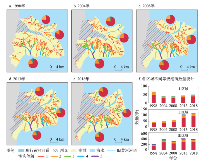
3.1.1 潮沟等级和数量 潮沟等级能够定量地表示潮沟系统的形态特征,潮沟系统等级越高,潮沟发育程度越高,对应的集水区面积越大,潮量越大[36]。潮沟数量符合Horton定义的关于河流数目的法则:随河流等级升高,对应的河流数目呈幂指数递减[34]。据Horton-Strahler分级原则,黄河三角洲潮沟系统的等级以1级、2级潮沟为主,约占潮沟总数93%,III区发育了5级最高等级潮沟(图3)。图3
 新窗口打开|下载原图ZIP|生成PPT
图3研究区各等级潮沟分布及各年份各区域不同等级潮沟数量统计
Fig. 3Distribution of various levels of tidal creeks in the study area and statistics of different levels of tidal creeks in each area in each year
潮沟等级及数量具有明显的时空异质性。如图3所示,1998—2004年Ⅰ区域各等级潮沟数量大量减少,2004—2018年缓慢增加。主要原因可能是黄河改道导致潮沟大量减少[37];调水调沙后Ⅰ区域潮沟恢复较为稳定的缓慢发育状态。Ⅱ区域在1998—2004年1级潮沟数量有所下降,2004年后各等级潮沟数量不断增加。主要原因是在改道初期大量淤泥阻塞导致低等级潮沟淤塞,使潮沟数量减少;在进行调水调沙实验后,潮沟数量明显增加,并且由于黄河入海口的改变,Ⅱ区域不断淤进,能够发育更多的潮沟,潮沟数量也在不断增加。Ⅲ区域各等级潮沟数量不断增加,潮沟等级为研究区最大,因为在黄河改道后,失去了黄河入海口泥沙补给[38],潮滩不断被海水侵蚀、冲刷,使潮沟网络不断发育。在2004—2008年期间,低等级潮沟数量减小,主要原因是湿地工程围垦了大面积潮滩[31, 38],导致大量低等级的潮沟被截断、淤积逐渐消亡。
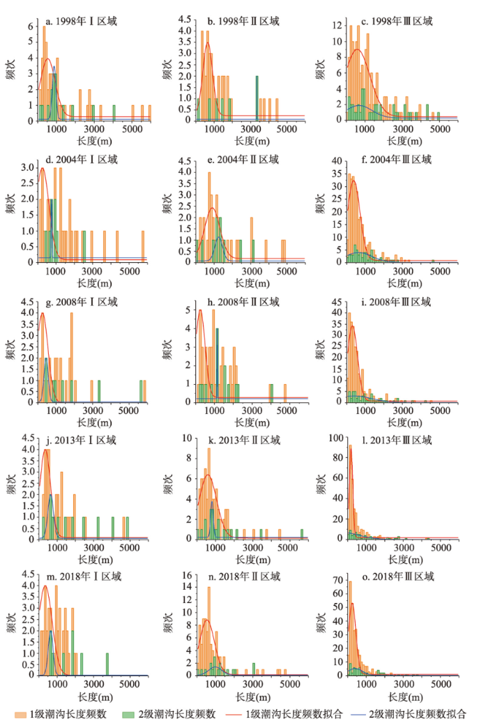
3.1.2 潮沟长度 一般而言,低阶潮沟系统的数量较多、长度较短、结构简单,高阶潮沟系统比较复杂,虽然数量较少,但长度较长。在整个研究区内有近80%的潮沟系统属于1~2级,而长度却占整个潮沟系统的30%。相反,3~5级潮沟系统的数量仅占总量的20%,但其总长度却占潮沟系统总长度的70%。在图3中可以看出,Ⅰ区域潮滩以1~2级潮沟系统为主,并且1~2级潮沟长度较长。
为探究潮沟等级与长度间的定量关系,将3个区域的潮沟进行拟合,由于高阶潮沟数量有限,仅拟合了1级和2级潮沟,长度频率趋于正态分布。3个区域的不同等级潮沟长度特征相似,在图4中可以看出,Ⅰ区域、Ⅱ区域的1级和2级潮沟长度比Ⅲ区域长。主要原因可能是Ⅰ区域潮沟处于基本稳定状态,Ⅱ区域由于互花米草的固滩作用,使潮沟不同等级间的转化速度降低[39],而Ⅲ区域潮沟快速发育,潮沟不断由低等级向高等级转化,同时支潮沟增加对滩面落潮水量的吸收使汇流面积缩小,较高等级的潮沟向低等级退化[39],不同等级潮沟之间的转化频率较高,导致低级潮沟无法延伸,长度较短。
图4
 新窗口打开|下载原图ZIP|生成PPT
图4不同分区不同级数潮沟长度频数图
Fig. 4Frequency diagram of tidal creek length in different districts and levels; red and green lines are fitting curves for first- and second-level creeks, respectively
3.1.3 潮沟密度 潮沟密度越大,潮沟的发育程度越高。Ⅰ区域的潮沟密度最小,Ⅱ区域次之,Ⅲ区域最大。Ⅰ区域在黄河改道后潮沟大幅度减少[37],导致潮沟密度降低,在2008年后潮沟密度基本不变,潮沟系统发育程度较低但较稳定。Ⅱ区域在2004年后潮沟密度增大,2013—2018年互花米草扩张阶段,潮沟密度有所增加(图5)。主要原因2002年调水、调沙实验后,黄河下游淤积的河道被冲刷开,潮沟数量异常增加[37],使潮沟密度增大;互花米草扩张增加了下垫面粗糙度,提高了归槽水位,在落潮时有更多的潮水需要排出[9],因此潮沟数量增大,潮沟密度也随之增大,即互花米草扩展促进了潮沟的发育。Ⅲ区域在黄河改道后失去沙源补给,并且由于潮水的不断冲刷,潮滩面积减少,潮沟快速发育,使得潮沟密度较大;湿地恢复围垦大面积潮滩,并且截断了上游潮沟,导致潮沟无法继续向上延伸,为了保持潮滩总体均衡性,潮沟系统要对自身形态做出调整,不断摆动、侧向发育,使潮沟密度增加。在2008年后围垦区面积基本不再增加,潮沟系统发育速度减缓,潮沟密度缓慢增长,处于较稳定阶段。
图5
 新窗口打开|下载原图ZIP|生成PPT
图5研究区潮沟核密度及分区域潮沟密度统计
Fig. 5Kernel density of tidal creek in the study area and statistics of tidal creek density by area
3.1.4 潮沟曲率 潮沟曲率越高,弯曲程度越大,蜿蜒性越强。黄河改道后初期,研究区潮沟的弯曲度整体较小,潮沟发育程度较低。根据图6可以看出,Ⅰ区域潮沟曲率较大,这是由于该区域受海水侵蚀程度最小[39]。Ⅱ区域的潮沟曲率整体较高(图6f),主要原因与该区域为黄河入海口,有沙源补给,潮滩由蚀退转变为淤进,受海洋动力影响减小有关,并且潮沟曲率在互花米草快速扩张期快速增大,说明互花米草扩张在一定程度上促进了潮沟的曲流发育。Ⅲ区域靠近湿地恢复区的潮沟曲率较大,这是由于湿地恢复截断了潮沟向上发育的通道,为了保持潮沟系统的均衡性,潮沟被迫改变自身形态,增大曲率以维持其排水效率,因此,大规模潮滩围垦活动对潮沟曲流发育具有一定促进作用。而该区域沿海部分在涨落潮时潮水不断冲刷潮沟,水动力较强[10],使潮沟比较顺直,并且,当潮沟弯曲度达到一定程度后,遇到暴雨、风暴潮等天气,潮沟内水量骤然增加,弯曲沟段将加快裁弯取直的速度[40],这也说明较强的海洋动力对潮沟曲流发育具有抑制作用。
图6
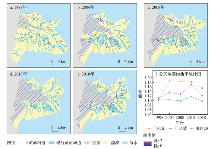 新窗口打开|下载原图ZIP|生成PPT
图6研究区潮沟曲率和分区域潮沟曲率统计
Fig. 6Curvature of tidal creek in the study area and statistics of tidal creek curvature by area
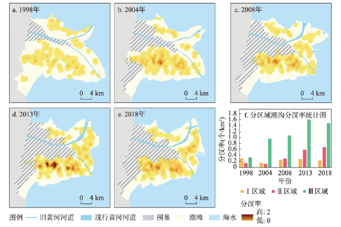
3.1.5 潮沟分汊率 潮沟分汊率越大,发育程度越高。Ⅰ区域分汊率较小且较为稳定,Ⅱ区域在互花米草快速扩张期分汊率增大,Ⅲ区域分汊率最大。在2004年湿地恢复初期,Ⅰ区域现行入海口处泥沙淤积使潮滩面积增加,潮沟发育程度较低,使潮沟分汊率下降(图7a、7b);到2008年湿地恢复后期,由于湿地恢复使潮滩面积减小,潮沟继续发育,使得分汊率提高(图7b、7c)。2013—2018年Ⅱ区域生长了大量互花米草,在一定程度上促进了潮沟分汊发育,潮沟发育程度增强。在1998—2004年,Ⅲ区域由于湿地恢复和潮水的侵蚀作用使潮滩面积减少,潮沟快速发育,数量增加,使潮沟分汊率显著提高;湿地恢复后潮沟分汊率不断增加至较稳定状态。在黄河改道,海水侵蚀,潮滩围垦活动和互花米草扩张的综合影响下,潮沟分汊率的变化特征与潮沟密度的变化趋势基本一致。
图7
 新窗口打开|下载原图ZIP|生成PPT
图7研究区潮沟分汊点分布及分区域潮沟分汊率统计
Fig. 7Distribution of tidal creek branch points in the study area and statistics of tidal creek bifurcation ratio by area
3.2 潮沟网络的排水效率及发育过程分析
3.2.1 潮沟网络的排水效率与形态特征参数的相关性分析 平均归槽长度(OPL)越短,排水效率越高,潮沟系统发育程度越高。潮沟系统的平均归槽长度与潮沟形态特征存在一定的相关性。将每个集水区的平均归槽长度与潮沟形态特征进行相关性分析。OPL与潮沟密度、曲率及分汊率的相关性分别约为-0.82、0.37和-0.78。OPL与潮沟密度有较强的相关性,即OPL值越小,潮沟系统密度越大,潮沟系统排水效率越高。OPL与分汊率的相关性也比较高,与潮沟平均曲率表现出较弱的相关性。Ⅰ区域受改道影响,潮沟大量减少,潮沟系统平均归槽长度增大,排水效率降低,潮沟发育程度较低。2004—2008年在调水、调沙实验后潮沟快速发育,密度增加,分汊率增加,潮沟系统平均归槽长度减小,排水效率增大。在2008年后潮沟发育基本稳定,泥沙淤积使潮滩面积增大,潮沟密度略有降低,潮沟系统平均归槽长度增大。2013年后,随着互花米草的扩张,潮沟密度增加,潮沟系统平均归槽长度略有降低,排水效率增大,潮沟发育程度基本稳定。
Ⅱ区域在2006年建成了侧弯丁坝,使丁坝南北两侧潮沟排水效率发生较大差异(图8f)。由于黄河改道在Ⅱ区域处形成新的入海口,泥沙大量淤积,潮滩面积增大,潮沟密度降低,因此,2004年潮沟系统平均归槽长度增大,排水效率降低。在2006年侧弯丁坝建成后,原本应随着潮流运移到南侧的泥沙被拦截,大量淤积在丁坝北侧[41],使北侧海岸线向海延伸,潮滩面积增大,潮沟系统平均归槽长度增大;但随着互花米草的快速扩增,所需排水效率较大,增大了潮沟密度,使潮沟系统平均归槽长度不断降低。侧弯丁坝南侧潮滩被海水蚀退,潮滩面积缩小,并且在海水的侵蚀作用下潮沟系统快速发育,密度逐渐增大,平均归槽长度减小,排水效率增大。
图8
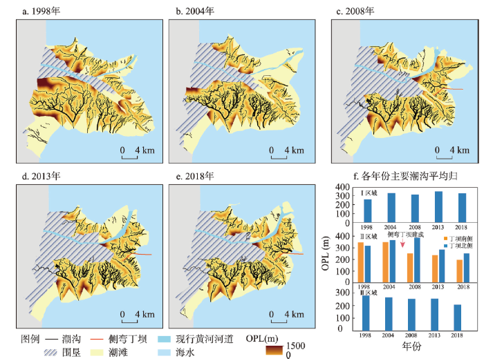 新窗口打开|下载原图ZIP|生成PPT
图8主要潮沟平均归槽长度和各年份主要潮沟平均归槽长度统计
Fig. 8Overmarsh path length of main tidal creek systems and overmarsh path length statistics of main tidal creek networks
Ⅲ区域平均归槽长度稳步降低,其原因主要是黄河改道后,原本泥沙淤进的潮滩逐渐被海水蚀退,并且湿地恢复工程使原本距离潮沟较远的滩面被围垦,随着潮沟的不断发育,潮沟密度不断增加,平均归槽长度不断减小,排水效率增强,潮沟系统发育程度较高。
3.2.2 潮沟发育过程的阶段性 黄河三角洲研究区不同区域受到的自然、人类影响均不相同,各区域潮沟系统的活跃程度和形态特征存在显著差异性。潮沟自形成至消亡没有明确的时间段,潮沟系统向平衡状态发展的过程可能需要4~13年的时间[7]。根据Steel和Pye提出的演化模型[20],结合潮沟各项形态参数和排水效率,分析各区域潮沟系统所处的发育阶段。
黄河改道明显改变了潮滩的水动力条件。1998—2004年处于黄河改道初期,Ⅰ区域受改道影响,潮沟数量大量减少,各项形态参数基本降低,排水效率降低,此时Ⅰ区域处于潮沟发育的幼年期,潮沟系统开始重新发育。Ⅱ区域成为新的黄河入海口,泥沙淤积使潮沟密度降低,植被面积基本不变,排水效率降低,潮沟系统开始发育,该区域处于幼年期。Ⅲ区域原入海口失去沙源补给,受潮水侵蚀影响最大,并且处于湿地恢复初期,大面积的潮滩被围垦,阻断了潮沟向上发展的通道,使潮沟系统非常活跃,各项形态参数增大,排水效率大幅提高,潮沟系统发育程度较高,因此潮沟系统处于青年期。
在2004—2008年湿地恢复前期,Ⅰ区域各项形态参数基本增大,潮沟排水效率提高,并且在2008年发现互花米草开始定植,潮沟快速发育,此时潮沟系统处于青年期。2002年首次对黄河进行调水、调沙试验,缓解了下游泥沙淤积状况,促进了Ⅱ区域潮沟的发育演化。并且现行黄河入海口处泥沙淤积,使潮沟位置发生剧烈变化,加之互花米草开始定植,潮沟快速发育,各项形态参数增大,排水效率增大,潮沟系统处于青年期。Ⅲ区域在这一期间潮滩围垦面积达到最大,潮沟摆动最为剧烈,分汊率、密度增大,潮沟上游曲率增加,排水效率持续增加,此时潮沟系统仍处于青年期。
在2008—2013年湿地恢复后期,Ⅰ区域潮沟数量缓慢增长,各项形态参数都较为稳定,排水效率略有提高,潮沟发育放缓,潮沟系统处于中年期。Ⅱ区域各项形态参数快速增加,排水效率增大,潮沟系统仍处于青年期。Ⅲ区域湿地恢复基本结束,湿地恢复截断潮沟向上发育通道,但通过发育出细小的低级潮沟来弥补潮沟的损失,以维持潮滩的均衡性,潮沟系统的活动性明显降低,各项形态参数处于较为稳定的增长状态,排水效率提高,此时潮沟系统处于中年期。
图9
 新窗口打开|下载原图ZIP|生成PPT
图9研究区植被分布变化和分区域植被面积统计
Fig. 9Changes in vegetation distribution in the study area and statistics of vegetation area by area
2013—2018年互花米草扩增期,Ⅰ区域各项形态参数较为稳定,排水效率略有增加,潮沟系统处于中年期。这一时期为互花米草扩增期,Ⅱ区域入海口处互花米草面积迅速增加,使潮滩水动力明显减弱[42],增加潮沟的曲折发育,并且增大下垫面糙度,使互花米草盐沼潮滩落潮时的归槽水位增高,因此排水效率提高。此时该区域处于中年期,潮沟发育放缓。Ⅲ区域除潮沟密度外其他形态参数均有所降低,排水效率维持较稳定的增长状态,潮沟发育速度放缓,处于平衡状态,此时潮沟系统仍处于中年期。但Ⅲ区域植被逐渐发育增多,在植被的快速定植作用下,该区域有可能出现潮沟系统发展阶段逆转现象,再次迎来潮沟活跃性较高的青年期。
4 讨论与结论
4.1 讨论
本次实验探究了大范围、长时序的潮沟网络的形态特征及其在不同海洋动力、人类活动和植被影响等条件下的发育过程。与黄河三角洲类似,长江三角洲的九段沙与崇明岛、江苏中部沿海等区域的潮沟发育过程都受到海洋动力、植被和人类活动的影响[10, 43]。潮流受滩面高程梯度控制产生对滩面的冲刷,在潮沟的发育中起到重要作用[44],新产生的潮沟在溯源侵蚀影响下快速延伸,并且由于潮流流速增大而变宽变深[22]。1996年黄河改道后,Ⅰ区域和Ⅱ区域仍受到海水微侵蚀影响,潮沟形态特征变化幅度较大。海水侵蚀成为Ⅲ区域的主旋律,Ⅲ区域潮沟数量、密度和分汊率大幅增加,表明海水侵蚀对潮沟形态特征的变化起到推动作用,促进了潮沟的快速发育。2008年后,由于上游黄河泥沙补给和互花米草扩张带来的固滩作用,Ⅰ区域和Ⅱ区域侧弯丁坝北部由微侵蚀转化为纯淤积,受海洋动力影响程度达到最小。而Ⅲ区域由于黄河改道和丁坝的建设导致泥沙供给不足,流域来水来沙减少和海水侵蚀等影响导致潮滩面积减少[45,46]。虽然Ⅲ区域受海洋动力影响最大,但其潮沟形态特征变化开始放缓,潮沟数量、密度、分汊率变化幅度较小。这可能是因为潮滩面积缩小,流水冲刷作用减弱,单纯依靠侵蚀无法进一步推动潮沟形态特征的变化,潮沟的形态特征逐渐趋于稳定[22],达到一种均衡状态[47]。
目前研究区植被主要聚集在Ⅰ、Ⅱ区域,Ⅲ区域以泥滩为主,植被零星分布,以碱蓬为主。河口泥沙淤积,有适宜的盐分、水分及养分,为Ⅰ、Ⅱ区域盐沼植被提供了良好的定植条件[15],而植物可以稳固潮沟的两岸,促使潮沟系统不断发展[17, 48]。在互花米草快速扩张期,Ⅱ区域潮沟曲率、密度、分汊率大幅增加,互花米草的扩张促进了潮沟的蜿蜒发育,潮沟分汊增多,增大潮沟的排水效率。这与沈永明等[9]进行一年间野外测量所得结果相同。到互花米草缓慢扩张期,潮沟密度、分汊率等形态特征变化幅度放缓,此时在高而浓密的互花米草带,植被成为制约潮沟继续发育的重要因子[43],但尚未达到陈勇等[49]在长江口崇明东滩所发现的植被发育的地方往往潮沟密度较小的情况。根据卫星遥感影像发现,Ⅲ区域在2018年已经初步出现互花米草的扩张[15],植被分布已经呈现出从Ⅲ区域潮滩边缘向潮滩中心扩张的趋势,考虑到互花米草的强大定植能力和快速扩张趋势[50,51],Ⅲ区域日后可能会向盐沼区域转变,潮沟可能再一次大幅度变化。
人类活动对潮沟发育过程产生极大的影响。与黄河三角洲围垦区恢复湿地不同,长江三角洲围垦主要目的为固滩[52],江苏中部沿海主要目的为发展耕地和养殖[53]。2004—2008年期间,黄河三角洲由于湿地恢复围垦大面积潮滩,截断了上游潮沟,潮沟被迫改变自身形态,增大潮沟曲率、密度以维持其排水效率,因此研究区内大规模潮滩围垦活动对潮沟曲流发育具有一定促进作用。并且原本距离潮沟较远的滩面被围垦,平均归槽长度减小,排水效率增强,潮沟密度增加,潮沟系统发育程度增强。与吴德力等在江苏中部的研究类似,潮滩围垦活动使低级潮沟长度减小[10],而中潮带区域潮沟密度增大。在长江口崇明东滩以固滩为目的的大规模围垦活动使东北部位的潮沟系统逐渐消亡[52]。黄河三角洲侧弯丁坝的建成使丁坝南北两侧潮沟网络发育产生差异,丁坝的建设导致泥沙被拦截[54],丁坝北侧泥沙淤积[41],排水效率降低,直到互花米草快速扩张期排水效率逐步增大。丁坝南侧泥沙被拦截,潮滩受海水侵蚀影响不断蚀退[43, 49],发育出更多潮沟,排水效率增大。黄河三角洲在人类活动过程中,潮沟发育程度Ⅲ区域最大、Ⅱ区域次之、Ⅰ区域最小的总体趋势没有发生改变,黄河南岸以侵蚀为主的趋势也没有改变,而长江口九段沙顶端从深水巷道工程前的微弱冲刷变为强烈淤长[55],改变了潮沟发育的重要水动力条件,使南北两岸潮沟发育产生差异。因此长江三角洲潮沟的发育受人类活动的影响较黄河三角洲地区大。
4.2 结论
在遥感图像数字处理和地理空间信息技术支持下,本文从黄河三角洲湿地恢复工程、侧弯丁坝建设等重要的人类活动事件出发,结合互花米草的入侵过程及海洋动力的影响,定量分析潮沟形态特征的时空异质性,深入探讨潮沟的发育过程及阶段性特征。主要结论如下:① 黄河三角洲研究区内潮沟形态具有明显的南北区域差异。Ⅲ区域潮沟发育程度最大,其次是Ⅱ区域,Ⅰ区域潮沟发育程度最低。潮沟数量、密度、分汊率呈现增长趋势,但增长趋势逐渐放缓。由于海水侵蚀和植被扩张的综合影响,Ⅰ区域和Ⅱ区域的一、二级潮沟长度比Ⅲ区域长。靠向陆地一侧的潮沟曲率大于临海侧。平均归槽长度与潮沟密度和分汊率相关性较大。② 潮沟的形态特征与海洋动力、植被发育、人类活动息息相关。在经历前期潮沟系统快速变化后,目前3个区域均处于中年期,潮沟整体进入缓慢变化状态,其发育状态趋向于动态平衡。参考文献 原文顺序
文献年度倒序
文中引用次数倒序
被引期刊影响因子
[本文引用: 1]
[本文引用: 1]
DOI:10.2307/1941822URL [本文引用: 1]
DOI:10.11821/xb199704009 [本文引用: 1]

1. The estuary can generally be divided into three sections. (1) Near mouth section: Its upper boundary is the tidal influence limit in the flood season, and the lower boundary is the limit between fresh water and brackish water (with salinity 0 1‰) in the dry season. This section is controlled by the fresh water and not influenced by diluted water (or mixed water) going upstream, which represents the runoff predominance. (2) River mouth section: Its upper boundary is the limit between the fresh water and brakish water in the dry season, and the lower boundary is at the place where there is the salt water with salinity about 30‰ in the bottom layer during flood season. It is the intruding front of the salt water (or continental water) during flood season where exists mixing and interaction of salt and fresh waters, with reciprocal tidal current. (3) Mouth outside seashore: Its bottom layer is controlled by salt water or continental water, and surface layer is covered by the diluted water (or mixed water), where the movement of tidal current is characterized by the rotation. 2. Accoding to the relative intensity of the influences of the river, tide or wave, the estuaries can be divided into three basic classes: river dominated, tide dominated and wave dominated. Their chief characteristics of dynamics, sedmentations and geomorphologies are also discussed in this paper. 3. The function of estuarine system can possibly be accommodated and satisfied by the input, transfer and output of informations and energies from river and sea, which is activated by continuous adjustment of the system′s elements, such as density ( ρ ), depth of the limit of salt and fresh water ( h′ ), velocity ( U ), slope of water surface ( J ), water depth ( H ), width ( B ) and sediment composition ( D ), and a specific optimized form of the estuary is established. The automatic adjustment of estuary is subordinated to the general rules in the alluvial river processes, including: (1) having balance tendency; (2) making initial energy of the system tend to redistribute in some rules; (3) integrating the adjustment processes, that is, the element of the system are influenced with each other and response as a whole; (4) having feedback of automat. For satisfying a transformation from river to sea or from sea to river, the estuary should modulate and transform by mixing salt and fresh water. However, because different estuarine types have their own predominant dynamic conditions, the estuarine system should draw supports from other regimes to do the automatic adjustment in order to maintain the balance. The characteristics of automatic adjustment for the three classes of estuaries are discussed in this paper.
[本文引用: 1]
[本文引用: 1]
[本文引用: 1]
[本文引用: 4]
DOI:10.1046/j.1526-100X.2002.t01-1-02035.xURL [本文引用: 2]
[本文引用: 2]
[本文引用: 2]
[本文引用: 3]
[本文引用: 3]
[本文引用: 5]
This paper details the two-dimensional geomorphology of the tidal creek systems and their migration characteristics using MSS, TM/ETM + data of 1981-2010 and field investigation. The results show that the tidal creeks in this area could be divided into four grades according to their lengths: 7587±1544 m, 1921±916 m and 327±200 m with numbers of 21, 97 and 688 (1:5:33), respectively. The tidal creeks within the study area were well developed in the middle tidal belt, and their drainage density and bifurcation ratio were much greater than those in the high and low tidal belts. The curvature of main tidal creek decreased from high tidal belt to the low one. The development of tidal creeks are influenced by the exotic introduction of <em>Spartina alterniflora</em>, and obviously restrained by the reclamation activities. The lateral migration or sway of the tidal creeks exhibited significant difference in rank and region. Compared with the tidal creek systems in the northern part of the area studied, those in the southern part with a larger tidal range have a larger lateral movement ranges and migration rates; as for a tidal creek system, the sway intensity of a first-order creek is greater than that of a second-order creek, followed by a third-order creek; for a single tidal creek, the case is the lower segment > the middle segment > the upper segment; and within an individual segment, the migration intensity of the curving segment is greater than that of the straight segment. The lateral migration is not obvious in the upper segment of the first-order creeks, the middle and upper segment of the second-order creeks, the third-order creeks and the creeks in the S.<em> alterniflora salt-marsh</em>.
[本文引用: 5]
URL [本文引用: 1]
[本文引用: 1]
[本文引用: 1]
[本文引用: 1]
[本文引用: 1]
DOI:10.1002/ldr.v32.3URL [本文引用: 3]
[本文引用: 4]
[本文引用: 4]
[本文引用: 1]
URL [本文引用: 2]
DOI:10.5194/esurf-2-105-2014URL [本文引用: 1]
DOI:10.1002/esp.v38.2URL [本文引用: 1]
[本文引用: 2]
[D].
[本文引用: 1]
[D].
[本文引用: 1]
DOI:10.1016/j.csr.2009.08.018URL [本文引用: 3]
DOI:10.1002/esp.2099URL [本文引用: 1]
DOI:10.1016/j.rse.2017.11.012URL [本文引用: 3]
[本文引用: 1]
[本文引用: 1]
[本文引用: 1]
[本文引用: 1]
DOI:10.13287/j.1001-9332.201909.019PMID:31529885 [本文引用: 1]
The Yellow River Delta exhibits irregular tidal flat, with tidal creeks that vary in width and experience tidal creek current anisotropy. Given such characteristics, the GF-2 multi-spectral image was selected as the data source to characterize the details of tidal creeks. First, the normali-zed difference water index (NDWI) and OTSU classification were used to delineate the wide tidal creeks. Second, the modified fuzzy C-means clustering algorithm (MFCM) and multi-scale Gaussian matching filter (MGMF) were used to enhance the narrow tidal creeks on the basis of weakening the heterogeneity of tidal flat background. Then, the adaptive threshold segmentation was conducted to delineate the narrow tidal creeks. Finally, the complete tidal creek networks were delineated by combining the wide and narrow tidal creeks. We fully used the spatial resolution and spectral information of the GF-2 image and took into account the geometric features of the linear features, ensuring the spatial continuity of the tidal creek extraction results. In the four tested areas, the Kappa coefficient was greater than 0.8 and the overall accuracy was greater than 97%, which performed better than the maximum likelihood method and support vector machine. The results showed that the proposed method could completely differentiate different types of tidal creeks, with good extraction accuracy and stability. The method could provide scientific reference for real-time dynamic monitoring of tidal creek and its development and evolution.
PMID:31529885 [本文引用: 1]
DOI:10.1080/01431161.2019.1707898URL [本文引用: 3]
DOI:10.31497/zrzyxb.20191207URL [本文引用: 1]
[本文引用: 1]
DOI:10.1007/s13157-020-01292-7URL [本文引用: 1]
[本文引用: 2]
[本文引用: 2]
[本文引用: 1]
[本文引用: 1]
DOI:10.1029/93WR02279URL [本文引用: 1]
[本文引用: 2]
DOI:10.1080/01431160500206692URL [本文引用: 1]
[本文引用: 1]
[本文引用: 3]
[本文引用: 3]
[本文引用: 2]
[本文引用: 2]
URL [本文引用: 3]
[本文引用: 1]
[本文引用: 1]
URL [本文引用: 2]
[本文引用: 1]
[本文引用: 1]
[本文引用: 3]
[本文引用: 3]
[本文引用: 1]
URL [本文引用: 1]
DOI:10.1038/s41586-018-0805-8URL [本文引用: 1]
DOI:10.1002/(ISSN)1096-9837URL [本文引用: 1]
DOI:10.1016/j.geomorph.2014.01.002URL [本文引用: 1]
[本文引用: 2]
[本文引用: 2]
DOI:10.1002/2013JF002900URL [本文引用: 1]
URL [本文引用: 1]
[本文引用: 2]
[本文引用: 2]
DOI:10.11821/dlxb201501002 [本文引用: 1]
Five remote sensing images (1977, 1984, 2000, 2007 and 2014) were obtained to study the spatial dynamics of coastal wetlands and reclamation area in central Jiangsu province. The results indicated that most of the coastal wetlands showed an accretion trend from the south of Sheyang estuary, while there still existed some erosion phenomena in the past 40 years. The mean rate of accretion/erosion of Jiangsu coastal wetlands was ±20 m per year, and the highest value was observed at Dongtai and Yangkou ports. Meanwhile, the reclamation rate was significantly higher than the accretion ones, and the former kept a level of 50 m per year. In addition, the key ecological areas of Jiangsu coastal wetlands reduced rapidly from 1977 to 2014, which can be found from the shrinkage of natural halophytic vegetation in the southern part of Sheyang County and the whole part of Dafeng County. It was found in field surveys that the evolution pattern of reclamation in coastal wetlands was in the order of bare flat → halophytic vegetation → aquaculture pond → cropland → built-up land. However, with the aid of new technology, the period of evolution pattern was shortened. Moreover, the development of coastal wetlands has been intensified due to reclamation activities. The hotspots of reclamation were presented at major ports and central towns.
[本文引用: 1]
DOI:10.1007/s11625-008-0043-3URL [本文引用: 1]
[本文引用: 1]
[本文引用: 1]
