Abstract Sand seas and semi-arid dune fields, an important component of the earth environmental system, is sensitive to global climate change. Meanwhile, environmental changes in sand seas and dune fields influence regional sustainability, and can also affect regional climate and global environment through feedbacks of different scales. The Mu Us Sandy Land, located in the north-central part of China, is one of the typical semi-arid dune fields in the middle latitude. Its aeolian environmental change during the past is comparable and synchronous with some other sand seas and dune fields around the world. The study of aeolian environmental change in the Mu Us Sandy Land has a long history in China. This paper reviews and summarizes the theory and new findings in the study of processes and mechanisms of aeolian environmental change in the Mu Us Sandy Land. Important progresses have been made in recent decades focusing on the late Cenozoic evolution of the study area, its late Quaternary expansion and polycyclic changes, and dune field stabilization during the middle Holocene and dune reactivation since the late Holocene. Key sedimentary evidence has been found to support these new findings, and new theories about dune field evolution at the tectonic and orbital scales in response to global temperature change and nonlinear response of dune systems at millennial and centennial scales have been proposed. In the future, by collecting more crucial sedimentary evidence, the application of state-of-art technique, fine-scale and process-informed paleoenvironmental reconstruction, and numerical modeling and projection studies, our understanding can be significantly improved about the dynamical mechanisms of aeolian environmental change, the coupling of human-environment complex system in the drylands, and the processes and feedbacks in the Earth surface environmental system. This will also have great significance for the development in the field of physical geography, integration of interdisciplinary studies, and theory exploration of the Earth System Science. Keywords:aeolian activity;geomorphological processes;environmental reconstruction;climate change;dryland;Mu Us Sandy Land
PDF (5069KB)元数据多维度评价相关文章导出EndNote|Ris|Bibtex收藏本文 本文引用格式 徐志伟, 鹿化煜. 毛乌素沙地风沙环境变化研究的理论和新认识. 地理学报, 2021, 76(9): 2203-2223 doi:10.11821/dlxb202109012 XU Zhiwei, LU Huayu. Aeolian environmental change studies in the Mu Us Sandy Land, north-central China: Theory and recent progress. Acta Geographica Sinice, 2021, 76(9): 2203-2223 doi:10.11821/dlxb202109012
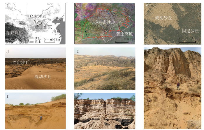
注:a. 地理位置;b. 区域卫星遥感影像图(白色虚线框表示沙地与黄土高原过渡带的大致位置,底图为GeoCover影像);c. 高分辨率遥感影像显示的流动沙丘与固定沙丘共存(底图来自Google Earth);d. 沙丘双稳态地貌景观;e. 沙地与黄土高原过渡带的地表覆沙景观;f.沙地内部大型沙丘开挖剖面中出露厚层风成沙和埋藏古土壤;g. 沙地东南部一处典型的河流—湖沼相沉积地层;h. 沙地与黄土高原过渡带黄土堆积中的厚层古风成沙(该层风成沙年代较老)。照片d~h分别拍摄于2019年7月、2010年4月、2011年5月、2012年5月和2010年5月。 Fig. 1The geographic location, landscape feature and typical stratigraphic sections of the Mu Us Sandy Land
注:郭家梁剖面数据来源于丁仲礼等[65],石峁剖面数据来源于孙继敏等[72]。 Fig. 2Aeolian environmental changes of the Mu Us Sandy Land during the late Cenozoic and late Quaternary revealed by sediment grain-size change from the typical aeolian deposits
注:a. 末次盛冰期的扩张边界;b. 全新世中期(大暖期)的固定。本图引自徐志伟博士学位论文[73],数据统计截至2014年12月,含部分未发表数据。图b中的虚线表示在全新世中期沙丘大部分被固定、流沙面积大幅度减少,虚线和箭头示意有流动沙丘广泛分布的活跃沙漠处于更加西北的位置。 Fig. 3Expansion of the Mu Us Sandy Land during the LGM and its stabilization during the middle Holocene
注:a. LP03剖面,毛乌素沙地与黄土高原过渡带埋藏古风成沙及黄土古土壤沉积;b. MU11-42剖面,毛乌素沙地内部风成沙—古土壤互层沉积;数据引自[20, 34]。 Fig. 4Typical sedimentary sections recording aeolian environmental change in the Mu Us Sandy Landduring the past 20 ka and the OSL dating results
注:本图引自[73],数据统计截至2014年12月,含部分未发表数据。沙地外围主要指毛乌素沙地与黄土高原的过渡带。 Fig. 5Frequency distribution of the ages of the aeolian sand and paleosol from the Mu Us Sandy Land
注:本图改自文献[34]; 图a不同的行列或短杠表示不同点位沙丘的状态及转换特征,在同一时间窗口内,流动沙丘和固定沙丘可以同时存在,在过去12 ka内不同点位沙丘状态的转换存在显著差异;图b蓝色实线代表在不同外部环境条件下的沙丘稳定状态(或称稳定平衡线),蓝色虚线为不稳定状态,在一定的外部环境条件(如②、③、④)存在双稳态,处于其他状态的沙丘会朝向稳定状态演化,F1和F2为分岔点(Tipping Points),沙丘从一种稳定状态转变到另一种稳定状态时(如红色虚线所示),称为稳态转换,“山谷中的小球”示意在不同的外部环境条件下沙丘所处的吸引域,其大小可以表征沙丘被扰动后的恢复力,其中在②、③、④条件下存在2个吸引域,代表2种稳定状态,随着外部环境条件的改变或者受到强的干扰(如红色实线所示),沙丘会发生稳态转换,沙丘在临界点上的稳态转换往往表现为突变。 Fig. 6Temporal pattern of the shifts in dune activity during the Holocene at individual sites from the Mu Us Sandy Land and theoretical model for dune bistability
Reynolds JF, Smith DM, Lambin EF, et al. Global desertification: Building a science for dryland development Science, 2007, 316(5826): 847-851. PMID:17495163 [本文引用: 1] In this millennium, global drylands face a myriad of problems that present tough research, management, and policy challenges. Recent advances in dryland development, however, together with the integrative approaches of global change and sustainability science, suggest that concerns about land degradation, poverty, safeguarding biodiversity, and protecting the culture of 2.5 billion people can be confronted with renewed optimism. We review recent lessons about the functioning of dryland ecosystems and the livelihood systems of their human residents and introduce a new synthetic framework, the Drylands Development Paradigm (DDP). The DDP, supported by a growing and well-documented set of tools for policy and management action, helps navigate the inherent complexity of desertification and dryland development, identifying and synthesizing those factors important to research, management, and policy communities.
SarntheinM. Sand deserts during glacial maximum and climatic optimum Nature, 1978, 272(5648): 43-46. DOI:10.1038/272043a0URL [本文引用: 2]
DongGuangrong. Study on the Formation and Evolution of Deserts, Climate Change and Desertification in China. Beijing: China Ocean Press, 2002. [本文引用: 5]
LiY, KalnayE, MotesharreiS, et al. Climate model shows large-scale wind and solar farms in the Sahara increase rain and vegetation Science, 2018, 361(6406): 1019-1022. DOI:10.1126/science.aar5629URL [本文引用: 1]
Abell JT, PullenA, LeboZ, et al. A wind-albedo-wind feedback driven by landscape evolution Nature Communications, 2020, 11(1): 96. DOI: 10.1038/s41467-019-13661-w. URL [本文引用: 1]
MahowaldN. Aerosol indirect effect on biogeochemical cycles and climate Science, 2011, 334(6057): 794-796. DOI:10.1126/science.1207374PMID:22076375 [本文引用: 1] The net effect of anthropogenic aerosols on climate is usually considered the sum of the direct radiative effect of anthropogenic aerosols, plus the indirect effect of these aerosols through aerosol-cloud interactions. However, an additional impact of aerosols on a longer time scale is their indirect effect on climate through biogeochemical feedbacks, largely due to changes in the atmospheric concentration of CO(2). Aerosols can affect land and ocean biogeochemical cycles by physical forcing or by adding nutrients and pollutants to ecosystems. The net biogeochemical effect of aerosols is estimated to be equivalent to a radiative forcing of -0.5 ± 0.4 watts per square meter, which suggests that reaching lower carbon targets will be even costlier than previously estimated.
Huang JP, LiY, Fu CB, et al. Dryland climate change: Recent progress and challenges Reviews of Geophysics, 2017, 55(3): 719-778. DOI:10.1002/rog.v55.3URL [本文引用: 1]
Chadwick OA, Derry LA, Vitousek PM, et al. Changing sources of nutrients during four million years of ecosystem development Nature, 1999, 397(6719): 491-497. DOI:10.1038/17276URL [本文引用: 1]
Bishop JK, Davis RE, Sherman JT. Robotic observations of dust storm enhancement of carbon biomass in the North Pacific Science, 2002, 298(5594): 817-821. PMID:12399588 [本文引用: 1] Two autonomous robotic profiling floats deployed in the subarctic North Pacific on 10 April 2001 provided direct records of carbon biomass variability from surface to 1000 meters below surface at daily and diurnal time scales. Eight months of real-time data documented the marine biological response to natural events, including hydrographic changes, multiple storms, and the April 2001 dust event. High-frequency observations of upper ocean particulate organic carbon variability show a near doubling of biomass in the mixed layer over a 2-week period after the passage of a cloud of Gobi desert dust. The temporal evolution of particulate organic carbon enhancement and an increase in chlorophyll use efficiency after the dust storm suggest a biotic response to a natural iron fertilization by the dust.
Martin JH, Fitzwater SE. Iron deficiency limits phytoplankton growth in the north-east Pacific subarctic Nature, 1988, 331: 341-343. DOI:10.1038/331341a0URL [本文引用: 1]
Jickells TD, An ZS, Andersen KK, et al. Global iron connections between desert dust, ocean biogeochemistry, and climate Science, 2005, 308(5718): 67-71. PMID:15802595 [本文引用: 1] The environmental conditions of Earth, including the climate, are determined by physical, chemical, biological, and human interactions that transform and transport materials and energy. This is the "Earth system": a highly complex entity characterized by multiple nonlinear responses and thresholds, with linkages between disparate components. One important part of this system is the iron cycle, in which iron-containing soil dust is transported from land through the atmosphere to the oceans, affecting ocean biogeochemistry and hence having feedback effects on climate and dust production. Here we review the key components of this cycle, identifying critical uncertainties and priorities for future research.
Martínez-GarcíaA, Sigman DM, RenH, et al. Iron fertilization of the Subantarctic Ocean during the last ice age Science, 2014, 343(6177): 1347-1350. DOI:10.1126/science.1246848PMID:24653031 [本文引用: 1] John H. Martin, who discovered widespread iron limitation of ocean productivity, proposed that dust-borne iron fertilization of Southern Ocean phytoplankton caused the ice age reduction in atmospheric carbon dioxide (CO2). In a sediment core from the Subantarctic Atlantic, we measured foraminifera-bound nitrogen isotopes to reconstruct ice age nitrate consumption, burial fluxes of iron, and proxies for productivity. Peak glacial times and millennial cold events are characterized by increases in dust flux, productivity, and the degree of nitrate consumption; this combination is uniquely consistent with Subantarctic iron fertilization. The associated strengthening of the Southern Ocean's biological pump can explain the lowering of CO2 at the transition from mid-climate states to full ice age conditions as well as the millennial-scale CO2 oscillations.
ZhuZhenda, WuZheng, LiuShu, et al. An Introduction to the Deserts in China. Beijing: Science Press, 1974. [本文引用: 3]
Nie JS, StevensT, RittnerM, et al. Loess plateau storage of northeastern Tibetan Plateau-derived Yellow river sediment Nature Communications, 2015, 6: 8511. DOI: 10.1038/ncomms9511. URL [本文引用: 1]
Xu ZW, StevensT, Yi SW, et al. Seesaw pattern in dust accumulation on the Chinese Loess Plateau forced by late glacial shifts in the East Asian monsoon Geology, 2018, 46(10): 871-874. DOI:10.1130/G45105.1URL [本文引用: 10]
Department of Geography in Peking University, et al. The Natural Conditions of the Mu Us Dune Field and Its Improvement and Utilization. Beijing: Science Press, 1983. [本文引用: 2]
DongGuangrong, LiBaosheng, GaoShangyu, et al. The Quaternary ancient eolian sands in the Ordos Plateau Acta Geographica Sinica, 1983, 38(4): 341-347. DOI:10.11821/xb198304002 [本文引用: 5] The Ordos Plateau is the area where the Quaternary ancient eolian sands are well developed and they have been discontinuously discovered since very early time. The authors, after their recent investigations, have discovered that the Quaternary ancient eolian sands are distributed in varying depth in the studied area.According to the state of preservation, the ancient eolian sands can be classified into two types: the buried type and the relict type. The buried eolian sand is more complete and can be distinctly seen along the north margin of the loess plateau, especially the Yulin region of northern Shaanxi. The strata with ancient eolian sands can be divided into five groups in order from top to bottom: Holocene, Late Pleistocene, the upper and lower parts of the Mid Pleistocene and the Early Pleistocene series. They can be compared with the loess profile in Luochuan. The buried ancient eolian sand occurs in the loess strata as the intercalated bed of fine sand and sandy loam, including sandy Heilu loam and sandy brown soil, it does not spread continuously in the horizontal and longitudinal direction and constitute lit par lit depositional series with loess and silty loam. [董光荣, 李保生, 高尚玉, 等. 鄂尔多斯高原的第四纪古风成沙 地理学报, 1983, 38(4): 341-347.] [本文引用: 5]
DongGuangrong, LiBaosheng, GaoShangyu, et al. The discovery of Quaternary ancient eolian sands in the Ordos Plateau and its significance Chinese Science Bulletin, 1983, 16: 998-1001. [本文引用: 5]
DongGuangrong, GaoShangyu, LiBaosheng, et al. The phenomenon of fossil ice and its significance in climatic stratigraphy in the Ordos Plateau since the late Pleistocene Geographical Research, 1985, 4(1): 1-11. DOI:10.11821/yj1985010001 [本文引用: 2] At the present time two kinds of fossil ice margins have been found, con-gelifolds and fossils sand (loess) wedges in the strata of the studied area. The former is mainly found in the limnetic strata at the top of the Salawusu Group(Q<sub>3</sub><sup>1</sup>), The middle Chengchuan Group (Q<sub>3</sub><sup>2-2</sup>), The middle and the lower Dagouwan Group (Q<sub>4</sub><sup>3</sup>) and at the bottom of Dishaogouwan Group (Q<sub>4</sub><sup>3</sup>) along the Salawusu He in the southeastern depression Among them the middle Chengchuan Group is the largest and the widest.Besider, it can also be found in certain horizons along the wuding He, Lu He, Hailuitu He, yulin He and Salawusu He near the loess hilly areas. The latter is mainly presented in the Tertiary mud stone or red earth, in the lower-middle Pleistocene loess or the lower part of the late Pleistocene sand (earth) gravel layer and on the top of the middle Chengchuan Group in the central-western dry denuded upland and the flat and lower areas on the low ridge land of its extending part to the depression.According to the morphological characteristics of the profile, these folds and wedges had not any relation to the genesis of tectonic movement fluvial-erosion, accumulation, glacier, mudflow, hard press of landslide and drying crack of ground surface, but to the stratum deformation or disturbance caused by seasonal nonhomogeneous melting and freezing processes for a long time in the frozen eartn area.The big or medium type of nondeveloped congeli-folds (mainly situated in the upper late pleistocene strata) and sand (loess) wedges(situated in the middle and lower profile)were related to the seasonal process of the permafrost and the other congelifolds located in the middle and lower Holocene strata and the small type of sand (loess) wedges located in the upper profile might possibly be formed under the condition of the deep seasonal frozen earth and even the other year's frozen earth. [董光荣, 高尚玉, 李保生, 等. 鄂尔多斯高原晚更新世以来的古冰缘现象及其气候地层学意义 地理研究, 1985, 4(1): 1-11.] [本文引用: 2]
ShiPeijun. Theory and Practice of the Geographical Environmental Evolution Study: A Study on the Geographical Environmental Evolution in the Ordos Region since the Late Quaternary. Beijing: Science Press, 1991. [本文引用: 1]
SuZhizhu, DongGuangrong. Climatic change in the northern Shaanxi Loess Plateau during the last 130000 years Journal of Desert Research, 1994, 14(1): 45-51. [本文引用: 5]
LiBaosheng, JinHeling, LvHaiyan, et al. The deposition and evolution of the Mu Us Desert since the 150 ka Science in China (Series D), 1998, 28(1): 85-90. [本文引用: 3]
Zhou WJ, DodsonJ, Head MJ, et al. Environmental variability within the Chinese desert-loess transition zone over the last 20000 years The Holocene, 2002, 12(1): 107-112. DOI:10.1191/0959683602hl525rrURL [本文引用: 2]
LuRuijie, XiaHong, QiangMingrui, et al. Environmental evolution in past 130 years recorded by Bojianghaizi lake sediments in North Mu Us Desert, China Journal of Desert Research, 2008, 28(1): 44-49. [本文引用: 2]
Lu HY, Miao XD, Zhou YL, et al. Late Quaternary aeolian activity in the Mu Us and Otindag dune fields (north China) and lagged response to insolation forcing Geophysical Research Letters, 2005, 32(21): L21716. DOI: 10.1029/2005GL024560. URL [本文引用: 5]
Lu HY, Zhou YL, Liu WG, et al. Organic stable carbon isotopic composition reveals late Quaternary vegetation changes in the dune fields of northern China Quaternary Research, 2012, 77(3): 433-444. DOI:10.1016/j.yqres.2012.01.009URL [本文引用: 1]
Xu ZW, Lu HY, Yi SW, et al. Climate-driven changes to dune activity during the Last Glacial Maximum and deglaciation in the Mu Us field, north-central China Earth and Planetary Science Letters, 2015, 427: 149-159. DOI:10.1016/j.epsl.2015.07.002URL [本文引用: 9]
Xu ZW, Mason JA, XuC, et al. Critical transitions in Chinese dunes during the past 12000 years Science Advances, 2020, 6(9): eaay8020. DOI: 10.1126/sciadv.aay8020. [本文引用: 22]
DongGuangrong, ChenHuizhong, WangGuiyong, et al. The evolution of deserts and sandy lands in northern China and climate change during the past 150 ka Science in China (Series B), 1995, 25(12): 1303-1312. [本文引用: 2]
DingZhongli, SunJimin. Setpwise expansion of the Mu Us dune field since the Pliocene revealed by the sedimentary evidence of loess-red clay deposits Chinese Science Bulletin, 1999, 44(3): 324-326. [本文引用: 4]
GaoShangyu, WangGuiyong, HaSi, et al. A case study on desert evolution in the northwestern fringe of monsoon area, China since the last glacial epoch Quaternary Sciences, 2001, 21(1): 66-71. [本文引用: 1]
JinHeling, DongGuangrong, SuZhizhu. Reconstruction of the spatial pattern of the desert-loess boundary during the Holocene Chinese Science Bulletin, 2001, 46(7): 538-543. [本文引用: 2]
Lu HY, Wang XY, Li LP. Aeolian sediment evidence that global cooling has driven late Cenozoic stepwise aridification in Central Asia London: Special Publications, 2010, 342(1): 29-44. [本文引用: 5]
LuHuayu, YiShuangwen, XuZhiwei, et al. Chinese deserts and sand fields in Last Glacial Maximum and Holocene Optimum Chinese Science Bulletin, 2013, 58(23): 2775-2783. DOI:10.1007/s11434-013-5919-7URL [本文引用: 7]
Lu HY, Wang XY, Wang XY, et al. Formation and evolution of desert-Gobi in central and eastern Asia Earth-Science Reviews, 2019, 194: 251-263. DOI:10.1016/j.earscirev.2019.04.014URL [本文引用: 5]
WuBo, CiLongjun. Development stages and the causes of desertification in Mu Us dune field Chinese Science Bulletin, 1998, 43(22): 2437-2440. [本文引用: 2]
WangXunming, LiJijun, DongGuangrong, et al. Climate change and the response of desertification in the sandy region of northern China during the past 50 years Chinese Science Bulletin, 2007, 52(24): 2882-2888.
ZhaoYuanyuan, DingGuodong, GaoGuanglei, et al. Regionalization for aeolian desertification control in the Mu Us sandy land region, China Journal of Desert Research, 2017, 37(4): 635-643.
Yan CZ, WangT, SongX, et al. Temporal and spatial changes in the pattern of sandy desert and sandy land in northern china from 1975 to 2010 based on an analysis of Landsat images International Journal of Remote Sensing, 2017, 38(11/12): 3551-3563. DOI:10.1080/01431161.2017.1302105URL
Xu ZW, HuR, Wang KX, et al. Recent greening (1981-2013) in the Mu Us dune field, north-central China, and its potential causes Land Degradation & Development, 2018, 29(5): 1509-1520. DOI:10.1002/ldr.v29.5URL [本文引用: 3]
Xu ZW, Mason JA, Lu HY. Vegetated dune morphodynamics during recent stabilization of the Mu Us dune field, north-central China Geomorphology, 2015, 228: 486-503. DOI:10.1016/j.geomorph.2014.10.001URL [本文引用: 5]
Xu ZW, Mason JA, Lu HY, et al. Crescentic dune migration and stabilization: Implications for interpreting paleo-dune deposits as paleoenvironmental records Journal of Geographical Sciences, 2017, 27(11): 1341-1358. DOI:10.1007/s11442-017-1439-8URL [本文引用: 8]
WangXunming, LiJingchang, LangLili. Nebkha Formation and its Response to Environmental Change in the Arid and Semiarid Region of China. Beijing: Science Press, 2017. [本文引用: 2]
DongZhibao, LyuPing. Development of aeolian geomorphology in China in the past 70 years Acta Geographica Sinica, 2020, 75(3): 509-528. DOI:10.11821/dlxb202003006 [本文引用: 1] Wind is the second largest fluid shaping the earth's landscape besides water. The aeolian landform formed by wind is widely distributed in the global arid regions, and more than 40% of the land area is affected by the aeolian process in the world. Owing to a close relationship with the human's living environment, aeolian geomorphology has received continuous attention from the international academia since the end of the 19th century. Although aeolian landforms are widely distributed in arid and semi-arid regions of China, the relevant study started in the late 1950s. This paper summarizes the development of aeolian geomorphology during the past 70 years in China, which has experienced three stages: the initial stage before reform and opening-up; the development stage between the reform and opening-up to the end of the 20th century; and international stage since the beginning of the 21st century, even partially beyond the international standard nowadays. There are many influential achievements in China, including dunes movement, regional comprehensive study on aeolian landforms, formation and evolution process of unique aeolian landforms, Gobi, the secondary flow around dunes and the exploration of extraterrestrial planets. Aeolian research in China has the potential to lead the international aeolian research in the future, but the aeolian geomorphologists must have following strategic thinking on meta-synthesis, the guidance of the earth system science, the global view and development of the outer space era. [董治宝, 吕萍. 70年来中国风沙地貌学的发展 地理学报, 2020, 75(3): 509-528.] [本文引用: 1]
YangXiaoping, ShiChangxing, LiBingyuan, et al. Some aspects about Chinese geomorphology: Recent progresses from an earth system science perspective Quaternary Sciences, 2008, 28(4): 521-534. [本文引用: 1]
YangXiaoping, LiangPeng, ZhangDeguo, et al. Holocene aeolian stratigraphic sequences in the eastern portion of the desert belt (sand seas and sandy lands) in northern China and their palaeoenvironmental implications Science China: Terra, 2019, 49(8): 129-143. [本文引用: 2]
ChenFahu, FuBojie, XiaJun, et al. Major advances in studies of the physical geography and living environment of China during the past 70 years and future prospects Science China: Terra, 2019, 49(11): 1659-1696. [本文引用: 1]
Wang XM, Chen FH, Dong ZB, et al. Evolution of the southern Mu Us Desert in north China over the past 50 years: An analysis using proxies of human activity and climate parameters Land Degradation & Development, 2005, 16(4): 351-366. DOI:10.1002/(ISSN)1099-145XURL [本文引用: 2]
Cui XJ, SunH, Dong ZB, et al. Temporal variation of the wind environment and its possible causes in the Mu Us Dunefield of Northern China, 1960-2014 Theoretical and Applied Climatology, 2019, 135(3-4): 1017-1029. DOI:10.1007/s00704-018-2417-5URL [本文引用: 1]
WangJingpu, LiuLianyou, ShenLingling. Research of the barchan dunes movement in the Mu Us Sandy Land on Google Earth software Remote Sensing Technology and Application, 2013, 28(6): 1094-1100. [本文引用: 1]
DongGuangrong, JinHeling, ChenHuizhong. Desert-loess boundary belt shift and climatic change since the Last Interglacial period Quaternary Sciences, 1997, 17(2): 158-167. [本文引用: 2]
XuZhiwei, LuHuayu, YiShuangwen, et al. Spatial variations of the Mu Us dune field (north central China) during the Last Glacial Maximum and Holocene Optimum Quaternary Sciences, 2013, 33(2): 218-227. [本文引用: 16]
Guo ZT, Ruddiman WF, Hao QZ, et al. Onset of Asian desertification by 22 Myr ago inferred from loess deposits in China Nature, 2002, 416(6877): 159-163. DOI:10.1038/416159aURL [本文引用: 1]
Ding ZL, DerbyshireE, Yang SL, et al. Stepwise expansion of desert environment across northern China in the past 3.5 Ma and implications for monsoon evolution Earth and Planetary Science Letters, 2005, 237(1-2): 45-55. DOI:10.1016/j.epsl.2005.06.036URL [本文引用: 6]
Lu HY, Mason JA, StevensT, et al. Response of surface processes to climatic change in the dunefields and Loess Plateau of North China during the late Quaternary Earth Surface Processes and Landforms, 2011, 36(12): 1590-1603. DOI:10.1002/esp.v36.12URL [本文引用: 5]
LuHuayu, GuoZhengtang. Evolution of the monsoon and dry climate in East Asia during late Cenozoic: A review Science China: Earth Sciences, 2013, 43(12): 1907-1918. [本文引用: 1]
KappP, PullenA, Pelletier JD, et al. From dust to dust: Quaternary wind erosion of the Mu Us Desert and Loess Plateau, China Geology, 2015, 43(9): 835-838. DOI:10.1130/G36724.1URL [本文引用: 2]
SunJimin, DingZhongli, LiuDongsheng, et al. Environmental changes in the desert-loess transitional zone of north China since beginning of the Last Interglacial Quaternary Sciences, 1995, 15(2): 117-122. [本文引用: 4]
Sun JM, Yin GM, Ding ZL, et al. Thermoluminescence chronology of sand profiles in the Mu Us Desert, China Palaeogeography, Palaeoclimatology, Palaeoecology, 1998, 144(1-2): 225-233. DOI:10.1016/S0031-0182(98)00082-0URL [本文引用: 2]
Sun JM, Ding ZL. Deposits and soils of the past 130000 years at the desert-loess transition in northern China Quaternary Research, 1998, 50(2): 148-156. DOI:10.1006/qres.1998.1989URL [本文引用: 3]
Sun JM, Ding ZL, Liu TS, et al. 580000-year environmental reconstruction from aeolian deposits at the Mu Us Desert margin, China Quaternary Science Reviews, 1999, 18(12): 1351-1364. DOI:10.1016/S0277-3791(98)00086-9URL [本文引用: 2]
XuZhiwei. Aeolian processes of the Mu Us dune field, north-central China, in response to climate change during the past 20000 years [D]. Nanjing: Nanjing University, 2014. [本文引用: 14]
Chadin TD, LicentF. On the discovery of a palæolithic industry in northern China Bulletin of the Geological Society of China, 1924, 3(1): 45-50. DOI:10.1111/j.1755-6724.1924.mp3001005.xURL [本文引用: 2]
YuanBaoyin. Sedimentary environment and stratigraphical subdivision of Sjara-Osso-Gol formation Scientia Geologica Sinica, 1978, 13(3): 220-234. [本文引用: 1]
DongGuangrong, LiBaosheng, GaoShangyu. The case study of the vicissitude of Mu Us Sandy Land since the Pleistocene according to the Salawusu River Strata Journal of Desert Research, 1983, 3(2): 9-14. [本文引用: 2]
GaoShangyu, DongGuangrong, LiBaosheng, et al. Migration and accumulation of chemical elements in the Quaternary strata of the Salawusu River area in relation to climatic evolution Geochimica, 1985, 14(3): 269-276. [本文引用: 1]
JinHeiling, LiMingqi, SuZhizhu, et al. Sedimentary age of Strata in the Salawusu River Basin and climatic changing Acta Geologica Sinica, 2007, 81(3): 307-315. [本文引用: 1]
Liu XK, Lu RJ, Jia FF, et al. Holocene water-level changes inferred from section of fluvio-lacustrine sediments in the southeastern Mu Us Desert, China Quaternary International, 2018, 469: 58-67. DOI:10.1016/j.quaint.2016.12.032URL [本文引用: 1]
SunJimin, DingZhongli, YuanBaoyin, et al. Stratigraphic division of the Sala Us formation and the inferred sedimentary environment Marine Geology & Quaternary Geology, 1996, 16(1): 23-31. [本文引用: 1]
SuZhizhu, DongGuangrong, JinHeiling. A geochronological study of the Salawusu Strata in North China Journal of Geomechanics, 1997, 3(4): 90-96. [本文引用: 1]
LiuK, Lai ZP. Chronology of Holocene sediments from the archaeological Salawusu site in the Mu Us Desert in China and its palaeoenvironmental implications Journal of Asia Earth Sciences, 2012, 45: 247-255. DOI:10.1016/j.jseaes.2011.11.002URL [本文引用: 1]
LiBaosheng, DongGuangrong, GaoShangyu, et al. Sedimentary-palaeogeographic environment of upper Pleistocene strata and its evolution in the Salawusu River area Geographical Research, 1989, 8(2): 64-73. DOI:10.11821/yj1989020007 [本文引用: 2] According to the analyses and studies of the grain-size, sporopollen, vertebrate fossils and stratum sedimentary facies in the upper pleistocene strata of the Salawusu River area, this paper discusses the palaeogeographic environment and its evolution during the late pleistocene.1.The palaeogeographic environment of the fluviolacustrine facies strata of the Salawusu Formation formed in the early stage of the upper pleistocene is warm-hummid forest steppe.2.In the late stage of the late pleistocene, the Chengchuan Formation which mainly consists of aeolian sandy deposits chiefly forms under dry-cold desert, desert steppe and in the meantime, it underwent a series of alternating evolution processes of temperate-cool's shrub steppe,sparse woods steppe and forest steppe with this environment.3.The Malan loess in the area has the same geological age as that of dry cold desert steppe.4.The Salawusu Formation is assigned to the Riss/Wurm intcrglacial age, dating back to 1.1×10<sup>5</sup>-7×10<sup>4</sup> yrs B.P.,thereas the Chengchuan Formation andthe Malan loess are in the Wurm glacial age with an assumed date of 7×10<sup>4</sup>-1×10<sup>4</sup> yrs B.P.. [李保生, 董光荣, 高尚玉, 等. 萨拉乌苏河地区晚更新世环境演化 地理研究, 1989, 8(2): 64-73.] [本文引用: 2]
LiBaosheng, ChenDeniu, Zhang DD, et al. Gastropod fossils in the MGS3 formation of the Salawusu River basin with implications for climate environment Science in China; Series D, 2007, 37(12): 1625-1633. [本文引用: 1]
Li BS, Zhang DD, Jin HL, et al. Palaeo-monsoon activities of Mu Us Desert, China since 150 ka B.P.: A study of the stratigraphic sequences of the Milanggouwan Section, Salawusu River area Palaeogeography, Palaeoclimatology, Palaeoecology, 2000, 162(1): 1-16. DOI:10.1016/S0031-0182(00)00101-2URL [本文引用: 1]
Wen XH, Li BS, Zheng YM, et al. Early Holocene multi-centennial moisture change reconstructed from lithology, grain-size and chemical composition data in the eastern Mu Us Desert and potential driving forces Palaeogeography, Palaeoclimatology, Palaeoecology, 2016, 459: 440-452. DOI:10.1016/j.palaeo.2016.07.035URL [本文引用: 1]
ShuPeixian, LiBaosheng, NiuDongfeng, et al. Climate variations recorded by the grain-size from the DGS1 segment in the southeast of China's Mu Us desert during the Holocene Scientia Geographica Sinica, 2016, 36(3): 448-457. DOI:10.13249/j.cnki.sgs.2016.03.017 [本文引用: 2] The DGS1 segment in the Dishaogouwan section from the Salawusu River valley is a typical stratum to study the climate variations in the Holocene. Based on the dating ages and analysis of the grain-size features within the DGS1,we find that the particle gradually becomes finer but the sorting rate becomes poorer from mobile dune sands, peat, paleosols, semi-fixed sand dunes to the lacustrine facies and secondary loess; the grain-size parameter values of Mz(?), σ1(?), SK1 in the dune sands are lower than those in the lacustrine facies or secondary loess, and the KG value shows opposite trends; the Mz ranges from 2.26 to 3.36 (average 2.55) in the dune sands, 2.33 to 6.33 (average 4.28) in the lacustrine facies and 4.25 to 5.27 (average 4.58) in the secondary loess; the σ1(?) ranges from 0.51 to 2.51 (average 0.97) in the dune sands, 0.81 to 3.25 (average 2.13) in the lacustrine facies and 1.10 to 2.46 (average 1.46) in the secondary loess; the SK1 ranges from 0.01 to 0.45 (average 0.29) in the dune sands, 0.09 to 0.53 (average 0.32) in the lacustrine facies and 0.22 to 0.38 (average 0.36) in the secondary loess; the KG ranges from 0.92 to 1.70 (average 1.42) in the dune sands, 0.65 to 1.80 (average 1.13) in the lacustrine facies and 1.22 to 1.51 (average 1.44) in the secondary loess. They display distinct variations that correspond to the sedimentary changes. The surface microstructure of the quartz grains in the lacustrine facies under the electron microscope scanning shows typical aeolian characteristics with good roundness, without precipitated silica, but with pits on the surface. Together with the freshwater gastropod fossils discovered in the stratigrapgical layers, we suggest that the grain-size cycles in the DGS1 segment actually reflect the climate variations in the alternation of East Asian winter and summer monsoons in the Holocene, and the climate of the Holocene can be divided into four stages: the warming period of the Early Holocene; Holocene heyday; the fluctuation period from the Megathermal to cold; and the cooling period of instability and desertification. The climate changes in the DGS1 during the Holocene correspond well to those found in the North Atlantic and some places in China, which probably results from the global climate changes in the Holocene. [舒培仙, 李保生, 牛东风, 等. 毛乌素沙漠东南缘滴哨沟湾剖面DGS1层段粒度特征及其指示的全新世气候变化 地理科学, 2016, 36(3): 448-457.] [本文引用: 2]
LiHuhou. A primary study on dating of dunes by using the characteristics of thermoluminescence in quartz Journal of Desert Research, 1983, 3(3): 18-24. [本文引用: 1]
Li SH, Sun JM, ZhaoH, et al. Optical dating of dune sands in the northeastern deserts of China Palaeogeography, Palaeoclimatology, Palaeoecology, 2002, 181(4): 419-429. DOI:10.1016/S0031-0182(01)00443-6URL [本文引用: 1]
Li SH, Chen YY, LiB, et al. OSL dating of sediments from deserts in northern China Quaternary Geochronology, 2007, 2(1-4): 23-28. DOI:10.1016/j.quageo.2006.05.034URL [本文引用: 1]
ZhaoH, Lu YC, Yin JH. Optical dating of Holocene sand dune activities in the Horqin sand-fields in Inner Mongolia, China, using the SAR protocol Quaternary Geochronology, 2007, 2(1-4): 29-33. DOI:10.1016/j.quageo.2006.03.008URL [本文引用: 1]
Yang XP, PreusserF, RadtkeU. Late Quaternary environmental changes in the Taklamakan Desert, western China, inferred from OSL-dated lacustrine and aeolian deposits Quaternary Science Reviews, 2006, 25(9-10): 923-932. DOI:10.1016/j.quascirev.2005.06.008URL [本文引用: 1]
YangX, ZhuB, WangX, et al. Late Quaternary environmental changes and organic carbon density in the Hunshandake Sandy Land, eastern Inner Mongolia, China Global and Planetary Change, 2008, 61(1-2): 70-78. DOI:10.1016/j.gloplacha.2007.08.007URL [本文引用: 1]
Yang LH, WangT, ZhouJ, et al. OSL chronology and possible forcing mechanisms of dune evolution in the Horqin dunefield in northern China since the Last Glacial Maximum Quaternary Research, 2012, 78(2): 185-196. DOI:10.1016/j.yqres.2012.05.002URL [本文引用: 3]
Yang LH, WangT, LongH, et al. Late Holocene dune mobilization in the Horqin dunefield of northern China Journal of Asian Earth Sciences, 2017, 138: 136-147. DOI:10.1016/j.jseaes.2017.02.018URL [本文引用: 3]
LuHuayu, ZhouYali, Mason JA, et al. Late Quaternary climatic changes in northern China: New evidences from sand dune and loess records based on Optically Stimulated Luminescence dating Quaternary Sciences, 2006, 26(6): 888-894. [本文引用: 3]
ZhouYali, LuHuayu, Mason JA, et al. Optically stimulated luminescence dating of sand dunes in the Otindag dune field and the Holocene climate change Science in China (Series D), 2008, 38(4): 452-462.
Zhou YL, Lu HY, Zhang JF, et al. Luminescence dating of sand-loess sequences and response of Mu Us and Otindag sand fields (north China) to climatic changes Journal of Quaternary Science, 2009, 24(4): 336-344. DOI:10.1002/jqs.1234URL
Mason JA, Lu HY, Zhou YL, et al. Dune mobility and aridity at the desert margin of northern China at a time of peak monsoon strength Geology, 2009, 37(10): 947-950. DOI:10.1130/G30240A.1URL [本文引用: 1]
Koster EA. Recent advances in luminescence dating of Late Pleistocene (cold-climate) aeolian sand and loess deposits in western Europe Permafrost and Periglacial Processes, 2005, 16(1): 131-143. DOI:10.1002/(ISSN)1099-1530URL [本文引用: 2]
Chase BM, ThomasD S G. Late Quaternary dune accumulation along the western margin of South Africa: Distinguishing forcing mechanisms through the analysis of migratory dune forms Earth and Planetary Science Letters, 2006, 251(3/4): 318-333. DOI:10.1016/j.epsl.2006.09.017URL [本文引用: 1]
Mason JA, Swinehart JB, Hanson PR, et al. Late Pleistocene dune activity in the central Great Plains, USA Quaternary Science Reviews, 2011, 30(27/28): 3858-3870. DOI:10.1016/j.quascirev.2011.10.005URL [本文引用: 1]
HeZ, ZhouJ, Lai ZP, et al. Quartz OSL dating of sand dunes of Late Pleistocene in the Mu Us Desert in northern China Quaternary Geochronology, 2010, 5(2/3): 102-106. DOI:10.1016/j.quageo.2009.02.011URL [本文引用: 1]
Lu HY, StevensT, Yi SW, et al. An erosional hiatus in Chinese loess sequences revealed by closely spaced optical dating Chinese Science Bulletin, 2006, 51(18): 2767-2772. [本文引用: 1]
StevensT, ThomasD S G, ArmitageS J, et al. Reinterpreting climate proxy records from late Quaternary Chinese loess: A detailed OSL investigation Earth-Science Reviews, 2007, 80(1): 111-136. DOI:10.1016/j.earscirev.2006.09.001URL [本文引用: 1]
Sun YB, Wang XL, Liu QS, et al. Impacts of post-depositional processes on rapid monsoon signals recorded by the last glacial loess deposits of Northern China Earth and Planetary Science Letters, 2010, 289(1-2): 171-179. DOI:10.1016/j.epsl.2009.10.038URL [本文引用: 1]
WangYongyan. Geomorphology and Quaternary geology of the northwest part of Ih Ju League in the Inner Mongolia (Summary) Chinese Quaternary Science, 1958, 1(1): 183-186. [本文引用: 1]
Sun JM. Origin of eolian sand mobilization during the past 2300 years in the Mu Us Desert, China Quaternary Research, 2000, 53(1): 78-88. DOI:10.1006/qres.1999.2105URL [本文引用: 2]
Sun JM, Li SH, HanP, et al. Holocene environmental changes in the central Inner Mongolia based on single-aliquot-quartz optical dating and multi-proxy study of dune sands Palaeogeography, Palaeoclimatology, Palaeoecology, 2006, 233(1-2): 51-62. DOI:10.1016/j.palaeo.2005.09.016URL [本文引用: 1]
Goble RJ, Mason JA, Loope DB, et al. Optical and radiocarbon ages of stacked paleosols and dune sands in the Nebraska Sand Hills, USA Quaternary Science Reviews, 2004, 23(9-10): 1173-1182. DOI:10.1016/j.quascirev.2003.09.009URL [本文引用: 3]
Bateman MD, Boulter CH, Carr AS, et al. Preserving the palaeoenvironmental record in drylands: Bioturbation and its significance for luminescence-derived chronologies Sedimentary Geology, 2007, 195(1-2): 5-19. DOI:10.1016/j.sedgeo.2006.07.003URL [本文引用: 1]
Jia FF, Lu RJ, Gao SY, et al. Holocene aeolian activities in the southeastern Mu Us Desert, China Aeolian Research, 2015, 19: 267-274. DOI:10.1016/j.aeolia.2015.01.002URL [本文引用: 2]
Sun JM, Ding ZL, Liu TS. Desert distributions during the glacial maximum and climatic optimum: Example of China Episodes, 1998, 21(1): 28-31. DOI:10.18814/epiiugs/1998/v21i1/005URL [本文引用: 1]
Chen HZ, Su ZZ, YangP, et al. Preliminary reconstruction of the desert and sandy land distributions in China since the last interglacial period Science in China Series D, 2004, 47(1): 89-100. [本文引用: 1]
Lu HY, Yi SW, Liu ZY, et al. Variation of east Asian monsoon precipitation during the past 21 k.y. and potential CO2 forcing Geology, 2013, 41(9): 1023-1026. DOI:10.1130/G34488.1URL [本文引用: 2]
Chen FH, Xu QH, Chen JH, et al. East Asian summer monsoon precipitation variability since the Last Deglaciation Scientific Reports, 2015, 5(1): 567-579. [本文引用: 3]
Yang SL, Ding ZL, Li YY, et al. Warming-induced northwestward migration of the East Asian monsoon rain belt from the Last Glacial Maximum to the mid-Holocene Proceedings of the National Academy of Sciences of the United States of America, 2015, 112(43): 13178-13183. [本文引用: 1]
YangShiling, DongXinxin, XiaoJule. The East Asian Monsoon since the Last Glacial Maximum: Evidence from geological records in northern China Science China Earth Sciences, 2019, 49(8): 1169-1181. [本文引用: 1]
GuoZhengtang, YangXiangdong, ChenFahu, et al. Climate changes in China since the Last Glacial Maximum and Holocene human adaptation Chinese Science Bulletin, 2014, 59(30): 2937-2939. [本文引用: 2]
Zhou YW, Han ZY, Li XS, et al. Sandy loess records of precipitation changes and monsoon migrations in the Hunshandake sandy land since the Last Glacial Maximum Paleoceanography and Paleoclimatology, 2018, 33(9): 945-957. DOI:10.1029/2018PA003339URL [本文引用: 1]
Xiao XY, Haberle SG, ShenJ, et al. Latest Pleistocene and Holocene vegetation and climate history inferred from an alpine lacustrine record, northwestern Yunnan Province, southwestern China Quaternary Science Reviews, 2014, 86: 35-48. DOI:10.1016/j.quascirev.2013.12.023URL [本文引用: 1]
Xiao JL, Xu QH, NakamuraT, et al. Holocene vegetation variation in the Daihai Lake region of north-central China: A direct indication of the Asian monsoon climatic history Quaternary Science Reviews, 2004, 23(14/15): 1669-1679. DOI:10.1016/j.quascirev.2004.01.005URL [本文引用: 1]
GoldsmithY, Broecker WS, XuH, et al. Northward extent of East Asian monsoon covaries with intensity on orbital and millennial timescales Proceedings of the National Academy of Sciences of the United States of America, 2017, 114(8): 1817-1821. [本文引用: 1]
Jiang MY, Han ZY, Li XS, et al. Beach ridges of Dali Lake in Inner Mongolia reveal precipitation variation during the Holocene Journal of Quaternary Science, 2020, 35(5): 716-725. DOI:10.1002/jqs.v35.5URL [本文引用: 1]
Zhang HC, Peng JL, Ma YZ, et al. Late quaternary palaeolake levels in Tengger Desert, NW China Palaeogeography, Palaeoclimatology, Palaeoecology, 2004, 211(1-2): 45-58. DOI:10.1016/j.palaeo.2004.04.006URL [本文引用: 1]
Yang XP, Ma NN, Dong JF, et al. Recharge to the inter-dune lakes and Holocene climatic changes in the Badain Jaran Desert, western China Quaternary Research, 2010, 73(1): 10-19. DOI:10.1016/j.yqres.2009.10.009URL [本文引用: 1]
Li ZL, Wang NA, Li RL, et al. Indication of millennial-scale moisture changes by the temporal distribution of Holocene calcareous root tubes in the deserts of the Alashan Plateau, Northwest China Palaeogeography, Palaeoclimatology, Palaeoecology, 2015, 440: 496-505. DOI:10.1016/j.palaeo.2015.09.023URL [本文引用: 1]
ChunXi, ChenFahu, FanYuxin, et al. Evidence of palaeolake existence in Ulan Buh Desert and its environmental evolution Acta Geographica Sinica, 2009, 64(3): 339-348. [本文引用: 1]
Liu XK, Lu RJ, DuJ, et al. Evolution of peatlands in the Mu Us Desert, Northern China, since the last deglaciation Journal of Geophysical Research: Earth Surface, 2018, 123(2): 252-261. DOI:10.1002/jgrf.v123.2URL [本文引用: 1]
Xiao JL, InouchiY, KumaiH, et al. Eolian quartz flux to Lake Biwa, central Japan, over the past 145,000 years Quaternary Research, 1997, 48(1): 48-57. DOI:10.1006/qres.1997.1893URL [本文引用: 1]
SteinkeS, GlatzC, MohtadiM, et al. Past dynamics of the East Asian monsoon: No inverse behaviour between the summer and winter monsoon during the Holocene Global and Planetary Change, 2011, 78(3-4): 170-177. DOI:10.1016/j.gloplacha.2011.06.006URL [本文引用: 1]
Sun YB, Clemens SC, MorrillC, et al. Influence of Atlantic meridional overturning circulation on the East Asian winter monsoon Nature Geoscience, 2012, 5(1): 46-49. DOI:10.1038/ngeo1326URL [本文引用: 1]
WangL, Li JJ, Lu HY, et al. The East Asian winter monsoon over the last 15,000 years: Its links to high-latitudes and tropical climate systems and complex correlation to the summer monsoon Quaternary Science Reviews, 2012, 32: 131-142. DOI:10.1016/j.quascirev.2011.11.003URL [本文引用: 1]
MaJi, YueLeping, YangLirong, et al. OSL dating of Holocene sequence and palaeoclimate change record in southeastern margin of Mu Us Desert, North China Quaternary Sciences, 2011, 31(1): 120-129. [本文引用: 1]
LiuB, Jin HL, Sun LY, et al. Holocene moisture change revealed by the Rb/Sr ratio of aeolian deposits in the southeastern Mu Us Desert, China Aeolian Research, 2014, 13: 109-119. DOI:10.1016/j.aeolia.2014.03.006URL
LiuB, Jin HL, YangF. A late Holocene winter monsoon record inferred from the palaeo-aeolian sand dune in the southeastern Mu Us Desert, Northern China Sciences in Cold and Arid Regions, 2016, 8(5): 388-399. [本文引用: 1]
Li HW, Yang XP. Spatial and temporal patterns of aeolian activities in the desert belt of northern China revealed by dune chronologies Quaternary International, 2016, 410: 58-68. DOI:10.1016/j.quaint.2015.07.015URL [本文引用: 1]
Thomas D SG, Burrough SL. Luminescence-based dune chronologies in southern Africa: Analysis and interpretation of dune database records across the subcontinent Quaternary International, 2016, 410: 30-45. [本文引用: 1]
Telfer MW, Hesse PP. Palaeoenvironmental reconstructions from linear dunefields: Recent progress, current challenges and future directions Quaternary Science Reviews, 2013, 78: 1-21. DOI:10.1016/j.quascirev.2013.07.007URL [本文引用: 1]
TsoarH. Critical Environments: Sand Dunes and Climate Change In: Treatise on Geomorphology, Vol 11, Aeolian Geomorphology. Shroder J F, Lancaster N, Sherman D J, et al. Eds. San Diego: Academic Press, 2013. [本文引用: 1]
DongZhibao, LvPing, HuGuangyin. Mobility of dunefields in relation to climate Quaternary Sciences, 2013, 33(2): 276-282. [本文引用: 1]
YizhaqH, AshkenazyY, TsoarH. Sand dune dynamics and climate change: A modeling approach Journal of Geophysical Research: Earth Surface, 2009, 114(F1): F01023. DOI: 10.1029/2008JF001138. [本文引用: 1]
YizhaqH, AshkenazyY, TsoarH. Why do active and stabilized dunes coexist under the same climatic conditions Physical Review Letters, 2007, 98(18): 188001. DOI: 10.1103/PhysRevLett.98.188001. PMID:17501612 [本文引用: 1] Sand dunes can be active (mobile) or stable, mainly as a function of vegetation cover and wind power. However, there exists as yet unexplained evidence for the coexistence of bare mobile dunes and vegetated stabilized dunes under the same climatic conditions. We propose a model for dune vegetation cover driven by wind power that exhibits bistabilty and hysteresis with respect to the wind power. For intermediate wind power, mobile and stabilized dunes can coexist, whereas for low (or high) wind power they can be fixed (or mobile). Climatic change or human intervention can turn active dunes into stable ones and vice versa; our model predicts that prolonged droughts with stronger winds can result in dune reactivation.
SchefferM, Carpenter SR, Foley JA, et al. Catastrophic shifts in ecosystems Nature, 2001, 413(6856): 591-596. DOI:10.1038/35098000URL [本文引用: 1]
SchefferM, Carpenter SR, Lenton TM, et al. Anticipating critical transitions Science, 2012, 338(6105): 344-348. DOI:10.1126/science.1225244PMID:23087241 [本文引用: 1] Tipping points in complex systems may imply risks of unwanted collapse, but also opportunities for positive change. Our capacity to navigate such risks and opportunities can be boosted by combining emerging insights from two unconnected fields of research. One line of work is revealing fundamental architectural features that may cause ecological networks, financial markets, and other complex systems to have tipping points. Another field of research is uncovering generic empirical indicators of the proximity to such critical thresholds. Although sudden shifts in complex systems will inevitably continue to surprise us, work at the crossroads of these emerging fields offers new approaches for anticipating critical transitions.
LiXinrong. Influence of variation of soil spatial heterogeneity on vegetation restoration Science in China Series D, 2005, 35(4): 361-370. [本文引用: 1]
XuC, van Nes EH, HolmgrenM, et al. Local facilitation may cause tipping points on a landscape level preceded by early warning indicators The American Naturalist, 2015, 186(4): E81-E90. DOI:10.1086/682674URL [本文引用: 1]
Yang XP, Scuderi LA, Wang XL, et al. Groundwater sapping as the cause of irreversible desertification of Hunshandake Sandy Lands, Inner Mongolia, northern China Proceedings of the National Academy of Sciences of the United States of America, 2015, 112(3): 702-706. [本文引用: 3]
DengHui, XiaZhengkai, WangBengyu. Human activities' influence on the areas of weak ecological environment in terms of the rise and fall of Tongwan City Collections of Essays on Chinese Historical Geography, 2001, 16(2): 104-113. [本文引用: 1]
ShiNianhai, The distribution and changes of the farming, forest and pastoral area in the Ordos Plateau and Hetao Plain during the past 2300 years Journal of Beijing Normal University, 1980(6): 1-14. [本文引用: 2]
WangShangyi, DongJingbao. The rise and fall of Tongwan city with the environmental change of Mu Us Sandy Land Geographical Research, 2001, 20(3): 347-353. [本文引用: 2]
HouYongjian, ZhouJie, WangYanxin. The natural and humane landscape in the Ordos Plateau during the Bei Wei dynasty (AD 386-534) Journal of Desert Research, 2001, 21(2): 188-194. [本文引用: 2]
HanZhaoqing. Effect of opening western part of Inner Mongolia for cultivation on change of Mu Us Desert at the end of the Qing Dynasty Scientia Geographica Sinica, 2006, 26(6): 728-734. [本文引用: 1]
DengHui, ShuShiguang, SongYuqin, et.al. The change of southern boundary of the mobile dunes in the Mu Us dune field since the Ming Dynasty Chinese Science Bulletin, 2007, 52(21): 2556-2563. [本文引用: 1]
Wen PH, Wang NA, Wang YX, et al. Fluvial incision caused irreversible environmental degradation of an ancient city in the Mu Us Desert, China Quaternary Research, 2020: 1-13. Doi: 10.1017/qua.2020.46. [本文引用: 2]
HeTonghui, WangNai'ang. The Environment Change of Mu Us Desert in Historical Period. Beijing: People's Publishing House, 2010. [本文引用: 3]
HuKe, MoDuowen, WangHui, et al. Environmental changes and human activities on both sides of Sarah Wusu River, in Song (Xixia) and Yuan dynasty Acta Scientiarum Naturalium Universitatis Pekinensis, 2011, 47(3): 466-474. [本文引用: 1]
ZhangD, DengH. Historical human activities accelerated climate-driven desertification in China's Mu Us Desert Science of the Total Environment, 2020, 708: 134771. DOI: 10.1016/j.scitotenv.2020.134771. URL [本文引用: 1]
Miao YF, Jin HL, Cui JX. Human activity accelerating the rapid desertification of the Mu Us Sandy Lands, North China Scientific Reports, 2016, 6: 23003. DOI: 10.1038/srep23003. URL [本文引用: 1]
LiangP, Yang XP. Landscape spatial patterns in the Maowusu (Mu Us) Sandy Land, northern China and their impact factors Catena, 2016, 145: 321-333. DOI:10.1016/j.catena.2016.06.023URL [本文引用: 1]
Li JC, Zhao YF, Liu HX, et al. Sandy desertification cycles in the southwestern Mu Us Desert in China over the past 80 years recorded based on nebkha sediments Aeolian Research, 2016, 20: 100-107. DOI:10.1016/j.aeolia.2015.12.003URL [本文引用: 1]
WangYuping. Report on the archaeological investigation of the Salawusu River in the Ih Ju League Cultural Relics Reference, 1957(4): 22-25. [本文引用: 1]
SunZhouyong, ShaoJing, ShaoAnding, et al. Trial excavations of the Houyangwan and Hujiawan localities of the Shimao site in Shenmu Country, Shaanxi Province Archaeology, 2015(5): 60-71. [本文引用: 1]
Guo LC, Xiong SF, Ding ZL, et al. Role of the mid-Holocene environmental transition in the decline of late Neolithic cultures in the deserts of NE China Quaternary Science Reviews, 2018, 190: 98-113. DOI:10.1016/j.quascirev.2018.04.017URL [本文引用: 2]
Dong GH, LiR, Lu MX, et al. Evolution of human-environmental interactions in China from the Late Paleolithic to the Bronze Age Progress in Physical Geography: Earth and Environment, 2020, 44(2): 233-250. DOI:10.1177/0309133319876802URL [本文引用: 1]
Chen FH, Chen SQ, ZhangX, et al. Asian dust-storm activity dominated by Chinese dynasty changes since 2000 BP Nature Communications, 2020, 11(1): 1-7. DOI:10.1038/s41467-019-13993-7URL [本文引用: 3]
Yang XP, FormanS, Hu FG, et al. Initial insights into the age and origin of the Kubuqi sand sea of northern China Geomorphology, 2016, 259: 30-39. DOI:10.1016/j.geomorph.2016.02.004URL [本文引用: 1]
FanYuxin, ChenXiaolong, FanTianlai, et al. Sedimentary and OSL dating evidence for the development of the present Hobq Desert landscape, northern China Science China: Earth Sciences, 2013, 43(10): 1691-1698. [本文引用: 1]
 ,, 鹿化煜南京大学地理与海洋科学学院自然地理学系,南京 210023
 新窗口打开|下载原图ZIP|生成PPT
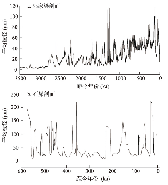 新窗口打开|下载原图ZIP|生成PPT
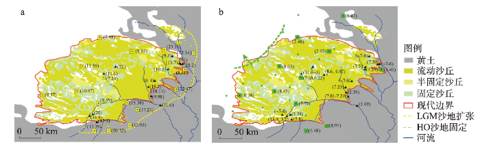 新窗口打开|下载原图ZIP|生成PPT
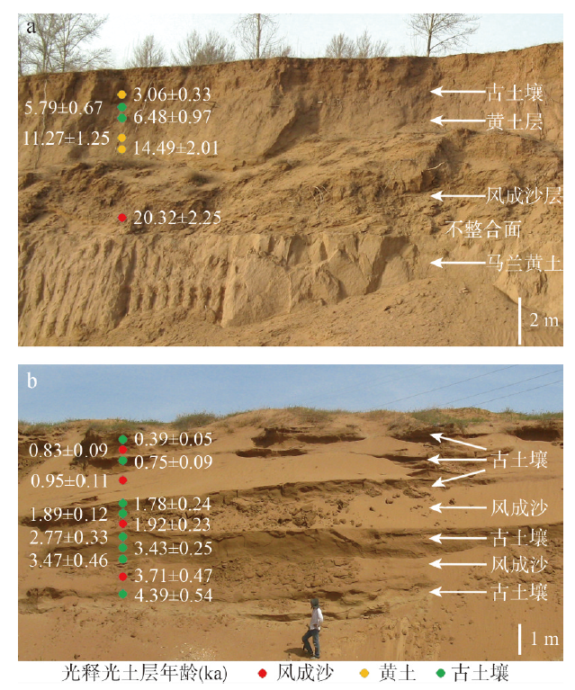 新窗口打开|下载原图ZIP|生成PPT
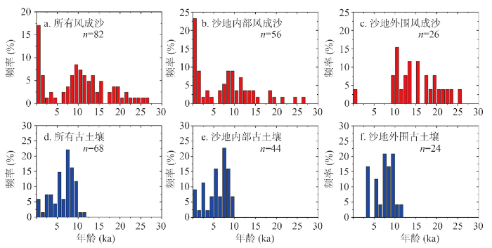 新窗口打开|下载原图ZIP|生成PPT
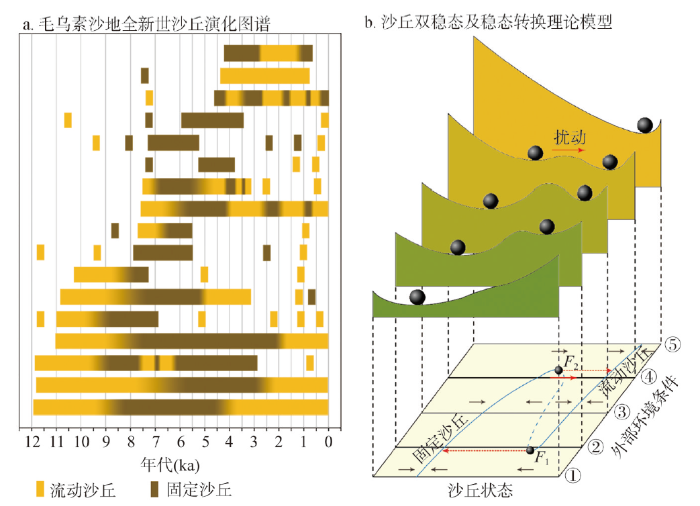 新窗口打开|下载原图ZIP|生成PPT
