 ,1,2, 朱连奇1,2, 李国栋,1,2, 赵芳1,2, 秦静婷1,2
Spatial patterns of SOC/TN content and their significance for identifying the boundary between warm temperate and subtropical zones in China's north-south transitional zone
ZHANG Junhua,1,2, ZHU Lianqi1,2, LI Guodong,1,2, ZHAO Fang1,2, QIN Jingting1,2通讯作者:
收稿日期:2020-06-29修回日期:2021-07-6
| 基金资助: |
Received:2020-06-29Revised:2021-07-6
| Fund supported: |
作者简介 About authors
张俊华(1975-), 女, 河南舞阳人, 博士, 教授, 主要从事土壤碳氮特征与土壤质量研究。E-mail:

摘要
关键词:
Abstract
Keywords:
PDF (4827KB)元数据多维度评价相关文章导出EndNote|Ris|Bibtex收藏本文
本文引用格式
张俊华, 朱连奇, 李国栋, 赵芳, 秦静婷. 中国南北过渡带土壤碳氮空间特征及暖温带与亚热带界限. 地理学报, 2021, 76(9): 2269-2282 doi:10.11821/dlxb202109016
ZHANG Junhua, ZHU Lianqi, LI Guodong, ZHAO Fang, QIN Jingting.
1 引言
秦岭—大巴山(秦巴山区)是中国陆地生态系统南北过渡带(区)的主体,东西长>1000 km,介于102°E~114°E。区内兼具南北地理环境特点,生物种类多样,是中国重要的物种库。多列山体的分布及阻隔效应形成了自东向西、自南向北、自山麓向山顶特有复杂的自然环境过渡特征和特色的地域人地关系系统。作为中国自然地理的过渡地带,必然具有气候变化的敏感性[1]。复杂的地理环境和过渡特征对气候变化的响应程度和变化强度不同,识别南北分界的范围和区内各环境要素的变化有助于进行中国自然区划的精确划定、环境及物种资源的保护,并为区域发展提供决策依据。在全球气候变化背景下,过渡区气候、植被、土壤、水文等发生变化,各要素均存在过渡效应和空间分异特征。有关气候[2,3,4]、植被分布[5,6]、气候—植被参数[7]、山体效应[8,9]已开展大量工作,对北亚热带—暖温带的划界更多依据气候、植被要素而定。竺可桢首次以≥10 ℃积温在4500~8000 ℃、最低月均温2~16 ℃,无霜期240~365 d作为亚热带划分指标,其北界接近34°N,沿淮河—秦岭—白龙江至104°E [10];温暖指数[11]、800 mm等雨量线也被采用作为划界指标;在植被方面,以植物类型、区系成分、温带属/热带属比值、山地垂直带谱[7, 12]来界定;考虑气候—植被—地形的关系,秦岭南麓约800~1000 m之间可作为亚热带北界[7, 13-14]。受自然环境要素空间变化及各区响应幅度差异性的影响,对南北过渡带的划界结果不同,采用什么指标更为合适和科学,已是必须面对的问题[1]。目前,秦岭主脊、秦岭分水岭、秦岭南坡、秦岭北坡、大巴山都是学界认可的亚热带与暖温带分界线[8, 15-16]。
土壤是过渡带的核心部分,是多种因素经过长期作用综合演化的产物,土壤性质或属性能够反映各因素的作用及区域地理特征。与气候、水文要素相比,土壤短期内不易发生变化,具有较强的稳定性和指示作用,土壤关键指标的变化和空间分异更能反映多种因素在某一时段的综合作用及过渡效应。在亚区域典型山体样带水平的研究表明,土壤类型及性质呈现南北渐变的过渡特征[17,18],因地形复杂、范围广、调查取样工作量大、指标测试耗时长等因素限制,整体对秦巴山区土壤性质空间特征开展系统研究及与过渡带界限联系较少。有机碳是土壤中生命物质的载体和骨架,与各种元素的耦合过程具有同步和协同效应,全氮含量是仅次于有机碳的生物必需营养元素,有机碳/全氮是土壤分类划分的依据和主要诊断特性[19,20],能够敏感指示成土过程指标变化并反映土壤地带性规律[21,22]。基于此,本文选取土壤有机碳、全氮两个指标,综合考虑地形、植被、气候要素分布特征及与土壤有机碳/全氮的空间关系,探讨秦巴山区土壤碳氮变化及与中国南北过渡带界限问题,为明确新的研究方向和聚焦热点区域提供一定科学依据。
2 数据来源与研究方法
2.1 数据来源
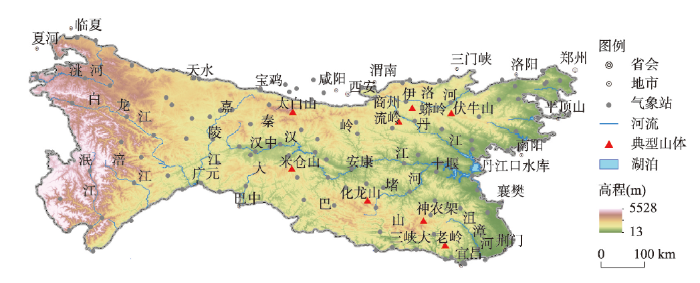
研究区分布及空间范围如图1,跨河南、陕西、甘肃、湖北、重庆、四川6省市,海拔在13~5528 m之间,地势西高东低,地形以山地、盆地、丘陵为主。文中数据来源于《中国土种志(6卷)》、各省土种志和全国土壤普查办公室1995年编制的《1:100万中华人民共和国土壤图》,综合考虑土壤类型空间分布范围及相邻类型间的差异、山体走向、地形、植被、气候等因素,采用空间分布相对均匀、相邻土种之间增加样点的原则,从土种的土壤属性数据库[23],提取分辨率约为4 km×4 km水平上样点的土壤pH值、有机碳(SOC)、全氮(TN)和不同粒径的颗粒物含量。气温、降水数据来源于国家气象信息中心(图1
 新窗口打开|下载原图ZIP|生成PPT
图1研究区及气象台站分布略图
Fig. 1Map of the study area and meteorological stations
2.2 研究方法
利用GS9+筛选有机碳/全氮含量空间模型,决定系数值越大、残差越小是选择标准,半变异函数模型均为指数型。在ArcGIS 10.1中,采用普通克里格模拟有机碳/全氮空间分布,选取平均误差(ME)、平均标准误差(ASE)、均方根误差(RMSE)、均方误差(MSE)、均方根标准误差(RMSSE)进行拟合精度判断[24]。以经度、纬度和海拔为独立变量,利用ANUSPLINE软件的薄盘样条法进行全区气温、降水空间插值[25,26],提取各土壤样点的年均温(MT)、年降水量(MP)、各季均温(MT春、MT夏、MT秋、MT冬)、各季降水量(MP春、MP夏、MP秋、MP冬)及1月和7月气温;从地形图提取各样点海拔、坡度;植被分布和植被垂直带谱的数据来源于《陕西植被》《中国植被》和已发表的成果[8]。依据地表起伏和有机碳/全氮的空间分布,筛选出反映土壤碳氮变化的400 m垂直间隔。为区分1000 m附近植被—地形的影响,特划出800~1000 m等级;由于> 3000 m土壤调查的样点数少,归为一类;最终划分[51, 400 m]、(400, 800 m]、(800, 1000 m]、(1000, 1400 m]、(1400, 1800 m]、(1800, 2200 m]、(2200, 2600 m]、(2600, 3000 m]、(3000, 4906 m]共9个海拔等级,分析有机碳/全氮与海拔、坡向的关系及其在秦岭—大巴山南北坡的垂向变化规律;分析/识别典型山体植被带谱的垂向分布及过渡特征,并以秦岭南坡(太白山、蟒岭、流岭、伏牛山)、大巴山北坡(米仓山、化龙山、神农架、三峡大老岭)和嘉陵江以西的白龙江自然保护区山体为例,建立暖温带—亚热带过渡区植被带谱与有机碳/全氮含量的空间垂直关系;从垂直和空间两个角度,分析气温/降水与有机碳/全氮的关系;在此基础上,综合考虑地形—植被—气候—土壤要素的空间过渡特征,界定秦巴山区过渡带分布范围,分析区域气候指标特征。
3 结果与分析
3.1 土壤性质基本特征
区内土壤有机碳含量在0.64~71.40 g/kg之间,均值为21.49 g/kg。全氮含量介于110~7710 mg/kg之间,均值1918.95 mg/kg。有机碳、全氮呈正偏斜、低峰态型分布。对照国家第二次土壤普查推荐的养分标准,土壤有机碳、全氮在6个分级标准中均有分布,说明区内土壤有机碳、全氮空间差异性较大,且有机碳的含量和空间变化幅度明显高于全氮;土壤pH值在4.60~8.80之间,均值6.30,以酸性土、弱碱性土为主。土壤颗粒以< 2 mm为主,其中0.002~0.02 mm、< 0.002 mm的含量分别占64.76%、18.70%。Tab. 1
表1
表1土壤性质基本统计特征
Tab. 1
| 指标 | 最小值 | 最大值 | 平均值 | 标准差 | 偏度 | 峰度 |
|---|---|---|---|---|---|---|
| 有机碳(g/kg) | 0.64 | 71.40 | 21.49 | 18.31 | 1.00 | -0.39 |
| 全氮(mg/kg) | 110. 00 | 7710.00 | 1918.95 | 1408.34 | 0.80 | -0.78 |
| pH | 4.60 | 8.80 | 6.30 | 1.25 | 0.27 | -0.99 |
| 土壤颗粒 | ||||||
| 0.2~2mm | 0.00 | 95.49 | 18.00 | 18.26 | 1.77 | 4.25 |
| 0.02~0.2mm | 0.00 | 74.26 | 34.13 | 15.09 | -0.44 | 0.55 |
| 0.002~0.02mm | 1.20 | 66.10 | 30.63 | 12.42 | 0.59 | 0.01 |
| <0.002mm | 3.10 | 52.22 | 18.70 | 6.68 | 0.48 | 0.67 |
新窗口打开|下载CSV
3.2 土壤有机碳/全氮空间特征
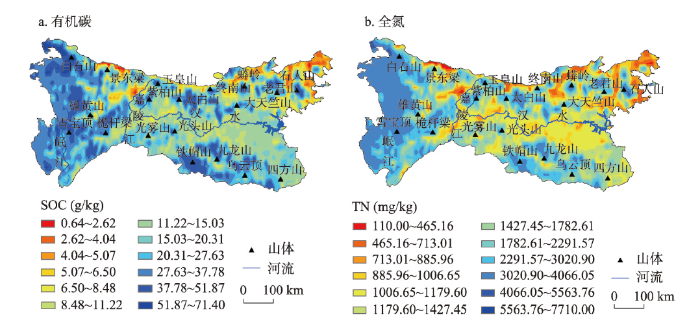
有机碳在空间上存在3个高值区、1个次高值区和1个低值区(图2)。东西向,在秦岭、大巴山海拔较高的山地为2个高值区,有机碳含量在15.03~51.87 g/kg之间,南北向上,嘉陵江以西的山地为全区最高,有机碳含量在15.03~71.04 g/kg之间。次高值区位于秦岭—大巴山之间的汉江两侧、自西向东呈现南北向宽幅逐渐增大的“喇叭状”变化趋势,有机碳含量在6.50~15.03 g/kg之间;低值区沿秦岭北坡,自西向东经陕西渭河谷地、南五台山、华山和河南的伏牛山区,有机碳含量在0.64~8.48 g/kg之间。全氮在区内的空间分布、变化趋势与有机碳吻合,高值区、低值区含量分别为1782.61~7710.00 mg/kg、110.00~885.96 mg/kg,次高值区介于二者之间。土壤有机碳/全氮含量的高值区—次高值区间的渐变趋势不明显,但分区界限清晰。从含量和分布上,汉江两侧及东部的低矮山体、秦岭北坡土壤有机碳/全氮含量低,易受外在因素影响而发生变化。表2为拟合模型的精度及参数值。图2
 新窗口打开|下载原图ZIP|生成PPT
图2秦巴山区土壤有机碳/全氮空间分布特征
Fig. 2Spatial distribution of SOC and TN in the Qinling-Daba Mountains
Tab. 2
表2
表2土壤有机碳/全氮空间分布的模拟误差
Tab. 2
| 名称 | 平均误差(ME) | 均方根误差(RMSE) | 平均标准误差(ASE) | 均方误差(MSE) | 均方根标准误差(RMSSE) |
|---|---|---|---|---|---|
| SOC | 0.02 | 12.84 | 9.24 | 0.00 | 1.40 |
| TN | 0.85 | 963.83 | 914.89 | 0.00 | 1.05 |
新窗口打开|下载CSV
3.3 地形与土壤有机碳/全氮的关系
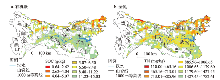
地形通过影响植被、气候、生物等要素分布来改变地表生物活动、土壤碳氮过程及含量分布[27,28,29]。空间上,有机碳/全氮的次高值区(秦岭北坡除外)主要分布在海拔低于1000 m的区域,1000 m及以上的区域与高值区分布一致(图3)。在秦岭南坡流岭—鹰咀石之间,海拔基本都在1000 m以上,低于1000 m的区域分布于山体之间,有机碳/全氮高值区(1000 m及以上)的分布掩盖了< 1000 m的空间特征,使该区碳氮次高值区分布与1000 m等高线不一致;秦岭南坡中段偏西—汉中盆地北部略高于1000 m的山区,也是有机碳/全氮次高值分布区。伏牛山区,南坡有机碳/全氮的含量高于北坡,次高值区大体在南坡< 1000 m区域及北坡靠近山脊线的部分区域。秦岭北坡为低山、河谷平原区,有机碳/全氮含量偏低。图3
 新窗口打开|下载原图ZIP|生成PPT
图3秦巴山区海拔<1000 m的分布区与土壤有机碳/全氮的空间关系
Fig. 3Spatial relationship between SOC/TN distribution and elevation below 1000 m
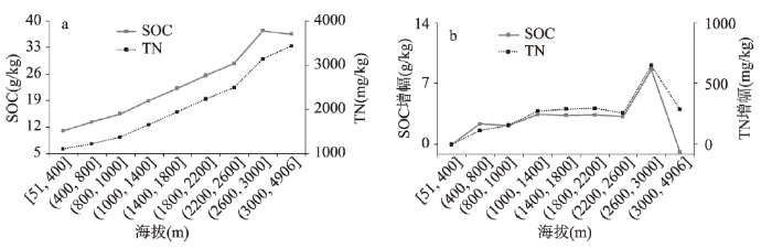
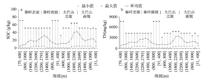
垂向上,有机碳/全氮的变化趋势如图4。全区,随海拔升高有机碳/全氮含量呈先缓慢增加、后快速升高的变化趋势,800~1000 m的高度可作为衡量碳氮含量和增幅变化的分界点,1000~3000 m的有机碳/全氮含量和增幅(分别为3.19~8.65 g/kg、258.09~651.75 mg/kg)明显高于< 1000 m区域(分别为2.17~2.37 g/kg、112.41~156.71 mg/kg);嘉陵江以西> 3000 m的山地,有机碳含量/变幅降低、全氮变幅降低。仅考虑嘉陵江以东的秦岭南坡—大巴山北坡区域,有机碳/全氮的垂向变化趋势与全区一致,其含量、增幅均在800~1000 m出现拐点,在2200~2600 m接近山脊的区域呈降低趋势。相关分析显示,≤ 800 m和>3000 m区域,坡度与有机碳/全氮含量呈显著性相关;800~3000 m之间,坡度与有机碳/全氮含量呈弱相关,表明坡度、海拔在≤ 1000 m和>3000 m区域是有机碳/全氮变化的重要影响因素,而海拔是1000~3000 m土壤变化的主控因素。
图4
 新窗口打开|下载原图ZIP|生成PPT
图4秦巴山区土壤有机碳/全氮含量和增幅与海拔关系
Fig. 4Content and increasing range of SOC/TN and their relationships with altitude
南北向上,有机碳/全氮含量与海拔关系如图5,从北向南,大致以山脊为界,有机碳/全氮均值和最小值呈“双峰型”变化趋势。相同海拔高度,秦岭南坡的碳氮含量高于北坡;大巴山1400 m及以下区域,同高度内的南坡土壤碳氮含量高于北坡,而>1400 m的区域,同高度内的北坡碳氮含量高于南坡;秦岭南坡800~1000 m至大巴山北坡1000~1400 m,土壤碳氮变化平稳,含量分别为9.93~15.66 g/kg、1019.00~1386.00 mg/kg。对比发现,秦岭南坡—大巴山北坡> 1000 m的区域有机碳/全氮较≤ 1000 m的区域含量高、增幅大,这是1000 m出现拐点的原因。嘉陵江以西,≤ 500 m和500~2200 m区域,有机碳/全氮含量分别为15.29~20.75 g/kg、1356.79~1864.32 mg/kg,随海拔升高呈缓慢升高趋势,>2600 m碳、氮含量分别为36.64~37.80 g/kg、3158.82~3433.42 mg/kg,变化趋势与全区一致(图4)。
图5
 新窗口打开|下载原图ZIP|生成PPT
图5秦巴山区南北向土壤有机碳/全氮含量变化及与海拔关系
Fig. 5Altitudinal variance in SOC/TN from north to south in the Qinling-Daba Mountains
从空间、垂直和南北向上,有机碳/全氮含量及增幅均在秦岭南坡—大巴山北坡800~1000 m出现拐点。海拔与土壤有机碳/全氮的关系实质上是地形引起了各自然地理要素的空间/垂向变化,各要素的综合效应及动态过程是驱动土壤碳氮变化的最根本原因。
3.4 植被与土壤有机碳/全氮的关系
自然生态系统中,地表植被类型及其凋落物归还是土壤有机物的主要来源及有机碳/全氮含量的关键影响因素,植被类型分布或植被带谱空间格局能够反映区内植物的过渡效应及与土壤类型、性质的空间关系。现有研究表明,大巴山南坡及其东部基面高度以上出现亚热带常绿阔叶林带[30,31,32,33],秦岭北坡东西向山地基带以上以温带、暖温带植物类型为主[34,35];白水江自然保护区基面以上(600~950 m)为亚热带常绿阔叶混交林,自此向西的高大山体,植被带谱的过渡特征不明显。秦岭南坡东西向山地基面以上出现了暖温带落叶阔叶林带(含常绿成分)[35,36]、大巴山北坡基带以上为亚热带常绿落叶阔叶混交林带[31-32, 37],植被类型及垂直带谱兼具了暖温带—亚热带的特征,呈现南北过渡特点。从过渡区典型山体垂直带谱的高度、带宽上(图6),秦岭南坡暖温带落叶阔叶林(含常绿成分)分布范围为,太白山南坡在500~1000 m、伏牛山南坡在600~1100 m、流岭—莽岭在200~1300 m;大巴山北坡亚热带常绿落叶阔叶混交林带分布范围为,米仓山北坡在500~1200 m、化龙山在215~900 m、神农架北坡在600~1100 m[32];其中太白山南坡、伏牛山南坡、米仓山北坡、化龙山北坡、神农架北坡,暖温带落叶阔叶林带(含常绿成分)和亚热带常绿落叶阔叶混交林带的上限大体与有机碳/全氮的次高值区上限、1000 m等高线吻合;而流岭—莽岭200~1300 m植被带谱的带宽增加,即下限下移、上限上移,有机碳/全氮的次高值区与1000 m等高线、暖温带落叶阔叶林带(含常绿成分)呈错位分布,植被带谱上限分布偏北(上)、有机碳/全氮偏南。在典型山体中,秦岭南坡800~1000 m有机碳/全氮的平均含量分别为7.44~10.17 g/kg、688.80~984.54 mg/kg,自西向东,有机碳/全氮含量呈降低趋势;大巴山北坡800~1000 m有机碳/全氮分别为10.94~13.15 g/kg、1038.89~1227.78 mg/kg,自西向东,有机碳/全氮含量呈升高趋势。南北向上,800~1000 m有机碳/全氮含量呈现米仓山>太白山、化龙山>流岭(蟒岭)、神农架>伏牛山的趋势。除伏牛山全氮含量略低于次高值区外,其他各山体有机碳/全氮含量均处于次高值区的范围。综上,在汉江两侧,太白山南坡—大巴山北坡之间夹持的海拔 < 1000 m、伏牛山区< 1000 m及流岭—莽岭略高于1000 m的区域是亚热带—暖温带植被过渡带谱分布区,其与有机碳/全氮含量次高值区的分布基本吻合。
图6
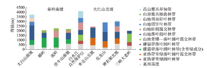 新窗口打开|下载原图ZIP|生成PPT
图6秦岭南坡—大巴山北坡典型山体垂直带谱分布
Fig. 6Mountain altitudinal belts on the southern slope of the Qinling Mountains and the northern slopes of the Daba Mountains
3.5 气候与土壤有机碳/全氮关系及过渡区气候特征
3.5.1 气温/降水与有机碳/全氮的关系 气候是影响植被类型分布格局和土壤类型/性质变化的重要因素,在地形、植被与有机碳/全氮空间和垂向关系的分析基础上,进一步探讨气候要素分布特征及对碳氮的影响。分析发现(图7),海拔≤ 1000 m,全年、4个季节降水对有机碳/全氮的作用强于气温,且气温、降水与有机碳/全氮均呈显著正相关,相关系数分别为0.05~0.39、0.03~0.32,夏、冬和春季降水量的作用强于秋季;海拔> 1000 m,气温对碳氮作用强于降水,气温、降水(除MP夏)与碳氮呈显著负相关,相关系数分别为-0.01~-0.34、-0.03~-0.45,春、夏和秋季气温的作用强于冬季;全氮与气温/降水的关系和有机碳基本一致。4个季节中,降水和气温通过影响地表植物生长、凋落物归还和土壤生物活动来影响土壤碳氮过程。≤ 1000 m的降水、气温与有机碳/全氮正相关,春季、夏季是植物和土壤生物生命活跃期,降水量增加有利于植物生长,促进地表生物量累积及有机物归还量,提高了土壤碳氮含量;而冬季气温低、降水少、生物分解作用弱,有助于凋落物的腐解和积累;秋季,降水对土壤碳氮的提升作用降低,这与植物生长速度变缓和生物分解作用活跃有关。有机碳/全氮与> 1000 m降水(除MP夏)、气温负相关,且温度的作用强度大于降水,说明海拔升高,气温降低,低温不利于生物生长,同时弱化了降水的作用,减缓了有机物的分解转化过程,促进有机物累积和碳氮含量提升。图7
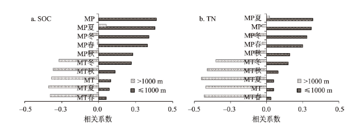 新窗口打开|下载原图ZIP|生成PPT
图7秦巴山区不同海拔土壤有机碳/总氮与气温/降水的相关特征
注:P < 0.01。
Fig. 7Correlation between SOC/TN and MP/MT at different elevations
从全年及4个季节气温、降水的空间分布上看,年均温在秦巴山地夹持的区域、大巴山南部及东部伏牛山区为高值区,嘉陵江以西及秦岭主脊为低值区(图8),春、夏和秋季均温与年均温的空间分布趋势较为一致,冬季气温的高值区南移、低温区整体南扩;年降水量与年均温分布不同,年降水量在大巴山区最高(987~1332 mm),秦岭西段最低(398~596 mm),二者夹持的区域在596~987 mm之间。4个季节中,春、秋季降水量与年降水量的空间分布趋势一致,冬季降水量整体南移、呈西南—东北向的分布,夏季降水量较春、秋和冬季高。分析发现,有机碳/全氮含量的次高值区是4个季节气温/降水南北向波动幅度较大的区域。通常,植物的光合作用、生长发育起点温度在5~10 ℃,热带植物生长最低温略高于温带。冬季,全区气温低于9.42 ℃,植物发育缓慢或停止生长;在秦巴山地之间的低山、河谷区,春、夏和秋季气温在10.09~29.69 ℃,满足了温带、亚热带植物的生长需求。综合来看,秦巴山区之间及东部伏牛山区是气温/降水季节性变化的敏感区和交汇区,是过渡带植被和有机碳/全氮次高值区分布的重要影响因素。
图8
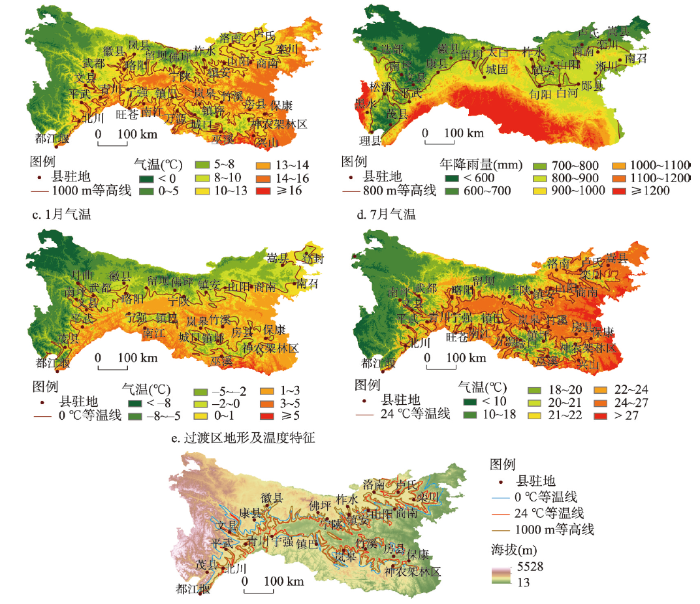 新窗口打开|下载原图ZIP|生成PPT
图8秦巴山区气温/降水的空间分布与过渡带主体区
Fig. 8Spatial distribution of temperature and precipitation and the main region of the transitional zone in the Qinling-Daba Mountains
基于以上分析,考虑山脊线、植被带谱、土壤有机碳/全氮次高值区、1000 m等高线、气温/降水各因素作用和分布,提取秦岭南坡—大巴山北坡1月0 ℃等温线、7月24 ℃等温线、800 mm等雨量线与1000 m等高线(图8a~8d),发现1月0 ℃等温线、7月24 ℃等温线与1000 m等高线基本一致,该区也是土壤有机碳/全氮次高值区的主要分布区(图8e),自西向东,北界沿都江堰—茂县—平武—文县—康县—徽县—佛坪—宁陕—镇安—山阳—商南—栾川—卢氏—洛南一线分布,南界沿都江堰—北川—青川—宁强—镇巴—岚皋—竹溪—神农架林区分布,在伏牛山和嘉陵江以西,1月0 ℃等温线与1000 m等高线、7月24 ℃等温线略有偏差,其它各区分布趋势较一致,说明秦岭南坡和大巴山北坡1000 m高度是土壤、植被、气候变化的重要分界线,二者夹持的范围是亚热带向暖温带过渡的主体分布区。
3.5.2 过渡区气候特征 秦岭南坡、大巴山北坡和嘉陵江以西海拔在1000 m及以下的区域(表3),1月气温-4~5 ℃,均值在1~2 ℃,年降雨量在678~1578 mm。各区1月气温、7月气温、年均温及各季气温的最低值、最高值和平均值接近,年内变化趋势一致,年降雨量均大于800 mm,且集中在春、夏、秋季。从各指标来看,过渡区内降雨在各季的变幅大,而气温在年内的变化较稳定,相比而言,气温的变化较降水更能敏感、准确地反映过渡带的变化。
Tab. 3
表3
表3秦巴山区过渡区气候指标特征
Tab. 3
| 气候指标 | 秦岭南坡 | 大巴山北坡 | 嘉陵江以西 |
|---|---|---|---|
| 1月气温(℃) | -4~4(1) | -2~4(2) | -3~5(2) |
| 7月气温(℃) | 16~28(25) | 18~28(25) | 18~25(23) |
| MT(℃) | 7~16(13) | 8~16(14) | 9~16(13) |
| MP(mm) | 678~1152(834) | 739~1494(936) | 560~1578(1022) |
| MP春(mm) | 142~239(180) | 151~317(221) | 120~208(168) |
| MP夏(mm) | 316~562(402) | 315~697(417) | 312~962(575) |
| MP秋(mm) | 169~370(231) | 203~416(268) | 140~327(240) |
| MP冬(mm) | 5~33(19) | 9~42(24) | 6~45(16) |
| MT春(℃) | 8~16(13) | 8~16(14) | 10~16(14) |
| MT夏(℃) | 15~27(24) | 16~27(24) | 17~25(22) |
| MT秋(℃) | 8~16(14) | 8~17(14) | 9~16(13) |
| MT冬(℃) | -3~5(2) | -1~6(3) | -1~6(3) |
新窗口打开|下载CSV
4 结论与讨论
4.1 讨论
有机碳/全氮分布与地形、植被、气候要素的空间关系能较好地反映区域特征和过渡效应。土壤有机碳与全氮的空间分布趋势较为一致,二者空间相关性为0.97。从气候、植被、土壤空间变化上,土壤有机碳/全氮的次高值区分布与亚热带—暖温带植被带谱过渡区分布吻合,大致以秦岭南坡—大巴山北坡1000 m等高线为界,其北界与马建华[13]、张学忠[5]、康慕谊[7]、姚永慧[38]等的结果相一致。该区1月均温为1~2 ℃、7月均温23~25 ℃,年降雨量678~1578 mm(秦岭南坡< 1000 m、大巴山北坡< 1000 m)、年内4个季节气温/降水均值接近或相等,气候指标具有过渡带特征[8, 39],表明土壤有机碳/全氮的空间特征及次高值区分布范围可作为亚热带—暖温带的划界依据。1000 m等高线可为中国南北过渡带划界提供可靠依据,但不同区域存在差异,在秦岭中段(太白—米仓山)与1000 m等高线较吻合,自中段向秦岭东段的伏牛山区,变化趋于复杂,多因素的综合效应渐强,垂直高度/南北向幅度也复杂,过渡带北界与1000 m等高线分布略有不同。气候变化背景下,气温升高、降水量增减影响植被类型分布、有机物归趋及土壤性质动态变化,植被、土壤的变化幅度滞后于气温、降水,但南北向气温/降水量变化大、过渡效应明显的区域,往往是植被、动物、水文、土壤等因素处于重组中,具有敏感、易变、不稳定等特征。从响应强度上,土壤性质、植被类型较气温、降水具有强的稳定性,更能反映过渡区的过渡效应。另外,气候变化背景下气温、降水的波动及其空间格局造成的假象,不能全面反映北亚热带—暖温带的真实特征和边缘效应,需考虑土壤—植被—气候—地形因素的综合作用及其互作机制,迫切需要开展土壤剖面指标变化及成土过程研究。
土壤有机碳/全氮含量的次高值分布区,一方面受海拔、地形、植被、气候等自然因素的影响,另一方面,该区人口高度集中分布,农业耕作、居民生活等人为因素作用强度大。从同期土地利用类型和典型山体植被带谱图来看,区内农业用地与土壤碳氮次高值区的分布并不吻合,农业用地主要分布在基带的地势平缓区及汉江两侧盆地区[40,41], > 1000 m山地的缓坡也有分布,各区分布面积和高度不同,识别不同区域人为和自然因素的影响强度也是准确评价过渡带分界及过渡效应的重要因素。
4.2 结论
秦巴山区土壤有机碳/全氮含量在空间上分布趋势一致,存在3个高值区、1个次高值区和1个低值区,高值区分布在秦岭、大巴山的高海拔和嘉陵江以西的山地,含量分别为15.03~71.04 g/kg、1782.61~7710.00 mg/kg;低值区沿秦岭北坡的渭河谷地、南五台山、华山和伏牛山分布,含量分别为0.64~6.50 g/kg、110.00~885.96 mg/kg;次高值区主要在汉江两侧、秦巴山地之间夹持的海拔< 1000 m、伏牛山< 1000 m及嘉陵江两侧略高于1000 m的山体,含量介于以上二者之间,自西向东呈现南北向宽幅逐渐增大的“喇叭状”变化趋势。高值区、次高值区和低值区之间的渐变趋势不明显,但分区界限清晰。综合考虑地形—植被—气候的空间特征及作用,发现土壤有机碳/全氮含量次高值区的分布范围与1000 m等高线、暖温带落叶阔叶林带(含常绿成分)和亚热带常绿落叶阔叶混交林带分布上限基本一致。该区是亚热带向暖温带过渡的主体区,分布在汉江两侧,自西向东,北界沿都江堰—茂县—平武—文县—康县—徽县—佛坪—宁陕—镇安—山阳—商南—栾川—卢氏—洛南一线分布,南界沿都江堰—北川—青川—宁强—镇巴—岚皋—竹溪—神农架林区分布。区内气温/降水的季节性变化、1月气温、7月气温和年降雨量均可反映过渡区的气候特征。研究表明,土壤有机碳/全氮的含量变化及次高值区分布可为北亚热带—暖温带的划界提供依据。
土壤有机碳/全氮的空间特征能够反映土壤与地形、植被、气候要素的空间关系及过渡区分布,但不能全面揭示不同区域、不同山体关键的生态学过程和垂向变异机理。进一步加密采样地点,选取典型区、典型山体和敏感区开展有机碳/全氮组分特征、土壤生物过程及多因素影响下的剖面发育过程及动态特征,可识别秦巴山区土壤与环境因素之间的关系及多维度变化特征。
参考文献 原文顺序
文献年度倒序
文中引用次数倒序
被引期刊影响因子
DOI:10.18306/dlkxjz.2019.03.001 [本文引用: 2]

Since the Qinling-Huaihe line was delimited as the boundary between north and south China in 1958, discussions on the local position of the line, criteria for dividing temperature zones, the line's environmental effect, among others, are ongoing. The National Basic Resources Investigation Program "Integrated Scientific Investigation of the North-South Transitional Zone" launched in 2017, introduced the concept of north-south transitional zone (Qinling-Daba Mountains) and planned to explore the north-south dividing line from the perspective of transitional zone, so as to strengthen and make some breakthroughs in the study of the north-south division. The Qinling-Daba Mountains are the main body of China's north-south transitional zone, with multi-dimensional zonal structures and high degree of environmental complexity, biological diversity, and climatic sensitivity. The following 10 scientific issues need to be dealt with in the years to come: 1) The relationship between the north-south dividing line and the north-south transitional zone; 2) improvement of criteria for identifying subtropical and warm-temperate zones; 3) integral north-south series and variation of vegetation and soil types; 4) relationship between global warming and spatial change of key bioclimatic criteria; 5) decomposition and integration of multi-dimensional zonal structures in the Qinling-Daba Mountains; 6) pattern and mechanism of biological diversity and endemics; 7) the corridor effect of the Qinling-Daba Mountains; 8) regional environmental effect of the Qinling-Daba Mountains and implications for the national ecological security; 9) significance and position of the Qinling-Daba Mountains for the history and development of China; and 10) significance of the geographic structure of Western Qinling Mountains for the origin of the Chinese civilization. These key issues are not only the results of previous research, but also the starting point for further exploration and study in the future. They are intended to inspire and encourage an in-depth study of China's north-south dividing line or transitional zone, and to provide new perspectives and framework for the exploration of physio-geographic theories, biodiversity, and ecological security, and even the birthplace of the earliest Chinese civilization.
[本文引用: 2]
[本文引用: 1]
[本文引用: 1]
[本文引用: 1]
[本文引用: 1]
DOI:10.11821/dlxb201801002 [本文引用: 1]
A study on temperature variations in the northern and southern Qinling Mountains is performed using temperature series at 70 meteorological stations for the period 1970-2015. Temporal trends, spatial characteristics, 0 ℃ isotherm displacement and the number of days with active accumulated temperature above 10 ℃ are evaluated, using extreme-point symmetric mode decomposition (ESMD), spatial analysis and other climate diagnosis methods. The significance of climatic boundary line of the Qinling Mountains is explored in the context of global warming. Four new insights have been achieved: (1) The changing trends of temperature in the northern and southern Qinling Mountains over the past 46 years are synchronous, with the warming process shown as a 'non-smooth, nonlinear, and ladder-shaped' pattern. The evolution process can be divided into three periods: the low stationary fluctuation period in 1960-1993, followed by a rapid increase period in 1994-2002, and finally a warming stagnation period in 2003-2015. (2) The ESMD decomposition indicates that the changing trends of temperature over the northern and southern Qinling Mountains are dominated by interannual fluctuation, and have no obvious linear trend. (3) The spatial variation of temperature in the Qinling Mountains is characterized by 'synchronous warming, and differential north-south change'. In the north, the spatial variation of temperature is relatively consistent, while in the south low temperature centers are observed at Xixiang-Ankang basin and Shangdan basin. (4) The Qinling Mountains, as a climatic boundary line, still play a major/obvious role; however, there exists difference in the response of temperature variations to global warming over the north and south of the Qinling Mountains. The northern boundary of north subtropical zone extends upward along the southern Qinling Mountains; while warming zone extends by the form of enclave in the northern Qinling Mountains due to rapid urbanization and mountain blocking.
[本文引用: 1]
DOI:10.11821/xb197904006 [本文引用: 2]
This paper states the distribution of 177 species (including their varieties) of broadleaf woody evergreens on the Qin-lin Mountain, based on the viewpoint of specific phytogeographic or floral elements. It is possible to classify these species into two groups: One may be considered as that belongs to typical subtropical floral elements which are located on the southern slope of Qin-lin Mountain (Table 3); the other may be belong to the temperate ones which are found on the northern slope of the Qin-lin Mountain (Table 4). According to the distribution of above-mentioned floral elements, the northern boundary of the subtropical zone of China is located near 1000 m. above sea level on the southern slope of central part of Qin-lin Mountain, lying approximately from Latitude 33°5’, Wudu of Gansu Province, to 33°5’ North, the southern slope of the Funiu Mountain of Henan Province.
[本文引用: 2]
DOI:10.11821/yj2010090009 [本文引用: 1]
The Qinling Mountain Range is considered as an important geo-ecological boundary between the warm temperate and the subtropical zones in eastern China, however, the specific line of the boundary has been controversial among the academic circles. Several studies based on vegetation ecology and flora geography have been done on discussing the division of this boundary, but in all of which Pteridophyta is not included. Pteridophyta is a transitional link between different flora groups in plant evolution, and thus is more sensitive to the environment that fosters it than other plant groups. It is conducive to and necessary for a better understanding of the division of the geo-ecological boundary in Qinling Mountain Range to research into the Range's Pteridophyta flora. In this paper, the composition and geographical elements of the flora of Pteridophyta were studied, and the division of the vertical Pteridophyta spectrum and the further division of the geo-ecological boundary in Qinling Mountain Range were also discussed, by applying the principles of classical florology and using quantitative ecology method as TWINSPAN and DCA into the analyses, based on comparison between the field investigation data and the relevant literatures. The results of our research have shown and revealed: 1) There are 311 species of Pteridophyta, belonging to 85 genera and 36 families in the Qinling Mountain Range; in which the dominant families are Dryopteridaceae, Athyriaceae, and Polypodiaceae, and the dominant genera Dryopteris and Polystichum; meanwhile, the main areal-types of family and genera are tropical elements, while the areal-types of species is dominated by the temperate elements. 2) The altitude of 1000 m a.s.l. at the southern piedmont of the Range should be an important ecological boundary, since the floristic composition of the Pteridophyta below this elevation showed more similar features to the subtropics, while above it the features of the composition and the vertical vegetation spectrum of the Pteridophyta are much closer to the temperate zones. 3) DCA ordination of FER (floristic element ratio) among 15 regions in northern and southern China and the both sides of Qinling Mountain Range strongly supported the hypothesis mentioned above. Based on these results, we tend to deem that the geo-ecological boundary between the subtropical and warm temperate zones lies around the altitude of 1000 m a.s.l. at the southern piedmont of the Range.
[本文引用: 1]
[本文引用: 4]
[本文引用: 4]
[本文引用: 4]
[本文引用: 4]
[本文引用: 1]
[本文引用: 1]
[本文引用: 1]
[本文引用: 1]
[本文引用: 1]
[本文引用: 1]
[本文引用: 1]
[本文引用: 1]
[本文引用: 2]
[本文引用: 2]
DOI:10.11821/xb198102010 [本文引用: 1]
一、前言 亚热带与暖温带的分界线,在我国是一条重要的自然界线,它的划分问题,引起了自然地理学、气候学、土壤学和地植物学等科学工作者的争论。研究这个问题不仅在理论上具有重要意义,而且它是综合自然、农业、林业等区划的依据之一。所以,亚热带与暖温带分界线的划分,能否正确地反映自然界的客观规律,是关系到运用这规律来指导生产实践的大问题。
[本文引用: 1]
[本文引用: 1]
[本文引用: 1]
DOI:10.11821/xb198003003 [本文引用: 1]
The division of natural zones is decided by the features of all round natural conditions.Since the formation of natural zones is mainly controlled by zonal factors, taking climatic conditions into consideration, heat, water, soil, vegetation and the characteristics in agricultural production should be regarded as criteria in the division of natural zones.Because these phenomena are mirrored in the soil, vegetation and agricultural dif-ferentiation, Shaanxi province can be divided into following eight natural zones:(1) Sub zone of semidesert steppe-brown desert steppe soil;(2) Zone of dry steppe covered by wind-blown sands-light chestnut soil;(3) Zone of dry steppe-light-textured heilu soil;(4) Zone of forest steppe-gray forest soil and argillaceous heilu soil;(5) Zone of semi-arid deciduous broad-leaf forest and forest steppe-drab soil;(6) Zone of mixed forest of coniferous and broad-leaf trees-burozem and drab soil;(7) Zone of deciduous broad-leaf forest and evergreen broad-leaf forest-Cinnamon Yellow soil and Brown Yellow soil;(8) Sub Zone of evergreen broad-leaf forest-Yellow earth. Of course clear boundary lines do not always exist, since one natural zone may shade into another.
[本文引用: 1]
[本文引用: 1]
[本文引用: 1]
[本文引用: 1]
[本文引用: 1]
[本文引用: 1]
[本文引用: 1]
DOI:10.1016/j.geoderma.2015.09.005URL [本文引用: 1]
URL [本文引用: 1]
[本文引用: 1]
[本文引用: 1]
[本文引用: 1]
[本文引用: 1]
DOI:10.11821/dlxb202003009 [本文引用: 1]
Sediment from the Yellow River is the main material source in the formation of several landform types in the lower reaches of the Yellow River. This sediment deposition changes the surface soil structure and its organic carbon content. Here, the distribution characteristics of soil organic carbon components and their influencing factors were analyzed in the Kaifeng and Zhoukou areas based on field investigations, laboratory experiments and spatial analyses. The statistical results showed that the TOC, AOC and NOC contents were 0.05-30.03 g/kg, 0.01-8.86 g/kg and 0.02-23.36 g/kg, respectively. Contents were higher in the surface (0-20 cm) layer than those in the lower (20-100 cm) layer, and the sequence of change from high to low content in a single layer was TOC, AOC and NOC. The NOC content contributed to TOC more than AOC did. The geostatistical characteristics obtained by using the GS+ software showed that the nugget coefficients of TOC, AOC and NOC were between 0.50 and 0.67, with a moderate degree of spatial correlation. This indicates that structural and random factors commonly influence variations in TOC, AOC and NOC, and that the action intensity between them is similar. The overall trend in all areas was that the contents of TOC, AOC and NOC were relatively consistent with those from the 0-20 cm to the 20-100 cm layer, although a transition from high-value region to low-value region was obvious. The spatial distribution and the statistical characteristics of TOC, AOC and NOC contents indicates that the high-value region is located in the area less affected by sediment, and the low-value region is located in the area which the Yellow River floods. The old riverway of the Yellow River has a value somewhere in between. In flooded areas, the TOC, AOC and NOC contents were the lowest in the burst place, and then contents gradually increased in the direction of water flow and passed area. Spatial variation in the NOC and AOC contents reflected the regions of TOC spatial variation and accumulation well. Throughout history, the banks of the Yellow River have been overflowed, causing river realignment and serious flooding. The resulting sediment deposition changed the surface particulate matter composition and soil organic matter content. It was found that the distribution of deposited sediment in the flooded area and old riverway of the Yellow River, the farming process and the cultivation history were all important factors affecting SOC composition content and spatial distribution. In addition, the organic matter input, soil particle composition and their dynamic relationship were the key factors affecting soil structure and organic carbon components. In short, increasing organic matter content and improving soil structure are effective ways to improve soil quality and to achieve sustainable regional agricultural development.
[本文引用: 1]
DOI:10.1016/j.geoderma.2013.03.025URL [本文引用: 1]
URL [本文引用: 1]
DOI:10.1038/nature04514URL [本文引用: 1]
URL [本文引用: 1]
DOI:10.1016/j.catena.2019.01.029URL [本文引用: 1]
[本文引用: 1]
[本文引用: 1]
[本文引用: 2]
[本文引用: 2]
DOI:10.17521/cjpe.2017.0092 [本文引用: 3]
<p><b><i>Aims</i></b> Mountains contain broad environmental gradients, which are to be an outstanding universal value representing significant on-going ecological and biological processes in the evolution and development of zonal vegetation along the elevation gradients. Exploring the biological and ecological value of the vegetation zonation along the elevation gradients of Chinese mountain natural heritage site is important for biodiversity conservation and management.<br><b><i>Methods</i></b> Based on the community survey data of the six vegetation zonation along the elevational gradients in Shennongjia, the global land use dataset, and the literature data of the communities along the altitudinal gradients of other natural heritage sites and the nominated world natural heritage sites in Oriental Deciduous Forest Biogeographic Province by Udvardy, we explored the outstanding universal value of the zonal vegetation along the altitude gradients by the methods of spatial analysis.<br><b><i>Important findings </i></b> Shennongjia heritage site preserves the intact vegetation zonation of the typical Oriental Deciduous Forest Biogeographical Province in the Classification of the Biogeographical Provinces of the World by Udvardy, including evergreen broad-leaved forests (South Slope of the Heritage Site), evergreen deciduous broad-leaved mixed forests, deciduous broad-leaved forests, coniferous and broad-leaved mixed forests, coniferous forests and subalpine shrub and meadow along the elevation gradients. The altitudinal zonation of vegetation in the Shennongjia heritage site represented a variety of bio-ecological processes, such as the turnover of the dominant trees along the altitudinal gradients, and is an outstanding example of the ongoing ecological processes occurring in the development of intact subtropical mixed broadleaved evergreen and deciduous forest in the Northern Hemisphere.</p>
[本文引用: 3]
[本文引用: 1]
[本文引用: 1]
[本文引用: 1]
[本文引用: 1]
[本文引用: 2]
[本文引用: 2]
[本文引用: 1]
[本文引用: 1]
[本文引用: 1]
[本文引用: 1]
DOI:10.11821/dlxb202011002 [本文引用: 1]
Qinling Mountains is not only the geographical boundary between North and South China, but also the boundary between subtropical and warm temperate zones. It plays an important role in the geo-ecological pattern of China. However, there is controversy about the specific location of this geographical boundary in academic community due to the complexity, transition and heterogeneity of the transitional zone, as well as the differences in the delimitation indicators and research purposes. To further reveal the characteristics of the North-South transitional zone and clarify the specific location of the geo-ecological boundary between North and South China, combined with SRTM topographic data, temperature and precipitation data, Pinus massoniana forest and Pinus tabulaeformis forest, which represent subtropical coniferous forests in South China and temperate coniferous forest in North China respectively, were chosen to analyze their spatial distributions in the Qinling-Daba Mountains and the climatic conditions at their boundary with the climatic indexes of annual precipitation, the coldest month (January) average temperature, the warmest month (July) average temperature and the annual average temperatures. The results show that: (1) Pinus massoniana and Pinus tabulaeformis forests and the climate indicators of their boundary can be used as one of the vegetation-climate indicators for the delimitation of subtropical and warm temperate zones. The boundary between the subtropical coniferous forest (Pinus massoniana forest) and temperate coniferous forest (Pinus tabulaeformis forest) in Qinling-Daba Mountains is located along the south slope of Funiu Mountain to the north edge of Hanzhong Basin (the south slope of Qinling Mountains) at an altitude of 1000-1200 m, where the climatic indictors are stable: the annual precipitation is about 750-1000 mm; the annual average temperature is about 12-14 ℃; the coldest monthly average temperature is 0-4 ℃; and the warmest monthly average temperature is about 22-26 ℃. (2) It could be more scientifically to delimitate the boundary of subtropical and warm temperate zones in China by comprehensively considering the vegetation-climate indicators. Additionally, the boundary between subtropical and warm temperate zones in Qinling-Daba Mountains should be a transitional zone consisting of the boundaries of coniferous forests, broad-leaved forests and shrubs between subtropical and warm temperate zones. The results provide a scientific basis for the selection of delimitation indicators of subtropical and warm temperate zones.
[本文引用: 1]
[本文引用: 1]
[本文引用: 1]
[本文引用: 1]
[本文引用: 1]
[本文引用: 1]
[本文引用: 1]
