 ,1, 薛滨,2, 于革2
Lake level changes of central-northern Eurasia and their indicative significance for paleoclimate since Last Glacial Maximum
ZHANG Fengju,1, XUE Bin,2, YU Ge2通讯作者:
收稿日期:2020-06-19修回日期:2021-07-25
| 基金资助: |
Received:2020-06-19Revised:2021-07-25
| Fund supported: |
作者简介 About authors
张风菊(1988-), 女, 博士, 讲师, 主要从事湖泊沉积与环境演化研究。E-mail:

摘要
关键词:
Abstract
Keywords:
PDF (3432KB)元数据多维度评价相关文章导出EndNote|Ris|Bibtex收藏本文
本文引用格式
张风菊, 薛滨, 于革. 欧亚大陆中北部末次盛冰期以来的湖泊水位变化及其古气候指示意义. 地理学报, 2021, 76(11): 2673-2684 doi:10.11821/dlxb202111006
ZHANG Fengju, XUE Bin, YU Ge.
1 引言
湖泊是地球表层系统各圈层相互作用的连接点,同时,湖泊因其沉积连续、保存信息丰富、沉积速率较高等特点,忠实记录了全球不同地区气候环境演变信息,成为过去全球变化(PAGES)研究的重要研究领域之一[1,2,3]。湖泊水量变化是流域范围内降水与蒸发的水量平衡的综合体现,单个湖泊水面波动往往受局部地域影响,而区域性乃至全球性的湖泊水量波动则可以较客观地指示大范围降水和湿润程度的变化,进而可以反映水汽输送与大气环流的空间格局,成为未来水量变化预测的重要参考指标[4,5]。欧亚大陆中北部地区面积广大,湖泊众多,加之地形地貌复杂多变,不同地区气候特征存在较大差异,是研究过去区域/全球气候变化及其机制的关键区域[6,7]。该地区气候复杂,能敏感地随气候变化而改变其环境状况,同时反过来也会因下垫面的改变而影响区域气候变化。已有研究表明晚第四纪以来欧亚大陆中北部地区湖泊曾发生较大变化[5,6,7],准确分析这些湖泊水量变化过程并探讨引起变化的内在机制,不仅有助于研究过去不同时期水汽循环变化及其相应的动力成因,还可为预测未来全球变化下的湖泊水量变化及其对人类社会的潜在影响提供重要理论依据。
本文基于苏联和蒙古国古湖泊数据库[6]以及中国晚第四纪古湖泊数据库(第二版)[7]中已有的古湖泊水位记录资料,对末次盛冰期(18 cal. ka BP)以来欧亚大陆中北部地区湖泊水位变化进行分析,揭示不同区域湖泊水位变化历史及其空间分布特征,并探讨气候驱动机制下湖泊水位变化的原因,以期为客观认识和理解欧亚地区各气候系统之间的内在联系及深入解析全球变化机制提供一定参考。
2 数据来源及研究方法
本文中欧亚大陆中北部地区主要是指俄罗斯、乌克兰、白俄罗斯、格鲁吉亚、阿塞拜疆、亚美尼亚、摩尔多瓦、立陶宛、爱沙尼亚、拉脱维亚、中亚五国、蒙古及中国北方地区(主要包括黑龙江、吉林、辽宁及内蒙古东部地区)、华北地区(主要包括北京、天津、河北、河南、山东、山西及内蒙古中部地区)以及西北地区(主要包括陕西、甘肃、青海、宁夏、新疆及内蒙古西部地区)[8,9]。由于研究区气候较为复杂,不同湖泊受不同气候系统控制范围及影响程度不同,为便于探讨研究区末次盛冰期以来的气候变化模式,本文从气候变化及湖泊所处地理位置的角度,同时参考已有湖区划分标准[10]将研究区湖泊分为3大类:中东亚干旱湖泊区(指中亚、蒙古以及中国北方非季风区湖泊)、中国北方季风湖泊区(指中国北方季风区湖泊)以及东欧湖泊区(指本研究区中其余地区湖泊,考虑到这些湖泊大多位于东欧地区,因此本文暂称为东欧湖泊区)(图1)。图1
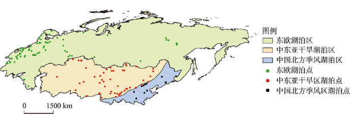 新窗口打开|下载原图ZIP|生成PPT
图1研究区范围及主要研究地点
Fig. 1Map showing the lake sites selected in this study
湖泊资料来源于2个古湖泊数据库:苏联和蒙古国古湖泊数据库(FSUDB.2)[6]以及中国晚第四纪古湖泊数据库(第二版)(CLSDB.2)[7]。数据库中湖泊水位变化是建立在逐个湖泊钻孔(剖面)沉积特性(如沉积物岩性、孢粉、硅藻组合等)、流域地貌特征以及考古资料等的综合分析和判识之上。然而,由于不同湖泊的大小和形状不同,每个湖泊的储水量和变幅也会有所差异,不同地质证据所揭示的湖泊水位变化也不尽一致。此外,虽然湖泊水位变化受到区域有效降水(降水—蒸发)的控制,但有些湖泊水位还受其他非气候因素(如洪水、火山活动、构造运动、流域侵蚀、人类活动等)、非直接气候因素(如冰川融水、海面升降、跨流域地下水等)的影响。为与全球其他古湖泊数据库一致,两个数据库均已尽可能系统地排除那些受非气候因素与非直接气候因素影响的湖泊水量记录,因此得出的湖泊水量变化可以较好地反映流域的降水和有效降水变化[11]。
CLSDB.2中的所有湖泊点年代均已校正为日历年龄(cal. a BP)。考虑到FSUDB.2中的湖泊点年代均为原始14C年龄,本文针对该数据库中的每一个湖泊点年代数据,采用OxCal 4.30程序校正为日历年龄,因此本文中所有时间体系均采用日历年。值得一提的是,为便于湖泊间的对比研究,本文中所采用的年代均暂未考虑其复杂的碳库效应。
FSUDB.2中收录了苏联和蒙古国境内103个湖泊的资料,CLSDB.2中收集了中国境内所有地区89个湖泊的资料。从这些湖泊中,本文排除不符合条件的湖泊点,共选用149个湖泊,包括93个苏联湖泊、10个蒙古湖泊以及46个中国北方地区湖泊(图1)。考虑到本文涉及湖泊点基本特征资料、水位重建代用指标及相关参考文献等在数据库中均有记载,因而在此不再赘述。
FSUDB.2和CLSDB.2中湖泊不同时期水位数字化等级划分主要根据沉积岩芯代用指标、湖区地貌调查以及考古信息综合汇总等。例如,如果湖泊沉积物为粉泥沉积,纹理发育,且硅藻组合中以浮游种占优势,则这一时段湖泊水位就相对较高。如果某一时期湖泊沉积物为有大量附生硅藻的沼泽沉积,则该阶段湖水位就相对较低。以内蒙古白素海为例,钻取于湖岸的岩芯资料表明[7],自960 cal. a BP以来,钻孔处缺失沉积,且顶部有现代植物根系,表明湖泊在该时期并未到达钻孔位置处,因此这一时段是白素海历史记录以来水位最低时期(即水位级别划为1,极低)。9840—5710 cal. a BP时期为泥炭层沉积,说明水位仍较低(即水位级别划为2,低)。16100—8710 cal. a BP及6730—3230 cal. a BP时期为灰绿色黏土或粉砂质黏土沉积,粒度相对较粗,且出现软体动物壳及大量的植物大化石,说明水位相对较高(此时水位级别划为3,中等)。3230—960 cal. a BP期间为灰绿色黏土沉积,粒度较细,软体动物壳数量较少且无植物大化石出现,表明该阶段为白素海水位最高时期(即水位级别划为4,高)。具体到每个湖泊的水位划分级别及依据,可参考FSUDB.2和CLSDB.2。
由于不同湖泊水位记录的详细程度不同,有的湖泊可分辨出多级变化(如6~7级甚至更多),而有的湖泊仅能区分出2~3级变化(如高、中及低水位)。为便于在不同地区湖泊之间进行比较,根据不同水位记录在整个湖泊历史中出现的频率(图2),分别在0~25%、25%~75%、75%~100%进行3级重新分类,划分为高、中、低3级水位,这3级水位信息分别数字化为3、2、1。为反映不同地区湖泊水位变化,图2给出了东欧湖区、中东亚干旱区及中国北方季风区湖泊低、中、高水位随时间变化下的百分统计。
图2
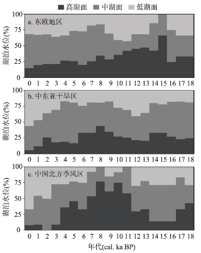 新窗口打开|下载原图ZIP|生成PPT
图218 cal. ka BP 以来不同湖区水位变化统计
Fig. 2Lake level changes since 18 cal. ka BP
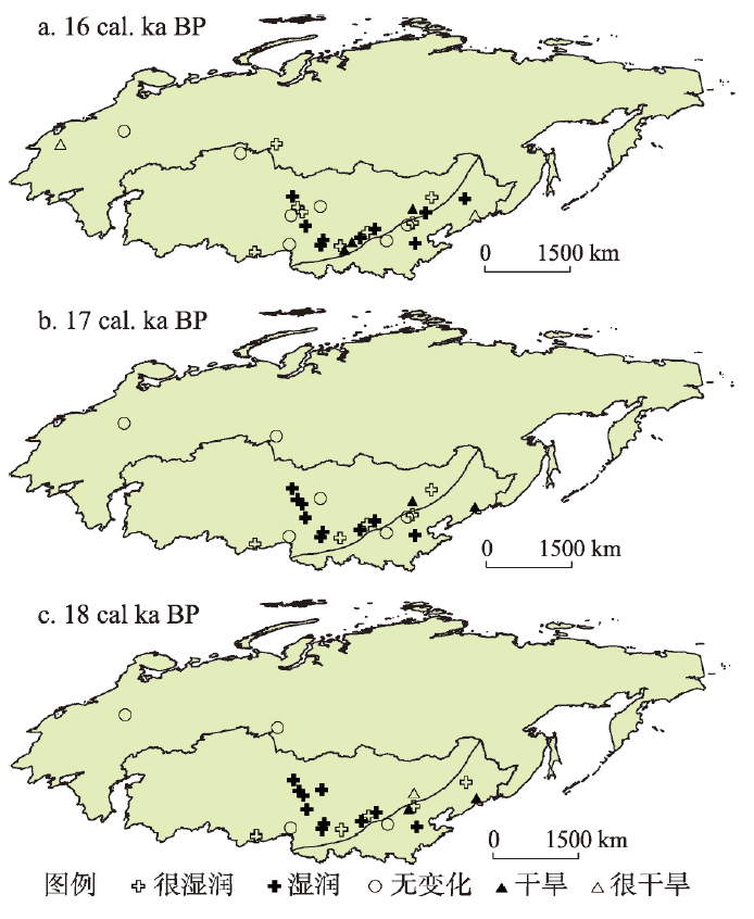
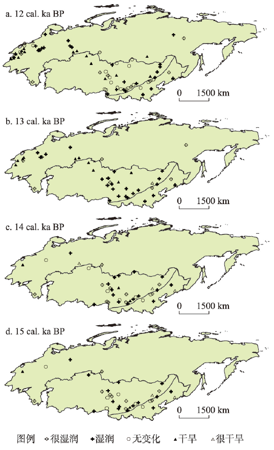
同时,为了能较清楚的分析末次盛冰期以来研究区古湖泊水量的变化过程,本文把每个湖泊数字化的3级古水位(3、2、1)表示成与现代相比的5级之差,分别代表很湿润(+2)、湿润(+1)、无变化(0)、干旱(–1)和很干旱(–2)。然后以1000年的间距确定每一个湖泊点不同时段的湿润程度(图3~图7)。这种古湖泊水位与现代水位的差值反映的是不同时期地表湿度状况的变化,这不仅可用来揭示末次盛冰期以来湖泊水量时空演变特征,还可进一步深入研究不同气候区各气候驱动力之间的内在联系。
图3
 新窗口打开|下载原图ZIP|生成PPT
图3末次盛冰期不同湖泊水量相对现代差值变化
Fig. 3Lake status, expressed as differences from present in the LGM
图4
 新窗口打开|下载原图ZIP|生成PPT
图4晚冰期不同湖泊水量相对现代差值变化
Fig. 4Lake status, expressed as differences from present during the late glacial period
图5
 新窗口打开|下载原图ZIP|生成PPT
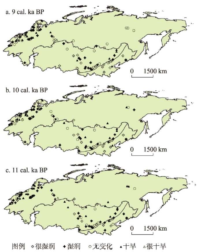
图5早全新世不同湖泊水量相对现代差值变化
Fig. 5Lake status, expressed as differences from present during the early Holocene
图6
 新窗口打开|下载原图ZIP|生成PPT
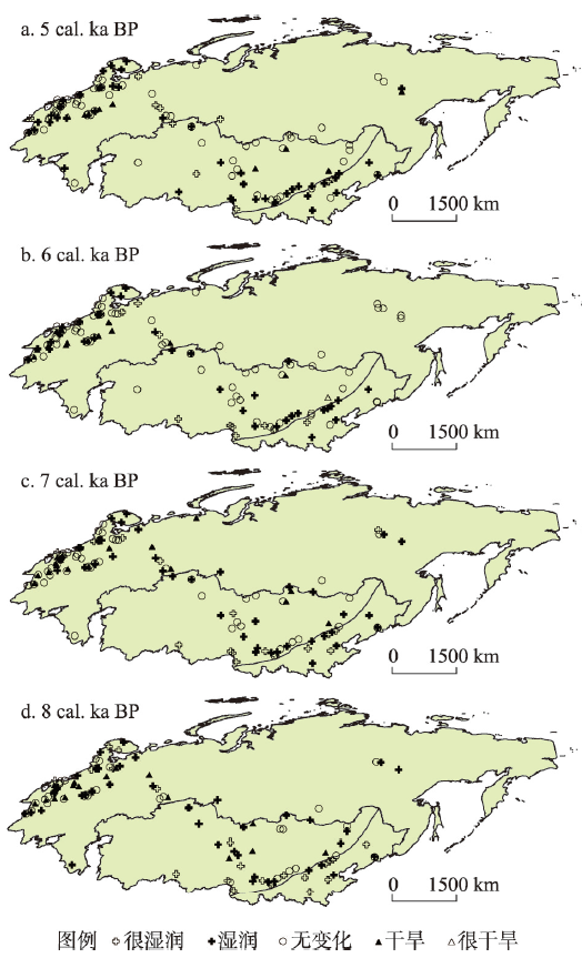
图6中全新世不同湖泊水量相对现代差值变化
Fig. 6Lake status, expressed as differences from present during the middle Holocene
图7
 新窗口打开|下载原图ZIP|生成PPT
图7晚全新世不同湖泊水量相对现代差值变化
Fig. 7Lake status, expressed as differences from present during the late Holocene
3 末次盛冰期以来不同湖区湖泊水位变化特征
18—16 cal. ka BP的末次盛冰期保留下来的地质证据表明,东欧地区有水位记录的湖泊点相对较少,且零星记录显示湖泊大多表现为中湖面状况,与现今水位类似。中东亚干旱区湖泊记录点主要集中在中国西北地区,且主要以高水位为主,偶见个别低水位湖泊,表明当时气候相对湿润,这和现今该地区气候格局形成较大反差。中国西部地区古降水量重建结果显示该时期年降水量总体比现代高100 mm以上[12],也表明该时期有效湿度较大,对应着湖泊高水位时期。中国北方季风区此时湖泊记录点相对较少,已有资料显示此时湖面呈现高低并存的状况,如华北地区的宁晋泊为高湖面,而东北地区的二龙湾则为低湖面状态,反映同一区域内不同湖泊水位波动仍存有较大差异。晚冰期(15—12 cal. ka BP),东欧地区湖泊水位记录在前期(13 cal. ka BP之前)仍较少,后期有所增加。尽管该阶段东欧湖泊以中高湖面为主,但低湖面所占比例也相对较高,表明此时不同湖泊地面有效湿度差异较大。中东亚干旱区此时湖泊记录有所增加,特别是蒙古境内开始出现湖泊记录。湖泊水量距平显示以高水位为主,反映该时期有效湿度状况仍较好,只是在晚冰期的后期低水位湖泊记录有所增加。中国北方季风区湖泊记录此时以中低湖面为主,但后期(约13 cal. ka BP)高湖面比例有所增加,预示着有效湿度状况呈逐渐增加趋势。
全新世以来不同地区的湖泊水量记录更加丰富,不仅在东欧及中东亚干旱区,中国北方季风区也有较多的记录。早全新世时(11—9 cal. ka BP),东欧地区湖泊水位发生了显著变化,总体以中低湖面为主,表明湿润状况较前期有一定程度的减弱。中东亚干旱区尽管总体反映了比现代水量大的特征,但不同湖泊所反映的干、湿状况差异显著。比如蒙古境内的Gun-Nuur湖及中亚的Borovoe湖均显示为低湖面,中国的呼伦湖、乌伦古湖等也表现为低水量特征,但中国北方非季风区大多湖泊仍以中高水位为主。这种不同地点气候所表现出的不一致性,一方面可能与不同湖泊地理位置的变化及其相应的水热组合差异有关[13,14],另一方面也可能与不同区域对气候变化的响应存在差异有关[10]。早全新世中东亚干旱区湖泊记录仍以中国北方非季风区点位为主,导致该时期整体仍表现为相对湿润的气候状况。早全新世后期(9 cal. ka BP),中东亚干旱区高水量湖泊比例显著增加。中国北部季风区在该阶段尽管夹杂零星的“无变化”和“干旱”的记录,但湖泊水量距平总体反映的是较现在湿润的状况,说明全新世早期降水总体比现在偏高。
中全新世(8—5 cal. ka BP)为距今最近的一个温暖时期,也是历来古气候模型模拟的重要时段之一[15,16]。东欧地区中高水量湖泊比例较之前明显增加,对应着相当湿润的气候条件。中东亚干旱区及中国北方季风区高水量湖泊的比例也较之前有所增加,且达到末次盛冰期以来的最高值,反映这两个地区均表现为研究时段以来最为湿润的状态。蒙古湖泊孢粉记录显示中全新世气候较为暖湿[17,18],中国区域内的其他研究也记录了相近的变化过程。如北方沙漠地区从末次盛冰期到中全新世分别向北向西撤退了大约300 km和1000 km[19,20],黄土记录也表明中全新世为全新世最适宜期[21,22],此外,中国古降雨量定量重建结果也表明,中全新世黄土高原地区降雨量增加了约100~150 mm,东北平原年降雨量高于现代约100 mm,华北地区的宁晋泊、白洋淀区域降雨量增加值约为200~400 mm[23,24],均对应于此时较湿润的气候状况。但值得注意的是,该时期中东亚干旱区及中国北方季风区湖泊水位存在一定的波动,特别是中全新世后期,高水位湖泊的范围与幅度所减少,出现一些和现代湖泊环境接近甚至比现代干旱的气候条件。
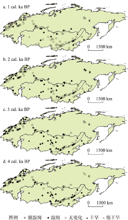
晚全新世以来(4—0 cal. ka BP),三大湖区湖泊水量资料均反映出气候类型逐渐向现代过渡的状况。图7中“无变化”的记录逐渐增加,但该时期不同地区湖泊水位变化仍存在一定差异。东欧地区湖泊记录继续增加,尽管湖泊水量距平状况较前期有一定程度的减弱,但变化幅度并不十分显著,只是到近千年才出现大量“无变化”的记录。中东亚干旱区湖泊晚全新世以来整体以低水位为主,但也存在一定波动。如约在2 cal. ka BP时期该地区湖水位呈现略微上涨趋势,表明此时有一个短时间尺度的变湿波动。其后干旱化趋势明显,气候逐渐过渡为与现代相似的情况。中国北方季风区整体表现为研究时段内湖泊水位最低时期。特别是自3 cal. ka BP开始,湖泊水量出现大幅下降,整体表现为低水量和干旱的特征,只有极少数湖泊仍然维持高水量或中等水量的特点。
4 讨论
苏联和蒙古国古湖泊数据库以及中国晚第四纪古湖泊数据库较为客观地提供了系统、规范的空间水量变化资料,在恢复该地区末次盛冰期以来的气候变化及其大气环流系统中发挥着重要作用。同时,数据库也为验证、评价和改进区域古气候模拟结果提供了一定科学依据[4],成为国际古湖泊数据库的重要组成部分。末次盛冰期和晚冰期东欧湖区的湖泊记录点相对较少,很难据此给出湖泊水量变化的确切解释。然而已有孢粉及植物大化石资料表明,由于斯堪的那维亚冰盖的扩张导致欧洲反气旋强盛以及劳伦冰盖的存在导致西风带南移,盛冰期时苏联大部为干冷气候[25]。全新世初期,东欧湖区总体表现为较干旱的气候,但西伯利亚东西两侧气候状况有所不同。东部显示了逐渐向湿润过渡的过程,而西部广大地区则一直比现代干旱。前者的湿润可能与斯堪的那维亚冰流的逐渐消退有关,而后者的干旱则可能主要由全新世初期夏季辐射的增加导致西伯利亚中部和西部的热高压比现在强势导致[26,27]。自8 cal. ka BP以后,东欧湖区东部湖泊水量出现显著增加,反映此时来源于夏季北欧反气旋东翼的气旋气流增强[26]。同时,西伯利亚地区的湖泊也出现比现代潮湿或与现今类似的水位状况(图6),可能为夏季亚洲季风渗透的结果[26]。晚全新世,湖泊资料显示了一个从先前相对湿润逐渐过渡到现代的气候类型。
来自中东亚干旱区的湖泊资料清楚地显示了高湖面发生在末次盛冰期,晚冰期时湖泊水位有所下降,全新世早期又逐渐上升,并于中全新世达到最高值,现代的湖面是18 cal. ka BP以来的最低阶段(图2)。冰期时,由于北极冰盖扩张以及东亚夏季风萎缩,使得北半球的西风气流全年强盛且西风带位置较现在南移,气候表现为冷湿,因而该地区此时湖面较高[5, 28]。同时,西风带的南移还可能造成地中海地区气候表现为冷湿而非现在的冬湿夏干,于是导致在空间上中东亚干旱区可能与地中海地区高湖面连成一带[29]。再者,由于冰期时温度较低,使得蒸发受到限制,从而有利于湖区有效降水增加,水位上升。有研究表明冰期时北半球中纬度地区气温平均下降约6~7 ℃[30],据此估算的水面蒸发量下降约30%[31]。晚冰期时,该地区仍保持高湖面特征,只是在晚冰期末期出现较多和现代水量类似的湖泊点,表明前期西风带位置的北移幅度和强度变化并不十分显著,冬季风仍相当强盛,但后期冬季风范围及强度可能呈现减弱趋势。进入全新世,中东亚干旱区大多数湖泊在早全新世表现为较为湿润的状态,在中全新世表现出最为湿润的状态。轨道参数变化引起的北半球太阳辐射变化可能是此时东亚夏季风增强并向西北内陆深入,进而导致大部分湖泊水位较高的重要原因[32,33]。从其他资料来看,此时孢粉资料显示中国东部地区的植被带曾整体向北迁移[31],腾格里沙漠南部边界曾向北退缩20 km[33],现在为荒漠草原的蒙古西北地区当时也被森林覆盖[17]。与此同时,东亚区域中全新世GCM的模拟结果也表明,该时段中国西北内陆、蒙古高原湖区降水均有显著增加[15]。全新世后期,随着季风区萎缩接近于现代环流形势,该地区湿润程度逐渐降低,但在2 cal. ka BP前后湿度略有增加,这可能与新冰期的降水增加以及温度下降有关。2 cal. ka BP 以后逐渐转向现代气候。
近来关于中东亚干旱区末次盛冰期特别是全新世以来环境变化的研究较多[10, 28, 34-39],然而对于该地区气候变化过程仍存在一定的争议。如安成邦等[10]通过中东亚干旱区8个湖泊全新世以来的半定量集成研究分析了该地区的湿度变化,认为全新世以来该地区经历了干旱的早全新世、湿润的中全新世以及湿润程度逐步降低的晚全新世(但比早全新世湿润),也即符合全新世气候变化的西风模式[34]。郭超等[38]对中国西北干旱区湖泊的研究也显示该地区气候表现为早中全新世干旱、中晚全新世相对湿润的变化过程,并且认为该地区全新世以来的气候变化不能仅用亚洲季风的深入来解释,而更多的是受西风环流、太阳辐射强度、全球冰量和青藏高原这些全球性的气候因素影响。这些均与本文所得出的该地区全新世气候变化特征有所差异。我们推测这种分歧在一定程度上与不同研究所选湖泊点不同有关,也可能与测年方法及沉积分辨率、气候代用指标的敏感性以及适用程度等不同有关。由于气候变化往往呈现出显著的区域差异性,因此,未来还需要在该地区寻找更多可靠的沉积记录来进行验证,同时也需要更多的古气候模拟和湖泊能量与水量模拟等的综合定量重建来准确模拟湖泊的演化过程。
中国北方季风区末次盛冰期及晚冰期湖泊记录点相对较少,已有资料显示此时湖面总体以低水位为主,这可能与冬季风强盛而水汽来源较少有关[5]。已有地质记录也表明,末次冰盛期时中国北方大部分地区呈现出荒漠草原或干草原的环境状况[20, 40-41]。在晚冰期后期,随着冬季季风强度减弱,该地区有效湿度状况有所增加(图2)。进入全新世后,随着北半球夏季太阳辐射增强,东亚大陆夏季温度升高、海陆热力差异加大,导致东亚夏季风增强,气候转暖,湖泊开始扩张,水位升高[42]。特别是在中全新世,该地区进入气候最适宜期,气候温暖湿润,丰沛的降水使华北地区湖泊扩张,湖面扩大。此时的大陆泽—宁晋泊、白洋淀—文安洼和七里海—黄庄洼三大湖泊洼地群可能彼此相连为统一的大湖群[3],东北地区也表现为湿润状态[43]。晚全新世以来,在太阳辐射活动减少导致降水下降以及温度升高、大气辐射和短波辐射增强造成湖泊蒸发加剧的双重作用下[44],本区结束了全新世大暖期,气候逐渐干旱,且湖泊水位为末次盛冰期以来最低的时期。需要指出的是,晚全新世以来,湖泊水位的下降除了与气候变化有关外,人类活动在该阶段可能也发挥了一定作用[3, 45-46]。
尽管目苏联和蒙古国古湖泊数据库以及中国晚第四纪古湖泊数据库中均收录了大量湖泊水位记录,为客观反映区域大气降水和有效湿度提供了地质证据,但在与不同研究的对比时仍存在差异[10, 34, 38],同时和一些古气候模拟结果也存在一定分歧[16, 47]。这除了与湖泊自身特征(地理位置、水文特征等)及其对气候变化的响应特点有关外,还可能与本文所用数据库本身存在的一些不足有关。首先,尽管数据库中已有的湖泊水位记录较多,但这些点位分布并不均匀,如俄罗斯东部及蒙古南部地区湖泊点位较少,分布较散,这在一定程度上制约了利用湖面变化研究相应的气候时空变化及其机制。其次,本文所采用的苏联和蒙古国古湖泊数据库的编撰建立在1996年以前的资料,这些资料相对偏老,部分湖泊测年精度以及水位变化指标选取等方面可能存在一定误差,导致对最终的古气候解释结果造成偏差。最后,尽管我们对文中所有湖泊年代进行了日历校正,但并未考虑各个湖泊沉积物碳库效应所带来的年龄误差,因而有时难以区分利用这些记录重建的气候时空变化是真实存在的还是仅仅由年龄误差引起的,要搞清楚不同地区湖泊空间格局变化及其动力过程未来仍需做大量的研究工作。
5 结论
来自欧亚大陆中北部地区149个湖泊水位变化的研究结果表明,不同区域末次盛冰期以来可能经历了不同的气候变化过程。东欧地区湖泊基本表现为干旱的早全新世及相对湿润的中晚全新世,但东西部地区湖泊在气候变为湿润的时间和强度上有所差异。具体而言,东欧东部地区的湿润气候与斯堪的那维亚冰流的逐渐消退以及夏季北欧反气旋东翼的气旋气流增强有关,而西部的西伯利亚广大地区则与夏季亚洲季风的渗透有关。中东亚干旱区冰期内可能受西风带降水及低温低蒸发影响而相对湿润,而全新世由于夏季风深入内陆导致气候也较湿润,但晚全新世气候出现相对干旱的状况。中国北方季风区全新世可能主要受到东亚季风的影响,湿润期主要发生在早中全新世,但是不同湖泊有所差异。然而,这只是依据现有的湖泊资料得出的一个粗略的区域气候变化模式。这个模式的准确度如何,未来仍需相关地区更多高分辨率的湖泊记录来证实,也需要更多相关的气候模拟研究结果来证实或证伪。参考文献 原文顺序
文献年度倒序
文中引用次数倒序
被引期刊影响因子
[本文引用: 1]
[本文引用: 1]
DOI:10.18307/2009.0301URL [本文引用: 1]
[本文引用: 1]
[本文引用: 3]
[本文引用: 3]
DOI:10.18307/1997.0301URL [本文引用: 2]
[本文引用: 2]
DOI:10.18307/2005.0106URL [本文引用: 4]
[本文引用: 4]
[本文引用: 4]
[本文引用: 5]
[本文引用: 5]
[本文引用: 1]
[本文引用: 1]
[本文引用: 1]
[本文引用: 1]
DOI:10.18307/2009.0303URL [本文引用: 5]
[本文引用: 5]
DOI:10.1016/0277-3791(93)90079-2URL [本文引用: 1]
[本文引用: 1]
[本文引用: 1]
DOI:10.1016/S0033-5894(02)00020-0URL [本文引用: 1]
DOI:10.1016/S0031-0182(01)00465-5URL [本文引用: 1]
[本文引用: 2]
[本文引用: 2]
DOI:10.1175/JCLI-D-11-00231.1URL [本文引用: 2]
DOI:10.1016/j.aeae.2009.03.001URL [本文引用: 2]
DOI:10.1016/S0012-821X(99)00171-5URL [本文引用: 1]
[本文引用: 1]
[本文引用: 2]
[本文引用: 2]
[本文引用: 1]
[本文引用: 1]
[本文引用: 1]
[本文引用: 1]
[本文引用: 1]
[本文引用: 1]
[本文引用: 1]
[本文引用: 1]
DOI:10.1007/s003820050278URL [本文引用: 1]
[本文引用: 3]
[本文引用: 3]
DOI:10.1006/qres.1996.0016URL [本文引用: 1]
[本文引用: 2]
[本文引用: 2]
DOI:10.1007/BF02884684URL [本文引用: 1]
[本文引用: 1]
DOI:10.1126/science.191.4232.1131URL [本文引用: 1]
DOI:10.1016/S0921-8181(98)00036-8URL [本文引用: 2]
DOI:10.1126/science.241.4869.1043URL [本文引用: 1]
[本文引用: 2]
[本文引用: 2]
[本文引用: 3]
[本文引用: 3]
DOI:10.1016/j.quascirev.2007.10.017URL
DOI:10.1016/j.quaint.2007.12.002URL
DOI:10.11820/dlkxjz.2014.06.007 [本文引用: 2]

Environmental changes recorded by lake sediments have been one of the major tools for reconstructing the palaeoenvironment and palaeoclimate in many parts of the world. Spatial and temporal patterns of humidity changes during Holocene have been reconstructed based on the compilation of recently published paleoclimate records from the inland areas of China. The climate of this region is sensitive to large-scale climate forcing. We divided China's inland areas into the arid northwestern region, the East Asian monsoon-margin region and the Qinghai-Tibet Plateau according to the amount of precipitation and natural zones. Sediment records from 30 lakes with reliable chronologies and robust proxies were selected to reconstruct dry-wet conditions based on a three-class ordinal wetness index (dry, sub-humid, humid) with assigned scores from dry to wet periods at individual sites for 500-year time slices. Then we formulated the regional dry-wet index, which may represent the average change of the regional dry-wet conditions. The proxies used in these records include pollen assemblages, oxygen isotope ratio (δ<sup>18</sup>O), organic matter and carbonate content (mainly pollen assemblages) data. The results of our synthesis show that the moisture conditions have experienced diverse changes over the Holocene in different regions of china's inland areas. Arid climate prevailed during the early Holocene, and relatively wet climate characterized the middle and late Holocene in arid northwestern China. But the climate change differed from place to place—the further into the west, the drier the climate during the early and middle Holocene and wetter in the late Holocene. In the East Asian monsoon-margin region, drier climate also prevailed during the early Holocene, and a wetter period may had occurred in the mid-Holocene, then the climate underwent another transition—it was driest in the late Holocene. In the Qinghai-Tibet Plateau, the wettest period may had occurred in the early and mid-Holocene, then the climate became dry gradually, but there was a tendency of wetness in late Holocene. The wet periods in eastern Qinghai-Tibet Plateau were longer than in the central and western regions. The comparative analysis reveals that the climate may have been mainly controlled by westerly circulation in arid northwestern China. But there were differences among the lake records in the timing of the beginning and end of the dry or humid periods as well as the intensity of the dry or wet conditions, which may be related to the strength of the Asian monsoon in the early Holocene and the influence of westerly circulation in the late Holocene. Furthermore, the insolation, global ice-sheets and topography of the Tibetan Plateau may have played important roles in controlling climate change in this area. The climate change in the East Asian monsoonmargin region is mainly influenced by the East Asian monsoon, which has also been recorded by the loess and desert deposits. The moisture conditions in the Qinghai-Tibet Plateau may have been controlled by the Indian monsoon, and the wetness in the early Holocene may be related to the strengthening of the Indian monsoon. Around 4 ka BP, a significant dry event commonly occurred in China's inland areas, which may be a global dry event that may have resulted in the decline of some ancient civilizations in the whole world.
[本文引用: 2]
DOI:10.1016/j.quascirev.2016.06.002URL [本文引用: 1]
DOI:10.1016/j.quaint.2014.06.065URL [本文引用: 1]
DOI:10.1016/j.quaint.2013.10.039URL [本文引用: 1]
DOI:10.1016/0033-5894(78)90064-9URL [本文引用: 1]
DOI:10.1016/j.epsl.2016.09.052URL [本文引用: 1]
[本文引用: 1]
[本文引用: 1]
[本文引用: 1]
[本文引用: 1]
DOI:10.18307/2007.0505URL [本文引用: 1]
[本文引用: 1]
DOI:10.1016/j.palaeo.2011.07.003URL [本文引用: 1]
