 ,1,2, 张金茜1,2, 刘志锋1,2, 黄庆旭1,2
Characteristics and progress of land use/cover change research during 1990-2018
HE Chunyang,1,2, ZHANG Jinxi1,2, LIU Zhifeng1,2, HUANG Qingxu1,2收稿日期:2020-05-28修回日期:2021-05-7
| 基金资助: |
Received:2020-05-28Revised:2021-05-7
| Fund supported: |
作者简介 About authors
何春阳(1975-), 男, 四川射洪人, 教授, 主要从事综合自然地理学、土地利用/覆盖变化和城市景观可持续性研究。E-mail:

摘要
关键词:
Abstract
Keywords:
PDF (4712KB)元数据多维度评价相关文章导出EndNote|Ris|Bibtex收藏本文
本文引用格式
何春阳, 张金茜, 刘志锋, 黄庆旭. 1990—2018年土地利用/覆盖变化研究的特征和进展. 地理学报, 2021, 76(11): 2730-2748 doi:10.11821/dlxb202111010
HE Chunyang, ZHANG Jinxi, LIU Zhifeng, HUANG Qingxu.
1 引言
土地利用(Land Use)指人类对土地的开发利用,如耕地、工业用地和商业用地等[1];土地覆盖(Land Cover)指被自然营造物和人工建筑物所覆盖的地表诸要素的综合体,如冰川积雪、裸岩裸土及道路等[2]。土地利用、土地覆盖和生态系统3部分构成的土地系统(Land System)是地球表层系统的基本组成部分[3]。土地利用/覆盖变化(Land Use/Cover Change, LUCC)不仅再现了地球表层景观的时空动态过程,而且客观记录了人类活动对地球表层的改造历程,是揭示人类活动与自然环境相互作用机理的有效途径,也是地理学进行地表综合集成研究的学科基础和前沿领域[3]。自20世纪90年代以来,LUCC研究已走过了近30年的历程。当前,随着人类社会迈入人类世,气候变化、生物多样性损失和氮循环等过程已经超过了地球系统的安全阈值,作为地表基本组成部分的土地系统也进入了潜在高风险区[4,5]。因此,及时了解LUCC研究的基本特征、存在问题和发展趋势非常必要。目前,已有不少****综述了LUCC研究进展。在国际上,Lambin等系统综述了LUCC的驱动因子[6]。Foley等全面综述了全球LUCC对粮食生产、淡水资源、森林资源、区域气候和大气质量以及传染病的影响[7]。Verburg等指出LUCC的研究焦点应该从对土地系统变化及其驱动因子的理解向如何提高土地系统的可持续性转变[8]。Long等提出了区域土地利用转型的理论模型,并论述了土地利用转型和土地管理之间的相互反馈机制[9];Liu等论述了经济转型下土地利用政策的战略性调整[10]。在国内,李秀彬首先从全球变化研究的视角,系统介绍了LUCC研究的基本内容、关键问题和研究方法[11]。蔡运龙阐述了LUCC研究的驱动力、尺度、方法及理论如何综合的问题[12]。唐华俊等综述了LUCC模型在理论、方法和实践应用等方面的进展[13]。刘纪远等从LUCC时空过程探测、驱动机理分析和宏观生态效应评价等方面综述了LUCC时空过程研究的方法进展[14]。傅伯杰等综述了土地利用变化与生态系统服务的相关研究背景、概念、方法与进展[15]。樊杰基于“人地关系地域系统”理论,论述了土地资源与区域可持续发展研究关系[16]。傅伯杰等认为系统认知土地资源既是全面、综合、深入理解人地复杂系统的知识需要,也是服务于国家生态文明建设重大战略的实际需求[17]。这些综述积极推动了LUCC研究的不断拓展和深入。但总体上看,基于文献计量方法,系统分析LUCC研究的基本特征和问题,并展望其未来发展趋势的综述还比较少见,这不利于当前LUCC研究的进一步深入和发展。
为此,本文以文献计量分析为基础,回顾了1990年以来的LUCC研究基本历程,揭示了LUCC研究特征和趋势,综述了主要研究进展,提出了LUCC研究存在的问题、主要挑战和未来发展趋势。目的在于为LUCC研究的深入发展提供借鉴和参考。
2 LUCC研究历程
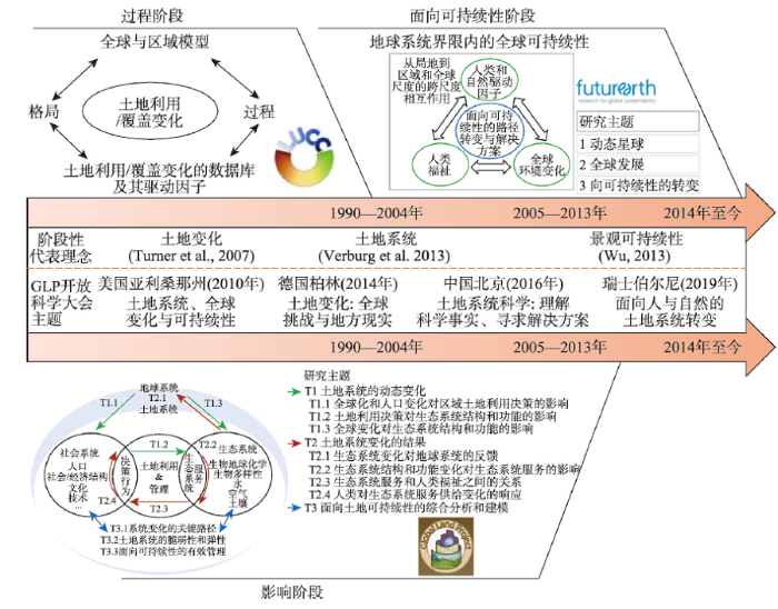
LUCC研究与该领域国际科学计划的发起密切相关,这些计划引领着LUCC研究的重点发展方向。虽然这些计划的实施成效有所差别,但是本文主要依据每个研究计划的重点内容不同将其历程分为3个阶段,分别是过程(1990—2004年)、影响(2005—2013年)和面向可持续性(2014年至今)阶段(图1)。在过程研究阶段,国际地圈生物圈计划(International Geosphere-Biosphere Programme, IGBP)与国际全球环境变化人文因素计划(International Human Dimensions Programme on Global Environmental Change, IHDP)于1995年联合发起的LUCC计划起到了纲领性作用,其核心是力图通过对人类驱动力—土地利用/覆盖变化—全球变化—区域响应—环境反馈间相互作用机制的认识,建立可预测未来土地利用/覆盖变化,评价其生态环境后果并提供决策支持的LUCC模型[11]。在该计划的推动下,LUCC研究在全球开始逐渐兴起[18]。图1
 新窗口打开|下载原图ZIP|生成PPT
图1LUCC研究历程
注:修改自文献[3]、[18]和[21]。
Fig. 1The history of LUCC research
在影响研究阶段,IGBP与IHDP于2005年共同推出的全球土地计划(Global Land Programme, GLP)扮演了引领性角色。GLP明确提出综合土地利用、土地覆盖和生态系统的土地系统概念,强调从系统分析的角度,模拟和评估全球土地系统变化的生态环境影响,认识和理解全球土地系统变化的脆弱性和弹性。2007年Turner等明确指出土地变化科学(Land Change Science)对全球环境变化和可持续性的意义[19]。2010年以“土地系统、全球变化与可持续性”为大会主题的第一届全球土地计划开放科学大会在美国亚利桑那州召开。2013年Verburg等倡导建立土地系统科学(Land System Science)理念。这都对LUCC研究在全球的进一步深入和发展起到了积极的作用[20]。
在面向可持续性阶段,国际科学理事会和国际社会科学理事会等于2014年正式推出了“未来地球(Future Earth)计划”。在该计划的推动和影响下,相关研究明确以提高全球可持续性为目标,开始重点关注不同尺度下LUCC过程、生态系统服务和人类福祉的耦合关系[21]。2013年Wu提出了景观可持续科学(Landscape Sustainability Science)的研究理念,强调以景观和区域为基础,认识和理解景观格局、生态系统服务和人类福祉的相互关系,提高全球可持续性[22]。随后,2014年、2016年和2019年连续召开3届全球土地变化计划开放科学大会,会议主题分别是“土地变化、全球挑战与地方现实”“土地系统科学:理解科学事实、寻求解决方案”“面向人与自然的土地系统转变”,进一步推动了LUCC面向可持续性的研究进程。
3 LUCC研究进展
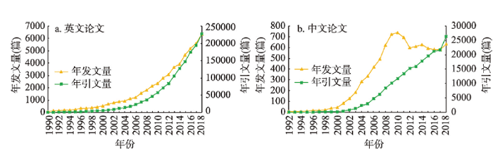
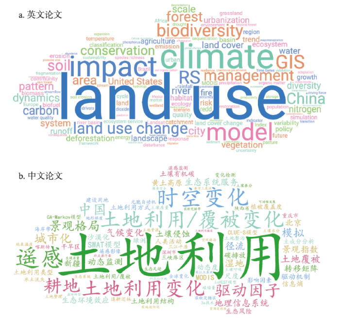
1990—2018年相关中英文论文的发文量和引文量总体上呈现快速增长趋势(图2)。其中,中文论文在2010年前后有一定下降,这与更多中国****选择将成果以英文论文发表有关。在英文论文中,前10位的高频词分别是“land use”“climate”“land use change”“impact”“management”“biodiversity”“model”“conservation”“dynamics”和“forest”。在中文论文中,前10位的高频词分别是“土地利用”“土地利用/覆被变化”“土地利用变化”“时空变化”“驱动因子”“遥感”“生态系统服务”“景观格局”“地理信息系统”和“耕地”(图3)。图2
 新窗口打开|下载原图ZIP|生成PPT
图21990—2018年LUCC论文发文量和引文量
注:2019年7月29日在Web of Science核心合集数据库和中国知网核心期刊数据库分别检索了1990—2018年发表的中英文论文;英文论文的检索式为:TS= ("land use" OR "land cover") AND TS= ("change" OR "changes") OR TS= ("forest transition" OR "agricultural land marginalization"),共计51245篇;中文论文的检索式为:SU=土地利用 OR SU= 土地覆盖 OR SU=土地覆被) AND SU=变化 OR (SU=森林转型 OR SU=农地边际化,共计9042篇。
Fig. 2Publications and cites on LUCC research from 1990 to 2018
图3
 新窗口打开|下载原图ZIP|生成PPT
图31990—2018年LUCC论文单词云
注:基于CiteSpace平台对选取的51245篇英文文献和9042篇中文文献的关键词进行词频分析,并通过WordArt制作词云图以直观表达;单词云中的字号大小表征关键词出现的频次,频次越高字号越大;颜色主要是为了直观显示和美观,无实际表征涵义。
Fig. 3Word cloud of LUCC papers from 1990 to 2018
3.1 1990—2004年的过程研究阶段
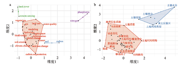
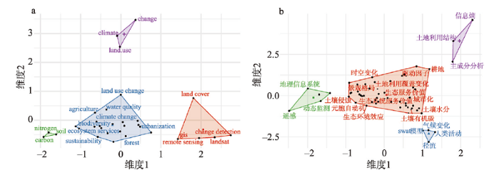
基于高频关键词的聚类分析可以看出,该阶段英文论文的研究内容主要分为5类。第1类是运用遥感技术对土地覆盖变化的动态监测;第2类涉及LUCC对氮、磷循环的影响;第3类是LUCC对土壤碳的影响;第4类是LUCC模型的建立;第5类主要涉及LUCC的生态环境效应,比如LUCC对水质和土壤侵蚀的影响(图4a)。中文论文主要是LUCC动态监测、LUCC时空变化及其驱动力分析、LUCC对土壤(侵蚀、养分、水分等)的影响研究,耕地是中文论文重点关注的土地利用类型(图4b)。被引频次方面,排名前5的英文论文主要涉及LUCC驱动力、生物多样性、气候和土壤碳等主题,被引频次超1700次。排名前5的中文论文主要是LUCC机制研究、LUCC方法研究、LUCC对生态环境影响的小尺度实例应用研究以及LUCC综述,被引频次超1000次。图4
 新窗口打开|下载原图ZIP|生成PPT
图4过程研究阶段中英文论文高频关键词的多维分析
注:基于R语言环境的Bibliometrix和Biblioshiny包制作,聚类方法为MCA(multiple corresponding analysis)。
Fig. 4Multidimensional analysis of high-frequency keywords in English and Chinese papers during the process research stage
(1)在遥感技术、分类系统和分类方法不断发展的基础上,建立和完善了覆盖全球的各种分辨率的LUCC基础数据。典型的主要包括美国马里兰大学的UMD(University of Maryland)数据[23]、美国地质调查局的IGBP DISCover(International Geosphere-Biosphere Program's Data and Information System Cover)数据[24]、欧盟联合研究中心的GLC2000(Global Land Cover 2000)数据[25]、美国波士顿大学的MODIS(Moderate Resolution Imaging Spectroradiometer)数据[26]以及欧洲航天局的GlobCover数据和Climate Change Initiative-Land Cover(CCI-LC)数据等[27,28]。
(2)积极分析LUCC驱动力。LUCC驱动力包括自然驱动力和社会经济驱动力两方面。自然驱动力主要指气候、土壤和水文等[29]。社会经济驱动力可以分为直接驱动力和间接驱动力。直接驱动力是指对土地产品的需求、对土地的投入、城市化程度、土地利用的集约化程度、土地权属、土地利用政策以及对土地资源的保护态度等。间接驱动力主要包括人口变化、技术发展、经济增长、政治与经济政策、富裕程度和价值取向等方面[30]。LUCC是自然和社会经济驱动力共同作用的结果。通常在短时间尺度上,社会经济驱动力快速而显著,而自然驱动力主要表现为累积性效应[29]。
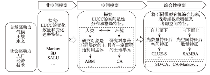
(3)发展了一系列LUCC模型。LUCC模型是认识和理解LUCC过程及其驱动机制、预测LUCC趋势、支持LUCC决策的重要工具。这一阶段的LUCC模型主要包含非空间模型、空间模型和综合性模型3类(图5)。非空间模型主要量化土地利用/覆盖变化的速率和数量特征,比如马尔可夫(Markov)和系统动力学(System Dynamics, SD)模型等[31,32]。空间模型主要表达土地利用/覆盖变化的空间格局特征[13]。有的空间模型侧重表达“人类—环境”系统中人类行为,以不同层次的土地利用主体为基本模拟单元,比如基于智能体模型(Agent-based Model, ABM)等[33,34]。有的空间模型则侧重反映“人类—环境”系统中环境适宜性和约束性,以不同分辨率的土地单元为基本模拟单元,比如元胞自动机(Cellular Automata, CA)模型等[35]。综合性模型是综合非空间模型和空间模型进行多尺度模拟的一类模型。这一类模型通常先从宏观尺度上确定某一区域的LUCC总体速率和数量特征,然后将这些宏观尺度的土地利用总需求变化向低层次的空间单元逐渐进行配置,一直到最小的微观地理单元,比如CLUE-S(Conversion of Land Use and Its Effects at Small Regional Extent)模型和LUSD(Land Use Scenarios Dynamics)模型[36,37]。也有的综合模型主要从微观尺度出发,先模拟分析特定的土地利用决策者的土地选择行为和过程,再通过尺度推绎反映宏观的LUCC特征,比如SAMBA模型[38]。
图5
 新窗口打开|下载原图ZIP|生成PPT
图5LUCC模型的发展历程
Fig. 5The history of LUCC model
3.2 2005—2013年的影响研究阶段
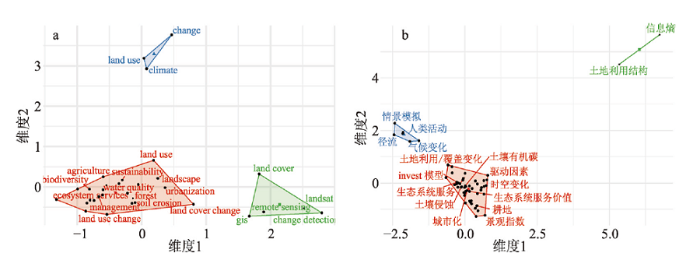
基于高频关键词的聚类分析可以看出,该阶段英文论文的研究内容主要分为6类。第1类是土地利用变化对气候的影响;第2类涉及LUCC对土壤碳、氮的影响;第3类是LUCC对生物多样性的影响;第4类是LUCC对水质的影响;第5类是LUCC对生态系统服务的影响;第6类是运用遥感和地理信息系统技术对土地覆盖变化进行监测(图6a)。中文论文主要涉及LUCC动态监测、LUCC时空变化及其驱动力分析、LUCC模型模拟、LUCC对土壤的影响、LUCC对径流的影响以及LUCC对生态系统服务价值的影响(图6b)。被引频次方面,排名前5的英文论文聚焦LUCC影响研究,重点关注LUCC对气候影响,被引频次超2400次。排名前5的中文论文主要是LUCC模型模拟、LUCC机制分析以及LUCC对土壤质量的影响研究,被引频次超440次。图6
 新窗口打开|下载原图ZIP|生成PPT
图6影响研究阶段中英文论文高频关键词的多维分析
Fig. 6Multidimensional analysis of high-frequency keywords in English and Chinese papers during the impact research stage
(1)揭示了LUCC对自然生境和生物多样性的影响。首先,LUCC主要通过生境丧失、退化和破碎化3种方式对自然生境产生影响[39]。研究表明,大约39%的陆地生境已转变为耕地或建设用地,还有37%的陆地生境已出现退化和破碎化[40]。其次,LUCC主要通过影响自然生境进而成为生物多样性损失的主要驱动因子[41]。研究表明,随着生境的减少,全球大约有20%~35%的哺乳动物、爬行动物和两栖动物面临着灭绝的风险[42,43]。还有研究表明,至2070年全球物种的适宜生境将显著减少,土地利用变化将造成大约1700个物种濒临灭绝[44]。特别是对于陆地生态系统而言,土地利用变化可能将会对生物多样性产生最大影响,其次是气候变化、氮沉降、生物交换和CO2浓度的升高[45]。
(2)评估了LUCC对大气的影响,主要表现在对区域气候和大气质量2个方面。LUCC可以通过对净辐射的影响改变区域气候,也可以通过影响降水在土壤水分、蒸散和径流间的分配过程改变区域气候[7]。比如,热带地区的土地覆盖变化很大程度上通过改变水分平衡来影响气候,而温带地区的土地覆盖变化主要通过对地表辐射的影响来改变气候[46]。在某些情况下,LUCC对气候的影响甚至可能超过温室气体的贡献[47]。特别是城市化对区域气候的影响。例如,Kishtawal等分析了印度城市化对降水的影响,发现城市化速度越快的地区强降水事件频率增加的趋势越明显,并且城区与非城区相比可能具有更大的降水速率[48]。Kim等根据韩国气候记录开展的研究表明,1954—2008年城市化对升温起到主要作用,其作用大于温室效应[49]。同时,LUCC与大气质量紧密关联[50],LUCC既可以通过改变气体的排放量影响大气质量,又可以通过影响反应速率、传输和沉积的大气条件来改变大气质量[7]。
(3)评估了LUCC对土壤的影响。LUCC不仅可以改变土壤的物理和化学性质,也可以改变土壤生态系统的组成,从而影响土壤质量和土壤肥力,最终影响土地生产力[51,52]。例如,森林向草地和农田的转变会导致地上生物量的减少,进而降低土壤碳的输入,同时由于农田的耕种,会进一步引起土壤碳的减少[53]。再者,土地利用变化也对土壤养分含量(比如氮、磷含量等)产生重要影响。例如,随着农业活动的扩张,人类对农业用地的利用程度进一步加剧,化肥、农药的使用量快速增加,这使得土壤生态系统的人为养分输入远远超过自然养分来源,最终可能导致土壤退化[54,55]。更为严重的是,土地利用变化还会导致土壤侵蚀、土壤荒漠化等土壤环境问题。比如,中国黄土高原在经过人类社会长期的农耕开垦利用后,自然森林和草原植被几乎破坏殆尽。根据“中国水土流失与生态安全综合科学考察”,总面积64万km2的黄土高原,土壤侵蚀面积达39万km2,土壤侵蚀模数高于15000 t/(a·km2)的剧烈水蚀面积为3.67万km2,占全国同类面积的89%[56]。另有观测数据表明,20世纪70年代黄河输沙量的90%来自黄土高原[57]。
(4)评估了LUCC对水循环和水资源的影响。水循环方面,LUCC既可以通过植被冠层截留、根系吸收和气孔蒸腾直接影响水循环,也可以通过植物群落的垂直结构和水平结构间接影响水循环,主要包括蒸发、径流、入渗和地下水补给等[58]。研究表明森林砍伐造成植被冠层截留、蒸发和入渗的能力降低,地表径流增加,洪水风险加剧[59]。还有研究表明,在全球尺度上土地覆盖变化造成陆地蒸发量减少约5%,径流增加7.6%[60]。水资源方面,LUCC主要对水量和水质产生影响。比如,城市扩展造成不透水面的增加,使得入渗能力下降,产流增加[61]。另外,与土地利用密切相关的用水需求也会直接影响水资源量,特别是农业灌溉。研究表明全球取水量总计约3900 km3/a,消耗性水量(不再返还到流域)大致为1800~2300 km3/a,其中仅农业便高达约85%[62]。随着人类用水需求的逐步提高,很多区域的地下水水位快速下降[63,64]。不仅如此,土地利用变化还是造成水质发生变化的重要原因[65],尤其是农业用地方式的不合理,加之农田管理模式的不恰当,会导致过量氮、磷经径流冲刷形成非点源污染,影响河流水质[66]。
3.3 2014—2018年的面向可持续性阶段
该阶段英文论文的聚类结果与影响研究阶段比较相似,不同之处是该阶段对LUCC与生态系统服务之间关系的研究更加全面和深刻,并且重点关注可持续发展问题,尝试从土地利用优化和管理的角度实现区域可持续性(图7)。中文论文在延续影响阶段研究内容的前提下,更加关注不同情景下LUCC对径流的影响,城市化进程中的景观、生态、环境效应,以及LUCC对生态系统服务的影响研究(图7)。被引频次方面,排名前五的英文论文高度关注全球尺度,聚焦LUCC对生态系统服务和生物多样性的影响,以及土地覆盖产品的研制,被引频次超590次。排名前5的中文论文主要是LUCC机制分析以及LUCC对生态系统服务的影响研究,被引频次超180次。图7
 新窗口打开|下载原图ZIP|生成PPT
图7面向可持续性阶段中英文论文的高频关键词的多维分析
Fig. 7Multidimensional analysis of high-frequency keywords in English and Chinese papers during the sustainability research stage
(1)把LUCC过程嵌入人地系统模型中。人地耦合系统指人类和自然相互作用形成的系统,强调人地关系、自然与人文要素的综合。人地耦合系统模型可以描述人类系统和地球系统之间的反馈关系[67]。一般情况下,温室气体排放量或浓度、CO2排放量或浓度以及LUCC是人类系统进入地球系统的关键要素,温度、降水和生态系统生产力是地球系统进入人类系统的关键要素[68,69,70,71]。人地耦合系统模型通过单向或双向耦合的方式将人类系统和地球系统联系起来。当前,单向耦合的人地系统模型较多,双向耦合的人地系统模型较少。代表性的单向耦合模型主要有CNRM-CM/IMAGE(Centre National de Recherches Météorologiques-Coupled Models /Integrated Model to Assess the Global Environment)和GOLDMERGE(Complexity Ocean-Atmosphere-Sea Ice Model/Model for Evaluating the Regional and Global Effects)等[72,73]。代表性的双向耦合模型主要是iESM(integrated Earth System Model)和MIT IGSM(MIT Integrated Global System Model)[68, 74]。以iESM模型为例,它将综合评估模型(Global Change Assessment Model, GCAM)和地球系统模式(Community Earth System Model, CESM)耦合在一起,通过CO2排放量、LUCC和生态系统生产力实现人类系统和地球系统的相互联系[74]。Calvin等基于iESM模型分析了RCP 4.5和RCP 8.5情景下人类系统和地球系统之间不同的反馈特征[75]。
(2)揭示了LUCC对生态系统服务的影响。LUCC通过直接或间接地对生态系统格局与过程产生影响,改变着生态系统服务的提供能力[15]。千年生态系统评估(Millennium Ecosystem Assessment, MA)报告指出,土地覆盖变化是过去50年导致陆地生态系统服务变化的最重要的两个直接驱动力之一(另一个为新技术的应用),尤其是自然生态系统向农田生态系统的转化[76]。生物多样性和生态系统服务政府间科学政策平台(Intergovernmental Science-Policy Platform on Biodiversity and Ecosystem Services, IPBES)全球评估报告也指出,土地利用变化是全球尺度上影响陆地和淡水生态系统的最主要直接驱动因子[77]。首先,LUCC对供给服务(粮食、淡水和能源等)产生影响。以LUCC影响粮食生产为例,随着世界人口的持续增长,预计到2050年粮食需求将增加50%~80%[78]。研究表明,近几十年来耕地面积略有增加,但人均耕地面积呈减少趋势,从1973年的0.34 hm2/人下降至2008年的0.23 hm2/人[79]。满足未来粮食需求的战略包括提高现有土地的生产力以及增加粮食生产用地[80,81]。然而,土地退化还在持续,土地资源十分紧缺,协调土地利用、粮食生产和农业之间的关系面临着巨大挑战[79,82]。其次,LUCC对调节服务(气候调节、洪水调节和碳固持等)产生影响。以LUCC影响气候调节为例,联合国政府间气候变化专门委员会(IPCC)特别报告详细阐述了LUCC与气候变化之间的复杂关系,指出在RCP 8.5情景下,全球土地覆盖变化产生的生物地球化学效应将造成未来气候变暖,升温范围在0.04~0.35 ℃之间,而生物物理效应对全球气候的影响还未明确,可能导致升温,也可能导致降温[83,84,85,86]。多数研究还发现,森林对气候调节服务的贡献最大,其次是其它自然生态系统,再次是农业生态系统[87,88]。LUCC通过两种可能的途径对文化服务产生影响。一种是直接影响,例如道路修建和运营使得自然或文化景观的可达性增加,对更多消费者享受文化服务,实现其文化价值具有正面效应;另一种是间接影响,例如LUCC对大气环境产生影响,进而对自然或文化景观的赋存环境产生作用[89]。此外,LUCC也会对多种生态系统服务之间的关系产生影响[15]。比如在干旱半干旱地区,LUCC下的农业生产和调节服务(比如碳固持、土壤保持服务等)之间常常存在一定权衡关系[90,91,92,93]。
(3)开始重视LUCC对人类福祉的影响研究。人类福祉的概念众多,其中,MA报告提出的概念被广泛应用于生态系统服务和人类福祉研究中。MA报告指出,人类福祉包括5个要素:维持高质量生活所需要的物质、健康、自由权和选择权、良好的社会关系和安全[76]。LUCC可以改变生态系统服务的提供能力,从而影响人类福祉[15]。但关于LUCC、生态系统服务和人类福祉三者关系的定量研究还处于起步阶段[92]。例如,Xu等分析了土地利用强度对生态系统服务(粮食生产、土壤保持和气候调节)和人类福祉(特别是在生活水平和粮食安全方面)的影响,发现土地利用强度与生态系统服务和人类福祉之间的关系密切[93]。
(4)开始面向可持续性的土地利用优化和管理研究。可持续发展是必要的,而非一种选择[22],它的最终目的是提高人类福祉,即满足当代人和后代人的物质和精神需求[94]。生态系统服务被普遍认为是连接自然资本与人类福祉的重要桥梁[95],它为可持续发展研究提供了一个可操作的概念框架[94]。以生态系统服务为核心是面向可持续性的土地利用优化和管理研究的主要途径。例如,Wu等以黄土高原的延河流域为例,基于生态系统服务评估开展土地利用优化研究,提出一种流域最适宜的土地利用优化方案,不仅可以保证生态系统服务供给能力的提升,也可以满足一定程度上社会经济活动的需求[96]。Zhang等模拟了2013—2040年间京津冀城市群在不同生态系统服务保护情景下的城市景观动态变化,以维持和保护关键生态系统服务为目标来寻找最佳的景观规划方案[97]。
4 存在问题与主要挑战
4.1 现有研究存在的问题
LUCC研究仍在理论、数据、方法、内容和应用上存在一些瓶颈问题。在理论上,LUCC研究还需要多学科的理论支撑。可持续发展是LUCC研究的最终目标,为实现这一目标,LUCC研究的对象呈现系统化趋势,例如区域系统、陆表系统、土地系统等。一旦研究对象是某一系统,科学问题则必然综合且复杂,涉及多学科。因此,如何基于多学科的理论框架完善LUCC研究体系是值得思考的问题[98]。在数据上,多源土地覆盖数据的融合存在不足。目前,单一的土地覆盖数据产品已不能满足LUCC研究日益深入的应用需求,通过数据融合可以解决不同数据之间分类系统的不兼容问题,并在一定程度上提高数据的精度。因此,如何通过有效的融合方法,综合利用当前存在的土地覆盖数据及相关辅助信息,发挥各数据的优势特点,获得时空连续、精确估算的融合结果,是亟待解决的问题[99,100]。在方法上,首先,LUCC模型的验证存在不足,如何对LUCC模型进行科学地验证以保证其可靠性是需要解决的重要难题[101]。其次,LUCC模型与生态过程模型的耦合程度不够。模型是揭示LUCC对土壤、气候、水文、生物地球化学循环等诸多自然要素影响的有效方法,但现有模型大多是松散耦合,很难动态地表达LUCC与生态过程之间的作用关系[102]。因此,构建紧密耦合的LUCC与生态过程综合模型是一个需要迫切解决的问题。在内容上,对不同LUCC下的生态系统服务与人类福祉之间关系的研究还很不够。生态系统服务和人类福祉之间的关系是LUCC研究面向可持续性的焦点问题,但两者关系的复杂性使其成为一个难点领域[103]。在应用上,LUCC研究成果如何应用于区域的决策管理仍面临着问题。目前,流域被认为是一个理想的区域单元,以流域为单元的LUCC研究成果也很丰富,但将其真正地应用于流域可持续管理的研究还很缺乏。此外,LUCC研究成果在当前国土空间规划中的应用也还不足。4.2 主要挑战
在当前国际可持续科学快速发展,国内生态文明建设日益深入的背景下,LUCC研究正面临理论、方法和应用上的巨大挑战。在理论上,LUCC研究正面临在可持续科学研究框架下,如何响应联合国2030年可持续发展目标的挑战。可持续科学是“研究自然和社会之间动态关系的科学”,其目的是为可持续发展提供理论基础和技术手段[94, 104]。在联合国提出的17项可持续发展目标中,消除饥饿、良好的健康与福祉、清洁饮水和卫生设施、可持续城市和社区、气候行动以及陆地生物等目标与LUCC紧密相联[105,106]。如何在可持续科学的框架下,以联合国可持续发展目标为导向,将研究对象向全要素跨尺度的LUCC系统研究迈进,研究内容向面向可持续的LUCC优化管理拓展,已成为新时代LUCC研究面临的重要挑战。同时,当前以大数据、云计算和人工智能为代表的新兴技术正方兴未艾,深度融合。大数据通常是指“在用户可接受的时间范围内,使用普通设备不能获取、管理和处理的数据集”,具有体量大、类型多、真实性和变化速度快4项基本特征[107,108]。大数据为理解LUCC过程和可持续发展的关系提供了新的机遇[109]。以人工神经网络、贝叶斯网络和深度学习等机器学习算法为代表的人工智能技术以及以云计算为代表的分布式网络并行计算与存储平台的快速发展与应用,为分析和挖掘大数据提供的海量信息提供了两大关键支柱[110]。在新技术的加持下,虚拟地理环境技术蓬勃发展[111,112]。这些新的数据和技术为深入理解LUCC过程、影响和可持续性之间的相互作用机制,开展全要素跨尺度的土地系统优化模拟与仿真带来了新的机遇,同时也带来了巨大的挑战。如何有效整合这些新兴数据和技术,发展新的LUCC研究方法体系,已经成为LUCC研究向新时代迈进过程中亟待解决的问题。
此外,国土空间规划是对国土空间有效保护、有序开发、高效利用和高品质建设的整体性谋划和有目的行动,是国家和地方空间发展的指南和实现可持续发展的空间蓝图。科学的国土空间规划,有助于落实“山水林田湖草”生命共同体系统观念,促进我国生态文明建设和实现美丽中国目标[113,114,115]。2019年7月自然资源部办公厅印发《关于开展国土空间规划“一张图”建设和现状评估工作的通知》,明确依托国土空间基础信息平台,全面开展国土空间规划“一张图”建设和市县国土空间开发保护现状评估工作。2020年1月,自然资源部办公厅印发《省级国土空间规划编制指南》(试行)的通知,提出了“生态优先、绿色发展”“以人民为中心、高质量发展”和“区域协调、融合发展”等国土空间规划的基本原则和要求。这标志着我国正在全面推进国土空间规划的进程。国土空间规划与LUCC研究联系密切。如何整合可持续科学理论框架和新兴技术,深入贯彻落实国土空间规划,已成为LUCC研究在实践应用过程中面临的新挑战[116]。
5 展望
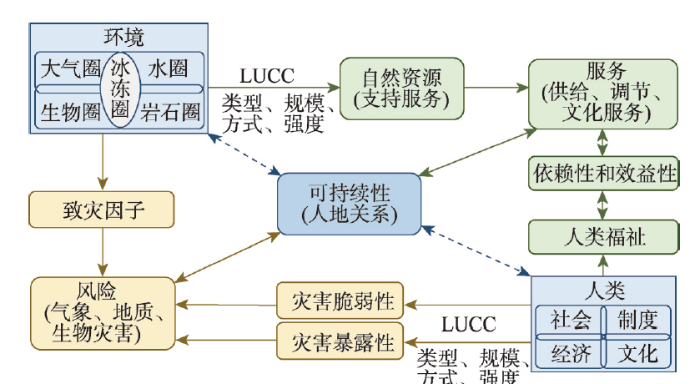
在理论上,LUCC研究需要与景观可持续科学紧密结合。景观可持续科学是聚焦于景观和区域尺度的,通过空间显示方法来研究景观格局、生态系统服务和人类福祉之间相互关系的科学,其最终目的是寻求能够促进生态系统服务和人类福祉长期维系和改善,以实现可持续发展的景观与区域空间格局[22, 94]。景观可持续科学以可持续科学研究框架为基础,以景观和区域为研究和实现可持续发展的关键尺度,为面向可持续性的LUCC研究提供了重要的理论基础和可操作的实践平台[117]。景观可持续科学的核心目标是协调人地关系,提高区域可持续性。其基本思路是以景观和区域尺度为基础,通过LUCC过程中土地利用类型、规模、方式和强度的调整,一方面改善自然资源和生态系统服务的供给能力以提高人类福祉,另一方面降低灾害暴露性和脆弱性以减少灾害风险(图8)。未来LUCC研究需要以维持和改善景观/区域可持续性为基本目标,以不同土地利用格局下生态系统服务、人类福祉和灾害风险间的相互关系为研究核心,以空间显示模型模拟和情景分析为主要手段,积极开展“生态系统—景观—区域”的多尺度综合集成研究[17, 94]。图8
 新窗口打开|下载原图ZIP|生成PPT
图8LUCC与景观可持续性
Fig. 8LUCC and landscape sustainability
在方法上,LUCC研究需要在大数据、云计算和人工智能为代表的新兴技术的支撑下,紧密结合地理设计。地理设计是以景观可持续科学为基础,在空间信息技术支撑下的,以区域可持续发展为目标的,强调地理学家、技术专家、设计师和利益相关者密切配合并将规划设计活动与实时的动态环境影响模拟紧密结合的一种规划设计理念和方法[117,118,119]。地理设计框架主要包括研究区域、决策者/利益相关者、地理设计团队、地理设计过程和地理设计方案等5个组成部分。其核心部分是地理设计过程,它主要回答6个问题,每个问题可以由对应的模型回答。比如,该研究区域是否运作正常?对该问题的回答可以通过评价模型来实现。在整个地理设计过程中,采用自上而下(顺序)明确项目的背景和范围(提出问题)、自下而上(逆序)明确项目的方法论(确定方法)和自上而下(顺序)进行整个项目直至给出结论(回答问题)的三迭代式工作模式(图9)。基于地理设计框架,LUCC研究可以有效地融合大数据、人工智能、云计算、区块链和虚拟现实等新兴技术,并通过表达模型、过程模型、评价模型、变化模型、影响模型和决策模型的有效集成以产出空间化、定量化和人性化的设计方案[120]。2010年由全球最大的GIS技术供应商——美国环境系统研究所(Environmental Systems Research Institute, ESRI)公司主办的首届地理设计峰会在美国南加州召开。之后,地理设计峰会每年举办一次。在每次峰会上,ESRI公司不仅会带来最新的GIS相关技术,还会展示来自世界各地的利用新兴技术开展的地理设计案例,为LUCC研究的技术革新带来了广阔的空间和展示的平台。因此,LUCC研究与地理设计的紧密结合不仅有益于LUCC研究技术与方法的提升,而且能够为LUCC研究提供实践应用框架与平台。
图9
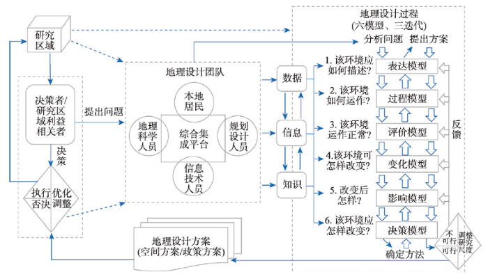 新窗口打开|下载原图ZIP|生成PPT
图9LUCC与地理设计
注:修改自文献[118]和[121]。
Fig. 9LUCC and geodesign
在实践上,LUCC研究需要积极面向国土空间规划主战场。国土空间规划是促进城乡融合与乡村振兴、建设美丽中国和落实联合国可持续发展目标的关键途径[122,123]。LUCC研究能够在土地利用空间格局的优化和管理方面与国土空间规划交叉融合,从而在理论上和方法上为国土空间规划提供支撑(图10)。在理论上,LUCC研究聚焦格局、服务和人类福祉三者之间的动态关系,通过格局和过程的多尺度耦合研究、生态系统服务制图与模拟以及服务与福祉复杂关系的探究,强调过程机理、区域集成和面向可持续发展研究的深入融合,可以为国土空间规划提供有效的理论支撑。在方法上,LUCC研究通过结合遥感技术、模型模拟和情景分析已形成了一套涵盖LUCC数据库、LUCC模型、LUCC与生态过程耦合模型、生态系统服务评估模型和人地耦合系统模型的完整技术路线,可以为国土空间规划提供基础数据和技术支撑。LUCC研究与国土空间规划的密切结合,必将推动LUCC研究的进一步提升。
图10
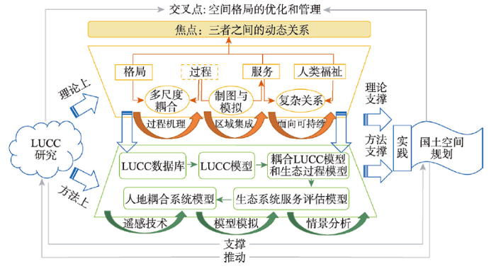 新窗口打开|下载原图ZIP|生成PPT
图10LUCC与国土空间规划
Fig. 10LUCC and spatial planning of national territory
6 结论
1990—2018年LUCC相关英文论文发文量和引文量呈指数增长趋势,正从过程和影响研究阶段迈向可持续性研究阶段。LUCC过程研究阶段的进展主要集中于LUCC数据库建立、LUCC驱动力分析与LUCC模型的发展上。LUCC影响研究阶段的主要进展表现在揭示了LUCC对自然生境和生物多样性、区域气候和空气质量、土壤理化性质以及水文过程的综合影响上。LUCC可持续研究阶段的突出进展主要表现在将LUCC过程嵌入人地系统模型、揭示LUCC对生态系统服务影响、重视LUCC对人类福祉影响以及面向可持续性的土地利用优化管理4个方面。在国际可持续科学快速发展,国内生态文明建设日益深入的背景下,LUCC研究正面临理论、方法和应用上的巨大挑战。在理论上,LUCC研究正面临如何在可持续科学研究框架下为联合国2030年可持续发展目标服务的问题。在方法上,如何整合大数据、云计算、人工智能和虚拟现实等新兴技术发展新的LUCC研究方法体系已成为当务之急。在应用上,如何整合可持续科学理论框架和新兴技术,深入贯彻落实国土空间规划,已成为LUCC研究面临的新挑战。因此,LUCC研究需要与景观可持续科学紧密结合,以不同土地利用格局下的生态系统服务、人类福祉和灾害风险之间相互关系为研究核心,开展综合集成研究。同时还需要紧密结合地理设计,促进新兴技术与LUCC研究的深度融合。此外,还需要积极面向国土空间规划的主战场,从理论、方法和实践上支撑国土空间规划,为建设美丽中国和落实联合国可持续发展目标服务。
致谢
感谢史培军教授和邬建国教授在成文过程中的启发和指点。参考文献 原文顺序
文献年度倒序
文中引用次数倒序
被引期刊影响因子
[本文引用: 1]
[本文引用: 1]
[本文引用: 1]
[本文引用: 3]
DOI:10.1038/461472aURL [本文引用: 1]
[本文引用: 1]
DOI:10.1016/S0959-3780(01)00007-3URL [本文引用: 1]
DOI:10.1126/science.1111772URL [本文引用: 3]
DOI:10.1016/j.ancene.2015.09.004URL [本文引用: 1]
DOI:10.1016/j.landusepol.2017.03.021URL [本文引用: 1]
DOI:10.1016/j.landusepol.2017.07.005URL [本文引用: 1]
DOI:10.11821/xb199606009 [本文引用: 2]

Land use and land cover change has aroused increasing attention of scientists worldwide since1990.Recognizing the importance of this change to other global environmental change and sustainable development issues,the International Geosphere-Biosphere ProgrammeIGBP)and the HumanDimensions of Global Environmental Change ProgrammeHDP)initiated a joint core projectLand Use and Land Cover Change(LUCC)and published a Science/Research Plan for the project.To promote the national LUCC projects,the paper presents a general review on the basic concepts,background,and Progress on the metnodologies of international LUCC researches.Land use/land cover is not a new research domain but is given new meanings and research contents in the context of global environmental change.Based on the definition of land cover given bythe IGBP/HDP and other international institutions,the author proposes a new translated term ofland cover in Chinese that matches the definition closely.This will avoid misunderstanding of thedomestic LUCC projects at early stages.Land cover changes refer to conversion and modification of vegetation,changes on biodiversity,soil quality,runoff,erosion,sedimentation and land productivity.International researches onLUCC involve:1)influence of LUCC on systematic global enviromental changes like biogeochemicalcircles and climatic variation,and cumulative global environmental changes like eforestation,biodiversity reduction and land degradation;2)response of LUCC to global environmental changes;3)LUCC and sustainable development including the sustainability of different land uses.The fundamental scientific issue of LUCC research is the dynamics of land use and coverchanges,which is extremely significant to the prediction of the global environmental change in thenext 50 to 100 years.The modedling of causes-use-cover system is challenge because of its inherentcomplexity.An integrated approach to the modeling is necessary that combines:1)large-scale onsite case study approach to land use dynamics;2)direct observation and measurement of land coverchange by using remote sensing images;and 3)regional and global modeling of economic processesrelated to LUCC.
[本文引用: 2]
[本文引用: 1]
[本文引用: 1]
[本文引用: 2]
[本文引用: 2]
[本文引用: 1]
[本文引用: 1]
DOI:10.11820/dlkxjz.2014.04.001 [本文引用: 4]
As a frontier and hot topic in ecology and geography, the study of ecosystem services has attracted the interest of many scholars and research institutions. By changing the structure and processes of ecosystems, landuse change affects the provisioning capability of ecosystems for products and services. Study of the relationships between ecosystem processes and services, the relationships among multiple ecosystem services, and the integration and optimization of these services at the regional scale in the context of land-use change urgently needs to be enhanced. The results of such research will be critically important for informing and supporting activities of ecosystem management. This paper introduces the concepts and methods of the study of land- use change and ecosystem services and discusses the shortcomings of existing studies and future prospects of land-use change and ecosystem services research.
[本文引用: 4]
[本文引用: 1]
[本文引用: 1]
[本文引用: 2]
[本文引用: 2]
[本文引用: 2]
PMID:18093934 [本文引用: 1]
Land change science has emerged as a fundamental component of global environmental change and sustainability research. This interdisciplinary field seeks to understand the dynamics of land cover and land use as a coupled human-environment system to address theory, concepts, models, and applications relevant to environmental and societal problems, including the intersection of the two. The major components and advances in land change are addressed: observation and monitoring; understanding the coupled system-causes, impacts, and consequences; modeling; and synthesis issues. The six articles of the special feature are introduced and situated within these components of study.
PMID:24851141 [本文引用: 1]
This issue of provides an overview of recent advances in Land System Science while at the same time setting the research agenda for the Land System Science community. Land System Science is not just representing land system changes as either a driver or a consequence of global environmental change. Land systems also offer solutions to global change through adaptation and mitigation and can play a key role in achieving a sustainable future earth. The special issue assembles 14 articles that entail different perspectives on land systems and their dynamics, synthesizing current knowledge, highlighting currently under-researched topics, exploring scientific frontiers and suggesting ways ahead, integrating a plethora of scientific disciplines.
[本文引用: 2]
DOI:10.1007/s10980-013-9894-9URL [本文引用: 3]
DOI:10.1080/014311600210209URL [本文引用: 1]
DOI:10.1080/014311600210191URL [本文引用: 1]
[本文引用: 1]
DOI:10.1016/S0034-4257(02)00078-0URL [本文引用: 1]
[本文引用: 1]
[本文引用: 1]
[本文引用: 2]
[本文引用: 2]
[本文引用: 1]
[本文引用: 1]
DOI:10.1016/S0304-3800(01)00359-3URL [本文引用: 1]
DOI:10.1111/1467-8306.9302004URL [本文引用: 1]
DOI:10.1007/s10980-009-9380-6URL [本文引用: 1]
[本文引用: 1]
[本文引用: 1]
PMID:12148073 [本文引用: 1]
Land-use change models are important tools for integrated environmental management. Through scenario analysis they can help to identify near-future critical locations in the face of environmental change. A dynamic, spatially explicit, land-use change model is presented for the regional scale: CLUE-S. The model is specifically developed for the analysis of land use in small regions (e.g., a watershed or province) at a fine spatial resolution. The model structure is based on systems theory to allow the integrated analysis of land-use change in relation to socio-economic and biophysical driving factors. The model explicitly addresses the hierarchical organization of land use systems, spatial connectivity between locations and stability. Stability is incorporated by a set of variables that define the relative elasticity of the actual land-use type to conversion. The user can specify these settings based on expert knowledge or survey data. Two applications of the model in the Philippines and Malaysia are used to illustrate the functioning of the model and its validation.
[本文引用: 1]
[本文引用: 1]
[本文引用: 1]
DOI:10.1111/geb.2007.16.issue-3URL [本文引用: 1]
[本文引用: 1]
DOI:10.1038/nature11148URL [本文引用: 1]
DOI:10.1126/science.1165115PMID:18845749 [本文引用: 1]
Knowledge of mammalian diversity is still surprisingly disparate, both regionally and taxonomically. Here, we present a comprehensive assessment of the conservation status and distribution of the world's mammals. Data, compiled by 1700+ experts, cover all 5487 species, including marine mammals. Global macroecological patterns are very different for land and marine species but suggest common mechanisms driving diversity and endemism across systems. Compared with land species, threat levels are higher among marine mammals, driven by different processes (accidental mortality and pollution, rather than habitat loss), and are spatially distinct (peaking in northern oceans, rather than in Southeast Asia). Marine mammals are also disproportionately poorly known. These data are made freely available to support further scientific developments and conservation action.
DOI:10.1016/j.biocon.2012.07.015URL [本文引用: 1]
DOI:10.1038/s41558-019-0406-z [本文引用: 1]
Habitat transformations caused by human land-use change are considered major drivers of ongoing biodiversity loss(1-3), and their impact on biodiversity is expected to increase further this century(4-6). Here, we used global decadal land-use projections to year 2070 for a range of shared socioeconomic pathways, which are linked to particular representative concentration pathways, to evaluate potential losses in range-wide suitable habitat and extinction risks for approximately 19,400 species of amphibians, birds and mammals. Substantial declines in suitable habitat are identified for species worldwide, with approximately 1,700 species expected to become imperilled due to land-use change alone. National stewardship for species highlights certain South American, Southeast Asian and African countries that are in particular need of proactive conservation planning. These geographically explicit projections and model workflows embedded in the Map of Life infrastructure are provided to facilitate the scrutiny, improvements and future updates needed for an ongoing and readily updated assessment of changing biodiversity. These forward-looking assessments and informatics tools are intended to support national conservation action and policies for addressing climate change and land-use change impacts on biodiversity.
PMID:10710299 [本文引用: 1]
Scenarios of changes in biodiversity for the year 2100 can now be developed based on scenarios of changes in atmospheric carbon dioxide, climate, vegetation, and land use and the known sensitivity of biodiversity to these changes. This study identified a ranking of the importance of drivers of change, a ranking of the biomes with respect to expected changes, and the major sources of uncertainties. For terrestrial ecosystems, land-use change probably will have the largest effect, followed by climate change, nitrogen deposition, biotic exchange, and elevated carbon dioxide concentration. For freshwater ecosystems, biotic exchange is much more important. Mediterranean climate and grassland ecosystems likely will experience the greatest proportional change in biodiversity because of the substantial influence of all drivers of biodiversity change. Northern temperate ecosystems are estimated to experience the least biodiversity change because major land-use change has already occurred. Plausible changes in biodiversity in other biomes depend on interactions among the causes of biodiversity change. These interactions represent one of the largest uncertainties in projections of future biodiversity change.
DOI:10.1007/s00382-004-0430-0URL [本文引用: 1]
DOI:10.1002/joc.2157URL [本文引用: 1]
DOI:10.1002/joc.v30:13URL [本文引用: 1]
DOI:10.1016/j.atmosenv.2011.07.028URL [本文引用: 1]
[本文引用: 1]
DOI:10.1051/agro/2010007URL [本文引用: 1]
DOI:10.1016/j.geoderma.2009.03.011URL [本文引用: 1]
DOI:10.1016/j.cosust.2012.06.006URL [本文引用: 1]
DOI:10.1007/s11269-010-9676-yURL [本文引用: 1]
[本文引用: 1]
[本文引用: 1]
[本文引用: 1]
[本文引用: 1]
[本文引用: 1]
DOI:10.1111/gcb.2007.13.issue-11URL [本文引用: 1]
DOI:10.1038/449409aURL [本文引用: 1]
DOI:10.1038/nclimate1690URL [本文引用: 1]
[本文引用: 1]
DOI:10.1146/energy.2003.28.issue-1URL [本文引用: 1]
[本文引用: 1]
DOI:10.1038/470307aURL [本文引用: 1]
PMID:17069873 [本文引用: 1]
Assessment of seasonal changes in surface water quality is an important aspect for evaluating temporal variations of river pollution due to natural or anthropogenic inputs of point and non-point sources. In this study, surface water quality data for 16 physical and chemical parameters collected from 22 monitoring stations in a river during the years from 1998 to 2001 were analyzed. The principal component analysis technique was employed to evaluate the seasonal correlations of water quality parameters, while the principal factor analysis technique was used to extract the parameters that are most important in assessing seasonal variations of river water quality. Analysis shows that a parameter that is most important in contributing to water quality variation for one season may not be important for another season except for DOC and electrical conductance, which were always the most important parameters in contributing to water quality variations for all four seasons.
DOI:10.1016/j.envpol.2009.10.047PMID:19931958 [本文引用: 1]
Estimates of non-point source (NPS) contribution to total water pollution in China range up to 81% for nitrogen and to 93% for phosphorus. We believe these values are too high, reflecting (a) misuse of estimation techniques that were developed in America under very different conditions and (b) lack of specificity on what is included as NPS. We compare primary methods used for NPS estimation in China with their use in America. Two observations are especially notable: empirical research is limited and does not provide an adequate basis for calibrating models nor for deriving export coefficients; the Chinese agricultural situation is so different than that of the United States that empirical data produced in America, as a basis for applying estimation techniques to rural NPS in China, often do not apply. We propose a set of national research and policy initiatives for future NPS research in China.Copyright 2009 Elsevier Ltd. All rights reserved.
URL [本文引用: 1]
DOI:10.1007/s10584-012-0635-xURL [本文引用: 2]
DOI:10.1175/JHM-D-13-0182.1URL [本文引用: 1]
DOI:10.1038/nclimate3310URL [本文引用: 1]
DOI:10.1007/s00376-015-5050-6URL [本文引用: 1]
DOI:10.1007/s00382-007-0228-yURL [本文引用: 1]
DOI:10.1007/s10584-006-9108-4URL [本文引用: 1]
DOI:10.5194/gmd-8-2203-2015URL [本文引用: 2]
DOI:10.1016/j.gloplacha.2019.06.003URL [本文引用: 1]
[本文引用: 2]
URL [本文引用: 1]
DOI:10.1016/j.gfs.2014.08.004URL [本文引用: 1]
DOI:10.1016/j.agsy.2015.11.008URL [本文引用: 2]
[本文引用: 1]
DOI:10.1021/es4051988URL [本文引用: 1]
DOI:10.1016/j.ecolecon.2013.10.005URL [本文引用: 1]
URL [本文引用: 1]
URL [本文引用: 1]
URL [本文引用: 1]
DOI:10.5194/esd-5-309-2014URL [本文引用: 1]
DOI:10.1016/j.ecoser.2018.02.011URL [本文引用: 1]
DOI:10.1016/j.cub.2019.08.026 [本文引用: 1]
If current trends continue, the tropical forests of the Anthropocene will be much smaller, simpler, steeper and emptier than they are today. They will be more diminished in size and heavily fragmented (especially in lowland wet forests), have reduced structural and species complexity, be increasingly restricted to steeper, less accessible areas, and be missing many heavily hunted species. These changes, in turn, will greatly reduce the quality and quantity of ecosystem services that tropical forests can provide. Driving these changes will be continued clearance for farming and monoculture forest plantations, unsustainable selective logging, over-hunting, and, increasingly, climate change. Concerted action by local and indigenous communities, environmental groups, governments, and corporations can reverse these trends and, if successful, provide future generations with a tropical forest estate that includes a network of primary forest reserves robustly defended from threats, recovering logged and secondary forests, and resilient community forests managed for the needs of local people. Realizing this better future for tropical forests and people will require formalisation of land tenure for local and indigenous communities, better-enforced environmental laws, the widescale roll-out of payments for ecosystem service schemes, and sustainable intensification of under-yielding farmland, as well as global-scale societal changes, including reduced consumerism, meat consumption, fossil fuel reliance, and population growth. But the time to act is now, while the opportunity remains to protect a semblance of intact, hyperdiverse tropical forests.
[本文引用: 1]
[本文引用: 1]
DOI:10.1016/j.scitotenv.2015.01.007URL [本文引用: 1]
DOI:10.1016/j.ecolecon.2014.04.001URL [本文引用: 1]
DOI:10.1016/j.ecoser.2017.08.013URL [本文引用: 2]
DOI:10.1007/s12665-015-5103-2URL [本文引用: 2]
PMID:24765835 [本文引用: 5]
Sustainability is the theme of our time and also the grandest challenge to humanity. Since the 1970s, the term, sustainable development, has frequently appeared in the scientific literature, governmental documents, media promotions for public goods, and commercial advertisements. However, the science that provides the theoretical foundation and practical guidance for sustainable development--sustainability science--only began to emerge in the beginning of the 21st century. Nevertheless, the field has rapidly developed in depth and expanded in scope during the past decade, with its core concepts and research methods coalescing. China, as the most populous country in the world and home to the philosophical root of sustainability science-the unity of man and nature, is obligated to take upon the challenge of our time, to facilitate global sustainability while pursuing the Chinese Dream, and to play a leading role in the development of sustainability science. Toward this grandiose goal, this paper presents the first Chinese introduction to sustainability science, which discusses its basic concepts, research questions, and future directions. Sustainability science is the study of the dynamic relationship between humans and the environment, particularly focusing on the vulnerability, robustness, resilience, and stability of the coupled human-environment system. It is a transdisciplinary science that integrates natural sciences with humanities and social sciences. It hinges on the environment-economy-society nexus, and merges basic and applied research. The key components of sustainability often change with time, place, and culture, and thus sustainability science needs to emphasize multi-scale studies in space and time, with emphasis on landscapes and regions over a horizon of 50 to 100 years. It needs to focus on the relationship between ecosystem services and human well-being, as influenced by biodiversity and ecosystem processes as well as climate change, land use change, and other socioeconomic drivers. Landscape sustainability is at the core of sustainability science, and is expected to be a hot research topic in the next few decades.
PMID:24765835 [本文引用: 5]
DOI:10.1016/j.ecolind.2018.05.052URL [本文引用: 1]
DOI:10.1016/j.landusepol.2018.01.003URL [本文引用: 1]
DOI:10.1016/j.ecolind.2018.09.030 [本文引用: 1]
Planning urban landscape is essential for maintaining key ecosystem services (ESs) in rapidly urbanizing areas and has become one of the key questions in urban ecology and landscape ecology. In this study, we simulated the urban landscape dynamics in the Beijing-Tianjin-Hebei (BTH) urban agglomeration in China during the period of 2013-2040 under different ES conservation scenarios by combining ES conservation priority areas, the Land Use Scenario Dynamics-urban (LUSD-urban) model, and scenario analysis to explore approaches to planning urban landscapes with the goal of maintaining and conserving key ESs. We found that the key ESs could be effectively maintained with urban landscape planning in the BTH urban agglomeration. The loss of food production (FP) under the provisioning service conservation scenario will be 80.88% lower than that under the business-as-usual (BAU) scenario, and the loss of regulating services under the regulating service conservation scenario will be 1.42-10.34% lower than that under the BAU scenario. The loss of recreation service (RS) under the cultural service conservation scenario will be 41.52% lower than that under the BAU scenario. The integrative conservation scenario will be the best scenario to maintain ESs because the losses of FP, carbon storage (CS), water retention (WR), and air purification (AP) will be 29.31-78.49% lower than those under the BAU scenario. Protecting cropland and woodland will be an effective strategy in planning urban landscape to maintain key ESs. When cropland and woodland were protected, ES losses under the integrative conservation scenario will be 85.67-98.58% lower than those under the BAU scenario. Promoting the coordinated development of cities of different sizes will be another effective strategy in planning urban landscape. Under the best scenario of maintaining key ESs, i.e., the integrative conservation scenario, ESs in megacities and large cities can be protected, while ES losses will mainly occur in medium-sized cities. The ES losses in medium-sized cities will account for 60% of the total losses across the entire region. To ensure sustainable development in the BTH urban agglomeration, we suggest that effective policies and regulations be implemented to protect cropland and woodland areas and to promote the coordinated development of cities of different sizes to maintain key ESs.
[本文引用: 1]
[本文引用: 1]
[本文引用: 1]
[本文引用: 1]
[本文引用: 1]
[本文引用: 1]
[本文引用: 1]
DOI:10.5194/esd-9-895-2018URL [本文引用: 1]
[本文引用: 1]
PMID:11330321 [本文引用: 1]
[本文引用: 1]
DOI:10.1038/nature21694URL [本文引用: 1]
[本文引用: 1]
[本文引用: 1]
[本文引用: 1]
DOI:10.1038/s41467-019-13993-7URL [本文引用: 1]
[本文引用: 1]
[本文引用: 1]
[本文引用: 1]
[本文引用: 1]
[本文引用: 1]
[本文引用: 1]
[本文引用: 1]
DOI:10.11821/dlxb201912004 [本文引用: 1]
Beautiful China is the new goal of ecological civilization construction in the new era of socialism, which can meet the real needs of the people for a better life. National land space planning is a major deployment of the state to coordinate various types of space planning. Beautiful China is the new leading goal of the country's second centenary development. Its connotation is not only "ecological beauty", but also the comprehensive beauty of "economy-politics-culture-society-ecology". The construction of beautiful China needs a differentiated evaluation index system based on the local conditions. Beautiful China is closely related to the land spatial planning. The former provides an important direction for the latter, while the latter provides an important approach and space guarantee for the construction of the former. The establishment of land spatial planning needs to strengthen the further discussion of the regional system of human-environment interaction, point-axis system, the main functional area planning, sustainable development and resource environmental carrying capacity, new urbanization and rural regional multi-body system. This paper puts forward the thinking framework of land spatial planning from the perspective of geography, including scientifically analyzing the natural geographical conditions, economic and social development basis, and the interrelationship between land and space, planing the goal, vision and path of land and space, encouraging the public to participate in and carry out dynamic evaluation, and building an intelligent system platform for land and spatial planning with the goal of beautiful China, which provide ideas for the compilation and implementation of land spatial planning.
[本文引用: 1]
DOI:10.11821/dlyj020190865 [本文引用: 1]
The spatial organization law of territorial function-structure is the basic theoretical problem of human-earth system coupling research, as well as the basic theory of carrying out territorial spatial planning and shaping sustainable geographical pattern. Starting from the discussion of geography on the repetition, prediction, regulation and optimization of geographical processes, this paper explains that the spatial governance system is an important way for modern geography to regulate and optimize the sustainable geographical processes and patterns. The spatial and temporal evolution characteristics of the spatial structure of territorial function composed of ecological-life-production (also known as three living spaces) are adopted to express the spatial order law of territorial function - structure, and explain some spatial organization goals, e.g., the coordination between territorial function and natural geographical environment, the minimization of various functions and conflicts between different units in the same region, the effective transmission of territorial functions in different spatial scales, and the maximization of comprehensive benefits in a long time scale. On the one hand, from the perspective of sustainability, the concept of four attributes of natural elements -- resources, environment, ecology and disasters -- is proposed. Through the integration of the four attributes, the natural carrying capacity is constructed, and the function of the original value, remaining value and potential value of carrying capacity in spatial planning is analyzed, so as to form the basic method of analyzing spatial organization from bottom to top. On the other hand, starting from new spatial equilibrium, the basic method of top-down spatial organization analysis is formed based on the territorial functional suitability of carrying capacity, integrated position and spatial structure parameters. Furthermore, the basic and strategic values of the major function zoning formed by the two methods for spatial organization and planning are discussed, and a new idea of separation and interrelation of the zoning, strategy, system with planning of utilization is proposed. With the implementation of the strategy of major function zoning as the main line, the spatial scale-down conduction of major functions as the core scientific problem, and the key constraint parameters as the control indicators of spatial structure, this paper discusses the database and territorial function pedigree, functional and scale-dependent carrying capacity evaluation method and model, and the construction framework of "Three Zones and Three Lines" (Three Zones represent ecological space, agricultural space, and urban space; Three Lines represent ecological conservation redline, permanent capital farmland, and urban development boundary), and demonstrates the way to implement the strategy of major function zoning in spatial planning. Finally, the paper puts forward some suggestions that geography should strengthen the construction of scientific and technological support system, e.g., the basic theory, method and technology of large and medium spatial scale (regional) territorial spatial planning.
[本文引用: 1]
DOI:10.31497/zrzyxb.20191004URL [本文引用: 1]
[本文引用: 1]
DOI:10.1080/1747423X.2019.1602677URL [本文引用: 2]
[本文引用: 2]
[本文引用: 1]
[本文引用: 1]
DOI:10.3390/su11030833URL [本文引用: 1]
[本文引用: 1]
[本文引用: 1]
DOI:10.11821/dlxb201804004 [本文引用: 1]
Cities and villages are components of a specific organism. Only the sustainable development of two parts can support the prosperous development as a whole. According to the theory of man-earth areal system, urban-rural integrated system and rural regional system are the theoretical bases for entirely recognizing and understanding urban-rural relationship. To handle the increasingly severe problems of "rural disease" in rapid urbanization, accelerating rural revitalization in an all-round way is not only a major strategic plan for promoting the urban-rural integration and rural sustainable development, but also a necessary requirement for solving the issues related to agriculture, rural areas, and rural people in the new era and securing a decisive victory in building a moderately prosperous society in all respects. This study explores the basic theories of urban-rural integration and rural revitalization and analyzes the main problems and causes of rural development in the new era, proposing problem-oriented scientific approaches and frontier research fields of urban-rural integration and rural revitalization in China. Results show that the objects of urban-rural integration and rural revitalization is a regional multi-body system, which mainly includes urban-rural integration, rural complex, village-town organism, and housing-industry symbiosis. Rural revitalization focuses on promoting the reconstruction of urban-rural integration system and constructs a multi-level goal system including urban-rural infrastructure networks, zones of rural development, fields of village-town space and poles of rural revitalization. Currently, the rural development is facing the five problems: high-speed non-agricultural transformation of agriculture production factors, over-fast aging and weakening of rural subjects, increasingly hollowing and abandoning of rural construction land, severe fouling of rural soil and water environment and deep pauperization of rural poverty-stricken areas. The countryside is an important basis for the socioeconomic development in China, and the strategies of urban-rural integration and rural revitalization are complementary. The rural revitalization focuses on establishing the institutional mechanism for integrated urban-rural development and constructs the comprehensive development system of rural regional system, which includes transformation, reconstruction and innovation in accordance with the requirements of thriving businesses, pleasant living environments, social etiquette and civility, effective governance, and prosperity. Geographical research on rural revitalization should focus on the complexity and dynamics of rural regional system and explore new schemes, models and scientific approaches for the construction of villages and towns, which are guided by radical cure of "rural disease", implement the strategy of rural revitalization polarization, construct the evaluation index system and planning system of rural revitalization, thus providing advanced theoretical references for realizing the revitalization of China's rural areas in the new era.
[本文引用: 1]
DOI:10.11821/dlxb201904001 [本文引用: 1]
Beautiful China construction (BCC) is of fundamental importance for the sustainable development of the Chinese nation and a Chinese practice of the 2030 UN sustainable development agenda. The Chinese government has made strategic arrangements for the BCC with a five-pronged approach. President Xi Jinping proposed the schedule and roadmap for the BCC at the National Ecological Environmental Protection Conference. But at present, the theoretical basis, evaluation index system, evaluation criteria and construction effect of the BCC are not clear. This paper puts forward the basic connotation of the BCC from a broad and narrow perspective, regards the theory of man-earth harmony and Five-dimensional integration as the core theoretical basis of the BCC, and further constructs the evaluation index system of the BCC, which includes five dimensions: ecological environment, green development, social harmony, institutional improvement and cultural heritage, and uses the United Nations human development index (HDI) evaluation method to scientifically evaluate the construction effect of 341 prefecture-level cities (states) in China in 2016. The results show that the average value of the BCC Index (Zhongke Beauty Index) is 0.28, which is generally at a low level. The average of the sub-indexes of the ecological environment beauty index, the green development beauty index, the social harmony beauty index, the system perfect beauty index and the cultural heritage beauty index are respectively 0.6, 0.22, 0.29, 0.22, and 0.07. The sub-index values are all low, and the regional development is quite different, which indicates that the construction process of Beautiful China is generally slow and unbalanced. In order to implement the schedule and roadmap for the BCC with high quality and high standards, it is recommended that we construct and publish a general evaluation system for the BCC process, carry out dynamic monitoring and phased comprehensive evaluation of the BCC process, compile and publish the evaluation standards for BCC technology, do a good job in the comprehensive zoning of Beautiful China, carry out pilot projects for the construction of Beautiful China's model areas according to local conditions, and incorporate the achievements of Beautiful China into the assessment indicators of all levels of government.
[本文引用: 1]
