 ,1,2,3, 李寻欢1,2,3
Basic theories and frontiers of poverty geography
ZHOU Yang,1,2,3, LI Xunhuan1,2,3收稿日期:2020-08-20修回日期:2021-06-20
| 基金资助: |
Received:2020-08-20Revised:2021-06-20
| Fund supported: |
作者简介 About authors
周扬(1984-), 男, 贵州普安人, 副研究员, 硕士生导师, 主要从事贫困地理与乡村振兴研究。E-mail:

摘要
关键词:
Abstract
Keywords:
PDF (2332KB)元数据多维度评价相关文章导出EndNote|Ris|Bibtex收藏本文
本文引用格式
周扬, 李寻欢. 贫困地理学的基础理论与学科前沿. 地理学报, 2021, 76(10): 2407-2424 doi:10.11821/dlxb202110006
ZHOU Yang, LI Xunhuan.
1 引言
自人类社会诞生以来,受资源禀赋、区位条件、自然灾害和战争等因素影响,贫困问题始终存在,始终是全人类发展进程中面临的一项重大难题和现实问题。从古至今、从东到西,人类对贫困的观察和思考并未停止。从某种意义上来说,一部人类文明发展的历史,就是与贫困作斗争的历史。早在公元8世纪初的唐朝,诗人白居易在《观刈麦》中写到:“复有贫妇人,抱子在其旁,右手秉遗穗,左臂悬敝筐”,生动形象地描绘出了农村贫困妇女带着孩子在田间劳作的现实景象。1979年美国经济学家Theodore Schultz在诺贝尔经济学奖的获奖演说中指出:“世界上大多数人是穷人,理解了穷人的经济学,也就理解了经济学中的绝大数理论”[1]。按照世界银行每人每天消费支出低于1.9美元(2011年购买力平价)的标准估计,1990—2015年全球极端贫困人口从18.95亿减少到7.36亿,极端贫困发生率从35.9%下降到10%[2]。中国曾经是世界上贫困问题最为突出的少数几个国家之一,自2013年精准扶贫战略提出到2019年,中国农村贫困人口由9899万人减少至551万人,农村贫困发生率从10.2%下降至0.6%[3],为全球减贫事业作出了巨大贡献,创造了世界减贫史的一大奇迹。绝对贫困能够消除,但相对贫困仍将长期存在[4]。减贫与发展将会是学术界生生不息、永不过时的研究主题和热点话题。贫困研究的科学史已逾百年,涉及经济学、社会学、地理学等诸多学科。学术界对贫困概念和内涵的认知随着研究的深入不断深化、细化,从单一维度的收入/消费贫困发展到了多维贫困(包括教育、医疗、住房、收入、营养、权利、能力等)[4,5]。19世纪80年代,英国社会学家Charles Booth[6]在对伦敦工人阶级的实证调查中,基于阶层和社会地位定义了相对贫困,运用定性与定量相结合的方法按最贫困到最富裕的顺序将工人分为8个层次,并绘制了伦敦的贫困地图。但Booth对贫困的定义是一种相对模糊的、描述性的定义[7]。20世纪初,受Booth的启发,Rowntree[8]对英国英格兰东北部的约克郡贫困人口的生活条件进行了综合调查,并在《贫困:城镇生活研究》一书中基于人类食物摄入的最低营养需求,首次明确界定了贫困与贫困线的概念。Rowntree的开创性工作引领了近100年贫困理论研究与政府减贫实践,是经济学中收入贫困理论的核心内容[9]。20世纪70年代以来,Sen提出的能力贫困与多维贫困理论[10,11],以及社会****主张的社会排斥与权利贫困理论[12,13,14]极大地丰富了贫困的内涵。2019年诺贝尔经济学奖颁给了Abhijit V. Banerjee等,以表彰他们通过实验性方案减轻全球贫困的突出贡献。Banerjee等[14]在《贫穷的本质:为什么我们摆脱不了贫穷》一书中指出稀缺(Scarcity)和带宽(Bandwith)是导致贫穷的两个主要原因。然而,这些理论均停留在个体贫困层面,缺少对区域贫困的关注和解释。尽管部分****提出PPE(Poverty-Population-Environment)怪圈理论[15]、空间贫困理论[16,17]、贫困恶性循环理论和贫困“孤岛效应”理论[18],但由于原创性理论不足、学科体系不健全、研究关注度不够,贫困地理基础研究滞后于反贫困实践。“理论贫困”成为制约新时期贫困地理学创新发展的最大短板和瓶颈。
国内地理学界对贫困问题的研究起步较晚。20世界80年代末,由中国科学院、原国家计划委员会地理研究所主持完成国家扶贫规划任务,研制的“中国的贫困地区类型及开发”方案直接支撑了国家“八七”扶贫攻坚计划[19]。20世纪90年代以来,贫困地理研究在国家扶贫开发纲要的编制和14个集中连片特殊困难地区的划定中发挥了重要作用。2015年以中国科学院地理科学与资源研究所为牵头单位开展国家精准扶贫工作成效第三方评估以来,一大批地理****和青年学生走村入户、深入基层,积累了大量贫困人口和贫困地区的一手资料和减贫经验,并涌现了众多学术研究成果,包括农村贫困化的孤岛效应[18]、个体贫困的累积放大效应[4]、扶贫成效边际递减效应[20]和贫困地域系统[21]等原创性理论研究成果,以及区域多维贫困测度[4]、区域贫困的地理学分析[22]等理论分析框架,有力地支撑了新时期国家脱贫攻坚成效考核和精准脱贫决策。2020年11月17日“一带一路”减贫与发展联盟成立,旨在开展“一带一路”地区减贫与发展的国际合作研究与技术研发,推进中国与“一带一路”沿线国家的扶贫开发经验和模式共享,为推动中国贫困研究的国际化提供了重要平台。
目前,中国已全面打赢了脱贫攻坚战,实现了全面建成小康社会的第一个百年目标。尽管如此,现行标准下绝对贫困的消除不代表贫困的终结,绝对贫困和相对贫困始终会长存,区域贫困和个体贫困会随人类社会共存。从某种意义上来说,贫困是特定地区特定时期内人地关系失衡的一种外在表现[4-5, 23]。人地关系是地理学的研究核心,从地理学人地关系视角审视贫困发生机理和贫困与地理环境的关系对于深化贫困基础理论认知具有重要的科学价值[21]。贫困是人类社会永恒的主题,地理学贫困问题研究不应随着当前国家脱贫攻坚战取得了阶段性胜利而被弱化,反而应该被加强,亟需要进一步深化贫困地理学研究,继续发挥地理学服务于国家减贫与发展战略的学科特长和优势。
当前,我们亟需且有条件建立贫困地理学。一方面,发展贫困地理学是破解全球贫困问题现实难题和实现可持续发展目标的需要。在中国减贫方案走向国际的实践中,亟需贫困地理学在基础理论、区域瞄准、科学减贫等方面的理论支撑和技术支持。另一方面,2013年以来国内大量地理****参与到贫困地理理论研究与第三方评估扶贫实践中,积累了丰富的贫困资料、减贫经验和学术成果,涌现了一批心系三农、了解基层、致力于研究解决贫困问题的青年学生和学术后备人才。同时,人工智能、大数据、云计算、物联网、区块链、无人机等现代科学技术为贫困问题研究朝纵深方向发展提供了强有力的工具,更有利于揭示贫困发生的本质。因此,本文在明晰贫困相关概念的基础上,系统探究贫困地理学作为一门分支学科的基础理论、学科性质、研究对象与研究内容,提出未来贫困地理学研究中的关键前沿领域,深化贫困地理学研究,以期为区域可持续减贫与发展提供理论依据和研究指引。
2 贫困基本概念辨析
2.1 贫困
给“贫困”这一术语下一个准确的定义是件极其困难的事情。19世纪末20世纪初,以Rowntree[8]为代表的经济****认为,贫困是指家庭收入低、难以满足人类生存对食物和营养等基本商品和服务的需求。20世纪70—80年代,Sen[10, 24]提出了能力贫困理论,认为贫困是个体发展能力的不足。2001年联合国经济、社会和文化权利委员会[25]将贫困定义为“个体的资源、能力、机会、安全和权利受到持续或长期性剥夺,难以享受基本生活福利和其他公民、文化、经济、政治和社会权利”。从贫困概念的演化历程来看,贫困具有极其丰富的内涵。首先,“贫困”从词意上看既有“贫”也有“困”之意。前者描述数量,表示缺少、不足或匮乏之意;后者刻画状态,可理解为困境、窘境。“贫困”可以简单地理解为一种缺少或不足的状态。其次,贫困是一个以人为主体的概念,反贫困的出发点、聚焦点和回归点均是“人”[26]。因此,贫困描述了作为行为主体的“人”在某一方面缺少或不足的状态。再次,从福利主义的视角看,人类的生存和发展有着不同层次、不同类型的福利需求,例如对基本营养和社会包容性的需求。贫困则刻画了人们在福利方面缺失或剥夺的状态,这种状态既有可能来自于主观上幸福感、满足感以及安全感的缺失,也有可能来自于就业市场与政策、区位条件和发展环境等客观因素的限制。最后,贫困自身是一个“相对”的概念。“相对”可以理解为:任意一方面的缺少或不足总是与一个标准相比较,否则难以表达和度量。综上,我们可以将“贫困”理解为:与一定标准相比,人们所享受的各种福利处于劣势、缺少或不足的状态。贫困具有多维性、区域性、动态性和复杂性特征[4]。贫困的多维性主要表现在福利的多样性。贫困表征福利的缺失与剥夺,包括经济、社会和环境3个维度[23],分别对应经济福利、社会福利和环境福利的剥夺。经济福利剥夺主要包括收入低下、消费不足、经济增长缓慢等,经济发展水平低下是经济贫困的具体表现。社会福利剥夺则体现在教育/医疗不足、机会不平等、社会排斥等方面,导致社会贫困。环境福利的剥夺主要通过自然地理环境的劣势来体现,包括资源禀赋不足、区位条件差、生态环境脆弱、生态系统服务供给不足或生态保护、环境污染严重等,容易出现生态贫困。贫困的区域性是指贫困人口的空间分布具有显著集聚性特征。已有研究证实,在不同地域类型、不同空间尺度,贫困人口主要聚集在偏远山区和少数民族地区[18, 23, 27-28]。贫困的动态性是指贫困人口及其贫困程度随减贫投入的增加和扶贫力度的加大在空间上发生动态变化,贫困的动态性还与贫困标准或贫困线的变化密切相关。贫困的多维性和动态性决定了其复杂性,贫困问题是一个社会经济系统和生态环境系统耦合失调的复杂的系统性问题。
2.2 绝对贫困与相对贫困
从贫困测量的标准和方法来看,贫困包括绝对贫困和相对贫困。绝对贫困又称“极端贫困”,表征人们难以满足生理或物质上的最低需要,在测量标准上更强调“极小值”。相对贫困指个人或家庭的收入及其所拥有的资源能够满足其基本生活需要,但难以达到社会平均水平[29],在测量标准上更强调“平均值”。绝对贫困与相对贫困的差别体现在5个方面:① 绝对贫困测量方法简单、方便,而相对贫困标准不一,难以测量。绝对贫困测量是通过人类生存发展的基本需求来划分贫困线。中国脱贫攻坚期间家庭人均收入2300元(2010年购买力平价)以及现阶段世界银行每人每天1.9美元的贫困标准,都是绝对贫困线。相对贫困测量是从收入分配的视角,以他人为参照,与平均水平相比存在的差距和不足。相对贫困测量起源于20世纪60年代,在20世纪末的欧洲逐渐流行,常以平均值或中位数的固定比例(如40%、50%、60%)作为相对贫困线[30]。② 绝对贫困反映了一个家庭或地区在收入或经济方面的总量和水平,而相对贫困更多用于表征收入分配与区域经济发展中的不平等程度。③ 绝对贫困更多用于中低收入国家或欠发达国家,刻画的贫困程度更高;相对贫困更多用于发达国家,刻画的贫困程度较低。④ 绝对贫困使用相对独立的、唯一确定的标准,很少随着时间变化;相对贫困则随着地方收入水平和生活条件而变化[31]。⑤ 在减贫成效上,绝对贫困在政府和市场的共同作用下可以解决甚至消除,而相对贫困则主要依靠政府在二次分配中通过宏观调控得到减缓、难以根除。当然,绝对贫困与相对贫困并不是完全对立的概念,两者也存在一定程度的联系。① 本质上来说,贫困是一个相对的概念。相对贫困和绝对贫困本身就是“相对”的,并不能完全区分,是相互包含的[9]。绝对贫困的标准不是一个唯一值,是“相对”的。即使从人类生存发展的最低营养需求来测算,由于食品价格波动,绝对贫困线也会随着社会经济阶段的差异有所变化。相对贫困自身就包含着绝对贫困,这是因为其测量标准更高,最终识别出的相对贫困人口和地区涵盖了绝对贫困人口和地区。② 绝对贫困与相对贫困并存。当物质资源匮乏时必然会出现绝对贫困;而物质资源充裕时,由于难以实现绝对平均,相对贫困也不会消失[31]。绝对贫困与相对贫困的共存共生意味着,不能只关注其中一个而舍弃另一个,两者需要联系起来综合考虑。
2.3 区域贫困与个体贫困
按照瞄准或减贫对象划分,贫困包括区域贫困和个体贫困[4, 5, 21, 32]。个体贫困以微观层面的个体或家庭为瞄准对象,关注个人福利或能力的缺失与不足,一直备受学界关注。收入贫困[33,34]、能力贫困[10]、权力贫困[24,25]、个体多维贫困[35,36,37]等都是当前贫困研究中较为成熟的概念,均属于个体贫困范畴。区域贫困则是以宏观层面的行政区、特殊地区或区域为瞄准对象,从空间出发关注区域层面影响个体福利的各类因素,即个体福利背后的“区域福利”,例如区域自然本底、资源禀赋、市场环境、发展政策、交通建设等。空间贫困陷阱[16, 38]、城市贫困[39]和农村贫困[40]属于区域贫困的范畴。某种程度上来说,区域贫困是一种长期性贫困,而个体贫困是暂时性贫困[21, 40-41]。暂时性贫困容易消除,长期性贫困难以消除[4]。区域贫困与区域发展不均衡密切相关。从某种意义上来说,经济发展落后地区即是贫困地区,或认为经济发展水平落后地区是区域性贫困最直接的体现。区域贫困聚焦于贫困的空间视角。一方面,客观世界的非均质性和贫困人口的空间集聚性表明,区域贫困是不容忽视的。真实世界总会存在区域差异,人们居住的地方总会存在不同。Ravallion等[42]研究发现,虽然孟加拉国在人口流动方面没有行政管理上的限制,也没有自然环境和文化上的障碍,但其居民生活条件仍然存在显著的空间差异。这种空间差异并不能简单地归因于家庭特征的不同,更重要的是居民居住地的环境差异[42]。大量研究证实,贫困人口总是集中在地理位置偏远、交通建设落后、公共设施不足的地区[43,44,45,46,47,48]。从全球贫困人口的空间分布格局来看,当前贫困人口主要分布在沙哈拉以南的非洲和东南亚等资源禀赋不足、自然灾害多发频发、基础设施落后、经济发展缓慢的地区[49]。另一方面,与个体贫困相比,区域贫困相对稳定、瞄准方法便捷、减贫成本较低,区域层面的致贫因素在时间上相对稳定。区域减贫主要瞄准制约区域发展的致贫因子,以改善区域发展条件和营造发展环境为目标,从“面”上消除区域致贫因子。例如通过交通建设改善区域发展环境,是解决交通制约型区域性贫困问题的主要抓手。相反,由于个人或家庭特征的差异较大,个体贫困的减轻侧重于“点”上瞄准贫困群体的致贫因子,通过政策干预和资金投入增强贫困群体的内生发展动力。例如,中国政府通过“六个精准”“五个一批”“五级书记抓扶贫”等精准扶贫方略,动员全社会参与,建立了政府、社会、市场“三位一体”的大扶贫格局,不同地区、不同部门、不同主体合力攻坚,瞄准贫困村、贫困户、贫困人口,因地制宜、因贫施策、靶向治疗[50,51],是区域贫困和个体贫困协同减轻的成功实践。
区域贫困与个体贫困并存,两者并不是相互替代,而是相互补充、相互联系、相互影响的共生关系。① 区域贫困与个体贫困均具有多维性和动态性,两者通过经济、社会和环境三大维度发生关联。② 区域贫困是个体贫困的空间载体,个体贫困是区域贫困的现实表象。贫困人口或贫困家庭总是依附于特定的空间或地域,如村寨和社区等居民点。同时,贫困始终以“人”为主体,贫困村、贫困县等贫困地区最终仍需要借助贫困人口的规模、占比、收入等指标来表达相应地理空间的贫困程度。③ 个体贫困具有累积放大效应,个体性贫困会随着时间的累积成为区域性贫困[4]。比如受劳动技能低下、生计活动单一、社会保障缺失等个体性因素,以及区位条件差、生态环境脆弱、资源禀赋不足等区域性因素的共同作用,贫困人口数量不断增加、空间分布趋于集中,区域性贫困逐渐形成。在减贫瞄准时,与个体致贫因子相比,区域性致贫因子是难以改变、相对稳定的。个体性减贫策略会受到区域性劣势的制约而不能充分发挥作用,即区域贫困限制了个体贫困的减轻,影响了贫困群体摆脱贫困的能力,迫使其处于不利地位,因此需要协同推进个体贫困和区域贫困的减轻。④ 区域贫困与个体贫困通过“资本—能力—福利”的途径相互联系(图1)。资本是人类生存发展所需要的资源,包括区域层面的地理位置、自然资源、生态环境等地理资本,以及个人在生产生活中所需的物质资本、自然资本、金融资本、人力资本、社会资本等生计资本[52]。能力表征利用资本的手段,是资本实现价值的工具,包括区域层面的外部支撑能力和个人主体的自我发展能力。福利则是最终获取的对象和实现的目标,包括收入、教育、社会保障等个人福利[53]和政策偏向、发展外部性等区域福利。资本、能力和福利是连接区域贫困和个体贫困的三条纽带,也是理解贫困内涵的三大核心要素。资本是减贫与发展的基础,提升贫困地区和贫困群体自身发展能力是减贫与发展的手段,提高贫困群体享有的福利是减贫的目标。
图1
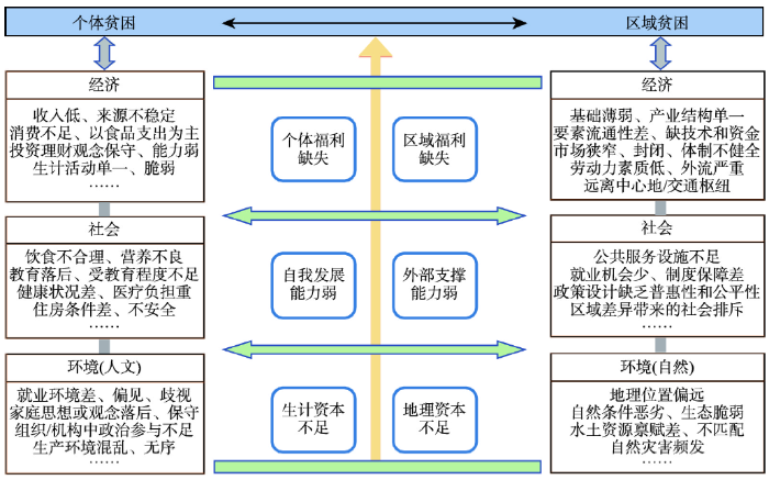 新窗口打开|下载原图ZIP|生成PPT
图1区域贫困与个体贫困的相互作用
Fig. 1Interactions between regional poverty and individual poverty
个体贫困影响区域贫困,区域贫困也会制约个体贫困的减轻。这种相互作用既体现在各自致贫因素的内部,也体现在两者致贫因素之间,通过“资本—能力—福利”的途径相联系。① 个体生计资本不足会限制区域地理资本的获取,而地理资本的劣势则会增加个体生计资本的劣势。例如,村民未能接受良好教育,只能从事低收入行业,他们会选择外出务工,去寻求更高的工资和接受优质教育的机会,农村劳动力素质低、外流严重,出现人口空心化现象,村庄空心化进一步加剧其贫困程度;村庄空心化与贫困化相辅相成,互为因果[54,55]。同时,位置偏远、环境恶劣、生态脆弱等地理资本的劣势也会限制个体生计活动的选择,气候变化、极端灾害的出现使得个体的生计活动和策略变得更加脆弱[56]。② 个体贫困与区域贫困均面临着自我发展能力弱和外部支撑能力弱“两弱”的局面。贫困群体由于受教育程度低、医疗负担重,自我发展能力不足[57];而贫困地区由于资源禀赋差、缺少发展资金和技术投入,区域层面为个体提供的外部支撑能力不足。贫困地区常聚集着大量内生发展能力较弱的个体,而贫困人口则由于缺少区域在资源、资金和政策上的外部支撑,容易出现返贫或陷入持续性贫困[58]。③ 个体福利的缺失会限制区域福利的获取,区域福利的不足也会影响个体福利的增加。当贫困人口由于收入低下、消费不足、住房不安全,个体的衣食住行等基本需求难以满足时,他们也难以获取区域发展政策和制度设计中的福利,不能平等地分享公共服务提升和社会保障完善等发展成果[59,60]。相反,当一个区域位置偏远、远离中心地或交通枢纽时,在制度设计中的地位较低,受经济中心的辐射带动作用较弱,个体就业机会减少、生计选择更加被动,难以满足自身发展需求。
3 贫困地理学学科建设
早在20世纪80年代中国****既已从地理学视角关注贫困问题[19]。2005年国际著名学术期刊Science[61]在创刊125周年时曾提出125个极其重要的、仍未解决的前沿科学问题,其中包括“为什么改变撒哈拉以南非洲贫困状态的努力几乎全部失败?”这一区域贫困问题,使得区域贫困问题的研究长期受到重视。2008年高更和等[26]提出了“穷人地理学”的概念,认为穷人地理学是研究穷人及其贫困问题与自然要素和人文要素的相互关系、相互作用的科学,穷人地理学重点仍是关注人与地理环境的关系。近年来,随着《中国农村扶贫开发纲要(2011—2020)》(简称新扶贫开发纲要)将中国的14个集中连片特困地区作为扶贫攻坚主战场以及精准扶贫战略瞄准贫困村贫困户,区域性贫困问题再一次得到学界高度重视。刘小鹏等[62]明确地提出“贫困地理学”这一专业术语,认为新扶贫开发纲要实施的10年应成为中国贫困地理学发展的黄金期。丁建军等[22]的“区域贫困的地理学分析”一文,为贫困地理学研究奠定了坚实的理论基础。随后,周扬等[21]明确了贫困地理学的定义与内涵、研究范式和关键研究领域,将贫困问题置于特定地域来考量,提出了贫困地域系统的概念,并认为贫困地域系统是贫困地理学的研究核心。3.1 学科性质
贫困地理学(Poverty Geography)是研究贫困地区的形成、分布、地理特征及其与环境的关系和反贫困措施的学科,以贫困地域系统为研究对象,以贫困与环境的关系为研究核心,具有综合性、交叉性和区域性特点[21](图2)。① 综合性。从贫困对象上看,贫困地理学既关注个体贫困,也关注区域贫困;从影响因素上看,既关注地形、气候、资源、灾害等自然要素,也关注人口、技术、市场、收入、就业、教育、医疗、制度等人文要素;从贫困维度上看,包括经济、社会和环境3个维度。② 交叉性。贫困地理学是地理学、经济学和社会学等多个一级学科交叉融合下的一个分支,尤其与发展经济学、贫困经济学和发展地理学等分支学科关系密切。③ 区域性。虽然贫困的主体是“人”,但贫困不只是有个体层面的内因,更有区域层面的外因。换言之,不只是个体由于资本或能力不足而陷入贫困,也有区域层面的劣势使得主体被动地处于贫困状态。贫困地理学的基本研究单元和瞄准对象是地球表层的特定区域,包括行政区、流域、地形区等地理单元。这些地理单元存在空间范围和大小,即空间尺度的差异。关注贫困的空间尺度是贫困地理学的特色与优势,全球、国家、省域、县域、乡镇、村域、社区等多尺度均可以从地理角度进行分析。图2
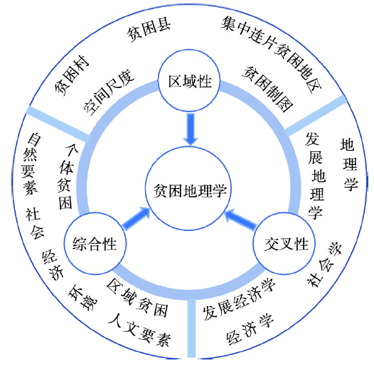 新窗口打开|下载原图ZIP|生成PPT
图2贫困地理学的三大学科特点
Fig. 2Characteristics of poverty geography
贫困地理学是人文与经济地理学的一个分支学科。虽然绝大多数贫困人口分布在农村地区,但是贫困地理学瞄准的是贫困问题,按城乡划分,包括农村贫困和城市贫困。贫困地理学与发展经济学和发展地理学在贫困问题研究上侧重点不同。发展经济学主要是从经济学视角关注贫困人口或群体,而贫困地理学则融合了地理学的空间传统和综合分析优势,侧重于贫困地区的形成机理和减贫路径研究,同时也关注贫困地区的贫困群体的致贫机理。发展地理学是运用地理学的理论观点去研究不同国家或地区的社会经济发展,“发展”是其研究的核心要素,关注所有地区的发展问题[63,64,65]。贫困地理学聚焦贫困地区或欠发达地区的空间分布、致贫机理和减贫路径,重点关注区域贫困与地理环境之间的关系,贫困是贫困地理学研究的核心主题。尽管如此,作为一门交叉学科,贫困地理学在基础研究和学科发展过程中仍需借鉴相关学科的理论和方法,寻求融合与突破。
3.2 基础理论
贫困地理学研究涉及理论较多,从最早的环境决定论开始,衍生出了空间贫困理论、贫困恶性循环理论、多维贫困理论、区域贫困理论、贫困代际传递理论、贫困孤岛效应理论和可持续发展理论等,其中最为核心的基础性理论是空间贫困理论和区域贫困理论。空间贫困理论开创了贫困地理研究的先河,将地理学的空间视角引入贫困研究中。20世纪90年代,地理信息系统技术的出现使得空间要素可视化成为可能,贫困制图成为贫困地理研究的热点。进入21世纪,“空间贫困陷阱”(Spatial Poverty Traps)研究逐渐兴起,并发展成了空间贫困理论的核心。Jalan等[16, 44]首次提出了空间贫困陷阱概念,并从地理资本的视角验证存在空间贫困陷阱。Bird等[38]认为空间贫困陷阱存在于诸多区域劣势所导致的地理资本低、贫困程度高的地方。在21世纪的前10年,英国曼彻斯特大学持续性贫困研究中心(Chronic Poverty Research Centre, CPRC)重点关注全球空间贫困问题,前后发布了两期《持续性贫困报告》[17, 66],汇集了空间贫困研究领域的大批著名****和学术成果。空间贫困理论的核心观点认为,地理位置偏远、自然条件恶劣、生态环境脆弱、公共服务设施不足、政策优惠缺乏的地方,会有大量贫困人口在此集聚,出现持续性贫困而难以摆脱,形成空间贫困陷阱。该理论解释了贫困人口的空间集聚性,受到了学界普遍关注。
区域贫困理论是空间贫困理论的延伸和拓展,将抽象的“空间”具化到现实的“区域”,结合人地关系思想和地域综合体概念来解释区域贫困现象。2013年以来,随着精准扶贫上升为国家重大战略,中国地理****成为区域贫困研究的新生力量和主力军,借助长期从事人地关系研究的优势,在贫困地理学基础理论创新和区域贫困研究中发挥了重要作用。Zhou等[21]明确指出贫困地理研究包括个体贫困和区域贫困两方面,并创新性提出了贫困地域系统的概念,立足于贫困地域系统关注贫困地理分布、形成机理和减贫途径,倡导继承、深化和发展贫困地理学研究。丁建军等[22]从人地关系的视角出发,认为区域贫困是特定时空情景下“人”“地”“业”三者耦合失调的过程和状态。刘小鹏等[62, 67]提出了区域贫困的三维结构和五类地理资本。李寻欢等[4]解晰了区域多维贫困的概念,并从经济贫困、社会贫困和生态贫困3个维度提出了区域多维贫困的测量方法。区域贫困理论将抽象的贫困空间具化为现实世界中包括各类自然和人文要素的地域综合体,继承地理学人地关系研究的传统,认为区域贫困是贫困地域系统发展演化过程中“人”“地”“业”三者耦合失调的外在表现形式,表现在经济、社会和环境3个维度。该理论将个人与区域相结合,为贫困现象的发生、发展以及减贫策略提供了一个综合性解释。
3.3 研究对象
贫困地理学的研究对象是贫困地域系统。人地关系地域系统是地理学研究的核心[68]。贫困地域系统则是人地关系在贫困地域的具体表现形式,是贫困地理学的研究对象和研究核心。贫困地域系统是在特定贫困地域内,由地形、气候、资源、灾害等自然要素和人口、区位、技术、收入、就业、教育、医疗、制度等人文要素所构成的,具有一定结构和功能的复杂系统[4]。从系统结构上看,它包括分别以“人”“地”“业”为核心的社会子系统、经济子系统和环境子系统。贫困地域系统在空间上表现为某个特定贫困地域,例如贫困村、贫困县、集中连片贫困地区等;在内容上表现为“人”“地”“业”三个核心要素的状态与水平,例如居民收入水平、地势起伏度、农业总产值等。贫困地域系统是一个具有耗散结构和远离平衡态的开放系统,它通过与外界不断进行物质交换、能量传递和信息交流。当与外界割裂,要素流动不畅时,区域贫困问题会愈演愈烈;当系统内部以及系统之间要素能自由流动、信息传递通畅时,贫困地域系统会朝着良性方向发展。贫困瞄准是科学有效减贫的基础和前提。2013年底中国开始实施的精准扶贫战略就是在贫困瞄准(贫困村、贫困户)的基础上,通过资金、技术、人员的大量输入,改善贫困地区交通基础设施和公共服务水平,营造良好的发展环境,增强贫困群体内生发展动力,从而实现区域贫困和个体贫困同步减轻。贫困地域系统的演化过程是贫困地区人类系统与自然系统相互作用过程,可借助人与自然耦合系统理论来阐释(图3)。刘建国等[69,70]指出人与自然的耦合就是人类系统与自然系统之间的相互作用,这种相互作用表现在本地系统内部(内部耦合)、本地系统与周边系统(近程耦合)、本地系统与远程系统(远程耦合)3个方面[71]。从区域致贫过程看(图3a),区域贫困问题的发生是由系统内部要素耦合失调以及系统之间要素流通不畅共同造成的。一方面,贫困地区由于教育水平和生育观念落后,人口素质低、增长快,产业结构以种养业、林业、渔业等第一产业为主,产业附加值低,对自然资源的依赖程度高且利用效率低,生态环境在人类毁林开荒等扩张活动中不断恶化,系统内部的“人”“地”“业”等要素呈耦合失调状态。另一方面,贫困地区由于位置偏远、地理环境相对封闭,与周边地区以及发达地区之间的连通性较弱,中青年劳动力、资金等要素流通以单向的对外输出为主且主要流入周边经济相对发达的地区,受远程经济中心的带动作用较弱。在内部要素失调和对外流通不畅两种驱动力的共同作用下,贫困化、老龄化、空心化等问题日益严重。从区域减贫过程看(图3b),贫困程度的减轻就是要探明致贫成因,以协调系统内部要素和畅通系统之间要素的流通为着力点。一方面,贫困地区要大力提高教育、医疗等公共服务水平,提升劳动力素质和技能,引进先进适用技术推动产业转型和升级,节约集约利用水土资源,推进生态保护与修复,使系统内部要素达到耦合协调的状态。另一方面,贫困地区通过加强交通基础设施建设,营造良好的发展环境,与其他周边系统之间的要素流通更加便利;其他周边地区的人口、资金、技术、信息和资源等要素可以自由地进入贫困地区,要素流动方向从单向输出转变为双向自由流动。贫困地区在内部耦合、近程耦合以及远程耦合的共同作用下,内部要素间的协调水平和外部中心地的辐射带动作用显著增强,区域贫困程度逐渐减轻。
图3
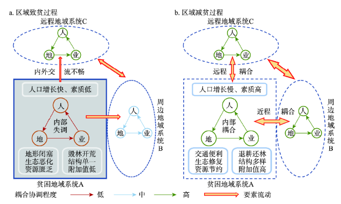 新窗口打开|下载原图ZIP|生成PPT
图3贫困地域系统的演化过程
Fig. 3Dynamics and interactions of impoverished areal system
3.4 研究框架
贫困地理学的研究框架可总结为“3+2+2+2”,即经济、社会和环境3个维度,自然和人文2类要素,个体和区域2类对象,绝对和相对2大标准(图4)。贫困包括经济、社会和环境3个维度,即经济贫困、社会贫困和生态贫困。贫困地理学的研究对象是贫困地域系统,系统之中既有贫困地区(区域)也有贫困人口(个体)。系统的构成要素包括自然地理要素和人文地理要素,其中“人”“地”“业”三个要素分别为社会子系统、环境子系统和经济子系统的核心要素。贫困地理学的基础理论包括空间贫困理论、区域贫困理论和多维贫困理论。贫困地理学研究的核心是贫困与地理环境(自然地理环境/人文地理环境)的关系。这种关系贯穿贫困地理研究的全过程,既包括地理环境对贫困发展演化的影响,也包括贫困的减轻或加深对地理环境变化的响应。贫困地理学研究的最终目标是通过协调“人”“地”“业”三者之间的耦合关系,实现区域可持续减贫与发展。图4
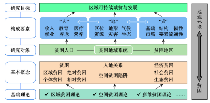 新窗口打开|下载原图ZIP|生成PPT
图4贫困地理学研究的理论框架
Fig. 4Theoretical framwork of poverty geography
3.5 研究内容
贫困地理学重点围绕“6W+H”范式展开研究[21],即什么是贫困(What)?谁贫困(Who)?贫困人口或贫困地区分布在哪里(Where)?为什么贫困(Why)?贫困问题或贫困化什么时候最严重(When)?如何减轻贫困(How)?研究内容主要包括以下3个方面。(1)贫困人口分布格局及其时空演化过程。“贫困人口在哪里”是贫困地理学需要回答的首要问题。格局是认识世界的表观,过程是理解事物变化的机理[72]。深入认识不同空间尺度、不同地域类型贫困人口的分布特征,并在时间上把握其发展演化的状态与过程,有利于揭示贫困地域分异规律,为区域减贫瞄准提供支撑,是贫困地理研究的基础内容。在空间尺度上,按照“全球—国家—省域—县域—乡镇—村域”由大到小的空间单元,运用GIS技术绘制贫困地图,结合空间分析方法解析贫困区域的地理特征(区位/自然条件/生态环境/资源禀赋等),认识并总结贫困人口分布的空间规律。从地域类型看,由于空间差异性或异质性的存在,地理空间常呈现分区或分层的特点,包括不同地貌分区、气候分区、生态分区等。理解贫困人口在不同地域类型的分布规律,是因地制宜、分区分类制定减贫政策的前提和基础。
(2)贫困发生机理及其环境效应。贫困地理学不仅关注贫困人口的空间分布或贫困地区的分布,更要解释贫困发生的空间过程及演化机理,以及地理环境的致贫或减贫效应。在机理层面,可以从贫困的三个维度以及两大致贫要素着手,综合运用田野调查、文献分析、空间统计、计量经济模型、近远程耦合等定性与定量方法,深入挖掘某一特定地理要素与特定贫困维度的作用过程。同时,对特定贫困群体和贫困地区进行长期动态跟踪调查,理清个体贫困与区域贫困相互作用的内在机理,为个体与区域相结合的综合贫困瞄准提供参考依据。贫困瞄准和科学减贫需要自下而上和自上而下的综合贫困精准识别、精准施策和精准帮扶。在效应层面,除了关注地理环境的致贫效应之外,更亟需关注贫困程度的加深或减轻对地理环境的影响。例如,易地扶贫搬迁后迁出地的生态环境有何变化?如何测度易地扶贫搬迁的社会经济效应和生态环境效应或易地扶贫搬迁对乡村生产、生活、生态“三生”空间的重构效应?易地扶贫搬迁在重塑人地关系新格局、促进乡村系统新平衡的作用机理是什么?产业扶贫项目实施过程中产业结构的变化对当地资源利用和环境变化有何影响?贫困地区重大基础设施建设或重大工程的减贫效应;特别需要关注深度贫困地区贫困发生机理和科学减贫或转型发展路径等。这些都是学术界有待深入探究的重要科学议题。
(3)贫困演化的地域模式与减贫策略。服务于地方发展与减贫实践、支撑国家扶贫开发决策是贫困地理学学科发展的重大使命。地理学自古以来就是一门经世致用的学科。面向国家重大战略需求,服务于地方经济发展需要,是当今地理学持续焕发旺盛生命力的根本所在。作为人文与经济地理学的一个分支学科,贫困地理学更应将学科建设需求与地方减贫和发展需要紧密结合。通过对各类典型贫困地域开展长期跟踪调查,总结凝练出科学减贫与持续发展的地域模式。在此基础上,针对当地的地理特征综合利用经济、政策、管理、工程等手段,优化调控和干预贫困地域系统中“人”“地”“业”三者耦合的状态,提炼出不同地域类型有效减贫的经验和途径,为发展中国家减贫战略的制定和地方扶贫决策提供科学依据。
4 贫困地理学研究的前沿领域
2015年联合国在《变革我们的世界:2030年可持续发展议程》中提出了17个可持续发展目标,“消除一切形式的极端贫困”是实现可持续发展目标的首要任务[73]。2020年最新的评估报告指出[74],受新型冠状病毒肺炎疫情的影响,预计2030年全球消除极端贫困的目标将难以实现。从2005年Science杂志提出非洲减贫实践为何失败的疑问,到如今全球减贫面临巨大挑战,这15年来迟迟难以解决的区域贫困问题,或许能从贫困地理学研究中找到答案。为了解决全球区域性贫困问题,当前亟需加强贫困地理学基础前沿领域的相关研究,主要包括以下5个方面。4.1 区域贫困度量与识别
贫困具有区域性、动态性和多维性特征。如何从区域上准确有效地识别贫困地区是当前贫困地理研究面临的首要难题。贫困地理学的核心视角是从空间维度关注区域性贫困问题,最基本的研究对象就是每一个空间贫困单元,例如贫困村、贫困县、集中连片贫困地区、深度贫困地区等。然而,当前贫困地区的瞄准是在贫困人口识别的基础上,通过测算当地的贫困人口规模和贫困人口占比(贫困发生率)等方法识别贫困地区,侧重于经济或收入维度的贫困,贫困的多维特征体现不足。已有研究提出运用BP神经网络模型测量区域多维贫困,为区域贫困的度量提供了一个可行方案[4,5]。但是,该方法在指标选取及其在不同区域的可比性上仍存在不足。区域贫困度量可以通过综合区域发展的现状和特征,如经济发展水平、人民生活水平、资源环境本底和区位条件等,从空间维度测量一个地域单元的贫困程度。在此基础上,对比不同尺度、不同地方的区域贫困程度,按照一定规则确定一个清晰统一的贫困标准,从而识别贫困地区。最后,将从贫困人口出发定义的贫困地区与从空间维度出发识别的贫困地区进行对比、交叉验证,检验识别方法的准确性和有效性,综合评判其可行性。4.2 相对贫困测量与瞄准
当前,中国已经实现现行标准下农村绝对贫困人口全部脱贫、贫困县全部摘帽,未来反贫困工作的重点将由消除绝对贫困转向解决相对贫困[75]。现行标准下贫困人口全部脱贫、贫困县全部摘帽并不意味着贫困的终结,绝对贫困和相对贫困始终会共同存在。贫困县的摘帽正好给贫困地理学研究相对贫困地区或相对贫困人口提供了新机遇,同时也带来了新挑战。服务于建立解决相对贫困体制机制的需要,选择并确定相对贫困的测量方法和识别标准是当前中国贫困研究与减贫决策所面临的紧迫任务,包括相对贫困人口和相对贫困地区两个层面。在相对贫困人口识别层面,国际上常用的方法包括联合国发布的人类贫困指数(Human Poverty Index, HPI)以及按照平均收入占比所设立的相对贫困线(收入平均值或中位数的40%、50%、60%)。作为经济快速转型的发展中国家,中国应当选择怎样的相对贫困线作为相对贫困人口的识别标准,学术界和政府决策者仍处于讨论之中、尚无定论。在相对贫困地区识别层面,相对贫困地区的定义是什么?与“贫困县”“贫困地区”“欠发达地区”“落后地区”等术语在内涵上有何联系与区别?如何在区域贫困度量的基础上识别相对贫困地区?这些都是贫困地理学基础理论与方法研究亟需回答的重要科学问题。4.3 贫困动态监测与模拟预测
开展长时间序列动态监测、获取一手贫困数据和资料,是贫困地理研究通过模型模拟区域贫困现状,预测未来贫困演变趋势,服务支撑减贫战略规划与决策的基础。数据获取与模型模拟是当前贫困地理学研究中面临的两大现实问题与挑战。在数据上,由于缺少专业的贫困数据管理与统计机构,出于数据保密的要求,贫困研究面临着时间不连续、种类不齐全、口径不统一、更新不及时等数据质量问题。为了解决当前贫困地理研究面临的数据问题,着眼于学科持续发展的需要,可以选择一定数量的典型案例区,开展长期的贫困跟踪调查,综合调查资料、统计数据、遥感影像、无人机监测、物联网等多源数据,建立贫困地理数据库。同时,借助大数据、机器学习、数据挖掘等现代技术,打通扶贫主管部门与银行、交通、民政、卫健、公安、住建、人社等部门之间信息沟通的渠道,实现数据共建共享,开展贫困群体动态监测和模拟。在模型方法层面,结合个体贫困和区域贫困,建立科学有效的贫困预测模型,为未来减贫战略的区域瞄准与个体瞄准提供技术支持和参考依据。4.4 城市贫困与农村贫困研究
城市和乡村是不可分割的有机整体[76]。虽然全球大部分贫困人口位于发展中国家的农村地区,但由于快速城市化和城乡人口流动,大量贫困人口将向城市转移,农村贫困人口减少、城市贫困人口增加的贫困城市化现象逐渐出现[77,78],城市贫困成为当前全球面临的重要社会问题[79]。1949年中华人民共和国成立以来,由于贫困人口主要集中在农村地区,中国重点关注的是农村贫困人口的脱贫问题。事实上,由于特定的社会背景,部分城市社会成员由于缺乏必要的资源在某种程度上被剥夺了正常获得生活资料和参与经济社会活动的权利,其生活水平长期低于社会的常规标准,成为城市贫困人口。关信平[80]认为,城市贫困人口是指家庭人均纯收入低于城市居民最低生活保障线以下的人口。目前中国尚无统一的城市贫困人口标准和统计口径,常以民政部公布的全国各城镇中收入在当地政府规定的最低生活保障线以下的非农业人口来衡量城市贫困人口。据民政部《中国民政统计年鉴》(2019)统计数据显示,2018年全国有1007万城镇居民最低生活保障人口[81]。面向2030年可持续发展目标,贫困地理****应加快推进城乡一体的贫困区域瞄准、贫困人口识别标准、减贫或扶贫政策体系和保障机制研究,统筹谋划城市减贫与农村减贫,将绝对贫困线与相对贫困线相结合,探究建立以贫困人口自身发展为主、政策保障为辅的扶贫机制。4.5 贫困地区转型发展与振兴研究
与非贫困地区相比,贫困地区的发展基础更为薄弱,城乡发展不平衡、农村发展不充分的问题更为突出,转型发展的难度更大[82]。亟需要地理****从综合性、动态性和区域性视角,开展区域性贫困的时空格局及其演变机制研究;对标联合国提出的2030年17个可持续发展目标,深入剖析贫困地区转型发展和可持续发展面临的主要问题及其成因,研究贫困地区可持续发展的动力机制、作用路径和地域模式。面向中国全面推进乡村振兴和城乡融合发展战略的历史机遇,贫困地理****应重点关注乡村地域系统可持续发展面临的主要制约因子、系统诊断贫困地区乡村衰退的成因、综合识别衰退乡村的地理分布,划分乡村衰退的地域类型,探究乡村振兴的动力机制,揭示贫困地区精准脱贫与乡村振兴有机衔接的机制和作用路径,特别需要重点研究深度贫困地区持续脱贫和转型发展与振兴的作用机理,设计保障贫困地区转型发展和可持续发展的政策体系和制度体系。同时,要统筹推进农村减贫与城镇化研究,探索农村贫困化、乡村衰退、乡村振兴与新型城镇化耦合作用的机理,为实现城乡融合发展提供理论依据和决策参考。5 结论与讨论
本文深入解析了贫困研究中的核心概念,系统剖析了贫困地理学作为一门分支学科的学科性质、基础理论、研究对象、研究框架与研究内容,并提出了未来贫困地理研究中的几个前沿领域,以期为区域可持续减贫与发展提供理论依据和研究指引。主要观点和结论如下:(1)贫困是指与一定标准相比,人们所享受的各种福利处于劣势、缺少或不足的状态,具有多维性、区域性和动态性。按贫困测量的标准与方法划分,贫困包括绝对贫困和相对贫困。前者表征人们难以满足生理或物质上的最低需要,在贫困测量上更强调“极小值”;后者是指个人或家庭的收入及其所拥有的资源能够满足其基本生活需要,但难以达到社会平均水平,在测量标准上更强调“平均值”。按照瞄准或减贫对象划分,贫困包括区域贫困和个体贫困。个体贫困以微观层面的个体或家庭为瞄准对象,关注个人可行能力的缺失与不足;区域贫困则是以宏观层面的行政区、地区或区域为瞄准对象,从空间出发关注区域层面影响个体福利的各类因素,即个体福利背后的“区域福利”。
(2)贫困地理学是研究贫困地区的形成、分布、地理特征及其与环境的关系和反贫困措施的学科,以贫困地域系统为研究对象,以贫困与环境的关系为研究核心,具有综合性、交叉性和区域性特点。贫困地域系统是在特定贫困地域内,由地形、气候、资源、灾害等自然要素和人口、区位、技术、收入、就业、教育、医疗、制度等人文要素所构成的,具有一定结构和功能的复杂系统,包括经济子系统、社会子系统和环境子系统。贫困地域系统的演化过程是一个人类系统与自然系统交互耦合的过程。贫困地理学的基础性理论是空间贫困理论和区域贫困理论,其研究内容与框架可总结为3个维度(经济/社会/环境)、2大要素(自然/人文)、2类对象(个体/区域)、2大标准(绝对/相对)。
(3)未来贫困地理学应强化区域贫困度量与识别、相对贫困测量与瞄准、贫困动态监测与模拟预测、减贫与扶贫成效评估、贫困地区转型机理与振兴路径等研究内容,重点从人、地、业等要素关注贫困地域系统演化的格局、过程、机理,科学评估不同减贫措施(特别是健康扶贫、科技扶贫、金融扶贫、产业扶贫、教育扶贫等长效扶贫措施)或重大反贫困工程(易地扶贫搬迁、生态扶贫)的减贫效应,系统评估易地扶贫搬迁的社会经济和生态环境效应,评估贫困地域系统应对外界冲击(比如自然灾害、重大公共卫生事件、极端气候事件等)的韧性、脆弱性和适应性。强化巩固脱贫攻坚成果同乡村振兴有机衔接研究,推进建立农村低收入人口和欠发达地区帮扶机制以及防止返贫监测体系。同时,贫困地理****还亟需瞄准联合国2030年17个可持续发展目标,重点关注全球贫困与饥饿、自然灾害之间的关系,共同推进全球减贫、减灾、减少饥饿等目标的实现。
减贫与发展始终是人类社会关注的热点话题。本文从学科建设视角对贫困地理学的基本概念、基础理论、学科性质、研究内容等问题进行了较为全面的探讨。但是,贫困地理学的基础理论研究和学科建设还需各位地理同行的持续贡献,在学术研究和反贫困政策的实践中经受反复的磨练和检验,方能有更大作为。当前,全球经济增长速度逐渐放缓,大量发展中国家经济发展缺乏持续的动力和活力,新冠肺炎疫情(COVID-19)爆发更是增加了全球实现消除极端贫困和饥饿的可持续发展目标的难度。在全球极端气候事件频发的背景下,减贫、减灾、减少饥饿的压力不断增大。为此,亟需强化COVID-19和极端气候事件通过影响人体健康、粮食生产、贸易及国际国内要素流通、经济发展等途径的致贫机理研究,定量评估全球公共卫生事件和气候变化对经济增长和贫困的影响,科学研判联合国2030年可持续发展目标实现的可能性。与此同时,国内经济进入中高速增长的新常态,相对贫困和城市贫困等新问题出现,亟需调整反贫困战略。面对国际国内减贫与发展的新形势新问题,一方面要不断创新和发展贫困地理学的基础理论,开展不同类型区可持续减贫动力机制、可行路径和地域模式研究,构建计量模型模拟并预测未来全球贫困地域系统的演化过程,充分发挥地理学服务于区域可持续发展的传统和优势。另一方面,正如中国著名科学家刘东生先生[83]所倡导的那样,一门新的学科或一个新的研究方向能否成长壮大,取决于人才队伍建设。深化和发展贫困地理学需要平台支持,建议在中国地理学会成立贫困地理学专业委员会,联合“一带一路”减贫与发展联盟、世界银行、亚洲开发银行、联合国粮农组织等国际组织或平台,与其他发展中国家合作开展贫困地理研究和科学考察,加强国际学术研究和人才交流,推动中国贫困地理研究的国际化,为全球消除绝对贫困贡献学科智慧和中国方案。
参考文献 原文顺序
文献年度倒序
文中引用次数倒序
被引期刊影响因子
URL [本文引用: 1]
[本文引用: 1]
URL [本文引用: 1]
URL [本文引用: 1]
DOI:10.11821/dlxb202004007 [本文引用: 12]

Poverty includes regional poverty and individual poverty, both of which are featured by multidimensional concept. Regional multidimensional poverty (RMP) is a major theme and content in poverty geography. Because of harsh natural environment, vulnerable economy and inadequate public services, severely impoverished areas (SIAs) are typical and highlighted areas of RMP, which have been the biggest obstacle to poverty alleviation in China. Based on the theory of spatial poverty, this paper defines the notion of impoverished areal system (IAS) and regional multidimensional poverty (RMP), explores their internal connections and proposes the evaluation indictors and measurement method for RMP. Taking 334 severely impoverished counties as research samples, we analyze the multidimensional poverty patterns of SIAs in 2016 by BP neural network model and exploratory spatial data analysis (ESDA). Results show that: (1) RMP is an external manifestation of the coupling imbalance of "human", "environment" and "industry" in the evolution of IAS. It reveals regional disadvantages in natural environment, economic development and social welfare, corresponding to natural poverty, economic poverty and welfare poverty, respectively. (2) The most severely impoverished county, with the poorest services and infrastructure, is found in the Qinghai-Tibet Plateau. From a single dimension of regional poverty, the Welfare Poverty Index (WPI) > Economic Poverty Index (EPI) > Natural Poverty Index (NPI) in the SIAs, whose average is 2.77, 2.66 and 1.89, respectively, indicating that the lack of social welfare and public services for the poor has become the prominent problem in the SIAs. From the perspective of multidimensional poverty, the Qinghai-Tibet Plateau is a high agglomeration region or "hot spot" of RMP, which is significantly higher than other areas in terms of natural poverty, economic poverty and welfare poverty. (3) Both RMP and individual multidimensional poverty are effective measures of poverty targeting. Their matching coefficient (M) can help us to judge the poverty status of some specific areas, e.g., RMP is superior to individual multidimensional poverty in the remote areas, extremely fragile ecological environment and obvious regional disadvantage, where the matching coefficient (M) is higher. RMP can more objectively reflect the true level of geographical capitals, effectively target poor areas and identify determinant impoverishing factors.
[本文引用: 12]
[本文引用: 4]
[本文引用: 4]
[本文引用: 1]
[本文引用: 1]
[本文引用: 2]
[本文引用: 2]
[本文引用: 2]
DOI:10.2307/135247URL [本文引用: 3]
[本文引用: 1]
DOI:10.1080/0007131032000045923URL [本文引用: 1]
[本文引用: 1]
[本文引用: 1]
[本文引用: 2]
[本文引用: 1]
[本文引用: 3]
[本文引用: 2]
[本文引用: 3]
[本文引用: 3]
DOI:10.11821/yj1988030001 [本文引用: 2]
Poverty and development are serious challenges the world faces now.Because of the natural condition, original base and the diffirent situation of the implementation of polices, disequilibrium situation of the country's economy still exists.Some areas have not yet lifted out of poverty.People's eating and wearing problem has not been completely solved.More than 40 million people are very poor in the country.According to the latesi information, there are all together 664 poor counties in China, excluding Tibet which still Jacks material, about 32 percent of the national total.Most of these areas are revolutionary base areas, areas of minorities, border regions, or mountain areas.The counties are classified in terms of the similarity of physical, social, and economic conditions; the similarity of critical obstacles physical, social, or economic to economic development, and development policies implemented. Six divisions and twenty-one subdivisions can be made as follows. (1) Loess Plateau Poor Areas; (2) Border Zone Between Eastern Plain and Western Mountain Areas. (3) Southwest Karst Mountain Areas; (4) Eastern Hill and Mountain Areas. (5) Qinghai-Tibet Mountain Areas; (6) Inner Mongolian-Xing Jiang Dry Areas.
[本文引用: 2]
[本文引用: 1]
[本文引用: 1]
URL [本文引用: 8]
DOI:10.11821/dlxb201802003 [本文引用: 3]
Owing to the multidimensional and spatial nature of poverty and the synthetic and visible analysis merits of geography science, there is a great potential for geography science, which is taking human-environment relationships as core topics, to understand regional poverty and guide the poverty alleviation practices. This article tries to explain the connotation, inscapes, patterns, formation process and countermeasures in a view of geography science based on the retrospect of geographical research on domestic and abroad poverty. The main conclusions showed that: (1) Regional poverty can be considered as a status or process of deprivation on the three dimensions of "human", "activities" and "environment", or the disharmony among them under the specific situation; (2) The inscapes of regional poverty contain subjective factor ("human"), intermediated factor ("activities") and objective factor ("environment"), and the poverty patterns were caused by the deprivation of the three factors or their imbalanced coupling; (3) The formation process of regional poverty patterns can be understood as a nonlinear negative accumulative cycle of disorderly coupling of subjective factor, intermediated factor and objective factor. At the same time, it can be considered as a phenomenon that the subjective factor ("human") and objective factor ("environment") can not catch up or match the changes of intermediated factor ("activities") during the transitions of human civilization; (4) Synthetical poverty alleviation needs targeted interventions as well as coordination of all countermeasures, which is similar to the consultation of doctors in hospital, which may be a good way to achieve the goal.
[本文引用: 3]
DOI:10.11821/dlxb202104009 [本文引用: 3]
Poverty eradication is a worldwide concern. Regional impoverishment has been considered to be closely related to the geographical environment. Therefore, the relationship between poverty and geographical environment has become the core content of poverty geography. Based on the theoretical basis of regional multidimensional poverty and impoverished areal system, this study constructed a "poverty-environment-economy-society" analytical framework to examine the nexus between poverty and geo-environment. On this basis, taking 124000 poverty-stricken villages as the research object, this study used the methods of spatial autocorrelation, kernel density analysis and geographical detector to depict the spatial geographical pattern of China's poverty-stricken villages in the new era, quantitatively detect the leading factors of the regional differentiation of poverty-stricken villages, and reveal the interaction mechanism between the village impoverishment and the geographical environment. The main conclusions can be drawn in the following three aspects. First of all, poverty and the geo-environment interact with each other, and the paths and manifestations of the interaction between the two are complex and diverse. In general, factors leading to village poverty can be detected from the two categories of nature and humanities and the three dimensions of environment, economy, and society. Environmental factors play a fundamental role in the evolution of poverty, economic factors are the most direct and important contributor to impoverishment, and social factors have a magnifying effect on poverty. Secondly, the distribution of poor villages in China has obvious spatial agglomeration characteristics. The spatial distribution pattern of poverty-stricken villages across the country is consistent with the basic geographic pattern depicted by the Hu Huanyong Line and the three-level topography, with obvious vertical and slope differentiation characteristics. The poor villages in China are spatially distributed with one first-level core area, five second-level core areas and seven third-level core areas. Last but not least, the spatial distribution pattern of poor villages in China is the result of the interaction of multiple factors. Topography, natural resources endowment, labors, transportation and public services were identified as the main contributors to spatial differentiation of poor villages in China. Interaction detection results indicated that the driving force between two-factor interaction is stronger than that of a single factor, and the interaction types are non-linear enhancement except for topographic factors and location. Facing the 2030 UN Sustainable Development Goals, China needs to establish the long-term mechanism to effectively link up poverty reduction, rural revitalization, ecological civilization construction, territorial space optimization and urban-rural integrated development, so as to stimulate the endogenous development momentum of poverty-stricken areas and promote regional sustainable development.
[本文引用: 3]
[本文引用: 2]
[本文引用: 2]
[本文引用: 2]
[本文引用: 2]
DOI:10.13249/j.cnki.sgs.2019.10.008 [本文引用: 1]
Taking Lixin County in Anhui Province as a typical case of plain areas, this article uses spatial autocorrelation analysis on poverty incidences in 361 administrative villages in Lixin County in 2014-2017 to confirm the existence of spatial poverty traps, located in high-high agglomeration areas of poverty incidence. Based on 9 geographical factors, this article use Geodetector model to quantitatively detect the leading factors of rural poverty differentiation in plain areas. The results are as follows: 1) There are also obvious regional differences and spatial agglomeration of poverty incidence in plain areas. Zhangzhuang Village, Jiaqiao Village, Xutian Village, Liuran Village and Lulou Village are the spatial poverty traps of Lixin County, which have been in the "high-high agglomeration" area of poverty incidence for a long time. 2) The second geographical factors, such as location conditions and public services, play a leading role in the differentiation of rural poverty in Lixin County, while the first geographical factors, such as natural environment and resource endowment, play a weak role. Distance to the center of the county, distance to main trunk roads, number of public service points and per capita cultivated land areas are the main factors for the differentiation of rural poverty in Lixin County. 3) The result of interaction detector shows that the driving force of interaction between dominant factors is non-linear. In the practice of Targeted Poverty Alleviation in plain areas, we should attach great importance to the enhancement of the second geographical factors on poverty differentiation, strengthen investment in transportation facilities, rationally allocate public service points to promote the equalization of basic public services and provide basic guarantee for poverty alleviation in plain areas.
[本文引用: 1]
[本文引用: 1]
[本文引用: 1]
[本文引用: 1]
[本文引用: 1]
DOI:10.1146/economics.2020.12.issue-1URL [本文引用: 1]
[本文引用: 2]
[本文引用: 2]
[本文引用: 1]
DOI:10.1126/science.1251875PMID:24855260 [本文引用: 1]
Should income inequality be of concern in developing countries? New data reveal less income inequality in the developing world than 30 years ago. However, this is due to falling inequality between countries. Average inequality within developing countries has been slowly rising, though staying fairly flat since 2000. As a rule, higher rates of growth in average incomes have not put upward pressure on inequality within countries. Growth has generally helped reduce the incidence of absolute poverty, but less so in more unequal countries. High inequality also threatens to stall future progress against poverty by attenuating growth prospects. Perceptions of rising absolute gaps in living standards between the rich and the poor in growing economies are also consistent with the evidence. Copyright © 2014, American Association for the Advancement of Science.
DOI:10.1016/j.jpubeco.2019.07.005URL [本文引用: 1]
[本文引用: 1]
DOI:10.1016/j.jpubeco.2010.11.006URL [本文引用: 1]
DOI:10.1007/s10888-011-9181-4URL [本文引用: 1]
[本文引用: 2]
DOI:10.1016/S0305-750X(97)10015-8URL [本文引用: 1]
DOI:10.1016/j.jrurstud.2017.04.002URL [本文引用: 2]
DOI:10.1016/j.worlddev.2015.10.022URL [本文引用: 1]
DOI:10.1111/0022-4146.00156URL [本文引用: 2]
DOI:10.1073/pnas.0611107104URL [本文引用: 1]
DOI:10.1002/(ISSN)1099-1255URL [本文引用: 2]
[本文引用: 1]
[本文引用: 1]
DOI:10.1016/j.habitatint.2019.102086URL [本文引用: 1]
DOI:10.11821/dlxb201710008 [本文引用: 1]
It is a China's strategic demand to systematically and accurately measure the poverty characteristics of poverty-stricken areas from the perspective of village-level poverty. In this context, this paper constructs a multidimensional poverty evaluation model from the perspective of spatial poverty, and combines the decomposition of indicator contribution degree and linear regression method to explore poverty contributing factors. Then it adopts LSE (Least Square Error) model and geostatistics analysis model to classify the villages' poverty types and spatial distribution difference, so as to grasp the whole poverty characteristics, poverty contributing factors and poverty types of poor villages all over the country and to provide auxiliary decision-making support services for eradicate poverty in 2020. Taking 51461 villages in China as a case, we can draw some conclusions as follows: (1) The distribution of poverty-stricken villages has an obvious regional characteristic from the perspectives of poverty level and poverty size, and most poor villages are concentrated in contiguous destitute areas, showing a pattern of high in the west and low in the east. In view of poverty level, there exists an obvious olive-shaped structure of big in the middle and small on two sides, and nearly half of the poverty-stricken villages are moderately poor. (2) China's poor villages have four main poverty contributing factor dimensions, i.e., harsh transportation conditions, frequent natural disasters, low income and poor labor force qualities, of which, the significant poverty contributing factors are road access ratio, terrain type, suffered frequency of natural disaster, per capita net income, labor force ratio, ratio of illiterate labor forces, etc. (3) China's poor villages are driven by multiple poverty types, among which, those villages with three-factor dominated, four-factor collaborative and five-factor combined types have a relatively high proportion. (4) "Entire-village Advancement" poverty reduction strategy has achieved an initial performance, improved the village's sustainable development environment and raised the income of poor population. However, each village has its own poverty characteristics, therefore, anti-poverty measures should be adjusted according to its respective local conditions.
[本文引用: 1]
[本文引用: 1]
DOI:10.1016/j.landusepol.2017.04.037URL [本文引用: 1]
DOI:10.11821/dlyj020190423 [本文引用: 1]
In response to the UN goal of sustainable development and poverty eradication in 2030, the Chinese government put forward and implemented the national strategy of targeted poverty alleviation in 2014. Scholars have carried out much research from the perspective of poverty factors, poverty types and spatial poverty traps, etc., but the empirical research and policy analysis of specific poverty alleviation measures have not been given enough attention. Based on the data samples of 6378 villages in China, this study analyzed the implementation and progress of the village based assistance measures in the targeted poverty alleviation work, identified the main factors affecting the effectiveness of the village based assistance with the measurement method, and measured the poverty reduction effect of the assistance work. The results show that the first secretary of the village assistance is mainly composed of male cadres sent by county-level units, with an average age of 42 years and education background mainly from universities. During the implementation of the work, the principle of adopting different village strategies according to the needs has been maintained. The specific assistance measures include the development of industry, the cultivation of labor force, the transformation of houses, and the hardening of roads. There are obvious regional differences in the implementation and achievements of these measures. Generally speaking, the poverty alleviation work in the western region is better than that in the central region. The empirical results of the econometric model show that the effect of the assistance work in the village is affected by multiple factors, and the personal characteristics of the first secretary, such as age, education background and work unit, has significant impact on poverty reduction. At the same time, the poverty alleviation measures taken by the task force have a far-reaching significance for improving the public infrastructure in poor areas. The research results will be helpful to provide theoretical basis and decision support for the smooth promotion of the effective connection between targeted poverty alleviation and rural revitalization in China.
[本文引用: 1]
DOI:10.11821/dlxb201506012 [本文引用: 1]
Developing methods for measuring multi-dimensional poverty and improving the accuracy of poverty identification have been the hot topics in international poverty research for decades. In light of the academic thoughts of the vulnerability and sustainable livelihood analysis framework, this paper establishes an index system and a method for geographical identification of multi-dimensional poverty, and carries out a county-level identification in rural China. Furthermore, this study makes a comparison between the identification result, income poverty and the latest designated poor regions by the Chinese government. At last, the identified multi-dimensional poor counties are classified by the similarity of poverty reduction measures. The results show that: (1) Taking the vulnerability and sustainable livelihood analysis framework proposed by DFID as theoretical basis, we build an index system of multi-dimensional poverty identification to reflect the farmers' livelihoods that multiple factors work on. It is feasible to develop a composite Multi-dimensional Development Index (MDI) for the integrated method of geographical identification of multi-dimensional poverty in rural China. (2) A total of 655 counties are identified as multi-dimensional poor counties. They are concentrated and jointly distributed in space, in which the Tibetan Plateau and its neighboring areas of three prefectures in southern Xinjiang, western Loess Plateau, mountainous and gully areas in western Yunnan and Sichuan, are suffering greatly from poverty. Besides, poor counties are mainly in Wumeng-Daliang mountainous areas, Yunnan-Guizhou-Guangxi rocky desertification areas, border mountainous areas in Yunnan, Wuling mountainous areas, Qinling-Daba mountainous areas, Shanxi-Shaanxi gully areas and Yanshan-Taihang mountainous areas. (3) In comparison to the latest designated poor counties, this paper targets at poor counties with more disadvantages at both single and multiple dimensions. Some 71.79% of designated poor counties overlap with identified poor counties. By contrast, the majority of the designated poor counties located in mountainous areas of central or eastern China do not belong to identified poor counties because of much less disadvantage/deprivation dimensions. However, the identified poor counties, which are mainly distributed in marginal areas of plateau or mountainous areas in western China, and suffering from multiple dimensions of disadvantages and deprivations, are not included in the designated poor counties. (4) According to the disadvantage/deprivation situation of different dimensions, multi-dimensional poor counties are classified into eight types, i.e., lack of financial capital, lack of human capital, lack of infrastructure, lack of both financial capital and infrastructure, lack of both human capital and infrastructure, lack of means/strategies of livelihoods, lack of living condition, and lack of development condition.
[本文引用: 1]
DOI:http://www.geog.com.cn/article/2021/0375-5444/10.1186/s12939-020-1121-0URL [本文引用: 1]
DOI:10.13249/j.cnki.sgs.2020.01.007 [本文引用: 1]
Human is the key to social and economic development, and plays a decisive role in rural evolution. However, influenced by urban-rural dual structure, there are large population outflow in rural China, which makes the strategy of rural revitalization lack of human capital support. Therefore, to scientifically promote the implementation of rural revitalization in the new era, it is necessary to study the rural population outflow. Using datasets of 2000 and 2010 population census of the People's Republic of China by county, this research analyzed the evolution and spatial pattern of rural population outflow in China. Then it explored the mechanism of regional differentiation of outflow rate of rural population (ORRP), which was reflected by the ratio of rural hukou-registered population and rural residential population. Results showed that the development of rural population in China from 1978 to present could be divided into three stages i.e., slow development stage (1978-1995), massive outflow stage (1995-2014) and citizenship of agricultural transfer population (since 2014). From 2000 to 2010, ORRP at county level in China generally showed an upward trend, the centralization of rural hukou-registered and residential population declined obviously. From the perspective of spatial pattern, they all showed significant spatial clustering and positive spatial correlation. In 2000, there were 76.06% counties with ORRP ranging from 100% to 150%, and only 14.01% of the counties' ORRP were less than 100%, which were mainly located in Qinghai-Tibet Plateau, Xinjiang and the border areas of northeast China. By 2010, the proportion of counties with ORRP less than 100% fell to 5.20%, concentrating in Xinjiang, and there were also a few counties in Qinghai-Tibet Plateau and Northeast China. Based on pre-selected influencing factors, estimated results of spatial error model (SEM) indicated that elevation, per capita GDP, urban-rural income ratio, proportion of primary industry, urbanization rate, road density, educational attainment and per capita investment in fixed assets were positively correlated with ORRP at county level, while per capita farmland, per capita net income of rural households and ratio of rural employees showed a negative correlation.
[本文引用: 1]
DOI:10.1016/j.habitatint.2020.102161URL [本文引用: 1]
DOI:10.1016/S0305-750X(98)00136-3URL [本文引用: 1]
DOI:10.1016/j.landusepol.2018.12.024URL [本文引用: 1]
DOI:10.1016/S0305-750X(02)00212-7URL [本文引用: 1]
DOI:10.1016/j.worlddev.2004.09.015URL [本文引用: 1]
[本文引用: 1]
[本文引用: 1]
[本文引用: 1]
[本文引用: 2]
[本文引用: 2]
DOI:10.11821/dlxb201910011 [本文引用: 1]
The development of development geography stems from the study of underdeve-lopment and poverty. On the basis of combing the development process, basic theories, analytical models and methods of development geography, and combined with China's academic exploration of regional overall poverty alleviation and localization and poverty reduction of sustainable development, this paper constructs an analytical framework of development geography of poverty in underdeveloped areas, and establishes the "five-in-one" geographical capital index system composed of economic geographical capital, social geographic capital, cultural geographic capital, ecological geographic capital and political geographic capital. The integration method and technical flow of data processing are put forward to analyze the local differentiation of poverty in underdeveloped areas. The results show that: (1) Geographical detection determined the leading geographic capital that plays a role in poverty, and the determinative force of each leading geographic capital on the poverty incidence LA,P ≥ 0.15; (2) Under the action of different dominant geographical capitals, the five single-dimensional geographic capital indexes and their synthetic regional geographic capital indices have obvious local differentiation, and have the characteristics of barrier and time delay; (3) The poor local differentiation can be divided into four types: economic geographical capital constraint, economic-social geographical capital constraint, economic-social-ecological geographical capital constraint, and economic-social-cultural-ecological geographical capital constraint; (4) Based on the characteristics of development, we tap the local dynamics and put forward the targeted countermeasures and models of different types to alleviate local poverty. Under the background of rural vitalization and the 2020 poverty alleviation shift, it is necessary to focus on the comprehensive research on spatial differentiation, spatial diffusion and spatial integration of poverty in less developed areas, so as to provide development geographical solutions for localization and poverty reduction of sustainable development.
[本文引用: 1]
[本文引用: 1]
[本文引用: 1]
DOI:10.11821/dlxb202002002 [本文引用: 1]
In this paper, we review and sort out research progress on development geography since the 20th century, involving its connotation and theory, fields and methods, and development trends in this paper. Specifically, we systematically reviewed the research and application of development geography in the fields such as in the convergence of underdeveloped countries or regions, the convergence in the process of improving the quality of life in developed countries or regions. Then, in line with the analysis of the research progress on development geography in foreign countries, we indicate the development conditions and disciplinary advantages of development geography in China. Further, we pointed that future development geography research in China should focus more on the latest international academic frontier research and national macro-strategic needs. The future research of development geography should be guided by the theory of sustainable development, with the core of improving the sustainable livelihood capacity and regional green development level in underdeveloped areas, and aiming at constructing industrial policy and development geography theory and interdisciplinary integrated research system, and focusing on research on the spatial pattern, diffusion characteristics and convergence mechanism of regional development, to explore the regulatory policies and scientific paths that serve regional economic construction and industrial development.
[本文引用: 1]
[本文引用: 1]
DOI:10.11821/dlxb201703014 [本文引用: 1]
The innovation of spatial poverty measurement method is the key to precisely allocate poverty alleviation resources and improve the quality of rural poverty alleviation. This paper summarized the three-dimensional analysis framework of spatial poverty and constructed the spatial poverty index system at county scale and the method of geographical identification. With Jingyuan county as a study case, the geographical identification of spatial poverty was carried out. The results can be obtained as follows. (1) Spatial poverty index (SPI) in different geographical areas is listed in the order: Plain Area in Valleys Formed by Erosion and Deposition of Rivers (PAVFEDR) (mean value 1.571) > Denudation Structure in Hilly Regions (DSHR) (mean value -0.199) > Erosion Structure in Mountainous Regions (ESMR) (mean value -0.334), indicating that the highest poverty degree is in ESMR, which should be the main area of poverty alleviation. The common feature of spatial poverty in the three geographical areas is economic disadvantage (C4-C7, C17). The main differences are: for PAVFEDR, ecological disadvantage (C25, C16) > economic disadvantage (C5) > location disadvantage (C20) > political disadvantage (C8); for DSHR, economic disadvantage (C5-C7, C17) > location disadvantage > (C18-C20) > ecological disadvantage (C16, C23-C25) > political disadvantage (C8); for ESMR, economic disadvantage (C4-C7, C17) > political disadvantage (C8) > location disadvantage (C18-C20) > ecological disadvantage (C16, C21-C25). (2) The rank of SPI for different ethnic villages is as follows: Han villages (mean value 1.484) > Hui villages (mean value 1.262) > Hui-Han mixed villages (mean value 1.033), indicating that Hui-Han mixed villages at county scale should be the key villages for poverty alleviation. The common feature of spatial poverty in different ethnic villages is the economic disadvantage resulting from the long distance to the nearest market (C17), as well as the ecological disadvantage due to less arable land per capita (C23) and small crop area, especially economical crop area (C24). The main differences of spatial poverty in different ethnic villages are ecological disadvantage resulting from poor living conditions and high disaster loss rate in Han villages, as well as economic disadvantage caused by lack of loans (C5). For Hui villages, it is economic disadvantage caused mainly by low level of knowledge (C12, C13) that leads to the high opportunity cost in entering the market. In Hui-Han mixed villages the differences of production and lifestyle resulted in difficulties in allocation of poverty alleviation resources, consequently the satisfaction rate of poverty alleviation policies (C8) is the lowest for farmers, reflecting that the political disadvantage of spatial poverty is most significant. (3) There are significant differences in spatial poverty among different ethnic villages in the same physical geographical area. The mean values of SPI for Han, Hui, and Hui-Han mixed villages in PAVFEDR are 0.526, 2.557 and 1.644, respectively, which indicates that the Han villages have a high level of poverty and economic disadvantage (C5); the mean values of SPI for Hui and Hui-Han mixed villages in DSHR are 0.321 and -1.934, respectively, which indicates that the poverty level for Hui-Han mixed villages is high, and economic disadvantage (C2, C6, C7) and ecological disadvantage (C16) are both significant; the mean values of SPI in Han, Hui and Hui-Han mixed villages in ESMR are 1.031, -0.029 and -0.842, respectively, which indicates that the poverty level of Hui-Han mixed villages is high, and economic disadvantage (C5-C7, C17), political disadvantage (C8), location disadvantage (C18-C20) and ecological disadvantage (C16, C25) are all present. Therefore, the Han-villages in PAVFEDR, Hui-Han mixed villages in both DSHR and ESMR should be the key villages of poverty alleviation.
[本文引用: 1]
DOI:10.2307/140646URL [本文引用: 1]
[本文引用: 1]
DOI:10.1579/0044-7447(2007)36[639:CHANS]2.0.CO;2URL [本文引用: 1]
DOI:10.1126/science.1144004URL [本文引用: 1]
DOI:10.11821/dlxb202011010 [本文引用: 1]
With increasing global integration, distant coupled human and natural systems have more interactions than ever before, which often lead to unexpected outcomes with profound implications for sustainability. The integrated framework of telecoupling (socioeconomic and environmental interactions over distances) has been proposed to address such cross-border and cross-scale challenges, helping better evaluate and understand telecouplings. We first provide an introduction to the telecoupling framework, including components, definitions, and functions, and then offer an overview of the growing number of telecoupling studies. Particularly, we use three Chinese cases to illustrate the methods, results, significance, and implications of applying the telecoupling framework. We also point out some research gaps and critical unsolved questions in the applications. The telecoupling framework provides a powerful tool to incorporate feedbacks, trade-offs, and synergies across multiple coupled human and natural systems, and helps improve the understanding of distant interactions and the effectiveness of policies for socioeconomic and environmental sustainability across local to global levels.
[本文引用: 1]
DOI:10.11821/dlxb201408002 [本文引用: 1]
Geography is a subject which perceptibly reveals integration and regionalism. The integration means that the diversiform subjects in which geography is involved, and that the regionalism of geography is reflected by the regional differentiation. Through the comprehensive study of the interrelationships among the constituent elements of earth system and the relationship between natural and human systems, it helps us understand the variations of the past, present and future of earth system, and grasp the essence of these changes. Pattern helps us to understand the external features of the world and the process is conducive to the understanding of the internal biophysical mechanism of the world. On the basis of field observations and long-term comprehensive surveys, coupling of patterns and processes at different spatiotemporal scales is an effective way to understand and solve the problems in the field of geography. By analysis of the case studies in the Loess Plateau, the methods of coupling the patterns and processes in the integrated research of geography are discussed and explored.
[本文引用: 1]
[本文引用: 1]
[本文引用: 1]
[本文引用: 1]
[本文引用: 1]
DOI:10.1038/548275aURL [本文引用: 1]
[本文引用: 1]
[本文引用: 1]
DOI:10.18306/dlkxjz.2016.02.006 [本文引用: 1]
Under the background of socioeconomic transition and urbanization in China, regional disparity of urban poverty attracts increasingly more attention of Chinese scholars. Based on poverty data from 352 cities (including prefecture-level cities, prefecture-level districts, autonomous prefectures and leagues) from 2007-2011, this study examines the spatial evolution and distribution of urban poverty, as well as the differences between poverty and economic underdevelopment in China. During the five years between 2007 and 2011, the total number and ratio of urban poor have slightly increased. At the regional level, urban population in poverty and areas where poverty situation has aggravated increased sharply in the western region. Most cities in the eastern area have improved in poverty concentration, while the majority of cities in the western area have deteriorated over this period. At the city level, small cities, resource-based cities, and minority population concentrated cities have also deteriorated. In 2011, poverty ratio showed an increasing trend from east to west. Small and medium-size cities, resource-based cities, and minority population concentrated cities had higher poverty ratio. In resource-based cities in the northeast, there were high poverty ratios but the per capita GDP was high, and the areas were characterized by an "invisible urban poverty". In minority population concentrated cities in the southwest, there were low poverty ratios with low per capita GDP, and the areas were characterized by a "low poverty rate urban poverty". In the future, anti-poverty policymaking should take into consideration location, development condition, and demographic characters of cities. Anti-poverty policies should focus on small and medium-size cities, resource-based cities, and minority population concentrated cities in areas where the urban poverty situation is aggravating and balance the relationship between urban poverty reduction and economic development.
[本文引用: 1]
[本文引用: 1]
[本文引用: 1]
[本文引用: 1]
[本文引用: 1]
DOI:10.11821/dlyj020190644 [本文引用: 1]
Targeting at the needs of Two Centenary Goals, rural development in poverty-stricken areas of China is gradually transforming from poverty alleviation to rural revitalization. Since there is a close relationship between these two stages, targeted poverty alleviation practices in rural areas are of great significance to promote the realization of rural revitalization. This study analyzed the connotations of targeted poverty alleviation and rural revitalization, and investigated the internal logic between them. Then it discussed how antipoverty practices promote the rural revitalization in poverty-stricken areas. Results show that targeted poverty alleviation aims at taking countermeasures to help those who truly need them based on scientific diagnosis of the factors leading to poverty, thus all kinds of factors causing poverty can be eliminated fundamentally. The key of rural revitalization lies in establishing the system and mechanism for urban-rural integrated development, eventually realizing the modernization of agriculture and countryside. In term of the relationship between targeted poverty alleviation and rural revitalization, the former is the key and basic premise of the latter since poverty reduction guided by targeted poverty alleviation makes up the shortboard of rural development, and the latter is the higher stage and guarantee of the former since it steadily improves the abilities of rural sustainable development. Therefore, it can be said that the process of poverty alleviation in rural areas is also a process of gradual rejuvenation of the countryside. Through the rational flow and allocation of factors, such as human, land and capital, poverty-stricken areas have constructed a benign rural regional system with enough elements, proper structure and multiple functions to promote the revitalization of industries, talent, culture, ecology and organizations. Eventually, it helps to achieve the goals of strong agriculture, beautiful countryside and well-off farmers. Rural development has obvious path dependence; thus, its cyclic accumulation effect determines that the current antipoverty in poor areas should focus on the effective connection with rural revitalization, laying a solid foundation for rural sustainable development.
[本文引用: 1]
[本文引用: 1]
[本文引用: 1]
