Geomorphological characteristics of debris flow gullies on the edge of the Qinghai-Tibet Plateau
LIANG Xinyue,1,2,5, XU Mengzhen2, LYU Liqun2,3, CUI Yifei2, ZHANG Fengbao1,41. State Key Laboratory of Soil Erosion and Dryland Farming on the Loess Plateau, Institute of Soil and Water Conservation , CAS and Ministry of Water Resources, Yangling 712100, Shaanxi, China 2. State Key Laboratory of Hydroscience and Engineering, Tsinghua University, Beijing 100084, China 3. Beijing Engineering Research Center of Soil and Water Conservation, Beijing Forestry University, Beijing 100083, China 4. Institute of Soil and Water Conservation, Northwest A&F University, Yangling 712100, Shaanxi, China 5. University of Chinese Academy of Sciences, Beijing 100049, China
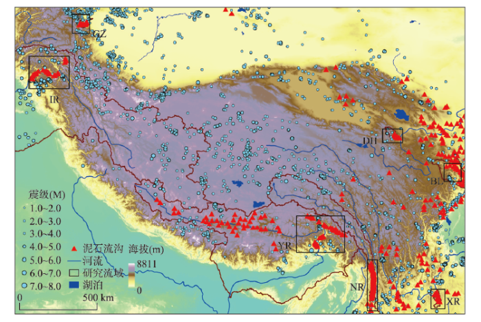
Abstract The edge of the Qinghai-Tibet Plateau is characterized by high topographic relief, significant tectonic motion, extreme precipitation, and densely populated active debris flow gullies. It is essential to scientifically categorize the debris flow gullies to understand their mechanisms, prevent and mitigate debris flow disasters, and find out strategies to restore the ecology. The present study carried out topographical measurements and statistical analyses of seven regions on the edge of the Qinghai-Tibet Plateau, in which active debris flow gullies are concentrated. The debris flow gullies are classified into three types by means of nonmetric multidimensional scaling. Type I is formed by rainstorms in exposed bedrock areas, Type II is formed by glaciers in exposed bedrock areas, and Type III is formed by rainstorms in depositional basins. The variation in landforms of the three types is analyzed using Kruskal-Wallis tests. The sources of loose material and the characteristics of water flow and sediment transport in all the three types of debris flow gullies are discussed from the aspects of geology, topography, and climate. It is shown that the activity of Type II increases along with the warming of the Qinghai-Tibet Plateau, and the activities of types I and III increase along with the frequency of extreme rainfalls. Keywords:Qinghai-Tibet Plateau;categorization of debris flow gullies;nonmetric multidimensional scaling;Kruskal-Wallis test
PDF (7819KB)元数据多维度评价相关文章导出EndNote|Ris|Bibtex收藏本文 本文引用格式 梁馨月, 徐梦珍, 吕立群, 崔一飞, 张风宝. 基于地貌特征的青藏高原边缘泥石流沟分类. 地理学报[J], 2020, 75(7): 1373-1385 doi:10.11821/dlxb202007004 LIANG Xinyue, XU Mengzhen, LYU Liqun, CUI Yifei, ZHANG Fengbao. Geomorphological characteristics of debris flow gullies on the edge of the Qinghai-Tibet Plateau. Acta Geographica Sinice[J], 2020, 75(7): 1373-1385 doi:10.11821/dlxb202007004
LiuC N, DongJ J, PengY F, et al. Effects of strong ground motion on the susceptibility of gully type debris flows Engineering Geology, 2009,104(3):241-253. [本文引用: 1]
ChangT C, ChaoR J. Application of back-propagation networks in debris flow prediction Engineering Geology, 2006,85(3):270-280. DOI:10.1016/j.enggeo.2006.02.007URL [本文引用: 1]
GaoJ, SangY. Identification and estimation of landslide-debris flow disaster risk in primary and middle school campuses in a mountainous area of Southwest China International Journal of Disaster Risk Reduction, 2017,25:60-71. [本文引用: 1]
ZhaoY, MengX, QiT, et al. AI-based identification of low-frequency debris flow catchments in the Bailong River basin, China Geomorphology, 2020: 107125. Doi: 10.1016/j.geomorph.2020.107125. [本文引用: 1]
ZouQ, CuiP, HeJ, et al. Regional risk assessment of debris flows in China: An HRU-based approach Geomorphology, 2019,340:84-102. [本文引用: 1]
MeloR, ZêzereJ L, OliveiraS C, et al. Defining evacuation travel times and safety areas in a debris flow hazard scenario Science of the Total Environment, 2020,712:136452. Doi: 10.1016/j.scitotenv.2019.136452. DOI:10.1016/j.scitotenv.2019.136452URLPMID:31931203 [本文引用: 1] Debris flows are one of the most hazardous types of landslides in mountain regions. In the upper part of the Zezere valley (Serra da Estrela, Portugal) several debris flows events occurred in the last 200 years, some of them causing loss of lives and material damages. In this work, a methodology for pedestrian evacuation modelling, in a debris flow hazard scenario, was implemented. A dynamic run-out model, developed in previous studies, was used to evaluate the debris flows velocities, thickness of the deposits and extent of the mobilized material. The buildings potentially affected by the impact of debris flows were identified and the potentially exposed population was estimated by applying a dasymetric distribution. The results lead to the conclusion that, in the study area, the elderly are those who are most exposed to debris flows. Furthermore, the time lapse between the debris flows initiation and the arrival at the buildings at risk was estimated, allowing to account for the overall number of buildings where the evacuation time takes longer than the debris flows arrival. Additionally, the safe areas within the study area were identified, and several safe public buildings with the capacity to gather a large number of persons were selected. Considering that the study area is located in a mountain region, characterized by steep slopes, the evacuation modelling was performed based on an anisotropic approach, in order to consider the influence of slope direction on travel costs. At the end, three pedestrian evacuation travel time scenarios, based on different walking speeds to accommodate residents with different ages in safer places, were compared and the results mapped. The implemented methodology is not local dependent, which allows its reproduction elsewhere.
RodríguezMorata C, VillacortaS, StoffelM, et al. Assessing strategies to mitigate debris-flow risk in Abancay province, south-central Peruvian Andes Geomorphology, 2019,342:127-139. [本文引用: 1]
MiaoC, LiuX. Characterization of acceptable risk for debris flows in China: Comparison in debris-flow prone areas and nonprone areas International Journal of Disaster Risk Reduction, 2020,42:101405. Doi: 10.1016/j.ijdrr. 2019.101405. [本文引用: 1]
LiuX, MiaoC, GuoL. Acceptability of debris-flow disasters: Comparison of two case studies in China International Journal of Disaster Risk Reduction, 2019,34:45-54. [本文引用: 1]
WinterM G. A strategic approach to debris flow risk reduction on the road network Procedia Engineering, 2016,143:759-768. [本文引用: 1]
ChenH X, LiJ, FengS J, et al. Simulation of interactions between debris flow and check dams on three-dimensional terrain Engineering Geology, 2019,251:48-62. [本文引用: 1]
CucchiaroS, CazorziF, MarchiL, et al. Multi-temporal analysis of the role of check dams in a debris-flow channel: Linking structural and functional connectivity Geomorphology, 2019,345:106844. Doi: 10.1016/j.geomorph. 2019.106844. [本文引用: 1]
ZhaoYan, MengXingmin, ZhengJiaoyu. Application of geomorphological theory in study of debris flow and exploration of its applied theory Journal of Catastrophology, 2017,32(1):43-49. [本文引用: 1]
SinghP, GuptaA, SinghM. Hydrological inferences from watershed analysis for water resource management using remote sensing and GIS techniques The Egyptian Journal of Remote Sensing and Space Science, 2014,17(2):111-121. [本文引用: 1]
ZhangP Z, ShenZ K, WangM, et al. Continuous deformation of the Tibetan Plateau from Global Positioning System Data Geology, 2004,32(9):809-812. [本文引用: 1]
WangZ. Geological environment and sisasters along railway line in the Qinghai-Tibet Plateau Earth Science Frontiers, 2007,14(6):31-37. [本文引用: 1]
HuangJiangcheng, OuGuoqiang, PanHuali. Geomorphic evolution of comparison on debris flow gullies in Bailongjiang and Xiaojiang basins The Chinese Journal of Geological Hazard and Control, 2014,25(1):6-11. [本文引用: 1]
YaoTandong, YuWusheng, WuGuangjian, et al. Glacier anomalies and relevant disaster risks on the Tibetan Plateau and surroundings Chinese Science Bulletin, 2019,64(27):2770-2782. [本文引用: 1]
SeongY B, OwenL A, YiC, et al. Geomorphology of anomalously high glaciated mountains at the northwestern end of Tibet: Muztag Ata and Kongur Shan Geomorphology, 2009,103(2):227-250. [本文引用: 1]
WangJie, ZhouShangzhe, ZhaoJingdong, et al. Quaternary glacial geomorphology and glaciations of Kongur Mountain, eastern Pamir, China Scientia Sinica (Terrae), 2011,41(3):350-361. [本文引用: 1]
ZhaoXin, ChengZunlan, LiuJiankang, et al. Hazard degree assessment on site-specific debris flows in Dongchuan of Yunnan Province Journal of Catastrophology, 2013,28(1):102-106. [本文引用: 1]
DuJun, WangZhaoyin, LiZhiwei, et al. A preliminary study on spinulose stream networks in the Tongde Basin of the Yellow River source Journal of Arid Land Resources and Environment, 2014,28(2):129-135. [本文引用: 1]
YangDayuan, WuShengguang, WangYunfei. On river terraces of the upper reaches of the Huanghe River and change of the river system Scientia Geographica Sinica, 1996,16(2):137-143. [本文引用: 1]
SinghP, ThakurJ K, SinghU. Morphometric analysis of Morar River Basin, Madhya Pradesh, India, using remote sensing and GIS techniques Environmental Earth Sciences, 2013,68(7):1967-1977. [本文引用: 1]
DaiF C, LeeC F. Landslide characteristics and slope instability modeling using GIS, Lantau Island, Hong Kong Geomorphology, 2002,42(3):213-228. [本文引用: 1]
AbdallahC, ChorowiczJ, BouKheir R, et al. Detecting major terrain parameters relating to mass movements' occurrence using GIS, remote sensing and statistical correlations, case study Lebanon Remote Sensing of Environment, 2005,99(4):448-461. [本文引用: 1]
WanS, LeiT C, HuangP C, et al. The knowledge rules of debris flow event: A case study for investigation Chen Yu Lan River, Taiwan Engineering Geology, 2008,98(3):102-114. [本文引用: 1]
PikeR, WilsonS. Elevation-relief ratio, hypsometric integral, and geomorphic area-altitude analysis Geological Society of America Bulletin, 1971,82(4):1079-1084. [本文引用: 1]
JiangZhongxin. A statistical analysis on longitudinal profile shape of debris flow valley along Palongzangbu River in Tibet The Chinese Journal of Geological Hazard and Control, 2001,12(4):41-47. [本文引用: 1]
BasuT, PalS. RS-GIS based morphometrical and geological multi-criteria approach to the landslide susceptibility mapping in Gish River Basin, West Bengal, India Advances in Space Research, 2019,63(3):1253-1269. [本文引用: 1]
LiZhiqiang, LiWeiquan, ChenZishen, et al. Influencing factors and classifications of arc-shaped coasts in South China Acta Geographica Sinica, 2014,69(5):595-606. [本文引用: 1]
YangZhigang, Zhuoma, LuHongya, et al. Characteristics of precipitation variation and its effects on runoff in the Yanglung Zangbo River basin during 1961-2010 Journal of Glaciology and Geocryology, 2014,36(1):166-172. [本文引用: 1]
ZhangWancheng, XiaoZiniu, ZhengJianmeng, et al. Characteristics of the Nujiang River runoff for a long term and its response to climate change Chinese Science Bulletin, 2007,52(Suppl.II):135-141. [本文引用: 1]
TateE L, FarquharsonF A K. Simulating reservoir management under the threat of sedimentation: The case of Tarbela Dam on the River Indus Water Resources Management, 2000,14(3):191-208. DOI:10.1023/A:1026579230560URL [本文引用: 1] The useful life of Tarbela reservoir, on the River Indus, is threatened by a sediment delta which is approaching the dam'sintake tunnels; these lead to a hydroelectric power station and are used for irrigation releases. This article describes thesimulated system, involving Tarbela Dam, with Ghazi Barotha hydropower scheme downstream, and the planned construction of Basha Dam upstream. This study formed an innovative approachwhich enabled the relationship between demands and supply in the basin to be studied, under a range of development and operating scenarios, and to different time horizons. A computer software package, 'Hydro', was used to perform systemsimulation modelling of Tarbela Dam and the Upper Indus Basin,Pakistan. The results enabled estimation of the economic benefits of several potential future operating strategies forTarbela to be tested and compared. Employing the results of associated sediment modelling, projected storage/elevation curves were used to predict the irrigation and power benefitsavailable to Pakistan over the coming sixty years. It wassubsequently demonstrated that the most beneficial remedial measures are an underwater dike or dam to protect the intakes,and low-level flushing facilities.]]>
TangC, JiangZ, LiW. Seismic landslide evolution and debris flow development: A case study in the Hongchun Catchment, Wenchuan area of China Engineering Geology for Society and Territory, 2015,2:445-449. [本文引用: 1]
TangC, ZhuJ, LiW L, et al. Rainfall-triggered debris flows following the Wenchuan earthquake Bulletin of Engineering Geology and the Environment, 2009,68(2):187-194. [本文引用: 1]
XuM, WangZ, QiL, et al. Disaster chains initiated by the Wenchuan earthquake Environmental Earth Sciences, 2012,65(4):975-985. [本文引用: 1]
WangZ, CuiP, WangR. Mass movements triggered by the Wenchuan earthquake and management strategies of quake lakes International Journal of River Basin Management, 2009,7(4):391-402. [本文引用: 1]
CuiPeng, WeiFangqiang, ChenXiaoqing, et al. Geo-hazards in Wenchuan earthquake area and countermeasures for disaster reduction Bulletin of the Chinese Academy of Sciences, 2008,23(4):317-323. [本文引用: 1]
TangChuan. Activity tendency prediction of rainfall induced landslides and debris flows in the Wenchuan Earthquake areas Mountain Research, 2010,28(3):341-349. [本文引用: 1]
ChengW, WangN, ZhaoM, et al. Relative tectonics and debris flow hazards in the Beijing mountain area from DEM-derived geomorphic indices and drainage analysis Geomorphology, 2016,257:134-142. [本文引用: 1]
HackJ T. Stream-profile analysis and stream-gradient index Journal Research of United States Geological Survey, 1973,1(4):421-429. [本文引用: 1]
SeeberL, GornitzV. River profiles along the Himalayan arc as indicators of active tectonics Tectonophysics, 1983,92(4):335-367. [本文引用: 1]
NefesliogluH A, DumanT Y, DurmazS. Landslide susceptibility mapping for a part of tectonic Kelkit Valley (Eastern Black Sea region of Turkey) Geomorphology, 2008,94(3):401-418. [本文引用: 1]
GokceogluC, SonmezH, NefesliogluH A, et al. The 17 March 2005 Kuzulu landslide (Sivas, Turkey) and landslide-susceptibility map of its near vicinity Engineering Geology, 2005,81(1):65-83. [本文引用: 1]
KimS, SharmaA. The role of floodplain topography in deriving basin discharge using passive microwave remote sensing Water Resources Research, 2019,55(2):1707-1716. [本文引用: 1]
LyuLiqun, WangZhaoyin, XuMengzhen, et al. Geomorphic characters of debris flow fans along Nu River and the river blocking mechanisms Journal of Hydraulic Engineering, 2016,47(10):1245-1252. [本文引用: 1]
ComitiF, MaoL, PennaD, et al. Glacier melt runoff controls bedload transport in alpine catchments Earth and Planetary Science Letters, 2019,520:77-86. DOI:10.1016/j.epsl.2019.05.031URL [本文引用: 1]
WangC, GuoY. Precipitable water conversion rates over the Qinghai-Xizang (Tibet) Plateau: Changing characteristics with global warming Hydrological Processes, 2012,26:1509-1516. [本文引用: 1]
YaoTandong, WuGuangjian, XuBaiqing, et al. Asian water tower change and its impacts Bulletin of the Chinese Academy of Sciences, 2019,34(11):1203-1209. [本文引用: 1]
XuFei, JiaYangwen, NiuCunwen, et al. Variation character of annual, seasonal and monthly temperature and precipitation Mountain Research, 2018,36(2):171-183. [本文引用: 1]
LiLin, LiXiaodong, XiaoRuixiang, et al. The heterogeneity of climate change and its genesis in the northeastern Qinghai-Tibet Plateau Journal of Natural Resources, 2019,34(7):1496-1505. [本文引用: 1]
 ,1,2,5, 徐梦珍2, 吕立群2,3, 崔一飞2, 张风宝1,4
 新窗口打开|下载原图ZIP|生成PPT
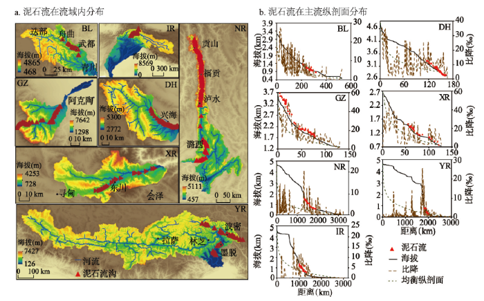 新窗口打开|下载原图ZIP|生成PPT
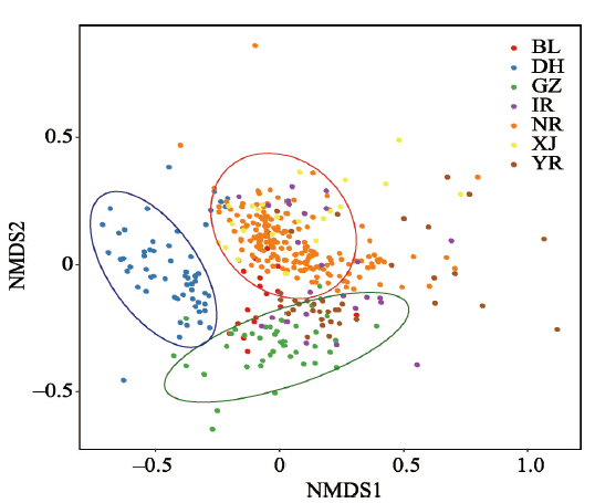 新窗口打开|下载原图ZIP|生成PPT
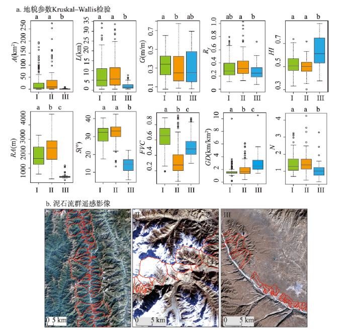 新窗口打开|下载原图ZIP|生成PPT
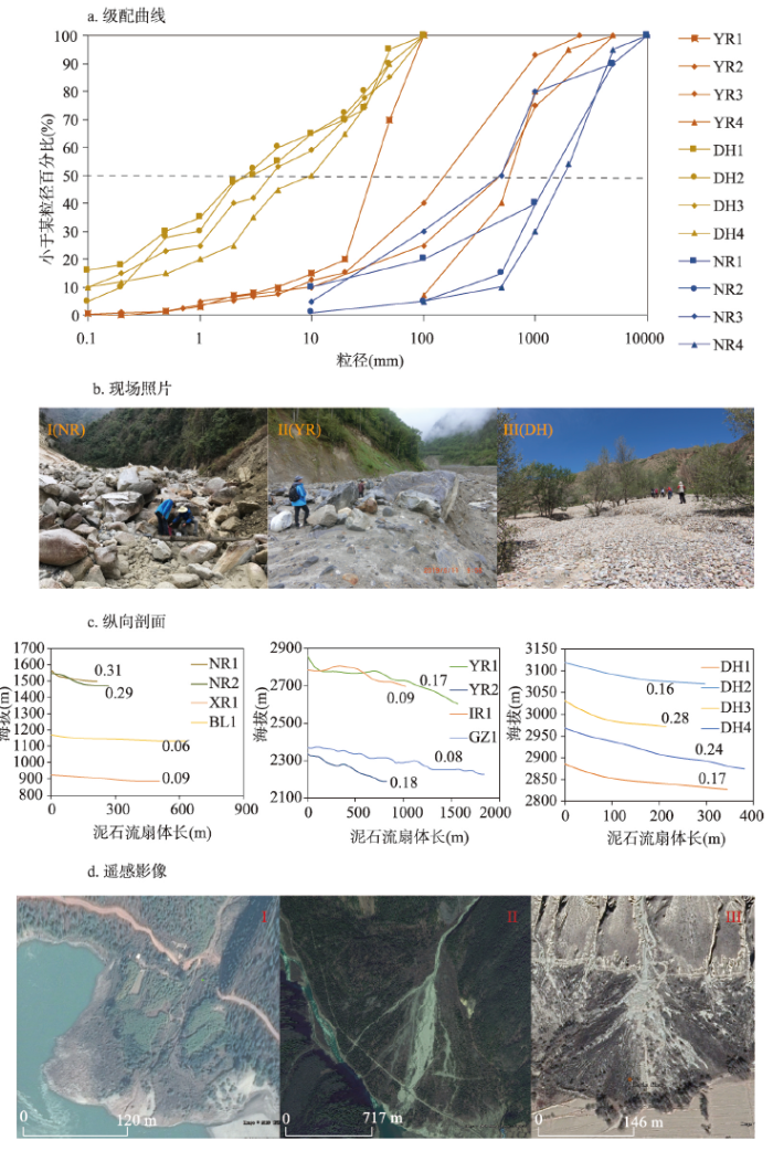 新窗口打开|下载原图ZIP|生成PPT
 新窗口打开|下载原图ZIP|生成PPT
 新窗口打开|下载原图ZIP|生成PPT
