 ,1,2, 王会蒙1,2, 杜云艳,1,2, 易嘉伟1,2, 刘张1,2, 涂文娜1,2
Spatiotemporal patterns of in- and out-bound population flows of the Qinghai-Tibet Plateau
WANG Nan,1,2, WANG Huimeng1,2, DU Yunyan,1,2, YI Jiawei1,2, LIU Zhang1,2, TU Wenna1,2通讯作者:
收稿日期:2019-04-2修回日期:2020-06-28网络出版日期:2020-07-25
| 基金资助: |
Received:2019-04-2Revised:2020-06-28Online:2020-07-25
| Fund supported: |
作者简介 About authors
王楠(1994-), 女, 硕士生, 研究方向为时空数据挖掘。E-mail:

摘要
关键词:
Abstract
Keywords:
PDF (5005KB)元数据多维度评价相关文章导出EndNote|Ris|Bibtex收藏本文
本文引用格式
王楠, 王会蒙, 杜云艳, 易嘉伟, 刘张, 涂文娜. 青藏高原人口流入流出时空模式研究. 地理学报[J], 2020, 75(7): 1418-1431 doi:10.11821/dlxb202007007
WANG Nan, WANG Huimeng, DU Yunyan, YI Jiawei, LIU Zhang, TU Wenna.
1 概述
由于青藏高原特殊的气候和地形条件,以往的青藏高原地广人稀,人迹鲜至[1,2,3]。自21世纪以来,随着青藏铁路及公路等基础设施的不断改善,国内外游客数量猛增[4,5,6],且大都在气候适宜的夏季涌入,呈现出明显的客流量淡旺季变化模式[7,8],游客短时间的集中涌入不仅带来了特定时段经济的增长、劳动力需求的增加[9],也对青藏高原脆弱的生态环境带来一定的冲击,明确青藏高原的人口流动模式成为城市区域发展规划、旅游管理和生态环境保护的迫切需求。此外,人口流动作为区域间物质流、信息流、资本流、技术流的重要载体[10],反映了区域之间的吸引、包容及扩散等交互能力,开展青藏高原人口流入和流出的时空规律,探讨其与国内其他城市的人口交互模式,是进一步认识青藏高原的空间发展特征及影响的重要手段,为科学制定青藏高原发展战略提供重要参考价值。受人口数据可得性的限制,目前青藏高原人口流动研究主要采用人口普查、统计年鉴及问卷调查等数据,从人类学、社会学和人口学等方面开展局部区域的人口流动特征及影响因素分析[11,12,13,14]。如王树新[15]从人口学的角度给出西藏自治区人口迁徙所经历的多个阶段及五普后的人口迁徙状况;朱玉福[16]等分析讨论了青藏铁路通车后西藏自治区流动人口带来的社会治安、生态环境和文化保护等问题;钟振明[17]分析了西藏流动人口的构成与特点并提出完善西藏流动人口管理与服务的相关建议。随着多次人口普查任务的完成,诸多****在不同区域以不同视角开展了西藏、青海或者藏区人口流动的综合分析及与城镇化进程的关系[18]。上述研究虽然一定程度上摸清了西藏和青海人口流动基本特点及问题,但由于受普查数据更新速度限制,难以研究城市间人口交互的复杂变化和网络特征,进而难以揭示青藏高原人口流动整体的时空模式,更谈不上通过人口流动来解析其区域发展及影响力。
随着互联网与通讯技术的发展,智能手机定位、社交媒体签到、视频与图片等位置大数据提供了新颖且快速感知人类移动的网络大数据,为开展城市间交互网络研究带来了契机[19]。当前采用移动网络数据开展的研究主要侧重于不同尺度的人口流动网络特征、流动格局以及假日期间人口流动的模式变化等[16,17,18,19,20,21,22]。如Belyi等在全球尺度探讨国家间人口流动的短期格局和长期格局[20];刘望保等[21]给出了中国人口日常流动格局及与“胡焕庸线”的关系;Lin等[22]从复杂网络角度运用多源大数据分析了珠三角城市网络结构的连通性;Naaman等[23]利用社交媒体数据分析了美国城市网络的活动等级及交互联系;魏冶等[24]从对外联系度、优势流和城市位序等维度解析转型期中国城市的网络特征;赵梓渝等[25]利用百度迁徙数据,借助重力模型推算春节期间人口省际流动格局及影响变量;Xu等[26]基于腾讯迁徙数据进行的中国城市网络的分析研究发现了春节期间中国地级市间人口的不平衡流动,揭示了城市间人口流动的交互方向。上述研究已经充分表明了移动网络数据凭借高精度的时空分辨率用于多尺度人口流动模式研究的可行性和有效性,为城市规划和发展提供了大量的政策建议。但上述研究从时间序列来看相对较短,大多集中在某段时间内城市间人口交互一般规律及格局的挖掘,缺乏城市交互的周期性或季节性变化模式的系统分析及原因分析。
因此,本文从青藏高原人口流动模式的研究需求出发,结合腾讯迁徙大数据,采用时间序列分析方法开展青藏高原与全国其他城市人口流动的时空交互模式研究,并利用复杂网络方法分析青藏高原在全国的影响力及地位,进一步探讨交互模式的驱动因素。研究结论能够揭示青藏高原与全国的人口流动的时空模式,针对城市交互的空间格局制定科学的、可行的发展政策,并为促进青藏高原的整体协调发展提供一定的参考依据。
2 研究区域与数据
2.1 研究区域
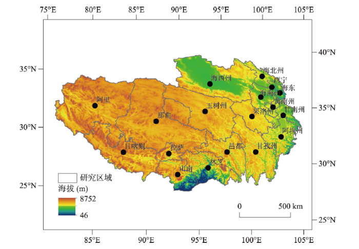
本文的研究区青藏高原[27]主要城市包括:拉萨、日喀则、昌都、林芝、山南、那曲、阿里地区、西宁、海东以及海北、黄南、海南、海西、果洛、玉树、甘南、甘孜和阿坝等18个地级市(全部或90%包含在青藏高原边界内)。研究区国土面积约为216万km2。2.2 人口迁徙数据
人口迁徙数据来自腾讯位置大数据网站(https://heat.qq.com/)。利用“腾讯迁徙”平台的API,获取2015年2月—2018年10月全国365个城市逐日的迁徙数据(包含起点城市、终点城市和具体迁徙人数)。该数据集所含的365个城市包括:333个地级市、4个直辖市、26个县级市、2个特别行政区(香港和澳门),其中,包含研究区所选的18个地级市。该数据集已多次用于城市间人口流动研究,并已验证了数据有效性[26]。本文利用该数据集重构了青藏高原与347个城市之间的人口迁徙矩阵。图1
 新窗口打开|下载原图ZIP|生成PPT
图1研究区域概况
Fig. 1The overview of the Qinghai-Tibet Plateau
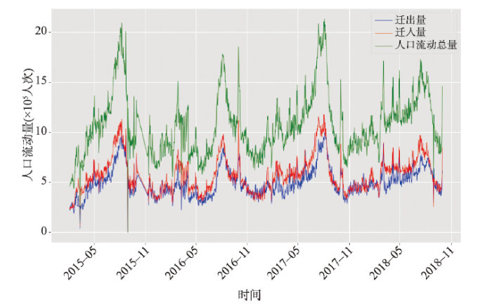
将青藏高原视为人口流动网络的一个节点,将剩余347个城市分别视为人口流动网络节点。以日为单位,将城市人口迁徙量作为节点之间的网络关系,构造348×348的流动网络矩阵,形成全国人口流动网络(Population Mobility Network of China, PNC)。借助PNC网络,统计青藏高原逐日流入、流出、流动人口总量的时序变化特征(2015.05—2018.10),如图2所示,其中,日均流入人口和日均流出人口数量分别约为50万人次和57万人次,日均流动人口的最大值超过200万人次,年内呈现出显著的周期性变化特征。
图2
 新窗口打开|下载原图ZIP|生成PPT
图2青藏高原逐日人口流入、人口流出、人口流动数量的时序变化特征图
Fig. 2Time series of the inflow, outflow and total flow of population on the Qinghai-Tibet Plateau
3 研究方法
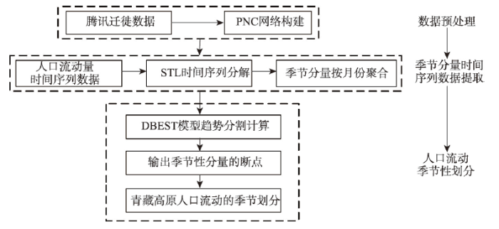
本文采用的数值分析方法包括:时间序列分解和断点检测、社会网络分析和相互作用关系模型。时间序列分解和断点检测法用于探究青藏高原季节性人口流动模式;社会网络分析方法用于评价PNC网络中青藏高原的重要性;采用网络节点相互作用关系模型,计算PNC网络中青藏高原与国内主要城市间的联系强度;利用韦尔奇T-检验方法,开展青藏高原与其他城市联系的时空差异显著性检验。3.1 时序数据的季节划分方法
以鲁棒局部加权回归作为平滑方法的时间序列分解方法(Seasonal-Trend Decomposition based on Loess, STL)是基于鲁棒局部加权回归(Loess)算法将时序数据分解为趋势分量Trend Component)、季节分量(Seasonal Component)和余项(Remainder Component)。由图2可知,青藏高原人口流动量的时序数据呈现出明显的周期性季节变化特征,不同季节之间的人口流动特征存在显著差异,因此本文利用STL方法分解青藏高原人口流动量的逐日时序数据,提取青藏高原人口流动的季节分量;针对季节分量,利用断点检测和趋势分割估计模型(Detecting Breakpoints and Estimating Segments in Trend, DBEST)[28,29]完成断点检测(DBEST模型根据给定阈值获取季节分量时序数据中的断点),实现青藏高原人口流动模式的周期性季节划分。具体方法流程详如图3所示。图3
 新窗口打开|下载原图ZIP|生成PPT
图3青藏高原人口流动季节划分流程图
Fig. 3Flow chart of seasonal division by population mobility of the Qinghai-Tibet Plateau
3.2 人口流动网络分析方法
3.2.1 PNC网络节点城市重要性评价模型 文中采用PageRank算法评价青藏高原节点在PNC网络中的重要性。通常越重要的网络节点往往拥有与其他网络节点越多的链接。PageRank算法借助“链接流行度”这一指标,实现网络节点重要性排序。与传统社会网络分析方法中普遍采用的节点中心性指标(度、介数和接近中心性等)相比,“链接流行度”不仅考虑了网络节点的连接数量,而且计算了与被考察的网络节点相连节点的质量,重要性高的网络节点获得更多节点的连接和更多的来自其他重要网络节点的连接[26, 30-31]。各个城市节点利用PageRank算法中“链接流行度”的计算公式如下:式中:PRi为城市节点
3.2.2 PNC网络节点城市之间人口流动联系强度计算模型 虽然网络节点城市之间的迁徙量能初步反映两地之间人口流动联系强度,但受城市自身人口基数(规模)影响,两座节点城市之间的人口流动绝对量并不能准确反映两座节点城市之间的人口相互作用强度。为此,文中采用了Sforzi等提出的相互作用关系模型[31],来计算任意两座节点城市之间的人口流动联系强度,进而定量刻画青藏高原与其他城市之间的人口流动联系强度:
式中:IVij是城市i与城市j之间的人口流动联系强度;fij和fji分别代表从城市i到城市j和城市j到城市i的流动人口数;Oi和Oj分别是城市i和城市j的总的迁出人口数;Ii和Ij分别是城市i和j总的迁入人口数。
4 研究结果
4.1 青藏高原人口流动的时间模式
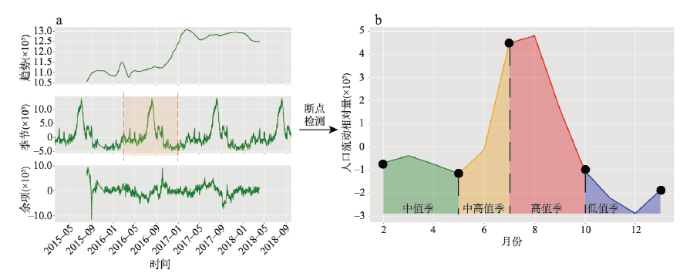
4.1.1 青藏高原人口流动的周期性季节变化模式 研究发现了青藏高原人口流动的周期性季节变化模式。图4a分别给出了青藏高原人口流动的趋势分量、季节分量和残差分量。从趋势分量看,青藏高原人口流动呈现上升趋势;从季节分量看,呈现周期性年际变化。把季节分量的一个年周期按月聚合后做断点检测(图4),检测出2月、5月、7月和10月共4个断点,故每年可划分为4个季节(考虑国庆黄金周呈现人口流动数量峰值,故将国庆黄金周归入7—10月迁徙季)。每年的7—10月为人口流动高值季(High),流动总量达到最大峰值;10月到来年1月为人口流动低值季(Low),人口流动量骤减,并进入低谷状态;2月、3月、4月为人口流动的中值季(Medium),流量开始回升并维持稳定;5—6月为人口流动中高值季(Mid-High),呈持续增加态势且流动量仅次于高值季。为了进一步验证季节划分的有效性,对4个季节人口流动年均量进行显著性差异检验(表1),结果表明在0.01的显著性水平上4个季节之间的差异全部通过显著性检验,进一步验证了青藏高原人口流动的周期性季节变化模式。图4
 新窗口打开|下载原图ZIP|生成PPT
图4青藏高原人口流动季节的划分结果图
Fig. 4Results of the seasonal division by population mobility of the Qinghai-Tibet Plateau
Tab. 1
表1
表1青藏高原人口流动季节性的显著性检验结果(T值/P值)
Tab. 1
| 低值季 | 中值季 | 中高值季 | 高值季 | |
|---|---|---|---|---|
| 低值季 | 0/1 | -8.32/< 0.001 | -15.14/< 0.001 | -23.06/< 0.001 |
| 中值季 | 8.322/< 0.001 | 0/1 | -5.56/< 0.001 | -16.51/< 0.001 |
| 中高值季 | 15.14/< 0.001 | 5.56/< 0.001 | 0/1 | -10.22/< 0.001 |
| 高值季 | 23.06/< 0.001 | 16.51/< 0.001 | 10.22/< 0.001 | 0/1 |
新窗口打开|下载CSV
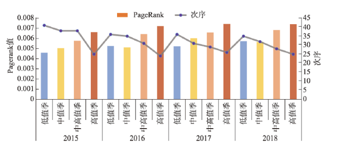
4.1.2 青藏高原在PNC网络中重要性排名的季节变化特征 2015—2018年青藏高原的节点重要性逐年升高,青藏高原的PageRank值总体提升了16.3%(图5)。青藏高原的重要性排序总体上升了5位,其中低值季上升6位,中值季上升6位,中高值季上升9位,高值季上升1位,说明青藏高原对其他节点城市的吸引力不断加强,且不同季节均有所提升。
图5
 新窗口打开|下载原图ZIP|生成PPT
图5青藏高原在PNC中的PageRank值及其重要性位置排序变化
Fig. 5PageRank values of the Qinghai-Tibet Plateau nodes and their positional changes in the PNC
从低值季—中值季—中高值季—高值季,其PageRank值与重要性位次依次为0.0052(36)、0.0055(32)、0.0064(30)和0.0071(24)。高值相比于低值季,PageRank值提升37.9%,重要性位序排名提升12位,呈现显性的增高(T检验值为5.876,在0.05置信水平上通过检验),与所划4个季节的平均气温(-6.0 ℃、-3.8 ℃、8.8 ℃、10.3 ℃)高度相关(Person相关系数为0.965,p < 0.05),说明气温的季节性变化对青藏高原人口流动有显著的限制作用。
4.2 青藏高原人口流动的空间模式
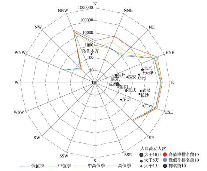
4.2.1 青藏高原人口流动方向的空间模式 在4个季节中,青藏高原与其他城市之间人口流动总量的80%都来自于排名前12位的城市,因此,本节重点分析与青藏高原有人口流动的14个主要城市的流动状况(图6)。其中,成都、北京、西安、兰州、长沙、武汉、重庆、乌鲁木齐、昆明和郑州等城市与青藏高原的人口流动数量全年最多;在高值季,广州、天津与青藏高原的人口流动数量排进了前10名;在低值季,临夏、绵阳与之呈现高的人口流动量。图6
 新窗口打开|下载原图ZIP|生成PPT
图6青藏高原人口流动方向统计特征图
Fig. 6The statistical characteristics of the Qinghai-Tibet Plateau for population mobility in different seasons and directions
14个重点城市与青藏高原人口流动交互总量的分布包括4个区域(图6)。一区是稳定高流量区域,分布在青藏高原的ENE-ESE的扇形区内,4个季节人口流动总量占比分别为91.4%、90.8%、91.9%、89.8%。二区分布在青藏高原的ENE-NNW的扇形区内,人口流动总量整体下降且存在较大的季节性波动。三区位于ESE-SE的扇形区内,人口流动总量与二区相当,但季节变化不明显,昆明为本区主要目标城市;四区分布在青藏高原的NNW-WNW扇形区内,全年人口流动总量均很低,人口流动量占比分别为0.92%、1.1%、0.81%、0.85%。
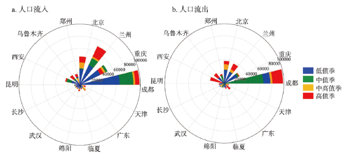
图7a、图7b分别为青藏高原与14个重点城市不同季节流入和流出量的极坐标图。可以看出流入和流出基本上保持相似的规律,大部分城市呈现低值季—中值季—中高值季—高值季的递增规律,但重庆较为特殊,在中值季呈现流入峰值而在中高值季呈现流出高峰,流入数量相对流出的要大,推测是服务业劳务输入的原因。成都、兰州相对其他城市与青藏高原的人口流动量较高,主要原因为这两个城市是通往西宁和拉萨的主要交通中转地,而北京、西安、乌鲁木齐和郑州在流入量和流出量上均属于第二个级别。
图7
 新窗口打开|下载原图ZIP|生成PPT
图7青藏高原人口流入、流出季节变化极坐标图(14个重点城市)
Fig. 7The polar figure of seasonal changes in population inflow (a) and outflow (b) between the Qinghai-Tibet Plateau and 14 major cities
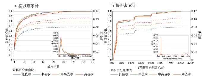
4.2.2 青藏高原人口流动联系强度空间模式 按照公式(2)计算得到了青藏高原与全国其他城市的联系强度值,并从人口流动的角度来揭示青藏高原与其他城市的交互作用的空间模式。由联系强度百分比分布曲线可知(图8a),4个季节联系强度排前6位的城市都有着高达85%的累积百分比,而累积百分比为99%时所对应城市个数在低值季—中值季—中高值季—高值季依次为24、23、24和26,并且青藏高原与全国地级市人口流动过程中,与其具备联系强度值(联系强度值大于0)的城市量仅占全国城市总量8%。在具备交互关系的城市中,成都和兰州为最重要城市(图8a右下角累积百分比曲线斜率变化的峰值为2);临夏、重庆、乌鲁木齐、绵阳为第二级别的联系强度城市。从不同季节的联系强度累积值曲线来看,低值季与中值季相对差异较小,但中高值季—高值季出现相对较高的分化现象,表明青藏高原在高值季和中高值季与外界的交互能力明显增强,反映了青藏高原点集中式人口流动空间交互模式,但随季节变化略有差异。
图8
 新窗口打开|下载原图ZIP|生成PPT
图8人口流动联系强度累积百分比和累积值曲线
Fig. 8The cumulative percentage and cumulative value curve of population interaction intensity with the number of cities (a) and with the distance to the Qinghai-Tibet Plateau (b)
图8b显示了联系强度随距离变化的累积百分比和累计值曲线。由累积百分比曲线可以看出与青藏高原区域(几何中心)距离1400 km内的城市联系强度累积百分比高达95%,表明青藏高原与全国交互的辐射范围边界大致在1400 km,并且该距离范围内联系强度的累积百分比呈现两个不同速率增长的城市带,分别是700 km内的急速增长带(累积百分比为75%)、700~1400 km的缓慢增长带(累积百分比为20%)。
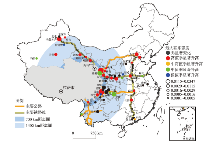
城市与青藏高原联系强度的时间变化特征分为4类(图9):季节变化不显著(黑色圆),高值季显著升高(红色圆),低值季显著升高(蓝色圆)和中值季显著升高(绿色圆),圆的大小表明其最大联系强度的取值。可知,整体上与青藏高原有人口交互联系的城市大都分布在进藏的主要公路或铁路沿线,其中公路或铁路的交通枢纽联系强度较大。兰新高铁或青藏线沿线的乌鲁木齐、兰州、临夏州、张掖、嘉峪关、酒泉、宝鸡以及滇藏线的昆明、德庆、迪庆等有明显的交互能力。从空间拓扑关系来看,呈现出从青藏高原的一阶邻近地级市(700 km内),到青藏高原的一阶临近省会级市(1400 km内)再到中东部的一、二线城市(1400 km外)递减规律。成都、兰州作为直接入藏的重要交通中转及物资输送枢纽,其联系强度最大[32,33,34,35]。重庆、西安、乌鲁木齐、昆明和太原等城市由于较完备的交通设施及相对的距离优势,联系强度次之,而北京、郑州、长沙、武汉由于各自航空、铁路或公路的重要位置和较高社会经济水平,能够与青藏高原保持着一定的人口流动的交互能力。从季节变化特征看,大部分城市表现出高值季显著增加的特征,仅有重庆、广安、临夏和德宏等6个城市表现为中值季显著增加,这与青藏高原第三产业服务人员的主要来源地基本吻合[37, 40]。而运城、眉山和吐鲁番则因为资源往来在低值季显著增加但整体联系强度较弱[40,41]。
图9
 新窗口打开|下载原图ZIP|生成PPT
图9与青藏高原存在紧密联系的主要城市人口流动时空特征
注:该图基于国家测绘地理信息局标准地图服务网站下载的审图号为GS(2016)1579号的标准地图制作,底图无修改。
Fig. 9The spatiotemporal characteristics of population mobility in major cities closely related to the Qinghai-Tibet Plateau
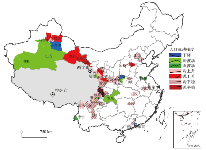
4.3 青藏高原人口流动时空模式及驱动力分析
进一步分析青藏高原与全国城市联系强度的时空变化模式及驱动因素,图10表示各城市联系强度的时空聚类结果,并将人口流动时空模式分为平稳(强平稳、弱平稳),上升(强上升、弱上升),波动(强波动、弱波动)和下降等模式。图10
 新窗口打开|下载原图ZIP|生成PPT
图10与青藏高原存在紧密联系的主要城市的人口流动强度时空变化模式
注:该图基于国家测绘地理信息局标准地图服务网站下载的审图号为GS(2016)1579号的标准地图制作,底图无修改。
Fig. 10Spatiotemporal patterns in the intensity of population mobility in major cities closely related to the Qinghai-Tibet Plateau
从空间分布看,青藏高原人口流动具有空间集群特征,与青藏高原人口交互的城市整体上呈现平稳和上升的模式,少部分城市呈现出波动,极少城市呈现下降模式。上升和平稳模式覆盖范围包括青藏高原直接邻接城市以及中东部的大中城市。由于低温条件的限制,低值季时段青藏高原地区的旅游发展受限,阻碍了人口的流动;在7—10月的旅游旺季,陕西、甘肃、四川等省份城市既是旅游的主要客源地,同时又是东部城市前往青藏高原的重要交通枢纽[32,33,34,35,36,37,38,39],这些因素显著增强了高值季青藏高原与它们的人口交互作用;中东部的北京、天津、长沙、武汉等城市(弱上升)作为经济发展水平高、交通发达区域,成为了旅游重要客源地及商务往来的主要集中地[35, 37-38, 41];广州、南京、合肥等区域呈现平稳变化模式。
在低值季呈现大范围降低的格局下,新疆吐鲁番、山西运城以及广东东莞等呈现出低值季上升后持续下降的变化模式,原因多为常年季节性的资源运输和工业产业带动(煤炭、石油、工业盐、天然气以及建筑业材料)[36]。而濒临青藏高原的周边区域,新疆巴音、和田,甘肃的临夏和四川的重庆、广安、眉山以及河南的三门峡呈现出先升后降的波动模式,主要是由于旅游产业和建筑行业带动的各种务工和第三产业的需求[39,40,41];而江苏的徐州和云南的德宏则呈现先升再降而后再升的强烈波动模式,这源于德宏、徐州地区与青藏高原在特定季节的货运往来和项目援建输入关系,导致不同季节的联系强度值出现较大的波动。
5 结论
本文利用腾讯日迁徙大数据,探讨了青藏高原与国内存在较强人口流动关系的城市之间的人口流动模式,初步探索了与青藏高原互动的主要城市及季节变化规律,并分析了人口流动季节变化的驱动因素,结论如下:由2015—2018日迁徙数据时间序列分析结果可知,青藏高原近年在人口流动量和流动网络节点重要性上呈现上升趋势,并具有显著性的周期性季节变化模式,其在全国人口流动网络中的重要性也呈现季节变化特征,均呈现低值季—中值季—中高值季—高值季递增趋势。从年际变化看,2015—2018年其人口流动量提升了8.2%,在全国城市人口流动网络中的重要性排名提升了24.5%;从季节性变化看,中值季、中高值季和高值季相对低值季而言,日均人口流动量依次增高14.2%、26.7%和57.8%。
从人口流动总量和方向来看,青藏高原的人口流动可以划分为4个大区,其中流动量主要集中在东部南北22.5°扇形区,4个季节所占人口流动量比重均值为91.0%,且人口流动数量随季节变化波动较小;而东北22.5°至北西22.5°区域内的人口流动数量随季节变化波动幅度最大。从联系强度看,目前与青藏高原存在直接交互的国内城市有41个,呈现距离导向的辐射圈层,距离青藏高原1400 km内的城市累积联系强度值达95%,并主要沿交通轴线分布,呈现点式空间格局。
目前与青藏高原有交互能力的城市中,大部分呈现出四季平稳和低值季—中值季—中高值季—高值季持续上升的变化模式,主要因素是旅游旺季的人流量带动;其周边的巴音、和田、重庆、广安、临夏和三门峡呈现先上升再下降的波动模式,在高值季来临前达到交互的峰值,反映了旅游产业所带动的劳务输出的季节性模式。而运城、吐鲁番和东莞则在低值季明显增加,揭示了其与青藏高原的物资运输的往来及变化模式。
从总体上看,青藏高原目前在全国范围内人口流动辐射影响力还较低,人口流动的驱动力因素单一且局限,旅游、商贸在增进人口流动方面仍有较大提升空间。
参考文献 原文顺序
文献年度倒序
文中引用次数倒序
被引期刊影响因子
[本文引用: 1]
[本文引用: 1]
[本文引用: 1]
[本文引用: 1]
[本文引用: 1]
[本文引用: 1]
[本文引用: 1]
[本文引用: 1]
[本文引用: 1]
[本文引用: 1]
[本文引用: 1]
[本文引用: 1]
[D].
[本文引用: 1]
[D].
[本文引用: 1]
DOI:10.18402/resci.2016.12.02URL [本文引用: 1]

With the global warming, the gradual increase in urban heat island effect, summer tourism is the most urgent needs of the summer travel. This paper currently our country summer tourism resources as the foundation, studies and discusses the spatial suitability distribution of summer tourism base construction. The research by UTCI climate comfort index and GIS spatial analysis method and AHP analytic hierarchy process(AHP)based, with GIS spatial analysis technique of multivariate data modeling processing, weighting to obtain the tourism climate comfortable degree index, in order to build the national A-level scenic spot core center, service industry around radius, to build a comprehensive a number of industrial chain elements, tourism environment comfortable, at home and abroad has an influence on the comprehensive summer tourism base. The findings are as follows. The spatial distribution of China’s summer tourism resources exhibits a double-peak characteristic, with concentrations in the mid- and high-latitude and high-altitude regions. Second, the specific spatial distribution included areas surrounding the Qinghai-Tibet Plateau and Liaodong Peninsula and coastal areas of Shandong Peninsula and the part of in southwest China. The Liaodong Peninsula and coastal areas of the Shandong Peninsula is the most ideal summer tourism destinations. The second largest concentration of suitable summer tourism destinations is found in the southwestern mountains and plateaus, with Guiyang and Kunming as the core and including their peripheral areas. Next is the northeastern mountains and plains, comprising Shenyang, Jilin and their peripheral areas. Fourth largest is the central region of the northwest, with Xining and Lanzhou as the central axis and radiating in a north-south direction.
[本文引用: 1]
[本文引用: 1]
[本文引用: 1]
[本文引用: 1]
[本文引用: 1]
[本文引用: 1]
[本文引用: 1]
[D].
[本文引用: 1]
[D].
[本文引用: 1]
[本文引用: 1]
[本文引用: 1]
[本文引用: 1]
[本文引用: 1]
[本文引用: 1]
[本文引用: 1]
[本文引用: 2]
[本文引用: 2]
[本文引用: 2]
[本文引用: 2]
[本文引用: 2]
[本文引用: 2]
[本文引用: 2]
URLPMID:28553155 [本文引用: 2]
[本文引用: 2]
[本文引用: 2]
[本文引用: 2]
[本文引用: 1]
[本文引用: 1]
[本文引用: 1]
[本文引用: 1]
[本文引用: 1]
[本文引用: 3]
[本文引用: 1]
[本文引用: 1]
[本文引用: 1]
DOI:10.1016/j.rse.2014.09.010URL [本文引用: 1]
[本文引用: 1]
[本文引用: 2]
URL [本文引用: 2]
URL [本文引用: 2]
URL [本文引用: 2]
URL [本文引用: 2]
[本文引用: 2]
[本文引用: 2]
[本文引用: 3]
[本文引用: 3]
URL [本文引用: 2]
URL [本文引用: 2]
URL [本文引用: 3]
URL [本文引用: 3]
URL [本文引用: 2]
URL [本文引用: 2]
URL [本文引用: 2]
URL [本文引用: 2]
URL [本文引用: 3]
URL [本文引用: 3]
URL [本文引用: 3]
URL [本文引用: 3]
