 ,2, 李宗盟3, 潘保田2, 苏怀4
Terraces development and their implications for valley evolution of the Jinsha River from Qiaojia to Menggu
LIU Fenliang1, GAO Hongshan,2, LI Zongmeng3, PAN Baotian2, SU Huai4通讯作者:
收稿日期:2019-11-12修回日期:2020-02-27网络出版日期:2020-05-25
| 基金资助: |
Received:2019-11-12Revised:2020-02-27Online:2020-05-25
| Fund supported: |
作者简介 About authors
刘芬良(1987-),男,博士,湖南益阳人,主要从事河流地貌研究E-mail:fenliangliu@126.com。

摘要
关键词:
Abstract
Keywords:
PDF (4796KB)元数据多维度评价相关文章导出EndNote|Ris|Bibtex收藏本文
本文引用格式
刘芬良, 高红山, 李宗盟, 潘保田, 苏怀. 金沙江巧家—蒙姑段的阶地发育与河谷地貌演化. 地理学报[J], 2020, 75(5): 1095-1105 doi:10.11821/dlxb202005015
LIU Fenliang.
1 引言
河谷的形成与发育问题是地质地貌学长期关注的经典课题,有关河谷发育的学说已经成为了地貌学发展的支持基石和理论源泉[1,2,3]。金沙江是长江的上游河段,是亚洲“辐射状”水系格局的重要组成部分,因其独特的河谷形态,从20世纪初开始就受到了地质地貌学界的广泛关注。一百多年来,包括Davis[4]在内的大量****就对金沙江水系的演化模式,特别是石鼓附近“长江第一弯”的成因进行研究,提出了不同的观点。归纳起来主要有河流袭夺说[5,6]和非袭夺说[7,8]。近年来,随着沉积物物源示踪技术和测年手段的发展,对金沙江水系演化特别是金沙江何时转向东流的研究日益丰富。如Zheng等通过对长江下游盆地中的沉积地层进行物源示踪研究,认为金沙江水系曾经南流入古红河,后来因为长江的向西袭夺才导致金沙江东流,时间不晚于23 Ma[9];Zhang等则基于河谷沉积物的物源示踪,认为现代金沙江水系格局在晚上新世才形成[10];Kong等同样支持古金沙江南流的观点,但认为金沙江转向东流的时限在早更新世(1.3~1.5 Ma)[11]。最近,对于金沙江现代河谷的形成时代的研究也取得了一系列的进展,如张叶春等和杨达源等基于河流阶地的研究认为金沙江河谷形成于早更新世(1~1.7 Ma)[12,13];Clark等基于低温热年代学研究,认为金沙江河谷下切时代为中中新世(9~13 Ma)[14];McPhillips等通过对河谷中的洞穴沉积物进行宇生核素测年,认为金沙江河谷在早中新世(18 Ma)时就已经下切了将近1 km[15];Su等则通过利用多种测年方法对金江街附近的河流阶地的年代进行了测年,并根据下切速率推测金沙江现代河谷的形成时代大约在上新世的5 Ma[16]。综上所述,对于金沙江河谷的形成时代与形式问题还存在较大争议。究其原因,除问题本身复杂外,不同****研究问题的角度和所采用的证据不同可能是其重要因素。河流阶地作为曾经的河床或河漫滩随着河流的下切而被废弃在河谷谷坡之上的阶梯状地形,是山区河谷中最为突出的地貌景观,是流域地貌演化与河谷发育历史最直接的记录者,蕴含了丰富的河谷地貌演化信息[17,18]。近年来研究团队对金沙江巧家—蒙姑段河谷中的河流阶地及相关沉积进行了详细调查,并运用GPS高程测量技术获取了一系列较为准确的高程资料,利用光释光(Optical Stimulated Luminescence, OSL)和电子自旋共振(Electron Spin Resonance, ESR)等测年手段得到了一批年代数据。基于这些数据,本文对该段河谷地貌的形成时代与发育过程进行分析,进而探讨金沙江河谷发育模式。
2 研究区概况
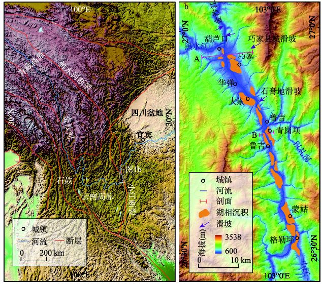
金沙江发源于青藏高原唐古拉山格拉丹东雪山,先沿青藏高原东南缘,与澜沧江、怒江并行自北向南流,行自云南石鼓附近后,突然折向北流,形成长江第一弯,之后深切于云贵高原,在三江口、涛源、攀枝花和龙街等附近历经数次急剧拐弯,最后东流在四川宜宾附近汇入长江,形成著名的“W”型深切河谷,在深切河谷之间又镶嵌有宽谷。研究区巧家至蒙姑段位于金沙江的下游(石鼓以下),为一南北走向的宽谷。巧家附近谷底宽约6 km,呈现为河谷盆地形态,为一拉分盆地[19]。而在该段河谷的上、下游,河谷束窄,呈深切峡谷形态。该段河谷谷坡陡峭,滑坡崩塌等坡面活动频繁。河谷中堆积了大量的第四纪松散沉积物,如滑坡堆积物、洪积物、堰塞湖相沉积[20],成为河谷中城镇建设和农业活动的重要场所。金沙江的两条支流小江和黑水河分别从该段河谷的南端和北端汇入金沙江。深切河谷的谷肩之上为平坦的高原面,发育了2~3级夷平面[21,22]。该区位于川滇菱形地块的东缘,则木河—小江断裂平行穿越河谷,第四纪时期遭受了强烈的构造抬升,构造活跃,地震频发。气候属亚热带半湿润气候[23],夏季主要受印度季风影响,冬季则受西风漂流南支影响,年均温21.5 °C,年均降雨量765.7 mm,,在河谷中则受山谷风和焚风作用的影响,气候炎热干燥,为典型的干热河谷气候。
3 研究方法
地貌的形成时代是长尺度地貌演化分析研究的基础与前提,本文主要采用光释光 (OSL)和电子自旋共振(ESR)方法来对河流阶地及其相关沉积进行测年。3.1 OSL样品采集和测试方法
首先清除采样点处厚约30 cm的表层物质,以避免采集到表层曝光的样品,然后将长约30 cm、直径约5 cm的厚壁不锈钢钢管的一端塞上黑色塑料袋等避光材料,从另一端将钢管用锤垂直砸入新鲜剖面中,待样品充分装满管后将管取出,用同样材料塞紧里端,并用胶带束紧两头,直到实验室分析。在室内参照Lai等描述的步骤[24],在微弱的红光条件下将采样管中段的样品取出,一部分样品用10%的HCl和20%的H2O2进行处理,去除碳酸盐类和有机质,清洗干净后用分样筛提取38~63 μm的粒组(如果该组分样品过少则筛取90~150 μm的粗颗粒组分),用35%氟硅酸(H2SiF6)浸泡1~2周除去长石,再滴入少量10%的盐酸去除样品与氟硅酸反应过程中产生的氟化物沉淀。最后,在烤箱中将样品烘干后,用磁选仪将样品中的磁性矿物去掉。所有样品的释光信号强度均在自动化的Ris? TL/OSL-DA-20仪器上进行测试。等效剂量(De)根据单片再生法(SAR)[25]和标准生长曲线法(SGC)[24]相结合的方法来确定。另一部分样品则用来测定含水量以及U、Th和K的含量,在中国原子能科学研究所完成,测量方法为中子活化法。样品的前处理和测试都在兰州大学西部环境教育部重点实验室OSL年代学实验室中完成。OSL年代结果和相关信息如表1所示。
Tab. 1
表1
表1金沙江巧家—蒙姑段河流阶地及其相关沉积的OSL年代和相关参数
Tab. 1
| 样品编号 | 海拔(m) | K(%) | Th(ppm) | U(ppm) | 含水量(%) | 剂量率(Gy/ka) | 等效剂量(Gy) | 年代(ka) | 采样部位 |
|---|---|---|---|---|---|---|---|---|---|
| QGB3 | 806 | 1.6±0.05 | 8.6±0.3 | 2.2±0.1 | 10±5 | 2.8±0.1 | 200.5±15.6 | 71±7 | 青岗坝T3 |
| QGB4 | 850 | 1.5±0.05 | 7.7±0.2 | 2.2±0.1 | 10±5 | 2.7±0.1 | 235.0±4.8 | 88±5 | 青岗坝T4 |
| QGB5 | 773 | 1.8±0.05 | 12.0±0.3 | 2.5±0.1 | 10±5 | 3.3±0.2 | 161.3±6.4 | 49±3 | 青岗坝T2 |
新窗口打开|下载CSV
3.2 ESR样品采集和测试方法
为避免样品受到污染,清除采样点处约30 cm后的表层沉积物,露出新鲜剖面,然后遮光采集样品,并将样品直接装入黑色塑料袋进行包装封存,带回实验室处理。在实验室内,将每个样品分成两份,第一份用来测定样品的剂量率,前处理方法参考Zhao等提供的步骤[26],首先在水中冲洗筛选出100~140 μm粒组,然后依次加入30%的双氧水除去杂质,在37%的盐酸中浸泡2天除去碳酸盐,用40%的氢氟酸浸泡约6 h,除去大部分长石以及石英颗粒的表层,待冲洗干净后,在40 ℃烘箱中烘干,用磁选仪去掉磁性矿物。然后,样品被分成9份,每份重约300 mg,送至北京大学放射化学院钴源实验室进行人工辐照,辐照剂量分别为0 Gy、200 Gy、400 Gy、800 Gy、1200 Gy、1600 Gy、2000 Gy、3000 Gy、4000 Gy和6000 Gy。辐照后的样品在实验室放置1个月,去除辐照后产生的不稳定型号。最后,这些样品被送至中国地震局地质研究所,在德国Bruker公司生产的EMX型ESR谱仪上进行ESR信号强度的测试,测年信号为E'心和Ge心。测试条件为:室温、X波段、中心磁场348 Mt、扫宽5 Mt、调制幅度0.1 Mt、转换时间5.12 ms、时间常数40.96 ms、微波功率2 Mw。本文选用单饱和指数方程对这些信号数据进行拟合[27],通过线性外推,即可计算得到ESR信号强度为零时的辐照剂量,即样品的总剂量。第二份样品送至核工业北京地质研究院分析测试中心用激光荧光法、比色分光光度法和原子吸收技术分别测定样品中的U、Th和K的质量分数,含水量的测定则在兰州大学前处理实验室完成,然后根据样品中的U、Th、K和水的含量,计算得到样品的年剂量。利用公式T = TD/d计算得到每个样品的ESR年代,其中T为样品年代,TD为样品的总剂量,d为样品的年剂量。样品的ESR年代结果和相关信息如表2所示。
Tab. 2
表2
表2金沙江巧家—蒙姑段河流阶地及其相关沉积的ESR年代和相关参数
Tab. 2
| 样品编号 | 海拔(m) | U(μg/g) | Th(μg/g) | K2O(%) | 含水量(%) | 剂量率(Gy/ka) | 古剂量(Gy) | 年代(ka) | 采样部位 |
|---|---|---|---|---|---|---|---|---|---|
| HLK-1 | 647 | 1.17 | 4.77 | 0.86 | 0.34 | 1.65 | 94.1±8.6 | 57±5 | 葫芦口T1 |
| HLK-2 | 775 | 2.00 | 8.56 | 2.10 | 3.30 | 3.18 | 1731±260 | 544±82 | 葫芦口T2 |
| HLK-3 | 810 | 1.63 | 6.74 | 1.52 | 5.88 | 2.37 | 1934±113.8 | 816±48 | 葫芦口T3 |
| HLK-4 | 900 | 2.00 | 8.56 | 2.10 | 3.30 | 3.18 | 2957±294.8 | 930±92 | 葫芦口T4 |
| HLK-5 | 958 | 2.22 | 10.3 | 2.43 | 4.31 | 3.61 | 3896±679.9 | 1079±188 | 葫芦口T5 |
| HLK-6 | 1015 | 2.17 | 11.4 | 2.02 | 4.77 | 3.29 | 3914±507.0 | 1190±154 | 葫芦口T6 |
| QGB-1 | 685 | 1.59 | 7.44 | 1.14 | 0.50 | 2.20 | 58.2±11.1 | 26±5 | 青岗坝T1 |
| QGB-2 | 688 | 1.75 | 7.01 | 1.52 | 1.38 | 2.54 | 52.3±1.7 | 20±6 | 青岗坝T1 |
| QGB-6 | 920 | 2.13 | 8.44 | 1.86 | 2.74 | 3.01 | 1893±405.7 | 629±134 | 青岗坝T5 |
新窗口打开|下载CSV
4 河流阶地的空间展布与形成时代
在金沙江巧家—蒙姑段河谷内,河流沉积与古堰塞湖沉积、冲洪积物等相互堆叠,交错分布,河流阶地的发育和保存很差,特别是高级河流阶地缺乏,空间分布不连续,很难进行上、下游对比。此外,阶地的类型十分复杂,除了河流阶地,堰塞湖阶地和洪积阶地广泛分布。本文仅对主要考察地点有年代学数据支撑的葫芦口和青岗坝附近的阶地序列进行报道。葫芦口断面(图1b断面A)。在葫芦口附近,剥蚀面之下金沙江共发育和保存了8级河流阶地(图2),都为基座阶地,主要分布在金沙江与黑水河交汇处的武圣宫梁子上。其中,T8分布在武圣宫梁子顶上,阶地面较宽,砾石层拔河高度为469 m,砾石层厚约2 m,磨圆度较好,砾石与粘土混杂,沙粒含量较少,可能是后期风化作用的结果,由于本次采集的样品中没有得到足量的石英,未获得准确的年代;T7也分布在武圣宫梁子上,阶地面较宽,砾石层拔河高度为435 m,砾石层厚约1.5 m,磨圆度较好,由于风化严重,砾石与粘土混杂,沙粒含量较少,采集的样品同样未得到足量的石英,未获得准确年代;T6主要分布在武圣宫梁子两侧,阶地面较窄,砾石层顶的拔河高度为385 m,砾石层厚约3 m,胶结严重,沙粒含量较少,砾石层顶部的ESR测年为1190±154 ka,代表河流的下切时代;T5分布在武圣宫梁子上,砾石层拔河高度约为328 m,砾石厚约为4 m,砾石磨圆度高,采样位置位于砾石层上部,ESR测年结果为1079±118 ka,代表河流的下切时代;T4分布在武圣宫梁子上,砾石层拔河高度约270 m,砾石层厚约10 m,砾石层底部ESR测年结果为942±92 ka,为砾石层的堆积时代;T3的阶地面非常宽广,砾石层拔河高度约为180 m,砾石层厚约3 m,磨圆度好,岩性复杂,砾石层顶部为由粉砂和黏土所组成的湖相沉积地层,砾石层底部ESR的测年结果为816±48 ka,为砾石层的堆积时代;T2的阶地面较窄,砾石层拔河高度约为120 m,砾石层厚约5 m,砾石磨圆度好,砾石层底部的ESR测年结果为544±82 ka,为砾石层的堆积时代;T1为宽谷型阶地,砾石层拔河高度17 m,砾石层厚1.5 m,砾石层顶部ESR测年结果为41±5 ka,为河流的下切时代。
图1
 新窗口打开|下载原图ZIP|生成PPT
图1研究区概况
Fig. 1Schematic map showing the location and topography of the study area
图2
 新窗口打开|下载原图ZIP|生成PPT
图2葫芦口附近的河流阶地断面及其相关沉积测年
Fig. 2Cross section of the Jinsha River valley near the Hulukou
区域内在较低级阶地上零星地保存了少量的湖相沉积。在葫芦口对岸的巧家县城附近广泛分布了堰塞湖相沉积,可能是由于葫芦口附近的地形较为陡峭,不利于堰塞湖相沉积的堆积和保存,而巧家地区由于位于一大型滑坡体上,地形平缓开阔,可以湖湘沉积的堆积和保存提供广阔空间。
青岗坝断面(图1b断面B)。在青岗坝村附近,金沙江河谷谷坡上发育和保存了5级阶地(图3),阶地面向河微倾,从高到低,阶地面的平均拔河高度分别为278 m(T5)、190 m(T4)、130 m(T3)、90 m(T2)和30 m(T1)。从野外露头来看,这些阶地的组成物质以灰黑色或灰色的粗砂—粉砂为主,在河心一侧,粒径较小,在靠谷坡一侧,粒径较粗,且常含有棱角状的巨型砾石。该套沉积的厚度巨大,结构较为松散,水平层理十分明显。从沉积相分析,这套沉积应为快速过水湖相沉积,即堰塞湖相沉积,这些阶地则为堆积型阶地,亦可称之为堰塞湖阶地。其中,第5级阶地的湖相沉积直接上覆于洪积物之上,并向山坡方向逐渐尖灭,阶地面后缘海拔为926 m,湖相沉积顶部的ESR测年结果为629±134 ka,可以大致代表这级阶地的形成时代;第4级阶地的湖相沉积也直接覆盖在洪积物之上,湖相沉积顶部的OSL年代结果分别为88±5 ka;第3级阶地的湖相沉积未见底,湖相沉积露头厚约30 m,顶部的OSL测年结果为71±7 ka;第2级阶地的湖相沉积覆盖在河流砾石层之上,砾石层磨圆度高,但胶结特别严重,应为过去金沙江的河床砾石,湖相沉积顶部的OSL测试结果为49±3 ka;第1级阶地广泛分布在河谷两侧,阶地面非常宽广,向上游和下游延伸,在青岗坝对岸的鲁吉表现为非常宽广的平台,在青岗坝附近,湖相沉积直接覆盖在基岩上,在鲁吉附近,湖相沉积之下下伏一套磨圆非常好的河床砾石,上部则上覆一套河流砾石沉积,ESR测年结果显示,湖相沉积的形成年代为20±6 ka,下伏砾石层的形成年代为26±5 ka。
图3
 新窗口打开|下载原图ZIP|生成PPT
图3青岗坝附近的河流阶地断面及其相关沉积测年
Fig. 3Cross section of the Jinsha River valley near the Qinggangba
5 讨论
5.1 金沙江现代河谷的形成时代
目前,学术界对于金沙江现代河谷的形成时代还存在较大争议。河流阶地是河谷形成演化忠实的记录者,特别是最高级阶地往往可以指示河谷出现的时代。另外,古堰塞湖沉积也是在河谷下切过程中滑坡堵塞河谷后形成的静水沉积,同样可以指示现代河谷出现。最近,大量基于沉积盆地沉积物物源示踪的研究表明,该区金沙江水系格局的形成可以追溯到中新世[9, 28],但上新世夷平面的广泛分布表明水系在上新世末重新进行了组织,现代河谷即是在高原强烈隆升的背景下,水系从夷平面上重新下蚀而形成的,之前的古水系随着高原的隆升和夷平面的解体而消亡。本文通过对金沙江巧家—蒙姑段河谷中河流阶地和古堰塞湖相沉积的研究可知,在巧家—蒙姑段金沙江在约1.2 Ma时才从夷平面上下切至海拔1100 m左右的位置。如果按当时的下切速率外推,可以计算得到葫芦口剖面T7和T8的形成时代分别为1.28 Ma和1.37 Ma,代表该段河谷在约1.4 Ma前就已经出现。而到0.63 Ma时,古堰塞湖沉积的大量出现则代表了深切河谷地貌的形成。此外,大量****还对金沙江河谷中的河流阶地和相关沉积的年代进行了研究,如张叶春等测得金沙江石鼓以上的河流阶地阶地形成于1.54 Ma,而石鼓至宜宾段河谷中的河流阶地形成于1.78 Ma [12],Su等在金江街段测得最高级阶地的形成时代为1.02 Ma[16],杨达源等通过对永善—宜宾段河谷地貌进行研究并测得高级河流阶地上沉积物的形成时代介于1.17—1.02 Ma之间[13],Kong等测得攀枝花段河谷中以昔格达组为代表的湖相沉积物的形成时代介于1.3—1.5 Ma之间[10],以上这些研究共同指示了金沙江下游段现代河谷出现的时代不晚于早更新世晚期。5.2 河流阶地对气候变化的响应
河流阶地是随着河流的下切目前已经被废弃的古河床或河漫滩[29],其形成受控于不同时空尺度上外因如构造抬升、气候、基准面(海平面或局部基准面)变化[17, 30-32]或内部因子即河流系统内在动力的变化[33]。目前,在轨道尺度(地貌尺度)上,构造运动和气候变化共同作用驱动阶地的形成已经逐渐成为学界的共识,即区域的构造隆升为河流的下切提供了垂直空间,气候变化则通过流域降水、植被覆盖度等变化影响河流的径流和泥沙量,从而控制河流的侵蚀与堆积过程[34]。大量全球性的对比研究表明,无论是冰期—间冰期或间冰期—冰期,都可以通过气候转型期的流域水文状况的变化,引起河流的下切,从而形成阶地[18]。在亚轨道或更小尺度上,大量研究同样表明河流的侵蚀下切主要发生在气候转型期[35,36,37]。通过对比来自鹤庆盆地印度季风指数和全球的气候变化资料等[38,39](图4),发现葫芦口附近发育的6级基座阶地的形成时代能较好地对应全球和区域的气候变化,其中,T6、T5、T1砾石层顶部年代分别对应于MIS 35/36、33/34、3/4,同样也位于印度季风的转型期,由于阶地砾石层顶部的年代大致可以代表河流的下切时代,说明河流的下切恰好位于气候从冷到暖的转型期;T4、T3、T2砾石层的堆积时代分别对应于MIS 24、20、14,即河流的堆积都位于气候的冷期,因此,可以推断河流的下切大致位于气候的冷暖转变期,分别为MIS 23/24、19/20、13/14。虽然测年结果的误差可能会使得上述结论存在一定的不确定性,需要佐以其他沉积物学证据,但相关研究发现这一现象在金沙江的支流雅砻江下游段也同样存在[40],说明在该区域河流阶地是河流系统对区域或全球气候变化响应的产物,流域水沙条件的改变是导致河流加积/下切作用的主要因素。
图4
 新窗口打开|下载原图ZIP|生成PPT
图4巧家至蒙姑段河流阶地序列与区域和全球气候对比。
注:深海氧同位素曲线引自Lisiecki等[38];ISM index(印度季风指数)曲线引自An等[39]。
Fig. 4Comparison of aggradation and incision phases in the Jinsha River valley near the Hulukou with global marine oxygen isotope climate record (Lisiecki and Raymo, 2005) and ISM index (An et al., 2011)
5.3 河谷发育过程与模式
河谷的形态与发育过程密切相关,如宽广河流阶地的存在指示了河流在下蚀过程中经历均夷阶段,即在相当长的时期内,河流可以保持在一个比较稳定的高度,以侧蚀拓宽河谷为主,而后再次深切侵蚀使原有的河床或漫滩脱离河流作用成为阶地[34]。河谷中发育完好的河流阶地序列表明下切和均夷交替进行,河谷的形成以“下切—均夷—下切—均夷”模式为主,如兰州段黄河河谷[41]。但金沙江河谷中整体而言,河流阶地十分稀少且不连续,阶地面较为狭窄,说明自早更新世从夷平面上下切以来,河流以强烈下切为主,能达到均夷的阶段较为短暂。另外,该段河谷中开始堆积大量的湖相沉积,这是陡坡滑坡堵江堰塞的结果。研究发现,0.63 Ma以来该段河谷至少发生了5期大型滑坡堵江事件。目前在该段河谷以及下游河谷中仍可见多处明显的滑坡地形和残余的堰塞坝体[42,43],如巧家县城大滑坡、石膏地滑坡等,历史时期发生的几次滑坡堵江事件甚至有详细的史料记载[44],表明该段河谷中滑坡堵江事件十分频繁。滑坡和堰塞作为一种灾变的地表过程,深刻影响着河流地貌的变化[45,46]。原先由于构造运动而强烈下切的金沙江河谷受到了滑坡堰塞事件的扰动,在坝体上游发生强烈堆积,河谷的发育过程也因此发生变化,从原先以下切为主的模式转变成以“下切—滑坡—堰塞—堆积—下切”过程为主(图5)。每次滑坡堵江都造成坝体上游堰塞成湖,水动力环境的减弱导致上游发生强烈加积,沉积厚层的堰塞湖相沉积,后来坝体被切穿,金沙江从堰塞湖相沉积上重新下切,或许重新达到均夷发育阶地,但之后又被滑坡堵塞,使得河谷再次发生强烈堆积,如此反复,形成了复杂的河谷发育过程。就目前获取的数据而言,还无法精确反演该段河谷的下切与堆积过程,需要进一步完善年代资料。
图5
 新窗口打开|下载原图ZIP|生成PPT
图5巧家至蒙姑段金沙江河谷的发育形式
Fig. 5The model of the Jinsha River valley evolution from Qiaojia to Menggu
从基于河流阶地砾石层的拔河高度和其形成时代计算得到河流的下切速率(图4c)可以看出,1.2 Ma以来,河流的下切速率大致可以分为两段,即在约0.82 Ma以前,河流的下切速率约为0.56 mm/a,0.82 Ma之后,河流下切速率显著减缓,为0.19 mm/a。减缓的原因可能是滑坡和堰塞湖的频繁发生。随着河流的强烈下切,深切河谷出现,为滑坡的发生创造了条件。0.82 Ma以来,该段河谷中频繁发生的滑坡导致大量沉积物进入河谷,改变了河流局部的水沙关系,致使河谷强烈堆积,特别是滑坡堆积体导致在坝体上游形成堰塞湖,进而在河谷中沉积大量的湖相沉积。这些沉积物覆盖基岩河床,可以阻滞和减缓河流继续下切河床,并抑制河流向上游的溯源侵蚀。0.82—0.63 Ma之间河流速率减缓但没有发现堰塞湖相沉积的原因可能是更老的湖相沉积或被侵蚀,或被埋藏。
6 结论
通过对金沙江巧家—蒙姑段河流阶地及相关沉积的调查研究,结合OSL和ESR测年方法,确定金沙江巧家—蒙姑段河谷中,葫芦口附近发育和保存了8级河流阶地,都为基座阶地,其中,T6~T1的形成时代分别为1190 ka、1079 ka、942 ka、816 ka、544 ka和57 ka,对应于气候的冷暖转变期,指示了区域气候变化控制了河流的侧蚀堆积和下蚀行为;青岗坝附近共发育了5级由堰塞湖相沉积组成的堆积型阶地,形成时代分别为629 ka、88 ka、71 ka、49 ka和20 ka,指示了该段河谷在更新时以来至少发生了五次滑坡堵江堰塞事件,导致了河谷的强烈加积,是对区域强烈构造抬升的响应,河谷的发育模式以反复的“下切—滑坡—堰塞—堆积—下切”过程为主。河流下切速率显示,0.82 Ma之前河流平均下切速率为0.56 mm/a,之后河流的下切变为0.19 mm/a,下切速率的减缓可能是频繁滑坡堵江堰塞事件抑滞了河流下切的结果。综合流域内河流阶地及相关沉积的研究结果表明,金沙江下游段现代河谷的形成时代不晚于早更新世。参考文献 原文顺序
文献年度倒序
文中引用次数倒序
被引期刊影响因子
DOI:10.2307/1774538URL [本文引用: 1]
DOI:10.1086/623053URL [本文引用: 1]
[本文引用: 1]
DOI:10.2307/207673URL [本文引用: 1]
DOI:10.1111/j.1755-6724.1934.mp13001006.xURL [本文引用: 1]
[本文引用: 1]
[本文引用: 1]
DOI:10.11821/xb195902003URL [本文引用: 1]
DOI:10.11821/xb195902003URL [本文引用: 1]
DOI:10.11821/xb196302001URL [本文引用: 1]

Above Shi-Ku in Li-Chiang Shien, Yunnan, the upper Yangtze or Ching-Sha-Chiang flows from northwest to south-east, but near-by Shi-Ku, it gives an abrupt turn to north-east forming an horse-shoe curve which has been known as "the first curve of the Yang-tze". This curious curve has long since caught the attention of Chinese and foreign geographers and geologists who explained it in various ways. Most scholars, such as V. K. Ting, C. Y. Lee, J. W. Gregory, W. Credner, G. B. Barbour, Li Shi-thing, Lin Wen-ing, P. Misch, r. II. roptuKOS, Jen Mei-ngo, believed that this phenomenon is the result of river-capture;while others, such as Li Chen-san, Yuan Fu-li considered it as the result of geologic structure or entrenching meander. In 1962, the present writers spent two months in surveying this region and have arrived at the conclusion that the theory of river-capture is based on insufficient evi-dences. First, the great curve near-by Shi-Ku is formed by geologic structure. Secondla. the broad valley between the villages Hung-Wen-Chen and Chien-Chuan, which is more than 50 Km. in width, develops along the great fault directing NNE-SSW. In the northern part of this broad valley, there are four large depressions developed by- solu-tion, and in the middle part of it, there arc Chiu Ho basin and Ho-Tung Valley, filled with Tertiary red beds, and its southern part is occupied by the Chien-Chuan basin. In old Tertiary time both sections of the Ching-Sha-Chiang above Shi-Ku, in Te-La of Te- Chin Shien, and below Shi-Ku in Shi-Tu-Kang of Li-Chiang-Shien, were occupied by small basins filled with local deposits of red beds. Thus, it is clear that at that time China-Sha-Chiang had not yet been integrated into an unified river-system. During the Himalaya Movement between old and new Tertiary, this region was raised, and at the same time, these formerly separated basins have been gradually linked together to be a single river-system. The old Ching-Sha-Chiang was thus formed. During this move-ment, part of the region south of Chien-Chuan was sunk by block fault and became basins filled with new Tertiary deposits, such as Ta-Li basin, Er-Yuan basin, Lien-Ti-Kai basin etc., all of which consist of late Tertiary lake deposits with brown coal. At the end of Tertiary, this region had been denudated to a peneplain, but afterwards it rose again in a large scale and becomes Yunnan plateau to-day. During the uprising, Ching- Sha-Chiang cut downward and became a great canyon. Above and below Shi-Ku, the shapes and breadths of Ching-Sha-Chiang valleys are very similar to each other. Even in the narrow Hu-Tiao-Canyon, rock-shoulders are found comparable to those of the upper valley about 2500 m. in height. This fact alone is sufficient to prove that this part of Ching-Sha-Chiang valley is very old and had been linked up long ago.
DOI:10.11821/xb196302001URL [本文引用: 1]
Above Shi-Ku in Li-Chiang Shien, Yunnan, the upper Yangtze or Ching-Sha-Chiang flows from northwest to south-east, but near-by Shi-Ku, it gives an abrupt turn to north-east forming an horse-shoe curve which has been known as "the first curve of the Yang-tze". This curious curve has long since caught the attention of Chinese and foreign geographers and geologists who explained it in various ways. Most scholars, such as V. K. Ting, C. Y. Lee, J. W. Gregory, W. Credner, G. B. Barbour, Li Shi-thing, Lin Wen-ing, P. Misch, r. II. roptuKOS, Jen Mei-ngo, believed that this phenomenon is the result of river-capture;while others, such as Li Chen-san, Yuan Fu-li considered it as the result of geologic structure or entrenching meander. In 1962, the present writers spent two months in surveying this region and have arrived at the conclusion that the theory of river-capture is based on insufficient evi-dences. First, the great curve near-by Shi-Ku is formed by geologic structure. Secondla. the broad valley between the villages Hung-Wen-Chen and Chien-Chuan, which is more than 50 Km. in width, develops along the great fault directing NNE-SSW. In the northern part of this broad valley, there are four large depressions developed by- solu-tion, and in the middle part of it, there arc Chiu Ho basin and Ho-Tung Valley, filled with Tertiary red beds, and its southern part is occupied by the Chien-Chuan basin. In old Tertiary time both sections of the Ching-Sha-Chiang above Shi-Ku, in Te-La of Te- Chin Shien, and below Shi-Ku in Shi-Tu-Kang of Li-Chiang-Shien, were occupied by small basins filled with local deposits of red beds. Thus, it is clear that at that time China-Sha-Chiang had not yet been integrated into an unified river-system. During the Himalaya Movement between old and new Tertiary, this region was raised, and at the same time, these formerly separated basins have been gradually linked together to be a single river-system. The old Ching-Sha-Chiang was thus formed. During this move-ment, part of the region south of Chien-Chuan was sunk by block fault and became basins filled with new Tertiary deposits, such as Ta-Li basin, Er-Yuan basin, Lien-Ti-Kai basin etc., all of which consist of late Tertiary lake deposits with brown coal. At the end of Tertiary, this region had been denudated to a peneplain, but afterwards it rose again in a large scale and becomes Yunnan plateau to-day. During the uprising, Ching- Sha-Chiang cut downward and became a great canyon. Above and below Shi-Ku, the shapes and breadths of Ching-Sha-Chiang valleys are very similar to each other. Even in the narrow Hu-Tiao-Canyon, rock-shoulders are found comparable to those of the upper valley about 2500 m. in height. This fact alone is sufficient to prove that this part of Ching-Sha-Chiang valley is very old and had been linked up long ago.
[本文引用: 2]
DOI:10.1016/j.epsl.2008.12.003URL [本文引用: 2]
DOI:10.1002/2017GL073185URL [本文引用: 1]
[本文引用: 2]
[本文引用: 2]
URL [本文引用: 2]
Our field investigation on the Jinshajiang River section between Shigu and Yibin in recent years have discovered an ancient river valley close to Qiaojia in Yunnan Province.Some "high terraces" along the section of Jinshajiang River between Yongshang County,Yunnan Province to Yibin City,Sichuan Province are also found.The sediment components of these "high terraces" are considerably uniform but obviously differ from each other.Dating results of sediments from the"high terraces" show that the section of Jinshajiang River between Yongshan County of Yunnan Province and Yibin City of Sichuan Province was formed by river capture 1.03Ma ago,that between Wudongde Gorge in Luquan and Jinpingzi was also formed by river capture 0.8Ma ago.The Hutiaoxia Gorge was formed and captured the ancient Zhongdianhe River 0.98Ma ago.Extensive incision of the Jinshajiang River has taken place since its formation.An average incision rate of 25~30cm/ka is estimated,and the incision rate increases up to 99~77cm/ka in the past 100ka.
DOI:10.1130/G21265.1URL [本文引用: 1]
DOI:10.1002/grl.v43.1URL [本文引用: 1]
DOI:10.1016/j.gloplacha.2019.103002URL [本文引用: 2]
DOI:10.1016/0169-555X(90)90011-EURL [本文引用: 2]
[本文引用: 2]
[本文引用: 1]
[本文引用: 1]
[本文引用: 1]
[本文引用: 1]
DOI:10.1007/s11707-018-0707-yURL [本文引用: 1]
[本文引用: 1]
[本文引用: 1]
[本文引用: 1]
[本文引用: 1]
DOI:10.1191/0959683606hol980rrURL [本文引用: 2]
DOI:10.1016/S1350-4487(99)00253-XURL [本文引用: 1]
DOI:10.1016/j.quaint.2005.05.013URL [本文引用: 1]
[本文引用: 1]
[本文引用: 1]
[本文引用: 1]
DOI:10.1002/(ISSN)1099-1417URL [本文引用: 1]
DOI:10.1086/648221URL
DOI:10.1016/0277-3791(95)00043-OURL [本文引用: 1]
[本文引用: 1]
[本文引用: 2]
[本文引用: 1]
DOI:10.1016/0031-0182(94)90019-1URL [本文引用: 1]
DOI:10.1016/S0013-7952(96)00017-8URL [本文引用: 1]
[本文引用: 2]
DOI:10.1126/science.1203752URL [本文引用: 2]
The modern Indian summer monsoon (ISM) is characterized by exceptionally strong interhemispheric transport, indicating the importance of both Northern and Southern Hemisphere processes driving monsoon variability. Here, we present a high-resolution continental record from southwestern China that demonstrates the importance of interhemispheric forcing in driving ISM variability at the glacial-interglacial time scale as well. Interglacial ISM maxima are dominated by an enhanced Indian low associated with global ice volume minima. In contrast, the glacial ISM reaches a minimum, and actually begins to increase, before global ice volume reaches a maximum. We attribute this early strengthening to an increased cross-equatorial pressure gradient derived from Southern Hemisphere high-latitude cooling. This mechanism explains much of the nonorbital scale variance in the Pleistocene ISM record.
[本文引用: 1]
[本文引用: 1]
DOI:10.1186/2196-4092-1-1URL [本文引用: 1]
[本文引用: 1]
[本文引用: 1]
[本文引用: 1]
[本文引用: 1]
[本文引用: 1]
DOI:10.1038/nature07322URL [本文引用: 1]
