沈彦俊2,,,
武兰珍3,
郭英2,
陈晓璐2, 4
1.河北师范大学资源与环境科学学院 石家庄 050024
2.中国科学院遗传与发育生物学研究所农业资源研究中心 石家庄 050022
3.甘肃农业大学水利水电工程学院 兰州 730070
4.青海师范大学地理科学学院 西宁 810008
基金项目:国家自然科学基金重大专项(42041007-02)和中国科学院国际伙伴计划“一带一路”专项项目(153E13KYSB20170010)资助
详细信息
作者简介:韩春雷, 主要从事农业遥感方面研究。E-mail: 952935651@qq.com
通讯作者:沈彦俊, 主要从事农业水文与水资源研究。E-mail: yj.shen@gmail.com
中图分类号:TP79计量
文章访问数:84
HTML全文浏览量:16
PDF下载量:25
被引次数:0
出版历程
收稿日期:2021-03-05
录用日期:2021-08-09
网络出版日期:2021-09-08
刊出日期:2021-11-10
Spatial and temporal variation characteristics of cultivated land in the upper Yellow River from 2002 to 2018 based on time series MODIS
HAN Chunlei1, 2,,SHEN Yanjun2,,,
WU Lanzhen3,
GUO Ying2,
CHEN Xiaolu2, 4
1. College of Resources and Environmental Sciences, Hebei Normal University, Shijiazhuang 050024, China
2. Center for Agricultural Resources Research, Institute of Genetics and Developmental Biology, Chinese Academy of Sciences, Shijiazhuang 050022, China
3. College of Water Conservancy and Hydropower Engineering, Gansu Agricultural University, Lanzhou 730070, China
4. College of Geosciences, Qinghai Normal University, Xining 810008, China
Funds:This study was supported by the National Natural Science Foundation of China (42041007-02) and the One Belt One Road Special Project of the International Partnership Program of Chinese Academy of Sciences (153E13KYSB20170010)
More Information
Corresponding author:E-mail: yj.shen@gmail.com
摘要
HTML全文
图
参考文献
相关文章
施引文献
资源附件
访问统计
摘要
摘要:黄河上游贡献全流域水资源的56.77%, 而上游农业用水占全流域40%以上, 监测黄河上游耕地的分布对于定量评估农业用水变化至关重要。本文以黄河上游龙羊峡至河口镇流域范围为对象, 基于MOD13Q1数据集, 使用时间序列谐波分析法(Harmonic Analysis of Time Series, HANTS)对NDVI时间序列曲线进行平滑, 再结合作物生育期等物候信息与决策树分类方法提取了研究区2002—2018年的耕地分布与变化情况, 为研究上游耕地变化对流域水资源消耗的影响提供基础数据。用野外实地考察获取的地面真实样点数据与研究区内县级统计数据对提取结果进行验证, 耕地提取精度在75%以上, R2达0.85。本研究主要结果显示: 2002—2018年耕地面积总体呈增加状态, 共增加88.21万hm2; 宁蒙灌区的耕地增长最为迅速, 宁夏段耕地总面积增加64%, 2018年达76.61万hm2; 内蒙古段的耕地面积也大幅增加, 达44.74万hm2, 占总面积的44%; 甘肃段面积同样增加18.89万hm2; 青海段则显示出明显的耕地减少趋势, 共减少5.36万hm2。黄河上游整体上耕地面积增加速率为5.18万hm2·a?1, 其中青海段以0.20万hm2·a?1的速率减少, 甘肃段增加速率为1.05万hm2·a?1, 宁夏段增加速率为1.87万hm2·a?1, 内蒙段增加速率为2.46万hm2·a?1。通过定性与定量方法对耕地变化因素进行分析, 水资源政策和地方社会经济环境变化是研究区耕地面积变化的主要驱动因素。
关键词:黄河上游/
耕地面积变化/
MODIS/
NDVI/
时序分析
Abstract:The upper reaches of the Yellow River contribute 56.77% of the water resources in the whole basin, while agricultural water in the upper reaches accounts for more than 40% of the whole basin. Using MODIS data with medium-resolution remote sensing and crop phenology data, the cultivated land area in the upper reaches of the Yellow River from 2002 to 2018 was extracted, which provided basic data for studying the impact of cultivated land change in the upper reaches on water resource consumption in the basin. Using Harmonic Analysis of Time Series (HANTS) to smooth the cut and spliced MOD13Q1 data, the NDVI time series curve was easier to identify. Combined with the decision tree classification method and crop growth period and other phenological information, the decision tree rules were compiled, and then the smooth MOD13Q1 data were classified by using the classification rules. The distribution and change of cultivated land in the study area from 2002 to 2018 are obtained. Then, the confusion matrix verification of the extraction results was carried out by using the real ground sample data obtained from field investigation and the county-level statistical data in the study area. The extraction accuracy of cultivated land was above 75%, and R2 reached 0.85. The main results showed that the cultivated land in the study area were increased from 2002 to 2018, with a total increase of 88.21×10⁴ hm2. The most rapidly increased was Ningmeng Irrigation District, the total area of cultivated land in Ningxia increased by 64%, reaching 76.61×10⁴ hm2 in 2018; and Inner Mongolia increased reaching 44.74×10⁴ hm2, accounting for 44% of the total area; and Gansu section increased reaching 18.89×10⁴ hm2; Qinghai section showed an obvious trend of decrease in cultivated land, a total of 5.36×10⁴ hm2. On the whole, the increase rate of cultivated land area is 5.18×10⁴ hm2·a?1, in which the Qinghai section decreases at a rate of 0.2×10⁴ hm2·a?1, the Gansu section increases at a rate of 1.05×10⁴ hm2·a?1, the Ningxia section increases at a rate of 1.87×10⁴ hm2·a?1, and the Inner Mongolia section increases at a rate of 2.46×10⁴ hm2·a?1. Mann-Kendall analysis method was used to analyze the trend of NDVI change in the study area, and it was found that NDVI showed an increasing trend. In addition, compared with the change of precipitation, it also showed an increasing trend. Then using stepwise regression analysis to analyze the selected main indicators, the residents’ disposable income was the main factor affecting the change of cultivated land. Finally, using the collected data for qualitative analysis, it was concluded that water resources policy and engineering facilities construction are the factors affecting the change of cultivated land. The main conclusions of this paper were as follows. The cultivated land in the basin from Longyangxia to Hekou Town in the upper reaches of the Yellow River shows an increasing trend. The medium-resolution MODIS data can be used to extract the cultivated land in the upper reaches of the Yellow River. Water resources policy and local socio-economic environment change were the main driving factors for the change of cultivated land area in the study area.
Key words:Upper Reaches of Yellow River/
Change of cultivated land/
MODIS/
NDVI/
Time series analysis
HTML全文

图1黄河上游龙羊峡至河口镇地理位置及其4个区段的划分
Figure1.Location of Longyangxia to Hekou Town in the upper reaches of the Yellow River and the division of its four sections
 下载: 全尺寸图片幻灯片
图2研究区耕地作物平滑前后NDVI曲线对比
Figure2.Comparison of cultivated land NDVI curves before and after smoothing in the study area
下载: 全尺寸图片幻灯片
图3耕地曲线特征决策树分类规则
NDVI为?32 768时, 为影像背景值; 将水体、裸地等NDVI值相对较低的地物归为“其他1”, 而林地等NDVI值相对较高的地物归为“其他2”。?32 768 NDVI is the background value of image. Classification of objects with relatively low NDVI values such as water and bare land are as ‘Other 1’. Classification of objects with relatively high NDVI values such as forest land are classified as ‘Other 2’.
Figure3.Classification rules of cultivated land curve feature decision tree
下载: 全尺寸图片幻灯片
图4研究区不同年份耕地提取空间分布
Figure4.Spatial distribution of cultivated land extraction in different years in the study area
下载: 全尺寸图片幻灯片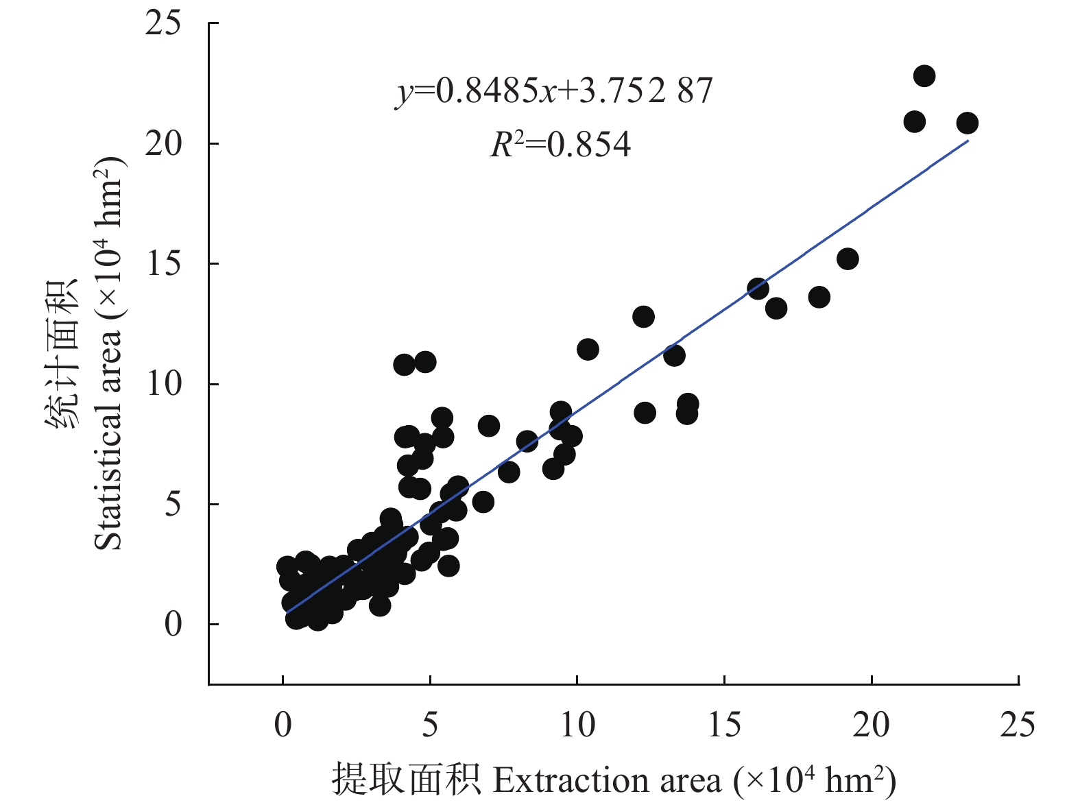
图52002—2018年黄河流域上游县级统计数据与遥感提取的耕地面积对比
Figure5.Comparison of cultivated land area based county-level statistical data and extracted by remote sensing in the upper reaches of the Yellow River Basin from 2002 to 2018
下载: 全尺寸图片幻灯片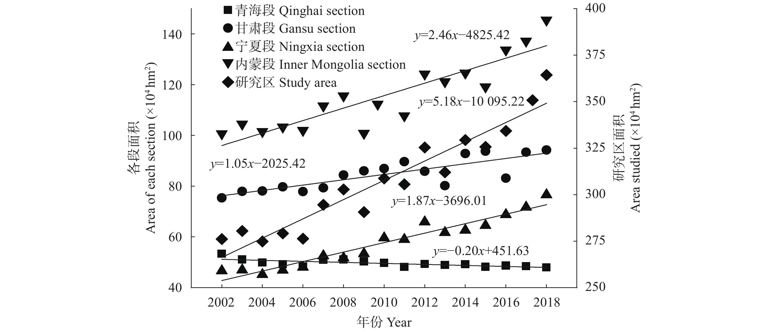
图62002—2018年黄河上游及各地区耕地面积
Figure6.Cultivated land areas of the study area and its’ different regions from 2002 to 2018
下载: 全尺寸图片幻灯片
图72002—2018年研究区耕地面积变化情况
Figure7.Changes of cultivated land area in the study area from 2002 to 2018
下载: 全尺寸图片幻灯片
图82002—2018年研究区降水量分布情况
Figure8.Distribution of precipitation in the study area from 2002 to 2018
下载: 全尺寸图片幻灯片
图92002—2018年研究区NDVI变化趋势
Figure9.Trend of NDVI in the study area from 2002 to 2018
下载: 全尺寸图片幻灯片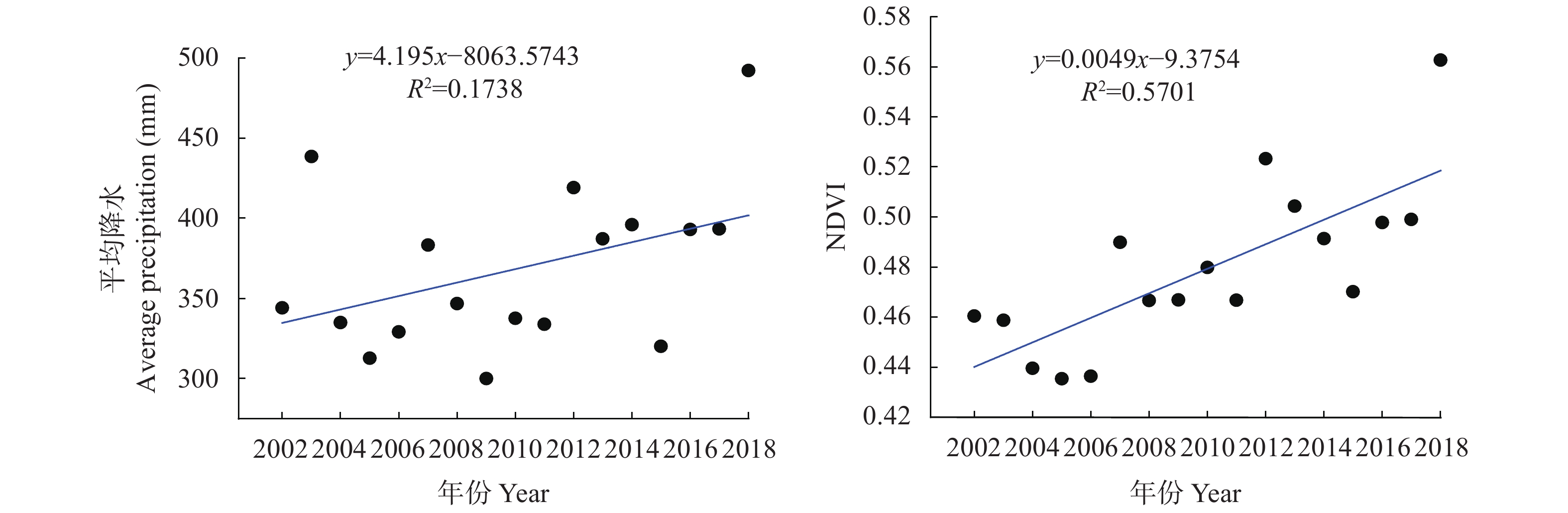
图102002—2018年研究区平均降水量和NDVI平均值变化
Figure10.Changes of average precipitation and NDVI in the study area from 2002 to 2018
下载: 全尺寸图片幻灯片
图112002—2018年甘肃、宁夏南部地区年平均降水和NDVI平均值
Figure11.Annual average precipitation and NDVI in southern regions of Gansu and Ningxia from 2002 to 2018
下载: 全尺寸图片幻灯片表1研究数据来源
Table1.Research data sources
| 数据类型 Data type | 数据来源 Data sources |
| 遥感数据 Remote sensing data | MOD13Q1数据集来源于美国地质调查局陆地过程分布式数据档案中心。 MOD13Q1 data set comes from Land Processes Distributed Active Archive Center, LPDAAC. |
| 气象数据 Meteorological data | 来源于中国气象数据网, 包括作物生育期、降水量等数据。 Meteorological data comes from China Meteorological Data Network, including crop growth period, precipitation and other data. |
| 社会经济数据 Socio economic data | 来源于研究区内各个省的统计年鉴、统计公报。 Statistical data comes from the statistical yearbook and statistical bulletin of each province in the study area. |
| 实地考察数据 Field survey data | 来自青海、甘肃、宁夏、内蒙古黄河流域部分进行的实地考察。 Field investigation data comes from the field investigation of the Yellow River Basin in Qinghai, Gansu, Ningxia and Inner Mongolia. |
下载: 导出CSV表2耕地提取混淆矩阵验证结果
Table2.Result of cultivated land confusion matrix verification
| 地区 Region | 提取精度 Extraction accuracy (%) | Kappa系数 Kappa coefficient |
| 内蒙段 Inner Mongolia section | 80.58 | 0.698 |
| 宁夏段 Ningxia section | 75.59 | 0.6124 |
| 甘肃段 Gansu section | 83.81 | 0.8218 |
| 青海段 Qinghai section | 76.72 | 0.7624 |
下载: 导出CSV参考文献
| [1] | 张超, 乔敏, 郧文聚, 等. 耕地数量、质量、生态三位一体综合监管体系研究[J]. 农业机械学报, 2017, 48(1): 1?6 doi: 10.6041/j.issn.1000-1298.2017.01.001 ZHANG C, QIAO M, YUN W J, et al. Trinity comprehensive regulatory system about quantity, quality and ecology of cultivated land[J]. Transactions of the Chinese Society for Agricultural Machinery, 2017, 48(1): 1?6 doi: 10.6041/j.issn.1000-1298.2017.01.001 |
| [2] | 陈琼, 张镱锂, 刘峰贵, 等. 黄河流域河源区土地利用变化及其影响研究综述[J]. 资源科学, 2020, 42(3): 446?459 doi: 10.18402/resci.2020.03.04 CHEN Q, ZHANG Y L, LIU F G, et al. A review of land use change and its influence in the source region of the Yellow River[J]. Resources Science, 2020, 42(3): 446?459 doi: 10.18402/resci.2020.03.04 |
| [3] | 李文静, 许文强, 包安明, 等. 阿姆河流域耕地变化及水土匹配特征分析[J]. 水资源保护, 2021, 37(3): 80?86 doi: 10.3880/j.issn.1004-6933.2021.03.013 LI W J, XU W Q, BAO A M, et al. Analysis of cultivated land change and water-land matching characteristics in Amu Darya River Basin[J]. Water Resources Protection, 2021, 37(3): 80?86 doi: 10.3880/j.issn.1004-6933.2021.03.013 |
| [4] | 宋天华, 孟长青, 王永强, 等. 试论大柳树水利枢纽建设的必要性[J]. 人民黄河, 2020, 42(1): 42?47 doi: 10.3969/j.issn.1000-1379.2020.01.009 SONG T H, MENG C Q, WANG Y Q, et al. Further discussion on the necessity of the construction of Daliushu Water Control Project[J]. Yellow River, 2020, 42(1): 42?47 doi: 10.3969/j.issn.1000-1379.2020.01.009 |
| [5] | 水利部黄河水利委员会. 黄河水资源公报[EB/OL]. 黄河网. 2020-10-06. http://www.yrcc.gov.cn/zwzc/gzgb/gb/szygb/.html Yellow River Conservancy Commision of the Ministry of Water Resources. Yellow River water resources bulletin[EB/OL]. Yellow River Network. 2020-10-06. http://www.yrcc.gov.cn/zwzc/gzgb/gb/szygb/.html |
| [6] | FRITZ S, SEE L D, MCCALLUM I, et al. Mapping global cropland and field size[J]. Global Change Biology, 2015, 21(5): 1980?1992 doi: 10.1111/gcb.12838 |
| [7] | CLARK M L, AIDE T M, GRAU H R, et al. A scalable approach to mapping annual land cover at 250 m using MODIS time series data: a case study in the Dry Chaco ecoregion of South America[J]. Remote Sensing of Environment, 2010, 114(11): 2816?2832 doi: 10.1016/j.rse.2010.07.001 |
| [8] | AROWOLO A O, DENG X Z. Land use/land cover change and statistical modelling of cultivated land change drivers in Nigeria[J]. Regional Environmental Change, 2018, 18(1): 247?259 doi: 10.1007/s10113-017-1186-5 |
| [9] | BELGIU M, CSILLIK O. Sentinel-2 cropland mapping using pixel-based and object-based time-weighted dynamic time warping analysis[J]. Remote Sensing of Environment, 2018, 204: 509?523 doi: 10.1016/j.rse.2017.10.005 |
| [10] | 苏锐清, 曹银贵, 王文旭, 等. 京津冀潮白河区域2001—2017年耕地利用变化时空特征分析[J]. 农业资源与环境学报, 2020, 37(4): 574?582 SU R Q, CAO Y G, WANG W X, et al. Analysis of spatiotemporal characteristics of cultivated land use change from 2001 to 2017 in the Chaobai River basin of the Beijing-Tianjin-Hebei region[J]. Journal of Agricultural Resources and Environment, 2020, 37(4): 574?582 |
| [11] | 王凤娇, 梁伟, 傅伯杰, 等. 近年来的黄土高原耕地时空变化与口粮安全耕地数量分析[J]. 干旱区地理, 2020, 43(1): 161?171 WANG F J, LIANG W, FU B J, et al. Spatial and temporal changes of cultivated land and quantitative analysis of ration safe cultivated land on the Loess Plateau in recent years[J]. Arid Land Geography, 2020, 43(1): 161?171 |
| [12] | 赵明明. 基于无人机与卫星影像的农田精准管理分区研究[D]. 哈尔滨: 东北农业大学, 2019 ZHAO M M. Study on site-specific management zones in field using unmanned aerial vehicle and satellite images[D]. Harbin: Northeast Agricultural University, 2019 |
| [13] | 耿艺伟, 陈伟强, 张锋, 等. 黄河中下游地区耕地轨迹演变及驱动机制研究?以河南省为例[J]. 农业资源与环境学报, 2021, 38(2): 249?258 GENG Y W, CHEN W Q, ZHANG F, et al. Evolution and driving mechanisms of cultivated land trajectories in the middle and lower reaches of the Yellow River: A case study on the Henan Province[J]. Journal of Agricultural Resources and Environment, 2021, 38(2): 249?258 |
| [14] | 张成扬, 赵智杰. 近10年黄河三角洲土地利用/覆盖时空变化特征与驱动因素定量分析[J]. 北京大学学报: 自然科学版, 2015, 51(1): 151?158 ZHANG C Y, ZHAO Z J. Temporal and spatial change of land use/cover and quantitative analysis on the driving forces in the Yellow River Delta[J]. Acta Scientiarum Naturalium Universitatis Pekinensis, 2015, 51(1): 151?158 |
| [15] | 胡光印, 金会军, 董治宝, 等. 黄河源区土地利用/覆盖变化(LUCC)研究[J]. 冰川冻土, 2014, 36(3): 573?581 HU G Y, JIN H J, DONG Z B, et al. Research of land-use and land-cover change (LUCC) in the source regions of the Yellow River[J]. Journal of Glaciology and Geocryology, 2014, 36(3): 573?581 |
| [16] | 高云飞, 李智广, 刘晓燕. 黄河流域水土流失遥感监测中土地利用现状分类体系构建[J]. 水土保持通报, 2018, 38(1): 111?115 GAO Y F, LI Z G, LIU X Y. Construction of land use classification system for remote sensing monitoring of soil and water erosion in Yellow River Basin[J]. Bulletin of Soil and Water Conservation, 2018, 38(1): 111?115 |
| [17] | 关小克, 王秀丽, 任圆圆, 等. 黄河沿岸不同生态功能区耕地整治与优化调控研究[J]. 农业机械学报, 2020, 51(12): 175?183 doi: 10.6041/j.issn.1000-1298.2020.12.019 GUAN X K, WANG X L, REN Y Y, et al. Regulation and optimization of cultivated land in different ecological function areas along the Yellow River[J]. Transactions of the Chinese Society for Agricultural Machinery, 2020, 51(12): 175?183 doi: 10.6041/j.issn.1000-1298.2020.12.019 |
| [18] | 侯光雷, 张洪岩, 王野乔, 等. 基于时间序列谐波分析的东北地区耕地资源提取[J]. 自然资源学报, 2010, 25(9): 1607?1617 doi: 10.11849/zrzyxb.2010.09.020 HOU G L, ZHANG H Y, WANG Y Q, et al. Application of harmonic analysis of time series to extracting the cropland resource in northeast China[J]. Journal of Natural Resources, 2010, 25(9): 1607?1617 doi: 10.11849/zrzyxb.2010.09.020 |
| [19] | ROERINK G J, MENENTI M, VERHOEF W. Reconstructing cloudfree NDVI composites using Fourier analysis of time series[J]. International Journal of Remote Sensing, 2000, 21(9): 1911?1917 doi: 10.1080/014311600209814 |
| [20] | 郭昱杉, 刘庆生, 刘高焕, 等. 基于MODIS时序NDVI主要农作物种植信息提取研究[J]. 自然资源学报, 2017, 32(10): 1808?1818 doi: 10.11849/zrzyxb.20160943 GUO Y S, LIU Q S, LIU G H, et al. Extraction of main crops in Yellow River Delta based on MODIS NDVI time series[J]. Journal of Natural Resources, 2017, 32(10): 1808?1818 doi: 10.11849/zrzyxb.20160943 |
| [21] | 王丹, 姜小光, 唐伶俐, 等. 利用时间序列傅立叶分析重构无云NDVI图像[J]. 国土资源遥感, 2005, 17(2): 29?32 WANG D, JIANG X G, TANG L L, et al. The application of time-series Fourier analysis to reconstructing cloud-free NDVI images[J]. Remote Sensing for Land & Resources, 2005, 17(2): 29?32 |
| [22] | 苏伟, 姜方方, 朱德海, 等. 基于决策树和混合像元分解的玉米种植面积提取方法[J]. 农业机械学报, 2015, 46(9): 289?295 doi: 10.6041/j.issn.1000-1298.2015.09.042 SU W, JIANG F F, ZHU D H, et al. Extraction of maize planting area based on decision tree and mixed-pixel unmixing methods[J]. Transactions of the Chinese Society for Agricultural Machinery, 2015, 46(9): 289?295 doi: 10.6041/j.issn.1000-1298.2015.09.042 |
| [23] | 白燕英, 高聚林, 张宝林. 基于landsat8影像时间序列NDVI的作物种植结构提取[J]. 干旱区地理, 2019, 42(4): 893?901 BAI Y Y, GAO J L, ZHANG B L. Extraction of crop planting structure based on time-series NDVI of Landsat8 images[J]. Arid Land Geography, 2019, 42(4): 893?901 |
| [24] | 袁玉洁. 变化环境下洞庭湖水文情势的演变及湿地保护研究[D]. 长沙: 湖南大学, 2017: 33–34 YUAN Y J. Research on the evolution of hydrological regimes and wetland conservation in Dongting Lake under the changing environment[D]. Changsha: Hunan University, 2017: 33–34 |
| [25] | 唐亮, 赵忠明, 唐娉. 从NDVI序列检测植被“绿化”或“褐化”变化趋势的新方法[J]. 国土资源遥感, 2019, 31(2): 89?95 TANG L, ZHAO Z M, TANG P. A new method for detection “greening” or “browning” change trend in vegetation from NDVI sequences[J]. Remote Sensing for Land & Resources, 2019, 31(2): 89?95 |
| [26] | 韩海青, 王旭红, 牛林芝, 等. 1992—2015年中亚五国LUCC特征及耕地驱动力研究[J]. 中国生态农业学报(中英文), 2021, 29(2): 325?339 HAN H Q, WANG X H, NIU L Z, et al. The land-use and land-cover change characteristics and driving forces of cultivated land in Central Asian countries from 1992 to 2015[J]. Chinese Journal of Eco-Agriculture, 2021, 29(2): 325?339 |
| [27] | 张露洋. 气候变化背景下三江平原耕地利用变化研究[D]. 哈尔滨: 东北农业大学, 2017 ZHANG L Y. Study on the change of cultivated land use under the background of climate change in Sanjiang Plain[D]. Harbin: Northeast Agricultural University, 2017 |
| [28] | 景明, 张会敏, 杨健, 等. 宁蒙典型灌区深度节水控水措施研究[J]. 人民黄河, 2020, 42(9): 155?160 doi: 10.3969/j.issn.1000-1379.2020.09.029 JING M, ZHANG H M, YANG J, et al. Study of deep water saving and control in Ning-Meng irrigation area[J]. Yellow River, 2020, 42(9): 155?160 doi: 10.3969/j.issn.1000-1379.2020.09.029 |
| [29] | 卫雄. 浅谈内蒙古河套灌区续建配套与节水改造工程存在的问题及建议[J]. 内蒙古水利, 2016, (5): 40?41 WEI X. Problems and suggestions of continuing construction and water saving reconstruction project in Hetao Irrigation District of Inner Mongolia[J]. Inner Mongolia Water Resources, 2016, (5): 40?41 |
| [30] | 张茜媛. 高地下水位灌区渠道渗漏数值模拟研究[D]. 西安: 西安理工大学, 2018 ZHANG Q Y. Numerical simulation of channel seepage with high groundwater[D]. Xi’an: Xi’an University of Technology, 2018 |
| [31] | 魏小琴. 兰州市耕地面积变化及成因分析[D]. 兰州: 甘肃农业大学, 2018 WEI X Q. Analysis of cultivate area change and influencing factors in Lanzhou[D]. Lanzhou: Gansu Agricultural University, 2018 |
| [32] | 范文婷. 基于NDVI的农业灾害监测方法与应用——以呼伦贝尔市东部为例[D]. 哈尔滨: 东北农业大学, 2018 FAN W T. Agricultural disaster monitoring method and application based on NDVI — take eastern Hulun Buir as an example[D]. Harbin: Northeast Agricultural University, 2018 |
| [33] | 于利峰, 乌兰吐雅, 乌云德吉, 等. 基于纹理特征与MODIS-NDVI时间序列的耕地面积提取研究[J]. 中国农业资源与区划, 2018, 39(11): 169?177 YU L F, WULAN T Y, WUYUN D J, et al. Study on extraction of arable land area based on texture features and MODIS-NDVI time series[J]. Chinese Journal of Agricultural Resources and Regional Planning, 2018, 39(11): 169?177 |
| [34] | 史飞飞, 高小红, 杨灵玉, 等. 基于HJ-1A高光谱遥感数据的湟水流域典型农作物分类研究[J]. 遥感技术与应用, 2017, 32(2): 206?217 SHI F F, GAO X H, YANG L Y, et al. Research on typical crop classification based on HJ-1A hyperspectral data in the Huangshui River Basin[J]. Remote Sensing Technology and Application, 2017, 32(2): 206?217 |
| [35] | 汤敏. 基于面向对象和随机森林方法的SPOT6湟水流域土地利用/土地覆被信息提取[D]. 西宁: 青海师范大学, 2020 TANG M. Land use/land cover information extraction from SPOT6 imagery with object-oriented and random forest methods in the Huangshui River Basin[D]. Xining: Qinghai Normal University, 2020 |
| [36] | 刘燕, 何有华, 周建海. 引洮工程对定西市水资源生态承载力的影响研究[J]. 水资源开发与管理, 2020, 18(12): 33?36, 41 LIU Y, HE Y H, ZHOU J H. Study on the influence of Tao River Diversion Project on ecological carrying capacity of water resources in Dingxi City[J]. Water Resources Development and Management, 2020, 18(12): 33?36, 41 |
| [37] | 李长春. 甘肃引洮供水二期工程流量规模计算方法研究[J]. 人民黄河, 2017, 39(2): 90?93 doi: 10.3969/j.issn.1000-1379.2017.02.023 LI C C. Study on the flow scale calculation method of water supply projectⅡ of transferring water from Taohe River[J]. Yellow River, 2017, 39(2): 90?93 doi: 10.3969/j.issn.1000-1379.2017.02.023 |
