 ,1, 李阳兵,1,2, 冉彩虹1,3, 李明珍1
Dynamic changes and transformation of agricultural landscape pattern in mountainous areas: A case study in the hinterland of the Three Gorges Reservoir Area
HUANG Mengqin,1, LI Yangbing,1,2, RAN Caihong1,3, LI Mingzhen1通讯作者:
收稿日期:2020-08-17修回日期:2021-04-16
| 基金资助: |
Received:2020-08-17Revised:2021-04-16
| Fund supported: |
作者简介 About authors
黄孟勤(1996-), 女, 重庆开州人, 硕士生, 从事土地利用与景观过程研究。E-mail:

摘要
关键词:
Abstract
Keywords:
PDF (10119KB)元数据多维度评价相关文章导出EndNote|Ris|Bibtex收藏本文
本文引用格式
黄孟勤, 李阳兵, 冉彩虹, 李明珍. 三峡库区腹地山区农业景观格局动态变化与转型. 地理学报, 2021, 76(11): 2749-2764 doi:10.11821/dlxb202111011
HUANG Mengqin, LI Yangbing, RAN Caihong, LI Mingzhen.
1 引言
景观格局是土地利用变化最显著的表现特征[1]。世界各地的农业地区特别是亚洲的农用地在人类活动和自然环境的综合影响下正经历着剧烈的景观变化[2,3],因此许多****探究了农业地区的景观格局变化,以期揭示农业景观的演变规律[4,5]。但大多农业景观格局研究的对象都囊括了所有农业景观要素,而剔除“林灌草”等更侧重于自然属性的景观要素,只保留农业属性要素,如根据耕地、撂荒地和集约农地等典型农业景观类型的涨落变换探讨农业景观格局特征的研究较为少见。在经济转型背景下,中国农业用地的主导地位下降,景观格局配置在加速[6],农业景观格局的变化通过农地利用形态的改变而显现[7]。耕地作为最重要的农业用地,在东部沿海和平原地区大面积被改造为建设用地和集约农地[8]。而在山区农村,耕地利用变化遵循着两个截然不同的演变轨迹:一方面,耕地利用功能由社会生态型逐步向社会经济型和生态经济型转型[9,10];另一方面,耕地因边际化导致坡耕地撂荒[11,12]。探讨其中一条路径上的耕地演变规律的研究已取得不错的进展[13,14],而同时探讨山区耕地转型的两条路径更利于精准地厘清农业景观的动态轨迹与方向,以揭示山区乡村人地关系的演变。
近年来中国山区农村土地利用发生了显著转型[15],这种土地利用形态的趋势性转折必然会导致农村景观格局的明显变化,如坡耕地收缩、撂荒[12],经果林、撂荒地作为新的农业景观类型逐渐取代坡耕地,农业景观的多样性增强。在河谷平坝地区,果园和耕地呈现出规模化、集约化态势,农业生产布局表现出明显的侧重性。上述种种现象表明中国山区农业景观组分及其格局发生了潜移默化的改变[16]。因此,探讨中国山区农业景观格局转型对于更深刻地认识山区农业体制的变化具有重要的理论和实际意义,也是对土地利用转型理论的进一步发展。
三峡库区是集山区、农村、移民区为一体的典型生态敏感区,同时也是国家级贫困县最集中的分布区域[17]。已有研究结果显示近年来库区坡耕地的退耕与集约化并存[18,19],农业生态系统发生了转型[20],区域景观格局发生了巨大变化[21]。在这种情况下,三峡库区农业景观格局的变化特征,坡耕地及其主要转型方向(果园、撂荒地)的时空分布格局以及农户耕作范围内坡耕地、撂荒地和果园的涨落变换等问题都值得深度挖掘。因此,本文以三峡库区草堂溪流域为研究对象,通过构建“理论分析—实证研究—趋势预测”的研究范式,在土地利用转型、农业生态系统转型、耕地功能转型和景观转型等研究的基础上提出农业景观格局转型理论,从整体—微观的角度解析三峡库区农业景观格局转型的时空变化规律及驱动机制,旨在为揭示三峡库区等山区农业景观的转型与演变提供新的思路。
2 研究区概况
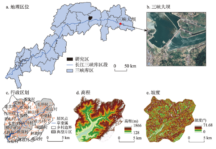
草堂溪流域(31°02′40″N~31°10′06″N, 109°31′03″E~109°45′20″E)主体位于三峡库区奉节县草堂镇(图1),流域面积约191.53 km2。草堂溪是长江北岸东北—西南走向的一级支流,主要有东、西两支支流。区内地貌类型以中低山和河流为主,海拔为128~1866 m,耕地主要分布于6°~25°的坡地上,坡地开垦过度,水土流失现象严重[22]。为治理生态问题,奉节县在实行退耕还林还草的同时在草堂溪两岸低海拔地段种植脐橙。因此,区域内存在森林的自然扩张和明显的耕—果转换,且多发生于道路、河流以及聚落周边[14]。综上,以草堂溪流域作为研究区可很好地反映山区农业景观格局的转型情况。图1
 新窗口打开|下载原图ZIP|生成PPT
图1研究区概况
Fig. 1Location map of the study area
3 理论构建、数据来源与研究方法
3.1 山区农业景观格局转型理论
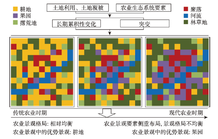
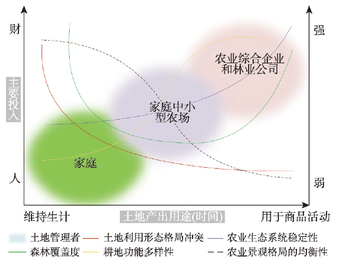
山区的乡村转型、土地利用转型[9]以及传统农业生态系统转型[20]会导致农业景观要素时空分布的变化,这种变化累积到一定程度,必然会引起农业景观格局的明显转型(图2)。因此本文在土地利用转型、传统农业生态系统转型和耕地功能转型等研究基础上,提出农业景观格局转型。农业景观格局转型是指农地利用和农户行为的长期累积变化或突变引起的农业景观组成单元的类型、数目及空间分布与配置发生根本性变化,导致农业景观由一种格局形态演变为另一种格局形态,由一种功能演变为另一种功能或多种功能,并且其演变趋势也发生转折性变化(图3)。农业景观格局转型包括土地管理者从满足自需的家庭变成满足市场需求的公司和企业,农业景观择优布局,景观均衡性降低,耕地功能由单一的生产功能转型为生态或生态经济多功能。同时,基于实地调研和长期思考,本文也进一步提出山区农业景观格局并不完全按照疆土开垦、生计农业、逐步集约化和集约利用阶段转型[23]这几个阶段发生演变转型,至少在中国,近年来山区农业景观格局演变有着其独特性。图2
 新窗口打开|下载原图ZIP|生成PPT
图2山区乡村农业景观格局转型示意图
Fig. 2A sketch of the rural agricultural landscape pattern transformation in mountainous areas
图3
 新窗口打开|下载原图ZIP|生成PPT
图3山区乡村农业景观格局转型理论框架
Fig. 3A theoretical framework of rural agricultural landscape pattern transformation in mountainous areas
3.2 数据来源与处理
2000年、2010年和2018年景观类型数据获自Google Earth(分辨率为0.51 m)高分辨遥感影像,参照“GDPJ01—2017”地理国情普查内容与指标,结合区域实际情况,在ArcGIS 10.2上通过目视解译将景观划分为坡耕地、未利用地、道路、果园、有林地、草地、河流、建设用地(生态产业园、机场)、灌木林地、聚落以及撂荒地11类,并根据野外调研进行核准。将景观类型图斑转换为5 m×5 m的栅格格式,通过Fragstats 4.2进行景观指数的计算。1∶50000的高程数据取自地理空间数据云平台。研究区的2000—2018年乡镇经济和人口数据是通过查阅《奉节年鉴·乡镇篇》和团队实地调研所得。3.3 研究方法
3.3.1 景观指数选取 景观格局指数能反映出高度浓缩的景观格局信息,是定量分析景观结构组成和空间配置的简单指标[24]。为全面反映景观空间格局特征和避免景观格局信息冗余,参照前人相关研究[25]及区域概况,本文选取类型水平上的景观百分比(PLAND)、聚集度指数(AI)和景观水平上的聚集度指数(AI*)、蔓延度指数(CONTAG)和香浓多样性指数(SHDI)用于景观格局特征的分析。相关研究表明这些指数能较好反映景观格局特征[25]。各指数的生态学意义和相关算法详见参考文献[24]。3.3.2 移动窗口法 移动窗口法是分析景观格局指数空间分异的有效手段[26],Whittaker最早提出移动窗口法用于植被沿水分梯度变化情况的分析[27],随后应用于城乡交错带的景观异质性研究[28],其运行原理是在研究区内选取一定大小的窗口进行移动,通过统计计算窗口内所选的景观指标,输出对应的栅格图,观察景观格局的空间变异状况。
3.3.3 典型片区选取和农户耕作范围确定 因农户住宅的变迁对其耕作范围内坡耕地的利用及转型有一定的影响[29],因此本文选取草堂溪流域中坡耕地面积大且转型明显的八阵村、柑子社区、欧营村、石马村、毛坪村、中梁村和天坪村作为典型片区,分析农户耕作范围内主要农业景观的涨落变化情况。借鉴角媛梅等[30]的“均等法”,将300 m、400 m和500 m的缓冲区与景观类型叠加,统计缓冲区内耕地、果园和撂荒地的面积。统计结果表明,将聚落周边400 m缓冲区作为农户的空间耕作半径最为合适。如表1所示,以聚落为中心做400 m缓冲区时,缓冲区内的耕地面积达到各片区耕地总面积的94%以上,覆盖的果园面积达99%以上。
Tab. 1
表1
表1典型片区聚落400 m缓冲区内的耕地、果园和撂荒地
Tab. 1
| 典型片区 | 总面积(hm2) | 400 m缓冲区内面积占比(%) | |||||
|---|---|---|---|---|---|---|---|
| 耕地 | 果园 | 撂荒地 | 耕地 | 果园 | 撂荒地 | ||
| 八阵村 | 219.57 | 247.40 | 33.04 | 94.79 | 99.27 | 98.75 | |
| 柑子社区 | 123.59 | 160.15 | 20.25 | 98.98 | 100.00 | 87.51 | |
| 毛坪村 | 408.88 | 168.06 | 122.21 | 99.70 | 100.00 | 73.01 | |
| 欧营村 | 598.94 | 693.00 | 108.14 | 99.69 | 99.55 | 95.02 | |
| 石马村 | 491.28 | 437.73 | 102.70 | 99.79 | 99.48 | 98.46 | |
| 天坪村 | 436.75 | 89.76 | 177.09 | 99.99 | 100.00 | 98.28 | |
| 中梁村 | 319.99 | 1.14 | 104.68 | 99.76 | 100.00 | 99.46 | |
新窗口打开|下载CSV
4 结果分析
4.1 研究区景观格局时空特征
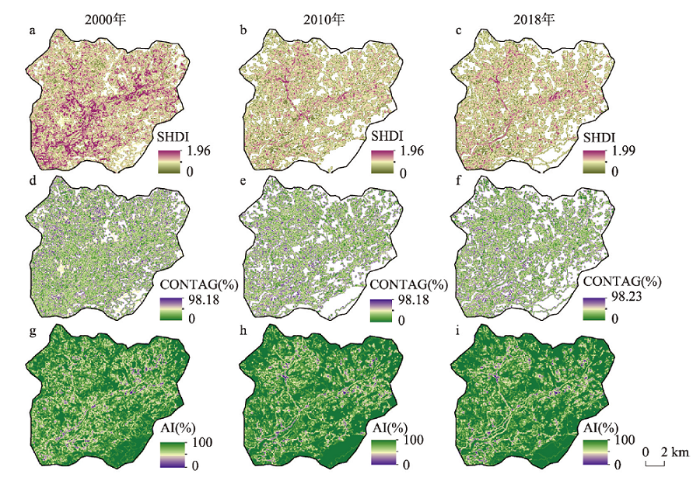
2000—2018年研究区整体多样性指数SHDI逐渐增加,CONTAG逐年递减,AI*逐渐增强(表2),说明研究区景观格局趋于多元化,斑块逐渐破碎但聚集性增强,这与撂荒地和果园景观的出现和扩张有关。从空间上看,不同地形上景观多样性差异明显,主要表现在河谷景观多元化,非河谷区域均值化(图4);蔓延度局部差异不大,2000年的高值区主要位于区域西北部的坡耕地区域,到2018年转移到河流下游的果园区域;聚集度的低值区明显缩减,景观的集聚性增强。Tab. 2
表2
表2研究区景观水平上的指数变化
Tab. 2
| 年份 | SHDI | CONTAG(%) | AI*(%) |
|---|---|---|---|
| 2000 | 1.58 | 61.50 | 95.04 |
| 2010 | 1.74 | 59.03 | 95.97 |
| 2018 | 1.76 | 58.48 | 96.01 |
新窗口打开|下载CSV
图4
 新窗口打开|下载原图ZIP|生成PPT
图4研究区景观格局指数的时空分布
Fig. 4Spatio-temporal distribution of landscape pattern indices in the study area
4.2 主要农业景观的空间格局特征
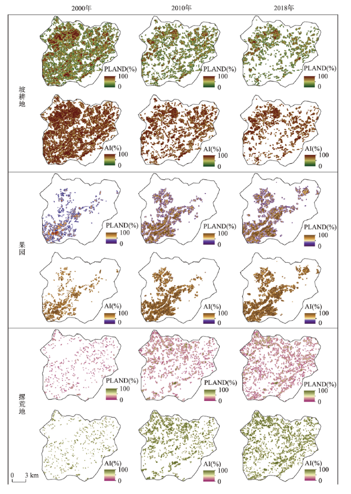
格网上的PLAND、AI值时空变化情况显示(图5),从2000年到2018年研究区坡耕地、撂荒地以及果园的空间分布发生了较大变化。2000年,坡耕地全域相对均匀分布,西北部坡度较小的河谷地区聚集性较强,到2018年全域坡耕地明显缩减,斑块破碎,但其优势区仍在西北部的小坡度河谷地区。2000年果园主要分布在研究区西南干流及东支支流的低海拔区域,斑块百分比和聚集度较低,说明斑块较细碎。随着农户生计转型和政府扶持,到2018年,果园分布逐渐向四周扩张,河流两岸的果园聚集度加强,斑块面积变大。撂荒地在2000年呈点状无序分布格局,坡耕地的退耕还林和撂荒导致了撂荒地面积扩张,到2018年撂荒地斑块密集程度增加,主要集中于流域海拔700 m以上区域。图5
 新窗口打开|下载原图ZIP|生成PPT
图5研究区坡耕地、果园和撂荒地的时空分布格局
Fig. 5Spatio-temporal pattern of sloping farmland, orchards and abandoned land in the study area
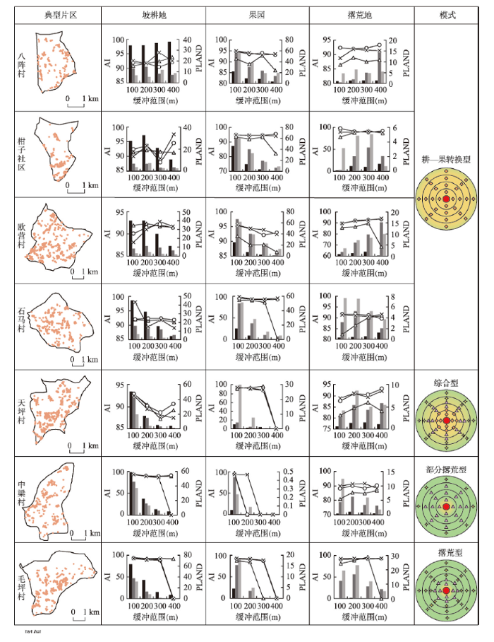
4.3 典型片区农户耕作范围内主要农业景观涨落变换情况
大部分典型片区的坡耕地和果园在特定年份分布于聚落的300 m缓冲区内,导致其景观指数在300~400 m的缓冲区间骤降为0(图6),因此分析景观指数在缓冲距离上的变化时只保留主要变化趋势。随缓冲距离的增加,大多片区坡耕地和果园的PLAND和AI波动减小,其中欧营村和柑子社区的坡耕地PLAND随缓冲距离先增后减,整体上呈减小趋势,石马村、毛坪村、中梁村和天坪村耕地的PLAND和AI波动减少,只有八阵村的坡耕地随缓冲距离略微增加,这是由于八阵村的聚落400m缓冲区包含的耕地数量占比较少(表1),有较多耕地未统计。八阵村、柑子社区、欧营村和毛坪村撂荒地的PLAND随缓冲距离波动增加。八阵村、欧营村、毛坪村、中梁村和天坪村撂荒地的AI随缓冲距离波动增加。图6
 新窗口打开|下载原图ZIP|生成PPT
图6典型片区农户耕作范围内坡耕地、果园以及撂荒地的数量变化
Fig. 6Changes in sloping farmland, orchard and abandoned land within the farmers' farming range in typical areas
从时间上看,2000—2018年各缓冲环内坡耕地的PLAND波动减小,而撂荒地和果园的PLAND和AI值波动增加,反映出典型片区聚落附近都出现了不同程度的耕—果转换和坡耕地撂荒。2000年,位于河谷的八阵村、柑子社区、欧营村和石马村在聚落400 m范围内的坡耕地面积大于果园面积,到2018年,果园面积大于坡耕地,表明坡耕地向果园大幅度转化,坡耕地的集约利用明显;2000年,东北部的毛坪村各缓冲环内的相对优势景观皆为坡耕地,到2018年,聚落100 m内的优势景观变为果园,果园聚集度增强,100~200 m之间不变,200~400 m变为撂荒地,表明坡耕地的撂荒和集约利用并存;而东北部的中梁村聚落300 m内的坡耕地虽在持续向撂荒地转化但仍占有明显优势,在300~400 m缓冲区,撂荒地成为优势景观;西北部的天坪村聚落100 m内耕地在向撂荒地和果园转变,但坡耕地仍占有主导地位,在100 m以外的区域,坡耕地主要向撂荒地转变,优势景观变为撂荒地。
通过对以上片区在农户耕作范围内以坡耕地、撂荒地和果园为代表的农业景观格局的研究可以归纳出4种农业景观格局转型模式(图6):① 耕—果转换型:坡耕地收缩,果园迅速聚集发展成为主导景观,以八阵村、柑子社区、欧营村和石马村为典型;② 综合型:离聚落较近处以耕—果转换为主导,离聚落较远处以耕地撂荒为主,其优势景观从聚落到远处分别为果园、坡耕地、撂荒地,以毛坪村为典型;③ 部分撂荒型:聚落400 m缓冲范围内耕地发生撂荒,但坡耕地在大部分区域仍为优势景观,离聚落较远处撂荒地为优势景观,以中梁村为典型;④ 撂荒型:在聚落400 m缓冲范围内,果园占比小,耕—果转换不明显,坡耕地向撂荒地大幅度转变,撂荒地为优势景观,以天坪村为典型。
5 讨论
5.1 研究区农业景观格局转型趋势
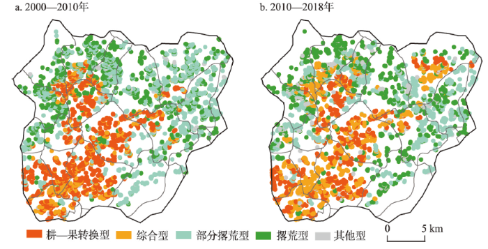
通过对各典型片区农业景观格局转型特征的分析,归纳为耕—果转换型、综合型、部分撂荒型和撂荒型4种农业景观格局转型模式,将以上模式应用到流域所有聚落,以探究各模式在整个区域的分布情况。研究区各聚落400 m缓冲区的农业景观格局转型模式除耕—果转换型、综合型、部分撂荒型和撂荒型以外,还存在其他型。但研究区域以上述的4种模式为主,且各模式在各典型片区的空间分布符合该片区农业景观格局转型的整体特征(图7)。耕—果转换型和综合型主要集中分布于河谷片区,与果园的分布格局基本重合。部分撂荒型和撂荒型与耕地和撂荒地的分布空间大致吻合。图7
 新窗口打开|下载原图ZIP|生成PPT
图72000—2018年研究区农业景观格局转型结果
Fig. 7Transformation results of agricultural landscape pattern in the study area from 2000 to 2018
耕—果转换型、综合型、部分撂荒型和撂荒型揭示了山区农业景观格局的发展过程,其中部分撂荒型代表着山区农业景观格局转型的起点,对应的农业系统模式为传统小型生计农业[31]。在山区农村,部分撂荒型有两条转型轨迹,其一是在农户生计转型的驱动下,逐渐演变成综合型,随着耕—果转换规模的进一步扩大,立地条件好的区域农业景观格局发生转型,形成集约利用的耕—果转换型模式,这与三峡库区农业生态系统模式高低高—低高低—低低高转型轨迹的实质一致[20];其二是在环境限制或生态需求下直接发展为撂荒型,这是山区农地退化的表现[13]。
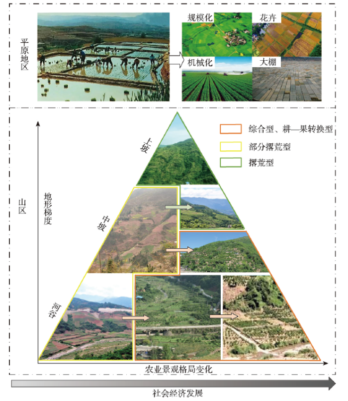
本文3.1里已提出,有研究者将土地利用发展阶段分为史前时期、疆土开垦时期到集约利用时期[23],但这些土地利用阶段和景观格局演变可能只代表平原地区的土地利用演变和景观格局演变,在山区,存在着与平原区不一样的土地利用转型与景观格局转型。本文的案例研究表明,山区的景观格局演变有着其独特性(图8):不同于平原区单向的集约化态势,山区的农业景观格局转型具有双向性,不单是向着集约化的方向转型,坡耕地撂荒也是其显著特征。另外,山区农业景观格局转型也有垂直空间上的变化,地形梯度越大,农业景观格局转型的生态导向性越强,地形梯度越小,农业景观格局转型的经济导向性越强。因此可以认为山区的农业景观格局转型是立体的双向转型模式。本文以典型实例研究,揭示了山区景观格局转型演变过程和其特殊性,是在以往研究基础上的进一步发展,具有较强的理论意义。
图8
 新窗口打开|下载原图ZIP|生成PPT
图8山区和平原的农业景观格局变化对比
注:山区的照片均为研究团队摄于草堂镇。
Fig. 8Comparison of changes in agricultural landscape patterns between mountains and plains
5.2 研究区农业景观格局转型的驱动机制
本文采用定性与定量相结合的方法从自然、人口、农业经济以及政策方面分析区域农业景观格局转型的驱动机制。因草堂镇约占草堂溪流域面积90%,因此本文主要以草堂镇的社会经济统计数据代表流域进行驱动因素分析。景观格局在地形因子的作用下呈现出一定的地形梯度性[32],SPSS软件的双变量相关性分析结果表明(表3),撂荒地的PLAND和AI与海拔、坡度和起伏度呈正相关,坡耕地和果园的PLAND和AI与海拔、坡度和起伏度呈负相关。海拔对果园分布的影响最为明显,而在适宜果园生长的海拔区间内,坡度和起伏度的影响较小,因此坡度、起伏度与果园的景观格局指数相关性较低。另外,在立地条件极差的区域基本是高覆盖林地,因此该区域内坡耕地和撂荒地的指数变化与各地形因子的相关性不大。说明地形因子并不是影响研究区农业景观格局指数变化的主要因素,梁鑫源等也认为在乡镇水平上三峡库区农业转型的驱动力是以社会经济因素为主[18]。
Tab. 3
表3
表3农业景观格局指数与地形因子的相关系数
Tab. 3
| 地形因子 | 坡耕地 | 果园 | 撂荒地 | |||||
|---|---|---|---|---|---|---|---|---|
| PLAND | AI | PLAND | AI | PLAND | AI | |||
| 海拔 | -0.061** | -0.099** | -0.526** | -0.552** | 0.019** | 0.006** | ||
| 坡度 | -0.067** | -0.029** | -0.121** | -0.069** | 0.038** | 0.028** | ||
| 起伏度 | -0.140** | -0.092** | -0.214** | -0.170** | 0.034** | 0.024** | ||
新窗口打开|下载CSV
图9表明,在地形的限制下,研究流域中聚落和以聚落为中心的农业景观系统转型模式主要集中在坡度10°~40°、地形起伏度80~240 m区间。2000—2018年耕—果转换型和综合型主要集中在海拔的200~700 m区间,部分撂荒型和撂荒型主要在海拔700 m以上地区集聚,其他型主要分布在海拔1000 m以上区域。
图9
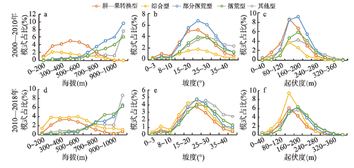 新窗口打开|下载原图ZIP|生成PPT
图9草堂溪流域农业景观格局转型模式的空间分布规律
Fig. 9Spatio-temporal distribution of different modes for agricultural landscape pattern transformation in Caotangxi watershed
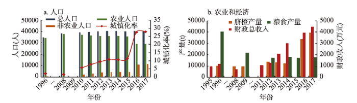
1996年草堂镇城镇人口仅占总人口的1.99%,2017年达到28.04%,人口城镇化率显著提高(图10a)。城镇化导致的乡村地区劳动力转移是山区农村土地利用转型最直接的驱动力[33]。实地访谈表明,农民对土地的依赖性逐渐降低,农民主要生计来源以进城务工等非农收入为主。男性青壮年劳动力的转移导致了农村地区劳动力的老龄化和女性化,这增大了耕地的遗弃风险[34]。
图10
 新窗口打开|下载原图ZIP|生成PPT
图10草堂镇的部分社会经济统计数据
Fig. 10Partial socio-economic statistics of Caotang town
1995—2017年草堂镇脐橙产量明显增加,而粮食产量逐渐减少(图10b),其原因之一是果园面积增加,耕地面积减少,另外脐橙种植技术的提升和果园规模化的管理提升了脐橙的产量。1995—2017年草堂镇的年度财政总收入迅速增加,当地农民生活消费水平明显提高,这为区域的农业景观格局转型打下了坚实的财力基础。
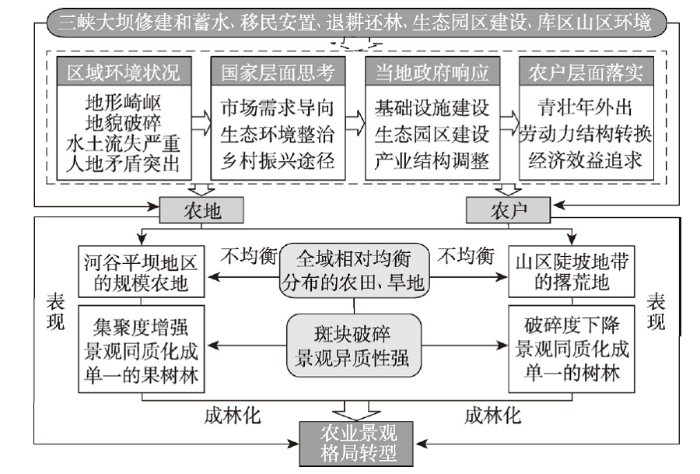
政策对土地利用和景观格局的变化具有重要的导向作用[35]。1998年后政府发起的退耕还林促进了区域坡耕地撂荒和果园景观的形成;脱贫致富和全面小康对农户生计提升的要求促使农业转型,导致山区农村劳动力由传统务农型逐渐向现代型、兼业型和务工型转型。另外,农地所有权对农业景观格局和功能也有显著的影响[36]。在研究时段内,中国实行包产到户的土地政策,而山区各户的土地分散且细碎,因此,当一些农户退耕时撂荒地景观呈点星状而非块状的分布格局。果园的块状连续分布与政府对林果业发展的扶持密不可分[37]。总的来说,三峡库区山区的农业景观格局转型是在以社会经济因素为主的驱动下,从传统均衡分布的粮食作物农业景观向河谷的生态经济双赢景观和较高海拔的生态景观转变(图11)。
图11
 新窗口打开|下载原图ZIP|生成PPT
图11三峡库区山区农业景观格局转型驱动机制
Fig. 11Transformation driving mechanism of agricultural landscape pattern in mountainous areas, Three Gorges Reservoir Area
5.3 研究区农业景观格局转型的效应
目前研究区的粮食作物景观随土地利用结构的重新配置和农户生计方式的改变迅速缩减,在海拔700 m以上区域转变为零星破碎的撂荒地,在低海拔河谷转变为集约连片的经果林,这是社会经济发展驱使的诱致性生产替代[10]。其整体农业生产从单一均匀的分布格局转向侧重河谷布局的多元化格局,由单功能的农业景观向生态经济双赢的景观转型,符合国土空间规划对三峡库区水土保持生态功能区的定位。从三峡工程的建设到运营,库区的生态经济双赢农业在库区土地整理和森林保护工程的部署下逐渐成为带动各区县经济快速发展的特色农业[18, 37]。其他****对其他地区的研究也一致认为山区的经果林农业是保证区域经济生态双赢的有效途径[38,39],与华北平原的“杨上粮下”和青藏高原的“设施农业”发展模式对区域经济生态可持续发展的作用相同[40,41]。研究区的经济生态双赢可持续农业景观格局的转型也在流域尺度上解释了中国如何通过土地整治引领世界变绿[42]。需要指出的是,在草堂溪流域的农业景观的转型改善了坡耕地水土流失状况,果园的发展使区域能实现生态经济双重效益,但流域具有优势的农田景观由有季节性变化的农作物景观变为常年单一的脐橙果园景观,对于更小的农田生态系统来说,其稳定性随农田景观多样性的减少而下降。虽然草堂溪流域果园种植的起始目的是为了防止水土流失,但调查发现,农户为保证脐橙的产量往往会清除果树下的杂草灌木,导致果园的土壤裸露及土壤养分严重流失,有证据表明随着脐橙种植年限的延长,土壤养分的供应与果树的生长需求越来越不协调,土壤质量受到严重影响[43]。因此,在研究区可以推行果—蔬、果—经兼种的种植方式,增强果园植被覆盖度,可以更好地实现农业景观的可持续生态经济双赢。
另一方面,山区农村耕地的转型影响了粮食播种面积,这在宏观上可能会影响国家的粮食安全,在区域和家庭层面可能影响区域经济发展和农户生计保障。但实际上山区的土地质量差,粮食生产率低,且西欧和美国的例子已证实平原地区优质耕地的集约化生产带来粮食的增产可以抵消山区劣质耕地弃耕导致的粮食减产[44,45]。山区乡村经济的衰落意味着区域整体社会经济发展布局的优化,且因农户作为理性经济人的自发追求[15],农户生计方式改变带来的非农收益往往大于务农收益[46]。因此,山区农村土地整治应顺应区域土地利用转型规律,遵循国土空间功能规划定位,转向全面提高库区国土空间利用质量和百姓福祉。
6 结论
本文通过“理论分析—实证研究—趋势预测”的方式从“整体—微观”的角度出发对三峡库区山区以坡耕地、撂荒地和果园为代表的农业景观格局动态变化特征及转型趋势进行解析,主要结论如下:根据山区土地利用转型、传统农业生态系统转型和耕地功能转型等研究,本文提出山区农业景观格局转型理论,并以草堂溪流域为例,研究发现,2000—2018年三峡库区山区较高海拔地区的撂荒地和河谷经果林景观的出现和扩张导致区域景观多样性的整体增强,而在局部地形上差异明显,景观斑块愈发破碎但聚集度逐渐增强。
将聚落的400 m缓冲区作为探究农户耕作半径内以坡耕地、撂荒地和果园为代表的农业景观格局转型的研究单元,总结出部分撂荒型、综合型、耕—果转换型和撂荒型4种农业景观格局的转型模式,这4种模式揭示了山区农业景观格局的双向转型过程,具体表现为部分撂荒型—综合型—耕果转换型以及部分撂荒型—撂荒型的两条路径。
三峡库区山区的农业景观格局在以经济社会因素为主的驱动下,通过坡耕地退耕和经果林种植的方式逐渐由单一均匀分布的粮食作物农业景观向河谷的经果林景观和较高海拔的撂荒地发生转型,表现出三峡库区山区农业景观格局由单功能向生态经济双赢景观格局的转型过程,反映了山区农业景观格局演变的独特性。
本文缺乏对农业景观格局转型后经济、生态效应的定量研究,下一步将评价农业景观转型的生态系统服务价值;其次文章确定的农户空间耕作半径仅反映农村居民点到耕作区的直线距离,而山区的实际耕作距离往往大于400 m;本文主要分析了研究区坡耕地的撂荒和果园化,而三峡库区山区还建设有少量茶园和蔬菜大棚等,所以对区域农业景观格局空间特征的反映可能不全面,但研究结果仍能反映三峡库区山区农业景观格局主要转型方向和趋势。
参考文献 原文顺序
文献年度倒序
文中引用次数倒序
被引期刊影响因子
DOI:10.1016/j.ecolind.2014.11.025URL [本文引用: 1]
DOI:10.1016/j.landusepol.2008.04.001URL [本文引用: 1]
DOI:10.1016/j.landusepol.2015.05.009URL [本文引用: 1]
DOI:10.1016/j.jenvman.2014.05.014URL [本文引用: 1]
[本文引用: 1]
[本文引用: 1]
DOI:10.1016/j.agee.2005.11.012URL [本文引用: 1]
DOI:10.1016/j.landusepol.2016.11.025URL [本文引用: 1]
DOI:10.1016/j.landusepol.2004.03.003URL [本文引用: 1]
DOI:10.11820/dlkxjz.2012.02.001 [本文引用: 2]

Recently, related researches on land use transition combining with the characteristics of China’s socio- economic development have been carried out rapidly since the research field of land use transition was introduced to China. Land use morphology is the key content of land use transition research. However, the concept and connotation of land use morphology has been developed continuously with the in-depth research and socio- economic change and innovation. Based on the analysis of the evolvement of the concept and connotation of land use morphology, this paper argues that there are two formats for depicting land use morphology: one is dominant morphology, and the other is recessive morphology. The dominant land use morphology refers to the quantity, structure and spatial pattern of land use, and the recessive land use morphology includes the land-use features in the aspects such as quality, property rights, management mode, fixed input and productive ability. Then, a conceptualization of the models of land use transition was annotated based on the two formats of land use morphology. Land use transition refers to the changes in land use morphology of a certain region over a certain period of time driven by socio-economic change and innovation, and it usually corresponds to the transition of socio-economic development phase. Rural transformation development means the restructuring of rural socio- economic morphology and territorial spatial patterns resulted from local actors’responses and readjustments to the change, recombination and interaction of socio-economic development factors and rural-urban migration in the process of rapid urbanization and industrialization, including the changes in traditional rural industries, the employment mode, the consumption structure, and the social structure. Such transformation radically changes the urban-rural relationship and the relationship between agriculture and industry. Since farmland and rural settlement are the engines driving land use transition and rural transformation development, the interaction between rural transformation development and farmland and rural settlement transition was analyzed to understand the relationship between land use transition and rural transformation development. Finally, the future research fields concerning land use transition and rural transformation development were suggested as follows: the dynamic pattern and territorial type of land use transition and rural transformation development; the interaction and dynamical mechanism of land use transition and rural transformation development; the resources and environment effects of land use transition and rural transformation development; and the ways and countermeasures of optimizing and adjusting land use transition and rural transformation development.
[本文引用: 2]
DOI:10.11821/dlxb201905012 [本文引用: 2]
Changes of cultivated land use structures including type structure, input structure, and plantation structure, could succinctly reveal change of cultivated land use function morphology. Cultivated land use function transition (CLUFT) in the process of socio-economic development, however, is currently an issue to be resolved. Based on the underlying relationship between induced production substitution and cultivated land use structure change, this paper established a comprehensive explanation framework of the CLUFT. Then, the regional CLUFT was studied with Guangdong province as a typical case area. Results show that cultivated land use functional morphology in Guangdong overall entered the interim stage of the transition from socio-economic morphology to ecological and economic morphology. Cultivated land use function in the Pearl River Delta has accomplished the transition from socio-economic morphology to ecological-economic morphology. The rest of districts of Guangdong, however, accomplished the transition from socio-ecological morphology to socio-economic morphology. Both socio-economic and institutional forces drove the CLUFT in Guangdong. Mechanism of the CLUFT behaves as cascading effects of interactions among urbanization, socio-economic development, induced production substitution, changes of cultivated land use structures, and transformation of cultivated land use function morphologies. The positive analysis above justified the comprehensive explanation framework presented in this paper. That is, changes of cultivated land use structures could effectively denote cultivated land use function transition. With socio-economic development from its primary stage to an advanced one, changes of cultivated land use structures will drive transition of cultivated land use function morphology from socio-ecological morphology to socio-economic morphology, and to ecological and economic morphology under the direct force of induced production substitution. This paper presented new knowledges on morphology and transition explanations in land use transition research. Furthermore, new knowledges on the underlying mechanism of cultivated land use transition has been developed based on rethinking of the induced production substitution in agriculture. This study is of significance to bridge the knowledge gap of cultivated land use transition among scholars, the public, and policy makers and to deepen further research on land use transition. Finally, suggestions on transformation from dryland to paddy filed in southern China and control of socio-ecological effects of cultivated land use function transition were discussed.
[本文引用: 2]
DOI:10.1007/s11442-015-1197-4URL [本文引用: 1]
[本文引用: 2]
DOI:10.11821/dlxb201805002 [本文引用: 2]
Farmland marginalization has become the main trend of land-use change in the mountainous areas of China. Using the China Agricultural Production Costs and Returns Compilation (annual survey data of major agricultural production costs and earnings at national and provincial levels), this paper first analyzed the changes in the cost structure of agricultural production and the farmers' responses, under the context of the rapid rise in agricultural labor prices since 2003, and further compared the responses from the mountainous and plain regions. We found that farmers on the plains have reduced their labor input effectively through intensive use of agricultural machinery, which has minimized the impact of the increase in labor price. However, it is a severe challenge for farmers in the mountainous areas to use the same method due to the rough terrains. Thus, the agricultural labor productivity in these areas has increased relatively slowly, causing a widening gap in agricultural labor productivity between the two regions. With the rapid rise in labor costs, the marginalization of cultivated land in the mountainous areas is evident. In 2013, the profit of agricultural production in mountainous China, which takes maize cultivation as a representative, has fallen below zero. Since 2000, the land-use and land cover change in these areas has been characterized by the reduction of farmland area, reforestation, and the enhancement of the NDVI value. The high correlation between the NDVI change rate and the ratio of change in farmland (r = -0.70) and forest (r = 0.91) areas in mountainous areas at provincial level from 2000 to 2010, attests to the trend of farmland marginalization there. Finally, according to the analysis results, we summarized the mechanism of such marginalization against the backdrop of the rapid increase in the opportunity cost of farming and the sharp fall of agricultural labor forces. This study contributes to a deep understanding of the development process of farmland abandonment and forest transformation in the mountainous areas of China.
[本文引用: 2]
DOI:10.31497/zrzyxb.20190214URL [本文引用: 2]
[本文引用: 2]
DOI:10.11821/dlxb201803009 [本文引用: 2]
In agricultural society, the cultivation of mountainous land was a representative of intensified contradiction between human and land which resulted in water loss and soil erosion. With the rapid urbanization and industrialization in poverty-stricken mountainous areas, the labor emigration relieves this contradiction significantly, and leads to land use transition, which results in a series of natural and socio-economic changes. This research built an analysis framework of "Land use transition - driving mechanism - effects - responses" in mountainous land use transition and then put forward the further direction of mountainous land reclamation. The results indicate that: (1) The tendency change of land use morphology was the core of rural land use transition in mountainous areas. The expansion of cropland, as well as the contraction of forest land in agricultural society, has changed to the abandonment of cropland and the expansion of forest land is the main characteristic of the dominant land use morphology transition. Land marginalization and land ecological functional recovery are the main characteristics of the recessive land use morphology transition in mountainous areas. (2) Socio-economic factors are the primary driving forces during the mountainous land use transition. Labor emigration is the direct driving forces. Meanwhile, the rising costs of farming opportunities, and the harsh living environment that lead to labor emigration are the root cause for mountainous land use transition. (3) The transition of rural land use in mountainous areas reduces the vulnerability of land ecosystem and improves its ecological security barrier function. The advantages and disadvantages of its socio-economic effects should focus on rural development of mountainous areas and the livelihood of farmers, and need to be supported by empirical and quantitative researches. (4) The transition of land use in rural areas is a benign process of natural restoration and ecological optimization. The rural land remediation in mountainous areas should conform to the law of land use transition, and the target orientation will shift from the increase of cultivated land to the synergies of ecological and environmental protection.
[本文引用: 2]
PMID:11767611 [本文引用: 1]
Based on the theories of landscape ecology, this paper discussed the principles and methods of ecological planning and designing in agricultural landscapes. It is suggested that the ecological planning and designing in agricultural landscapes became an important applied field of landscape ecology, due to the characteristics of microspatiality, and correlation and integration involved problems. The Zhuolu basin, located in the semiarid region of northwest Hebei Province was chosen as a case study.
PMID:11767611 [本文引用: 1]
DOI:10.1007/s12665-015-4443-2URL [本文引用: 1]
DOI:10.11821/dlxb201809002 [本文引用: 3]
The discussion on function transformation of agricultural utilization and its corresponding driving mechanism in the Three Gorges Reservoir Area (TGRA) can reflect the change of the relationship between people and environment in the transitional belt between central and western China, mountainous areas and reservoir area, and provide a scientific basis for the development of agricultural multi-function in typical mountainous areas. This paper, selected five counties from the hinterland of the TGRA as the study area, analyzed the change of scaling farmland and its corresponding mechanism by defining the concepts of "scaling farmland", with the aid of Arcgis10.2, SPSS, geodetectors and other technical means. Results show that the scaling farmland was mainly converted from cultivated land and shrubland. Apart from some land used for alpine off-season vegetables, the growth of scaling farmland generally occurred at low altitude, and was mainly found in the range with a slope of 30°. The spatial change of scaling farmland of different types was significantly different, which was closely related with road and township administrative center. At the patch level, natural factors such as elevation and slope contribute much to the scaling farmland. At the township level, the driving forces of socioeconomic and humanistic factors were attributed to road traffic, agricultural population density and so on. At the regional level, the influencing factors of each county were more significant than those of the study area. The change and development of scaling farmland was driven by many factors. But the agricultural policy had been one of the dominant factors. Behavior subjects at different levels would promote the scaling farmland development in different directions under the background of national agricultural development and policy implementation.
[本文引用: 3]
[本文引用: 1]
DOI:10.1007/s11442-020-1728-5URL [本文引用: 3]
[本文引用: 1]
[本文引用: 1]
[本文引用: 1]
DOI:10.1126/science.1111772URL [本文引用: 2]
[本文引用: 2]
[本文引用: 2]
DOI:10.1016/j.ecolind.2009.04.017URL [本文引用: 2]
DOI:10.1016/j.landurbplan.2005.07.006URL [本文引用: 1]
[本文引用: 1]
[本文引用: 1]
[本文引用: 1]
[本文引用: 1]
[本文引用: 1]
[本文引用: 1]
[本文引用: 1]
[本文引用: 1]
[本文引用: 1]
[本文引用: 1]
DOI:10.1007/s11442-017-1426-0URL [本文引用: 1]
[本文引用: 1]
DOI:10.1016/j.landusepol.2006.05.005URL [本文引用: 1]
DOI:10.1016/j.landusepol.2016.06.032URL [本文引用: 1]
[本文引用: 2]
[本文引用: 2]
DOI:10.1016/j.landusepol.2009.09.003URL [本文引用: 1]
DOI:10.1007/s10980-019-00852-5 [本文引用: 1]
ContextEuropean agricultural landscapes are facing contradictory phenomena in that some areas are experiencing unsustainable land-use intensification while others are being abandoned. Specifically, agricultural intensification is increasing resulting in numerous negative environmental impacts on European soils, water and biodiversity; increased crop ecological footprints; and creation of social conflicts and inequalities. Within this context, we mapped and assessed ecosystem services fromSpanish agricultural landscapes to identify ecological and economical win-win situations that could provide good examples of sustainable landscape management.ObjectivesWe aim to spatially identify gaps and areas of overlap of ecological and economic values of ecosystem servicesat the national scale for Spanish agricultural landscapes. Additionally, we analyse possible connections among social concerns and preferences related to environmental issues and ecosystem services with economic and ecological values of local agricultural landscapes.MethodsFirst, we quantified and mapped the economic value of crop production at the national level. Second, we mapped the ecological value of agricultural landscapes based on the high nature value farming index. Third, we explored the spatial correlations between economic and ecological values to identify major agricultural landscape patterns at the national level and specific win-win situations at the local level. Fourth, we conducted a public survey of the Spanish population about environmental concerns and their preferences towards ecosystem services. Fifth, we analysed the links among the social concerns and preferences with the ecological and economic values of agricultural landscapes at the national level.ResultsOur results allow us to better understand the main landscape patterns and help develop more balanced management strategies. For instance, the results show how current landscape management in Spain is polarized between areas with high economic values and areas with high ecological performance. The maps produced also allow the identification of agricultural landscapes with high economic and ecological values that can be used as good examples for sustainable landscape management. Additionally, the public survey revealed that environmental concerns of the Spanish population and the importance the population places on agricultural ecosystem services received very low scores.ConclusionsThe results from this study show that the possibility of balancing and reconciling the supply of ecological and economic values from agricultural landscapes exists in practice. The results help identify areas in Spain where actions should be taken to enhance sustainable landscape planning at the national level. Among the analysed environmental concerns of the Spanish population, the three environmental concerns that had the lowest scores are those that are tightly linked to the type of action needed to shift towards more sustainable agroecological systems. Finally, we discuss how complex interactions among ecosystem services should become part of the planning strategies for new sustainable landscape management at the national level.
[本文引用: 1]
[本文引用: 1]
[本文引用: 1]
[本文引用: 1]
DOI:10.1038/s41893-019-0220-7PMID:30778399 [本文引用: 1]
Satellite data show increasing leaf area of vegetation due to direct (human land-use management) and indirect factors (climate change, CO fertilization, nitrogen deposition, recovery from natural disturbances, etc.). Among these, climate change and CO fertilization effect seem to be the dominant drivers. However, recent satellite data (2000-2017) reveal a greening pattern that is strikingly prominent in China and India, and overlapping with croplands world-wide. China alone accounts for 25% of the global net increase in leaf area with only 6.6% of global vegetated area. The greening in China is from forests (42%) and croplands (32%), but in India is mostly from croplands (82%) with minor contribution from forests (4.4%). China is engineering ambitious programs to conserve and expand forests with the goal of mitigating land degradation, air pollution and climate change. Food production in China and India has increased by over 35% since 2000 mostly due to increasing harvested area through multiple cropping facilitated by fertilizer use and surface/ground-water irrigation. Our results indicate that the direct factor is a key driver of the "Greening Earth", accounting for over a third, and likely more, of the observed net increase in green leaf area. They highlight the need for realistic representation of human land-use practices in Earth system models.
[本文引用: 1]
[本文引用: 1]
[本文引用: 1]
[本文引用: 1]
DOI:10.5814/j.issn.1674-764X.2016.01.008URL [本文引用: 1]
[本文引用: 1]
[本文引用: 1]
