 , 曹广超
, 曹广超New evidence of human activities at an altitude of 4000 meters area of Qinghai-Tibet Plateau
HOUGuangliang, CAOGuangchao收稿日期:2015-08-3
修回日期:2015-12-8
网络出版日期:2016-07-25
版权声明:2016《地理学报》编辑部本文是开放获取期刊文献,在以下情况下可以自由使用:学术研究、学术交流、科研教学等,但不允许用于商业目的.
基金资助:
作者简介:
-->
展开
摘要
关键词:
Abstract
Keywords:
-->0
PDF (5108KB)元数据多维度评价相关文章收藏文章
本文引用格式导出EndNoteRisBibtex收藏本文-->
青藏高原低温干燥、缺氧、紫外线强等极端环境,导致人类对其的适应有其特殊性。最近研究表明人类早在晚更新世末期的12.8-11.5 cal. ka BP已经在海拔4400 m的南美洲Peruvian Andes活动[1],人类向青藏高原的扩张也引起广泛注意[2]。从20世纪50年代起,在青海可可西里、昆仑山北麓三叉口、乌拉湖和柴达木盆地的冷湖、小柴旦湖畔,西藏的定日县的苏热、吉隆县仲嘎乡的哈东淌和却得淌、藏北申扎县的珠洛勒、班戈县的各听、阿里地区日土县的扎布、多格则等地点发现有旧石器晚期特征的石器[3-4],据此推测旧石器时代晚期人类已经在高原活动;但是由于这些石器多采自地表,缺乏地层堆积,难以对其科学定年;另外打制石器使用的年代非常宽泛,再加之高原考古文化石器表现出与内地相近特征,但时代普遍较晚[3];仅根据石器类型学和地质地貌进行断代或者推测年代,存在较大不确定性。例如小柴旦湖地点石器与华北晚更新世晚期旧石器特征较为一致,结合湖泊演化、地貌证据,推测该石器地点年代约为30 ka BP [5],但利用光释光法对其测年,年代在9.2 ka [6]。因此,目前虽然在青藏高原发现的旧石器及细石器地点已达100多处,但绝大部分石器地点年代仍难以确定,海拔4000 m以上少数进行科学定年的遗存,包括野牛沟[7]、西大滩[8]、参雄尕塑[9],其年代均落在8-6 cal. ka BP,据此推测4000 m高原上细石器遗存在全新世早中期[8]。
近些年在高原东北缘3000 m海拔地区发现了一些属于晚更新世末期,具有临时性或
季节性狩猎活动的人类活动遗存,包括江西沟、黑马河、娄拉水库、晏台东等[10-14],这些遗存年代大都在晚更新世的15-11.5 cal. ka BP,是目前可以确定的高原较早的人类活动,另外高原东北缘目前发现的材料相对较多,故本文选取高原东北缘揭示人类活动在此向高海拔扩张的历程,当然不排除高原西部存在较早人类活动[15]。青藏高原平均海拔4000 m,人类向高原扩张中,如果适应了海拔4000 m区域,意味着人类可以适应青藏高原的主体,因此,4000 m海拔是人类扩张高原的关键一环,尤其是高原东北缘,而本文所述的下大武遗存正是在这重要区域[12, 16],故通过该遗存的发现来探讨人类征服青藏高原的历程。
1 研究区简介
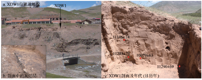
青海省东南部的果洛州平均海拔4200 m(图1),高寒缺氧,年均气温-4 ℃,年均降水量400~700 mm,全年无绝对无霜期。地形西北高,为较平缓的高原面;东南低,多高山与沟谷;巴颜喀拉山绵亘南部,阿尼玛卿山逶迤境北。境内河流较多,黄河几乎贯穿全境,有鄂陵湖、扎陵湖和冬给措纳等众多湖泊,植被类型以高山草甸为主,有少量的天然林地和耕地;全州主要居民为藏族,以畜牧业为主。玛沁县下大武乡,地处发育有现代冰川的阿尼玛卿主峰(6282 m)西麓,这里年均气温在-4 ℃以下,年均降水量462.9 mm,多集中在5-9月份,属于高原亚寒带半湿润气候,全年盛行西北风和东北风,春季风最大;高山草甸植被,野生动物资源丰富,栖息有原羚、马鹿、麝、岩羊、棕熊、野驴、猞猁、盘羊、雪豹、蓝马鸡和藏雪鸡等。下大武遗存(简称XDW1)位于阿尼玛卿雪山西南麓,地理位置35o0′7"N,99o15′38"E,海拔3988 m;XDW1处在黄河二级支流清水河西岸的阶地上(图2),阶地高出河床约15 m,阶地面宽30~150 m,阶地中部为下大武乡,遗迹在阶地南部。阶地堆积物具有明显的二元结构,上部约3 m为风成黄土状堆积物,3 m以下为砾石层。
 显示原图|下载原图ZIP|生成PPT
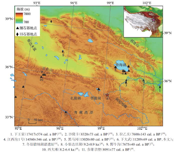
图1青藏高原东北缘旧石器—细石器遗址
-->Fig. 1Overview map of paleolithic-microlith relics in the marginal regions in northeastern Tibetan Plateau
-->
 显示原图|下载原图ZIP|生成PPT
图2下大武1号位置及剖面
-->Fig. 2The location of section XDW1 and its lithology
-->
2 剖面与研究方法
XDW1剖面呈东西向,深度约104 cm,分为三层:0~20 cm为表土层,受现代人类活动和地表植被影响较大,棕灰色,质地较为疏松,呈团粒状,含有较多的植物根茎;20~103 cm为粉砂状黄土层,浅黄色,质地较为紧密,上下均一,无水平层理,该层出土有细石叶、石片、刮削器、动物碎骨等人类活动遗存;103 cm为黑色灰烬层,该层有明显的火烧痕迹,伴有一些经过火烧的6~10 cm大小不等的石块、火烧土及炭屑,其下有不到1 cm厚的黄土层,黄土层下为河流阶地砾石层。在XDW1选取1.0 m×0.5 m的样方,去除地表以下20 cm的表土层,以10 cm为间隔,获取20~104 cm深的各层土样进行湿法筛选,并从上述8层中搜集筛选出的细石器、动物碎骨和炭屑(表1)。在剖面西端地层以2 cm为间隔采集粒度分析土样。将从地层50~60 cm、60~70 cm、80~90 cm、88 cm和103 cm处获取的炭屑,送至北京大学第四纪年代测定实验室进行AMS14C年代测定,用TM 3000台式显微镜分析灰烬层残留物影像。
Tab. 1
表1
表1XDW1剖面的年代
Tab. 1List of AMS radiocarbon ages from section XDW1
| 样品号 | 测年编号 | 深度(cm) | 测试物质 | AMS14C年代(a BP) | 校正年代 (cal. a BP)2 Sigma |
|---|---|---|---|---|---|
| XDW1-2 | BA131369 | 50~60 | 炭屑 | 9695±40 | 11146±74 |
| XDW1-5 | BA131371 | 88 | 炭屑 | 8950±35 | 10079±63 |
| XDW1-7 | BA131373 | 80~90 | 炭屑 | 9885±35 | 11285±73 |
| XDW1-6 | BA131372 | 103 | 炭屑 | 9875±40 | 11290±69 |
新窗口打开
3 结果
3.1 年代
AMS14C年代采用Calib 6.1.0程序[20]校正为日历年(2 sigma权重平均日历年)。结果表明(表1):4个炭屑中一个样品年代(XDW1-5)可能受到后期污染,或者炭屑随沉积层空隙下移,有所偏离之外,其他3个年代较为一致,均集中在11.2 cal. ka BP前后,也就是说该黄土地层为全新世早期沉积物。3.2 沉积物性质
XDW1剖面沉积物在地表深度20~104 cm的粒度较为一致,平均粒径在5.302~5.734Φ,分选较好,分选系数1.716~1.988,偏度0.289~0.445,峰度0.837~0.968,沉积物中颗粒主要集中在粉砂粒级,4.00~63.00 μm粒径占60.64%~71.74%。从地层深度20 cm、40 cm、70 cm和100 cm的沉积物粒度频率曲线看(图3),四条沉积物频率曲线最高峰均出现在粒径50~60 μm,分布较为集中,因此,XDW1剖面沉积物总体表现出粒度较细,分选好的风成沉积特征,鉴于其粒径组分中粗粉砂含量最高、极细砂次之,符合风成沉积物特征,故将其归为风成砂质黄土。另外,从XDW1剖面沉积的地貌部位来看,沉积在清水河阶地上,阶地高出河床十多米,且在整个黄土剖面中未夹杂砾石等其他侵入体,剖面自上而下颜色、质地等特征表现极为均一,表明该剖面受地表片流影响相对较弱,因此,XDW1剖面属于典型的原生的、未经二次搬运或改造的风成沉积物。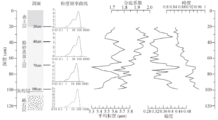 显示原图|下载原图ZIP|生成PPT
图3XDW1剖面沉积物粒度参数变化曲线
-->Fig. 3Grain size parameters of sediments in section XDW1
-->
3.3 人类遗存—细石器与灰烬层
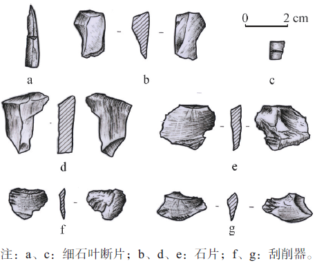
在XDW1剖面中出土有一定数量的细石器(表2,图4),在距地表20~80 cm地层中发现有3件细石叶、42件石片,51件打制石器中剥离的碎石块;这些石制品主要以黑色燧石、黑色石英砂岩为原料;这些细石器以小石片为主,多采用锤击法打片;第二次修理不普遍,多由劈裂面向背面加工,石叶制作为间接压剥法,XDW1细石器与青海其他地区和藏北地区细石器技术基本一致[3, 13]。由于XDW1剖面属于典型的原生风成沉积物,沉积物中的石制品属于史前人类活动遗留的原生堆积,未经二次搬运或改造,因此地层炭屑年代即为当时人类活动年代。Tab. 2
表2
表2XDW1剖面的石制品
Tab. 2List of stoneworks in section XDW1
| 石器数量(件) | 典型石器 | ||||||
|---|---|---|---|---|---|---|---|
| 层位(cm) | 细石叶 | 石片 | 刮削器 | 其他 | 总计 | 编号 | 描述 |
| 20~30 | 1 | 6 | 7 | XDW1-a | 细石叶,长29 mm,宽6 mm,硅质灰岩,横断面为等腰三角形,一面为劈裂面,另一面中部有凸脊,刃部有使用痕迹,尖尾端内卷 | ||
| XDW1-b | 石片,长30 mm,宽15 mm,硅质灰岩 | ||||||
| 30~40 | 7 | 1 | 8 | XDW1-d | 石片,长20 mm,宽9 mm,最厚处6 mm,燧石,一侧双面加工,形成多个锋利的刃脊,顶部刃有使用疤痕,底部横截面为三角形断面 | ||
| 40~50 | 7 | 7 | |||||
| 50~60 | 2 | 7 | 25 | 34 | XDW1-c | 细石叶断片,长8 mm,宽6 mm,硅质灰岩,横断面呈三角形,刃部有使用痕迹 | |
| 60~70 | 7 | 1 | 21 | 29 | XW1-e | 石片,呈薄片状,长23 mm,宽20 mm,最厚处4 mm,硅质灰岩 | |
| 70~80 | 5 | 2 | 7 | XW1-f | 刮削器,薄片状,长17 mm,宽13 mm,厚2 mm,燧石,两刃部锋利 | ||
| XW1-g | 石片,长23 mm,宽12 mm,燧石 | ||||||
| 80~90 | 3 | 3 | |||||
| 90~100 | 1 | 1 | |||||
新窗口打开
 显示原图|下载原图ZIP|生成PPT
图4XDW1剖面中发现的石制品
-->Fig. 4The photos of stoneworks in section XDW1
-->
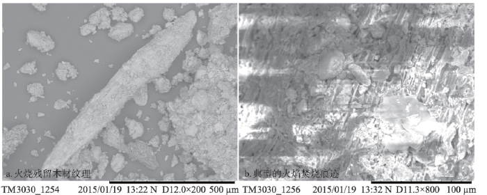
在剖面103 cm深度发现有呈水平分布的灰烬层,从揭露面积看为半径约1 m的不规则圆状,灰烬层含有较多的炭屑,大者直径1 cm多,而剖面中其他层位炭屑颗粒少而小(直径多在5 mm以下)。地层中仅在该处发现灰烬层,周围其他地点暴露的同层位未见。通过对灰烬层样品扫描电镜影像分析(图5),发现该层残留物有明显火焰焚烧痕迹,残留物图像显示有火烧后木材的纹理,并发现有火烧后灰烬的集结和结块,证明该层为利用木材燃烧后留下的灰烬层。由于灰烬层分布面积集中(如果是自然野火事件,则表现为区域性的,分布面积较广),并伴有颗粒较大的炭屑及火烧石,再加之剖面中出土细石器,推测该灰烬层与人类用火有关。对灰烬层中采集的较大炭屑(BA 131372)测年,其结果为11290±69 cal. a BP,因此,这应该是XDW1最早人类活动的年代。
 显示原图|下载原图ZIP|生成PPT
图5灰烬层扫描电镜影像
-->Fig.5The photos of ash layer in section XDW1 by scanning electron microscope (SEM)
-->
4 讨论
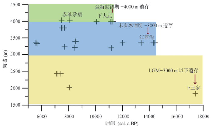
目前公开发表有测年的青藏高原旧石器—细石器遗址56个14 C年代(包括青海湖畔的江西沟[10]、黑马河[10]、晏台东[14]、铜线[14],黄河流域的下王家[17]、沙隆卡[18]、拉乙亥[19]、Yangquxi[2]、昆仑山的野牛沟[7]、通天河河畔的参雄尕塑[9],青藏高原—塔里木盆地交接带的Yangchang site[21])和8个光释光年代(包括拉萨河谷的Quesang[22]、昆仑山的西大滩[8]、青海湖畔的江西沟[2]、柴达木盆地的小柴旦湖[6])(图6)。其中Quesang的年代存在争议,本文不予讨论,从其他10余处地点的63个年代来看,本文的下大武地点是迄今青藏高原海拔4000 m左右最早的人类活动遗存,它表明早在全新世伊始的11.2 cal. ka BP人类已经在海拔4000 m的青藏高原主体与腹地活动。青藏高原东北缘及其毗邻地区石器遗址中年代较老的当属甘肃东乡下王家遗址(海拔1825 m)(图1),年代为17 cal. ka BP [17],属于末次冰盛期(Last Glacial Maximum,LGM),与冰期严酷的气候相适应,黄土高原黄土堆积,属于温带草原景观[23]。温带草原可以支撑狩猎采集经济,在甘肃庄浪县苏苗塬头也发现了LGM(24-18 cal. ka BP)的人类遗存[24],说明LGM虽然气候寒冷,但在黄土高原仍有人类活动。其时青藏高原气温较今低6~9 ℃,年均降水50~200 mm,高原西部降水低于50 mm;高原东北缘多年冻土下限较现代低1200~1400 m,高原多年冻土分布范围比现在大40%左右,高原上大部分湖泊萎缩,甚至出现原生石盐沉积,柴达木与共和盆地沙丘广布,植被以荒漠草原为主[25],严酷的自然环境应极大的限制了人类在高原的活动。
 显示原图|下载原图ZIP|生成PPT
图6青藏高原及毗邻地区旧石器—细石器遗存年代与海拔
-->Fig. 6The ages and altitudes of paleolithic-microlithic relics in Tibetan Plateau and its adjacent areas
-->
 显示原图|下载原图ZIP|生成PPT
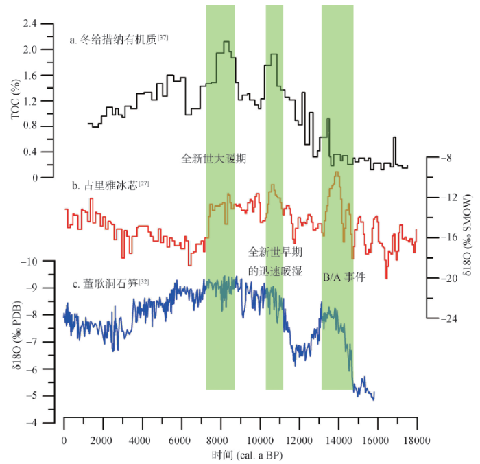
图7末次冰消期—全新世环境演变记录
-->Fig. 7The environmental evolution records from the Last Deglaciation to Holecene
-->
进入末次冰消期(16-11.5 cal. ka BP)青藏高原自然环境有较大改善,古里雅冰芯记录显示(图7):16 cal. ka BP青藏高原开始升温,在13.97 cal. ka BP达到极值,大致与欧洲的Bolling/Allerod暖事件(B/A事件)相当[26]。青海湖区在14.1cal. ka BP孢粉总浓度提高,植被由LGM时期的荒漠草原演变为疏林草原,麻黄含量下降,乔木植被主要有冷杉、云杉,零星出现桦,反映出该时段湖区植被状况较好[27]。整个高原以高寒草原—高寒草甸为主取代了LGM荒漠草原的植被面貌。地表因草原覆被使得黄土沉积变得可能,在青海湖盆地、柴达木盆地东缘均发现了此时期的风成黄土沉积[28]。另外,高原东北缘古土壤发育期主要集中在末次冰消期和全新世大暖期[29],冰消期古土壤主要发育在青海湖、共和盆地和祁连山东段;土壤类型为栗钙土,古土壤的出现指示了较温暖湿润的气候环境。在相对温暖湿润的环境条件下,人类活动出现在海拔3200 m的青海湖盆地,江西沟、黑马河和娄拉水库等为该时期的人类活动遗存,说明末次冰消期气候改善,植被恢复,已可满足人类在3000 m左右的高原东北缘狩猎活动。
11.5 cal. ka BP进入全新世,初期高原的气温与降水已经升至与现今相当[30]。董歌洞石笋记录显示,全新世之初,亚洲季风就迅速增强[31],冬给措纳湖TOC含量在全新世早期达到较大值,反映湖区生产力大大提高,古里雅冰芯氧同位素值也达到全新世的极大值;森林上限不断向高原腹地及高海拔地区延伸,以距下大武东南250 km的年宝玉则山(3300~4500 m)为例,全新世伊始,先锋灌木沿河谷发育,10.6-9.8 cal. ka BP针叶树(云杉、冷杉等)和阔叶(桦)开始扩张[32]。气温是青藏高原冰川活动的重要因素[33],位于青藏高原东南部的Queer shan的冰川活动主要集中在LGM、晚全新世和小冰期,不见全新世早期冰川活动,可以推测全新世早期,随着气温迅速升高,阿尼玛卿山区冰川迅速退缩,冰川融水的径流急剧增加,河流可能迅速下切,形成清水河河流阶地,砾石层之上堆积了全新世以来的黄土沉积。而人类就是在气温迅速升高、降水急剧增加,灌木开始蔓延,冰川退缩,径流增加的全新世伊始登上海拔4000 m的高原。很显然XDW1全新世伊始的人类活动应与环境事件紧密相关,全新世早期迅速改善的环境可能的驱动了人类向4000 m高原扩张。
8.3 cal. ka BP,年宝玉则森林植被进一步增长,标志高原进入全新世大暖期(8.3-5.9 cal. ka BP),暖期盛期出现在7.6-7.0 cal. ka BP [32],当时青藏高原气温高出现2~3 ℃ [34];降水量也较现代高,沉错湖区降水较现代高100 mm [35],Yidun湖高出现代100~120 mm[30],现今为高寒荒漠的羌塘高原及可可西里地区,在暖期盛期也发育了高山草甸[36]。全新世大暖期优越的自然条件,使得高原腹地也适宜细石器狩猎者的生存,因此在高原腹地通天河发现了8.1 cal. a BP(参雄尕塑)、昆仑山口发现了7.6 cal. a BP(野牛沟)等人类遗存,甚至在现今无人区的可可西里也有不少细石器的遗存,推测应该是全新世大暖期盛期时的产物。在青藏高原与塔里木盆地交接地带的昆仑山北麓克里雅河出山口,也发现7.6-7.0 cal. ka BP细石器遗存[21]。
因此,人类向青藏高原扩张历程大致明了:LGM已有人类在海拔3000 m以下的黄土高原活动,末次冰消期的15-13 cal. ka BP人类在海拔3000 m的高原东北缘青海湖、共和盆地等活动,全新世早期人类便扩张至海拔4000 m的青藏高原主体,全新世大暖期盛期人类活动进一步向高原腹地深入。不难发现,从末次冰消期开始,人类活动逐渐从低海拔向高海拔,从东向西,从高原边缘向腹地不断扩张,在全新世暖期盛期人类活动的足迹已深入高原腹地。XDW1是目前青藏高原海拔4000 m区域发现最早的人类活动遗存之一,其恰好处在青藏高原海拔4000 m主体的边缘,是3000 m向4000 m区域过渡及深入高原腹地的重要地带,也是人类向高原内部扩张的关键一环。
5 结论
XDW1号剖面属于典型的风成黄土沉积,时间为全新世早期,年代主要集中在11.2 cal. ka BP。在地层103 cm处发现有人类活动遗留的灰烬层,并伴有细石叶、石片等石制品,灰烬层年代为11290±69 cal. a BP,这是目前青藏高原海拔4000 m区域发现的最早的人类活动证据之一,同时探讨了人类在青藏高原东北缘扩张的扩张历程,即末次冰消期人类开始在高原东北缘海拔3000 m左右的区域活动,全新世初期即已登上4000 m主体,全新世大暖期向高原腹地进一步扩张。致谢:兰州大学董广辉、张东菊博士,德国柏林自由大学晏达达博士,南京师范大学汤惠生教授,青海省考古所王倩倩副研究员提供帮助,青海师范大学常华进博士鉴定了石器岩性,袁杰、王建同学参加野外采样。
The authors have declared that no competing interests exist.
参考文献 原文顺序
文献年度倒序
文中引用次数倒序
被引期刊影响因子
| [1] | Study of human adaptation to extreme environments is important for understanding our cultural and genetic capacity for survival. The Pucuncho Basin in the southern Peruvian Andes contains the highest-altitude Pleistocene archaeological sites yet identified in the world, about 900 meters above confidently dated contemporary sites. The Pucuncho workshop site [4355 meters above sea level (masl)] includes two fishtail projectile points, which date to about 12.8 to 11.5 thousand years ago (ka). Cuncaicha rock shelter (4480 masl) has a robust, well-preserved, and well-dated occupation sequence spanning the past 12.4 thousand years (ky), with 21 dates older than 11.5 ka. Our results demonstrate that despite cold temperatures and low-oxygen conditions, hunter-gatherers colonized extreme high-altitude Andean environments in the Terminal Pleistocene, within about 2 ky of the initial entry of humans to South America. |
| [2] | |
| [3] | 青藏高原一直是中国旧石器和细石器考古所关注和颇有争议的地区之一。其原因首先在于80年代以前这个地区所发现的石器地点很少,且多无地层关系,故其时代和文化性质很难确定;其次由于这个地区独特的自然地理环境,即作为一个世界上最年轻的高原,其地质、地貌和气候等均 青藏高原一直是中国旧石器和细石器考古所关注和颇有争议的地区之一。其原因首先在于80年代以前这个地区所发现的石器地点很少,且多无地层关系,故其时代和文化性质很难确定;其次由于这个地区独特的自然地理环境,即作为一个世界上最年轻的高原,其地质、地貌和气候等均 |
| [4] | |
| [5] | |
| [6] | |
| [7] | In 2009, a new microlithic site in the Yeniugou Valley, in the vicinity of the entrance to the northern Qingzang Plateau in the Kunlun Mountains of Qinghai province, was discovered by archaeologists. This study has been published on (In Chinese), 2013, No.3. |
| [8] | ABSTRACT 10 Be-26 Al cosmogenic surface exposure, optically stimulated luminescence, and radiocarbon dates from the site of Xidatan 2 (鈭4300 m above sea level [asl] in the Kunlun Pass, northern Tibetan Plateau) suggest the site was in-termittently and briefly occupied approximately 9200–6400 yr B.P. This age is substantially younger than expected given the late Upper Paleolithic character of the lithic assemblage, which is dominated by microlithic and unique dis-coidal prepared core technologies. Comparisons between Xidatan 2 and known surface lithic assemblages in the Kekexili and Chang Tang regions of the central high Plateau show not only that the latter are technologically similar to Xidatan 2, but also that they are demonstrably connected to Xidatan 2 through utiliza-tion of the same stone raw materials, which includes a chemically distinctive obsidian. Contrary to most accounts of Tibetan Plateau colonization, our re-sults suggest that the earliest substantial occupations on the interior Tibetan Plateau above 4000 m asl may date to the Pleistocene/Holocene transition. C 2013 Wiley Periodicals, Inc. |
| [9] | |
| [10] | The pre-Neolithic history of the Tibetan Plateau is virtually unknown. Test excavations of Late Paleolithic sites, described here, provide preliminary evidence that the initial occupation of the plateau's extreme environments was by small groups of foragers probably traveling from lower elevation plateau margins. These foragers occupied very short-term camps focused on the procurement and extensive processing of small-to-medium mammals. Five separate occupations date to 13-15,000 Cal yr BP, but limited survey data suggest mid-elevation locations may have been temporarily occupied as early as 25,000 years ago. Full-time, year-round occupation of the plateau probably did not take place until the early Neolithic advent of domesticated animals. (c) 2006 Elsevier Ltd. All rights reserved. |
| [11] | Transitions from terminal Pleistocene Upper Paleolithic foraging to Holocene Neolithic farming and pastoralist economic orientations in the northern Tibetan Plateau are examined from the perspective of Epipaleolithic sites located near Qinghai Lake, Qinghai Province, western China. Jiangxigou 2 is an artifact-rich, multicomponent midden site with the main period of occupation dating ca. 9000鈥5000 cal yr BP, containing abundant flaked stone artifacts including a substantial proportion of microlithic tools, abundant faunal remains including gazelle, deer, and sheep, and a small number of ceramics, including the oldest known on the Tibetan Plateau. Heimahe 3, on the other hand, is a brief hunter's camp dating ca. 8450 cal yr BP, with evident affinities to late Upper Paleolithic camps in the same region that date several thousand years older. The two distinctively different sites are probably nodes within a single Epipaleolithic foraging system that developed on the margins of the high Tibetan Plateau during the early Holocene, and that served as a basis for colonization of the high-altitude Plateau at that time. Jiangxigou 2 appears to be connected to early Neolithic agricultural settlements along the upper Yellow River (Huang He) drainage during the middle Holocene, and may provide insights into forager鈥揳griculturalist interactions that lead to the development of pastoralist systems in the region. |
| [12] | Archeological research over the past several years has started to provide evidence relevant to understanding both the timing of and processes responsible for human colonization of the Tibetan Plateau. This harsh, high-elevation environment is known to exact a heavy demographic toll on recent migrants, and such costs likely erected a substantial biogeographic barrier to initial human colonization. This chapter presents a series of simple metapopulation models that link processes of colonization to mutually exclusive archeological predictions. Current archeological evidence from the northern Tibetan Plateau suggests that seasonal forays into high elevation settings were “adaptive radiations” coincident with the appearance of both Early (ca. 30ka) and Late Upper Paleolithic (ca. 15ka) adaptations in low-elevation source areas around the Plateau. More permanent occupation of the Plateau probably did not begin before ca. 8200ka and may have been driven by “competitive exclusion” of Late Upper Paleolithic foragers from low-elevation environments by emerging settled agricultural groups. The appearance of specialized epi-Paleolithic blade and bladelet technologies on the high Plateau, after 8200ka, may indicate “directional selection” impacting these new full-time residents. An adaptive radiation of agriculturalists into the mid-elevations of the Plateau, this time leading to year-round occupation, is again seen after 6000 Cal yr BP. The short chronology presented here contradicts genetic-based models suggesting that human populations may have been resident on the Tibetan Plateau for as long as 30,000 years. If the short chronology withstands further empirical scrutiny, it suggests either that initial colonists were genetically predisposed to the rapid accumulation of mutations leading to successful physiological adaptation, or that high-elevation selective pressures are much more severe than usually conceived. |
| [13] | 自20世纪80年代在青海小柴 旦发现旧石器遗存以来,青藏高原边缘地区已经发现了10余处旧石器时代遗址,年代属晚更新世晚期。这些遗存显示,古人类在距今30ka左右开始尝试向这些 高海拔地区扩散,但直至距今15ka以后才有更多的人群迁徙至此。通过对这些遗存分布位置、古环境特征、年代测定和石器技术、组合分析,得以管窥古人类对 该地区的开发利用过程,并进而阐释史前人类技术发展、生存模式演变和古环境的耦合关系。 . 自20世纪80年代在青海小柴 旦发现旧石器遗存以来,青藏高原边缘地区已经发现了10余处旧石器时代遗址,年代属晚更新世晚期。这些遗存显示,古人类在距今30ka左右开始尝试向这些 高海拔地区扩散,但直至距今15ka以后才有更多的人群迁徙至此。通过对这些遗存分布位置、古环境特征、年代测定和石器技术、组合分析,得以管窥古人类对 该地区的开发利用过程,并进而阐释史前人类技术发展、生存模式演变和古环境的耦合关系。 |
| [14] | 2009年6月-7月,在青藏高原边缘地区调查、试掘了6处遗 址,获得一批石制品、动物骨骼残片、火塘等材料.石制品多数个体较小,类型包括石核、石片、工具、断块、细石核、细石叶等.通过对比出土材料及部分遗址测 年数据判断,6处遗址的年代处于13ka BP左右的晚更新世至全新世.此次调查试掘,丰富了该区域人类活动的证据,对研究青藏高原环境变化、古人类的适应生存过程及技术交流有一定意义. . 2009年6月-7月,在青藏高原边缘地区调查、试掘了6处遗 址,获得一批石制品、动物骨骼残片、火塘等材料.石制品多数个体较小,类型包括石核、石片、工具、断块、细石核、细石叶等.通过对比出土材料及部分遗址测 年数据判断,6处遗址的年代处于13ka BP左右的晚更新世至全新世.此次调查试掘,丰富了该区域人类活动的证据,对研究青藏高原环境变化、古人类的适应生存过程及技术交流有一定意义. |
| [15] | |
| [16] | |
| [17] | . |
| [18] | We report an investigation of forty-two prehistoric sites in the upper Yellow River valley located in Guide, Jianzha, Hualong, Xunha and Minhe, Qinghai Province, China, including forty-four new radiocarbon dates from twenty-four sites, review published archaeological surveys and radio-carbon dates, analyze landform features and discuss the reasons for spatial and temporal variety of regional prehistoric human settlement. Our results suggest that people occupied the upper Yellow River valley during the early Holocene, but a continuous archaeological record begins only after about 5500 Cal yr BP. Thereafter, the intensity of prehistoric human settlement in the area is varied. Neolithic human settlement spread northwestward to high altitude areas of the upper Yellow River valley during early-mid Majiayao and Qijia periods, but moved southeastward to lower locations in the area during late Majiayao period. During the Bronze period, two coeval archaeological cultures, the Kayue and Xindian, occupied the upper Yellow River Region. Kayue archaeological sites are numerous and widely distributed in the high areas of the upper Yellow River, while Xindian sites are restricted to the lowest basin of the region. Variation in site density and location are likely the result of changing paleoclimate and technology. (C) 2012 Elsevier Ltd. All rights reserved. |
| [19] | 利用动物骨骼,测得拉乙亥遗址的C 14 年代为距今6745±85年,接近中原地区的新石器时代遗址的时代。但是,在出土的文化遗物中,未发现陶器和磨光石器等新石器时代的典型标志,而且遗址埋藏于较高阶地的堆积物中,发现的大量打制石器与华北旧石器时代晚期的石制品非常相似。这个遗址的发现为研究西北地区的文化发展史提出了新的问题。 . 利用动物骨骼,测得拉乙亥遗址的C 14 年代为距今6745±85年,接近中原地区的新石器时代遗址的时代。但是,在出土的文化遗物中,未发现陶器和磨光石器等新石器时代的典型标志,而且遗址埋藏于较高阶地的堆积物中,发现的大量打制石器与华北旧石器时代晚期的石制品非常相似。这个遗址的发现为研究西北地区的文化发展史提出了新的问题。 |
| [20] | |
| [21] | The routes and timing of human occupation of the Tibetan Plateau (TP) are crucial for understanding the evolution of Tibetan populations and associated paleoclimatic conditions. Many archeological sites have been found in/around the Tarim Basin, on the northern margin of the Tibetan Plateau. Unfortunately, most of these sites are surface sites and cannot be directly dated. Their ages can only be estimated based on imprecise artifact comparisons. We recently found and dated an archeological site on a terrace along the Kenya River. Outages indicate that the site was occupied at similar to 7.0-7.6 ka, making it the earliest well-dated archeological site yet identified in the Tarim Basin. This suggests that early human foragers migrated into this region prior to similar to 7.0-7.6 ka during the early to mid-Holocene climatic optimum, which may have provided the impetus for populating the region. We hypothesize that the Kenya River, together with the other rivers originating from the TP, may have served as access routes onto the TP for early human foragers. These rivers may also have served as stepping stones for migration further west into the now hyper-arid regions of the Tarim Basin, leading ultimately to the development of the Silk Road. (C) 2014 University of Washington. Published by Elsevier Inc. All rights reserved. |
| [22] | |
| [23] | 根据130ka BP以来东部沙区的地质记录,将本区古季风划分为末次间冰期(130~70kaBP)夏季风为主时期、末次冰期(70~10kaBP)冬季风为主时期和冰 后期(10kaBP至今)夏季风为主的不稳定时期3个演化时期,以及末次间冰期(120ka BP和100~95kaBP)冬季风增强期、末次冰期(59~21kaBP)夏季风增强期、冰后期早全新世(10~7.5kaBP)夏季风增强期、中全新 世(7.5~4kaBP)夏季风鼎盛期和晚全新世(4kaBP至今)夏季风衰弱期等若干阶段。冬、夏季风的转换以突变为主。夏季风北界位置从末次间冰期的 马鬃山-乌兰巴托退至末次冰期的黄土高原砂黄土带北界附近,复又进到全新世最佳期的山丹-雅布赖山一带,最后退到现代阴山北麓-呼伦贝尔一线,反映东亚季 风环流的夏季风呈现波动减弱的趋势。影响季风变迁的因素复杂,特别是全新世期间的短周期波动应加强研究。 . 根据130ka BP以来东部沙区的地质记录,将本区古季风划分为末次间冰期(130~70kaBP)夏季风为主时期、末次冰期(70~10kaBP)冬季风为主时期和冰 后期(10kaBP至今)夏季风为主的不稳定时期3个演化时期,以及末次间冰期(120ka BP和100~95kaBP)冬季风增强期、末次冰期(59~21kaBP)夏季风增强期、冰后期早全新世(10~7.5kaBP)夏季风增强期、中全新 世(7.5~4kaBP)夏季风鼎盛期和晚全新世(4kaBP至今)夏季风衰弱期等若干阶段。冬、夏季风的转换以突变为主。夏季风北界位置从末次间冰期的 马鬃山-乌兰巴托退至末次冰期的黄土高原砂黄土带北界附近,复又进到全新世最佳期的山丹-雅布赖山一带,最后退到现代阴山北麓-呼伦贝尔一线,反映东亚季 风环流的夏季风呈现波动减弱的趋势。影响季风变迁的因素复杂,特别是全新世期间的短周期波动应加强研究。 |
| [24] | 苏苗塬头地点位于甘肃省平凉市庄浪县东北部,埋藏于章麻河二级阶地的典型马兰黄土中。经剖面 清理和地表采集,2002和2004年在该地点共获得石制品2318件,本文以集中分布区出土(2166件)和地表采集(48件)共2214件石制品为主 要研究对象。该批石制品以石片、碎片和碎屑为主,有少量石核和工具。剥片技术以砸击法为主,锤击法为辅,鲜见第二步加工。石制品原料主要为来自现代河床或 阶地底部砾石层的脉石英。炭屑加速器质谱(AMS 14C)年代测试和多环境代用指标分析显示,苏苗塬头为一处旧石器时代晚期文化地点,人类活动主要发生于气候干冷的末次盛冰期(约距今2.4—1.8万 年),反映了古人类较强的环境适应能力。 . 苏苗塬头地点位于甘肃省平凉市庄浪县东北部,埋藏于章麻河二级阶地的典型马兰黄土中。经剖面 清理和地表采集,2002和2004年在该地点共获得石制品2318件,本文以集中分布区出土(2166件)和地表采集(48件)共2214件石制品为主 要研究对象。该批石制品以石片、碎片和碎屑为主,有少量石核和工具。剥片技术以砸击法为主,锤击法为辅,鲜见第二步加工。石制品原料主要为来自现代河床或 阶地底部砾石层的脉石英。炭屑加速器质谱(AMS 14C)年代测试和多环境代用指标分析显示,苏苗塬头为一处旧石器时代晚期文化地点,人类活动主要发生于气候干冷的末次盛冰期(约距今2.4—1.8万 年),反映了古人类较强的环境适应能力。 |
| [25] | 在16~32kaBP的末次冰 期最盛时,青藏高原较现代降温7℃左右,降水为现代的30%~70%。极地型冰川广泛分布,高原内部平衡线较现代下降值减至500~300m以内,高原东 部、南缘及西缘可能以亚极地型冰川为主,并有小部分温冰川,平衡线下降800m以至1000~1200m。初步统计,包括周围高山在内冰川面积在 35×104km2左右,为现代冰川的7.5倍,冰储量相当于全球海平面变化24.2cm。其时,多年冻土分布范围亦大为发展,面积达 220×104km2。海拔较低处季风降水量影响强烈的湖泊出现低水位或接近于干枯,海拔较高处季风影响微弱的高原中西部湖泊呈现低于间冰段、高于冰后期 的次高水位,湖水含盐量普遍增加,柴达木出现多层石盐沉积。荒漠草原扩大,占领了高原大部分地面,森林退缩至高原东南缘狭长范围内 . 在16~32kaBP的末次冰 期最盛时,青藏高原较现代降温7℃左右,降水为现代的30%~70%。极地型冰川广泛分布,高原内部平衡线较现代下降值减至500~300m以内,高原东 部、南缘及西缘可能以亚极地型冰川为主,并有小部分温冰川,平衡线下降800m以至1000~1200m。初步统计,包括周围高山在内冰川面积在 35×104km2左右,为现代冰川的7.5倍,冰储量相当于全球海平面变化24.2cm。其时,多年冻土分布范围亦大为发展,面积达 220×104km2。海拔较低处季风降水量影响强烈的湖泊出现低水位或接近于干枯,海拔较高处季风影响微弱的高原中西部湖泊呈现低于间冰段、高于冰后期 的次高水位,湖水含盐量普遍增加,柴达木出现多层石盐沉积。荒漠草原扩大,占领了高原大部分地面,森林退缩至高原东南缘狭长范围内 |
| [26] | An ice core record from the Guliya ice cap on the Qinghai-Tibetan Plateau provides evidence of regional climatic conditions over the last glacial cycle. Cl data suggest that the deepest 20 meters of the core may be more than 500,000 years old. The δO change across Termination I is 655.4 per mil, similar to that in the Huascarán (Peru) and polar ice cores. Three Guliya interstadials (Stages 3, 5a, and 5c) are marked by increases in δO values similar to that of the Holocene and Eemian (65124,000 years ago). The similarity of this pattern to that of CHrecords from polar ice cores indicates that global CHlevels and the tropical hydrological cycle are linked. The Late Glacial Stage record contains numerous 200-year oscillations in δO values and in dust, NH, and NOlevels. |
| [27] | Multi-proxy analysis of a sediment core from Qinghai Lake, including pollen, carbonate, TOC, TN and δ 13 C of organic matter, was used to document regional climatic changes during the last 18,000 years. Climate was very cold and dry before 16.902cal.02kyr02BP. The warm and wet period, which began at about 14.102cal.02kyr02BP, culminated at 6.502cal.02kyr02BP and came to its end at about 4.502cal.02kyr02BP. After that, the climate gradually became colder and drier. During the transitional period from the Late Glacial to the Holocene the climate fluctuated frequently. The short-term climatic oscillations, including the B03lling, Aller02d, Younger Dryas and the cooling event at ca. 8.202cal.02kyr02BP, appear to be recorded in the Qinghai Lake sedimentary record. The climatic evolution in the Qinghai Lake area during the past 18,000 years indicates that solar insolation changes on the ten-thousand-year scale are the likely driving force of the East-Asia monsoon. |
| [28] | . Aeolian sediments are widely distributed in the hyper-arid Qaidam Basin and are good palaeoclimatic records. Due to limited age control, aeolian processes and their relevance to palaeoclimatic change are poorly understood. In this study, we present 28 optically stimulated luminescence (OSL) ages for both loess (14 samples) and aeolian sand (14 samples) from 8 profiles in eastern Qaidam Basin (EQB) in order to provide a detailed chronology for understanding the timing of aeolian processes and associated environmental conditions. We reconstructed the history of aeolian activity in the EQB since deglaciation by combining OSL chronologies, lithologic stratigraphy and grain-size analysis. The results indicate that (1) aeolian sand underlying the loess accumulated at ca. 12.4–11.502ka and 10–802ka, but not during the Last Glacial Maximum, (2) loess accumulation started at 1002ka and lasted to 0.4502ka at least, while most of the loess was deposited during 8–4.502ka, (3) palaeoclimates in the EQB are inferred to be arid during 12.4–11.502ka, (relatively) humid during 10–802ka, humid during 8–4.502ka and relatively arid during 4.5–0.4502ka, and (4) evolution of aeolian sediments were mainly controlled by effective moisture, and also affected by local topography. |
| [29] | . |
| [30] | Canonical correspondence analysis (CCA) was used to reveal the climatic parameters that best reflect the main patterns of variation in the modern pollen rain, and to detect anomalous observations. Results of CCA indicate that MAP and T july are two climatic parameters controlling the variation of modern pollen rain in the Tibetan Plateau. Pollen–climate transfer functions for MAP and T july were then developed using the inverse linear regression and weighted-averaging partial least squares regression models. The functions derived from these two models are statistically significant at the 0.0000 level. A case study, in which these functions were applied to a fossil pollen record from an alpine lake in the eastern Tibetan Plateau, was conducted to show the feasibility of these functions in paleoclimate reconstruction. The results demonstrated the applicability of these pollen–climate transfer functions to fossil pollen data. |
| [31] | Previous work on speleothems from Hulu Cave, China, demonstrated a link between last glacial period and deglacial East Asian monsoon intensity and millennial-scale events in the North Atlantic as well as orbitally induced insolation variations (Wang et al., 2001, Science, 294, 2345-2348). The East Asian monsoon originates from the tropical Pacific thereby connecting this specific site in the tropics to the processes creating these millennial-scale events. Recently these events have been observed to extend into the Holocene (Bond et al., 2001, Science, 278, 1257-1266), challenging the idea of fairly stable climatic conditions observed in Greenland ice cores during the Holocene. Here we present a continuous record of the Asian monsoon over the last 16,000 years from stalagmite calcite to further extend the link between Asian monsoon intensity and millennial-scale events into the Holocene. This time range overlaps the Hulu stalagmites by 006,000 years and a strong correlation is observed between the two records suggesting the same mechanisms affecting the East Asian monsoon affect a broader region of the Asian monsoon system. 808 oxygen isotopic measurements providing information on shifts in monsoon precipitation are combined with a chronology from 45 precise Th dates. Monsoon intensity increased dramatically ( 003‰ ) during the start of the Holocene ( 0011.5 ka) and remained high for 006 ka. In the middle-late Holocene, two abrupt positive shifts in δ O occur at 5457+/-75 years (0.75‰ in 170 y) and 3614+/-50 years (1.1‰ in 15 y) corresponding to a stepwise decrease in Asian monsoon intensity at these times. In addition, several other smaller intervals of decreased Asian monsoon activity occur suggesting millennial-scale features are present in the Holocene. Whereas one period of decreased activity occurs at 8085 years BP within error of the "8200-year event" seen in Greenland ice cores, similar events ( 001.1‰ ) are present throughout the record. Therefore the "8200 year event" is not clearly evident in the monsoon record. Spectral analyses of the δ O record show significant peaks at 205- and 88- year cycles, which are also present in records of solar activity (Stuiver and Braziunas, 1993, Holocene, 3, 289-305), suggesting monsoon variation is influenced by solar forcing. However, there are numerous significant peaks at periods not present in the solar spectra. Thus, there are additional features besides insolation and solar variations, which affect the Asian monsoon. |
| [32] | |
| [33] | It is highly debated whether glacial advances on the Qinghai鈥揟ibetan Plateau (QTP) occurred as a response to temperature cooling, or whether they were forced by an increase in moisture brought by the intensive Indian summer monsoon. We here report a case study investigating this issue. Multiple moraine series in the Yingpu Valley, Queer Shan ranges of the Hengduan Mountains, and eastern QTP, provide an excellent archive for examining the timing and trigger mechanism of glacier fluctuations. Twenty-seven optically stimulated luminescence (OSL) samples of glacial sediments were collected from this valley. The quartz OSL ages show that the moraine series of Y-1, I, M and O were formed during the Late Holocene, Late Glacial, the global Last Glacial Maximum (LGM) and Marine Oxygen Isotope Stage (MIS) 3 (likely mid-MIS-3). The youngest Y-2 moraines probably formed during the Little Ice Age (LIA). The oldest H moraines formed before MIS-3. We found that glacial advances during the late Quaternary at the Yingpu Valley responded to cold stages or cold events rather than episodes of enhanced summer monsoon and moisture. As a result, glaciers in the monsoonal Hengduan Mountains were mainly triggered by changes in temperature. Millennial time scale temperature oscillations might have caused the multiple glacial advances. |
| [34] | 按照气温变化规律将中国气温变化划分为东北、华北北部、华东华南、华南、陕甘宁、川黔桂、新疆和滇藏高原区等8个分区。搜集有确切年代和气温数值的古气温记录1397条,以8个分区为单元进行整理,以日历年时间为坐标系,采用单样本区域订正—多样本平均集成法重建了东北、华北北部、华东华南、华南和滇藏高原区的全新世200 a分辨率连续集成气温序列。结果表明:5条分区连续气温序列与所在区域的高分辨率环境记录变化趋势基本一致,主要的百年尺度冷暖事件有较高的可比性;5条分区连续序列指示全新世气温变化可以分为明显的早期升温、中期大暖期和晚期变冷3个阶段;气温变化幅度区域差异较大,但主要的冷暖事件基本一致,暖期盛期发生在8~6 ka BP,当时滇藏高原约比现代高2℃,东北高出3℃,华北北部高1.5℃,华东华南接近1℃,华南区仅高出0.5℃;主要冷事件发生在9.2、6.2、4.0和0.4 ka BP,其中,4.0 ka BP冷事件规模较大,滇藏高原、东北、华北北部、华东华南和华南区降低幅度分别为1.5、2、1、0.5和0.5℃。全新世期间各分区气温变化幅度也表现出纬度从北向南、海拔从高到低、气温变化幅度依次递减的特征。 . 按照气温变化规律将中国气温变化划分为东北、华北北部、华东华南、华南、陕甘宁、川黔桂、新疆和滇藏高原区等8个分区。搜集有确切年代和气温数值的古气温记录1397条,以8个分区为单元进行整理,以日历年时间为坐标系,采用单样本区域订正—多样本平均集成法重建了东北、华北北部、华东华南、华南和滇藏高原区的全新世200 a分辨率连续集成气温序列。结果表明:5条分区连续气温序列与所在区域的高分辨率环境记录变化趋势基本一致,主要的百年尺度冷暖事件有较高的可比性;5条分区连续序列指示全新世气温变化可以分为明显的早期升温、中期大暖期和晚期变冷3个阶段;气温变化幅度区域差异较大,但主要的冷暖事件基本一致,暖期盛期发生在8~6 ka BP,当时滇藏高原约比现代高2℃,东北高出3℃,华北北部高1.5℃,华东华南接近1℃,华南区仅高出0.5℃;主要冷事件发生在9.2、6.2、4.0和0.4 ka BP,其中,4.0 ka BP冷事件规模较大,滇藏高原、东北、华北北部、华东华南和华南区降低幅度分别为1.5、2、1、0.5和0.5℃。全新世期间各分区气温变化幅度也表现出纬度从北向南、海拔从高到低、气温变化幅度依次递减的特征。 |
| [35] | |
| [36] | Abstract Pollen data from China for 6000 and 18,00002C02yr02bpwere compiled and used to reconstruct palaeovegetation patterns, using complete taxon lists where possible and a biomization procedure that entailed the assignment of 645 pollen taxa to plant functional types. A set of 658 modern pollen samples spanning all biomes and regions provided a comprehensive test for this procedure and showed convincing agreement between reconstructed biomes and present natural vegetation types, both geographically and in terms of the elevation gradients in mountain regions of north-eastern and south-western China. The 600002C02yr02bpmap confirms earlier studies in showing that the forest biomes in eastern China were systematically shifted northwards and extended westwards during the mid-Holocene. Tropical rain forest occurred on mainland China at sites characterized today by either tropical seasonal or broadleaved evergreen/warm mixed forest. Broadleaved evergreen/warm mixed forest occurred further north than today, and at higher elevation sites within the modern latitudinal range of this biome. The northern limit of temperate deciduous forest was shifted 0280002km north relative to today. The 18,00002C02yr02bpmap shows that steppe and even desert vegetation extended to the modern coast of eastern China at the last glacial maximum, replacing today’s temperate deciduous forest. Tropical forests were excluded from China and broadleaved evergreen/warm mixed forest had retreated to tropical latitudes, while taiga extended southwards to .0243°N. |
| [37] | .Palaeogeography, Palaeoclimatology,Palaeoecology, Organic geochemical proxy data from surface sediment samples and a sediment core from Lake Donggi Cona were used to infer environmental changes on the northeastern Tibetan Plateau spanning the last 18.4kyr. Long-chain n-alkanes dominate the aliphatic hydrocarbon fraction of the sediment extract from most surface sediment samples and the sediment core. Unsaturated mid-chain n-alkanes (nC 23:1 and nC 25:1) have high abundances in some samples, especially in core samples from the late glacial and early Holocene. TOC contents, organic biomarker and non-pollen-palynomorph concentrations and results from organic petrologic analysis on selected samples suggest three major episodes in the history of Lake Donggi Cona. Before ca. 12.6calka BP samples contain low amounts of organic matter due to cold and arid conditions during the late glacial. After 12.6calka BP, relatively high contents of TOC and concentrations of Botryococcus fossils, as well as enhanced concentrations of mid-chain n-alkanes and n-alkenes suggest a higher primary and macrophyte productivity than at present. This is supported by high contents of palynomorphs derived from higher plants and algae and was possibly triggered by a decrease of salinity and amelioration of climate during the early Holocene. Since 6.8calka BP Lake Donggi Cona has been an oligotrophic freshwater lake. Proxy data suggest that variations in insolation drive ecological changes in the lake, with increased aquatic productivity during the early Holocene summer insolation maximum. Short-term drops of TOC contents or biomarker concentrations (at 9.9calka BP, after 8.0 and between 3.5 and 1.7calka BP) can possibly be related to relatively cool and dry episodes reported from other sites on the north-eastern Tibetan Plateau, which are hypothesized to occur in phase with Northern Hemisphere cooling events. 漏 2011 Elsevier B.V. |
