张晓龙1,
李红军1,
沈彦军1, 2,,
1.中国科学院遗传与发育生物学研究所农业资源研究中心/中国科学院农业水资源重点实验室/河北省节水农业重点实验室 石家庄 050022
2.中国科学院大学 北京 100049
基金项目: 国家自然科学基金项目41807177
国家自然科学基金项目42001037
国家自然科学基金项目41971262
详细信息
作者简介:石嘉丽, 主要从事生态水文模拟方面的研究。E-mail: shijiali19@mails.ucas.ac.cn
通讯作者:沈彦军, 主要从事流域生态水文模拟与水环境管理方面的研究。E-mail: shenyanjun@sjziam.ac.cn
中图分类号:P426.2计量
文章访问数:51
HTML全文浏览量:13
PDF下载量:16
被引次数:0
出版历程
收稿日期:2020-10-10
录用日期:2020-12-29
网络出版日期:2021-06-22
刊出日期:2021-06-01
Spatial-temporal changes in green water and its driving factors in the Bashang area of Hebei Province
SHI Jiali1, 2,,ZHANG Xiaolong1,
LI Hongjun1,
SHEN Yanjun1, 2,,
1. Center for Agricultural Resources Research, Institute of Genetics and Developmental Biology, Chinese Academy of Sciences/Key Laboratory of Agricultural Water Resources, Chinese Academy of Sciences/Hebei Key Laboratory of Water-saving Agriculture, Shijiazhuang 050022, China
2. University of Chinese Academy of Sciences, Beijing 100049, China
Funds: the National Natural Science Foundation of China41807177
the National Natural Science Foundation of China42001037
the National Natural Science Foundation of China41971262
More Information
Corresponding author:SHEN Yanjun, E-mail: shenyanjun@sjziam.ac.cn
摘要
HTML全文
图
参考文献
相关文章
施引文献
资源附件
访问统计
摘要
摘要:河北坝上半干旱农牧交错带是首都西北重要的生态屏障。绿水在维持坝上半干旱生态系统稳定、保障京津冀地区生态环境安全中发挥着重要作用,但绿水资源的时空分布及其驱动因素还缺乏定量理解。本文基于GLASS蒸散产品,定量分析了2001—2015年河北坝上(康保县、沽源县、尚义县、张北县)县域尺度的绿水时空变化特征,通过线性变化系数、相关系数、贡献率方法评估了绿水变化对气温、降水、净辐射(Rn)、总第一性生产力(GPP)以及土地利用的响应规律,以期为坝上地区“首都水源涵养功能区和生态环境支撑区”建设、水资源高效利用提供科学依据。研究结果表明:1)2001—2015年坝上4县的绿水量总体呈下降趋势,多年平均绿水量为371.11 mm;绿水量季节变化明显,表现为夏季>春季>秋季>冬季。2)绿水量由西北至东南递增,其中沽源县绿水量最大,康保县绿水量最小;研究期间21.2%的区域绿水量呈增加趋势,78.8%的区域呈减少趋势。3)绿水与降水、GPP呈正相关关系,与气温和净辐射呈负相关关系,各影响因子对绿水变化的贡献率排序为GPP >气温>降水> Rn,GPP的贡献率高达51%。4)研究区内各土地利用类型绿水量表现为林地>草地>耕地>建设用地。绿水量变化趋势受土地利用变化影响显著,土地利用更直接地影响绿水的空间分布。
关键词:绿水/
蒸散/
气候因素/
总第一性生产力(GPP)/
土地利用/
河北坝上
Abstract:The Bashang area is a semi-arid farming-pastoral zone in Hebei Province and represents an important ecological barrier northwest of the capital. Green water plays an important role in maintaining the stability of the semi-arid ecosystem in Bashang and ensuring the safety of the ecological environment in the Beijing-Tianjin-Hebei region. However, a quantitative understanding of the temporal and spatial distribution of green water in this area and underlying driving factors is lacking. This study used Global Land Surface Satellite (GLASS) evapotranspiration products to quantitatively analyze the spatio-temporal changes in green water and evaluated the effect on changes in green water of temperature, precipitation, net radiation (Rn), gross primary productivity (GPP), and land use at the county level (Kangbao, Guyuan, Shangyi, and Zhangbei Counties) from 2001 to 2015. These results provide a scientific basis for the construction of the "Capital Water Conservation Functional Zone and Ecological Environment Support Zone" and more efficient use of the water resources in the Bashang area. This study used the linear trend method to assess the changing trends of green water, and based on the pixel and correlation coefficient methods to analyze the driving factors of green water variation. Multiple regression analysis was used to calculate the contribution rate of each driving factor. The results showed that: 1) the amount of green water in the four counties showed an overall insignificant downward trend from 2001 to 2015. The maximum value was in 2003 (415.34 mm), and the minimum value was in 2009 (322.35 mm). The annual average green water amount was 371.11 mm. The seasonal variation of green water amount was obvious. Summer had the highest amount of green water, followed by spring, autumn, and winter. 2) The amount of green water increased from northwest to southeast regions, most of which showed a decreasing trend. Guyuan County had the highest amount of green water, and Kangbao County had the least amount. Across the regions, 21.2% showed an increasing trend in the volume changes of green water, and 78.8% of the regions showed a decreasing trend from 2001 to 2015. 3) From 2001 to 2015, the precipitation, temperature, and GPP showed an overall increasing trend, whereas Rn showed an insignificant downward trend. Green water was positively correlated with precipitation and GPP and negatively correlated with temperature and Rn. The contribution rate of each influencing factor was in the following order: GPP > temperature > precipitation > Rn. The GPP contribution rate was as high as 51%. The above-mentioned factors primarily affected temporal changes in green water. 4) The highest amount of green water was in the forest land, followed by grassland, cultivated land, construction land, and unused land. There were no significant differences in the amount of green water among land-use types, but the trend of green water changes was significantly affected by land-use changes. Land use directly affected the spatial distribution of green water.
Key words:Green water/
Evapotranspiration/
Climate factors/
Gross Primary Productivity (GPP)/
Land use/
Bashang area of Hebei Province
HTML全文
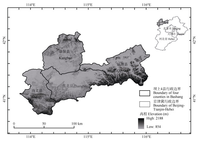
图1张家口市坝上4县研究区地理位置
Figure1.Location of the study area of the four counties of Zhangjiakou in Bashang area
 下载: 全尺寸图片幻灯片
图22001—2015年张家口市坝上4县绿水量年际变化趋势图
Figure2.Annual variation of green water of the four counties of Zhangjiakou in Bashang area during 2001?2015
下载: 全尺寸图片幻灯片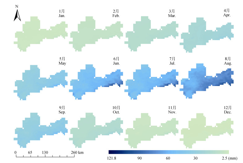
图32001—2015年张家口市坝上4县多年月均绿水量分布图
Figure3.Average monthly green water of the four counties of Zhangjiakou in Bashang area during 2001?2015
下载: 全尺寸图片幻灯片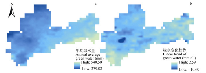
图42001—2015年张家口市坝上4县年均绿水量(a)及绿水变化趋势(b)图
Figure4.Annual average (a) and linear trend (b) of green water of the four counties of Zhangjiakou in Bashang area during 2001?2015
下载: 全尺寸图片幻灯片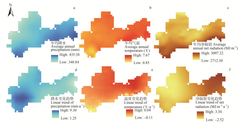
图52001—2015年张家口市坝上4县各气象因子年均值及其变化趋势分布图
Figure5.Annual average and linear trends of various weather influencing factors of the four counties of Zhangjiakou in Bashang area during 2001?2015
下载: 全尺寸图片幻灯片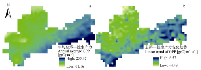
图62001—2015年张家口市坝上4县年均总第一性生产力(a)及其变化趋势(b)分布图
Figure6.Annual average (a) and linear trend (b) of gross primary productivity (GPP) of the four counties of Zhangjiakou in Bashang area during 2001?2015
下载: 全尺寸图片幻灯片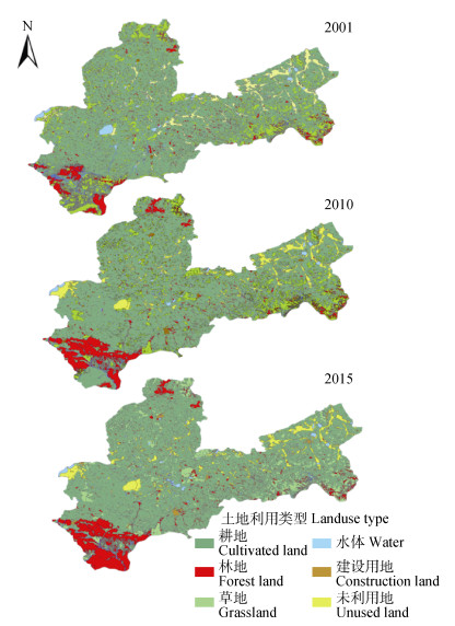
图72001年、2010年、2015年张家口市坝上4县土地利用类型图
Figure7.Spatial distribution of land use types of the four counties of Zhangjiakou in Bashang area in 2001, 2010 and 2015
下载: 全尺寸图片幻灯片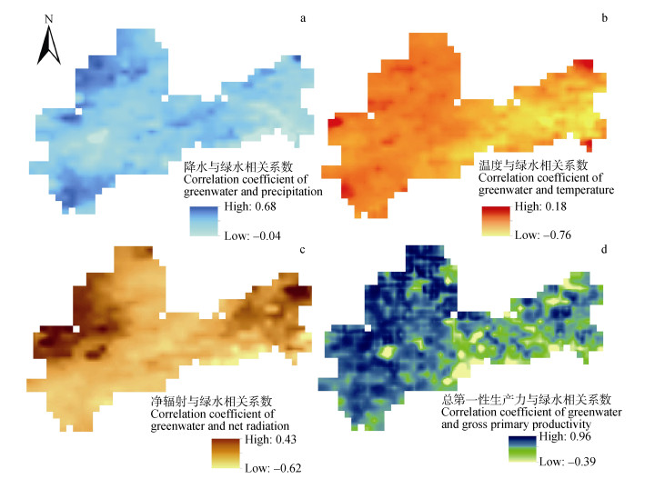
图8张家口市坝上4县各影响因子与绿水相关系数分布图
Figure8.Spatial distribution of correlation coefficients between influencing factors and green water of the four counties of Zhangjiakou in Bashang area
下载: 全尺寸图片幻灯片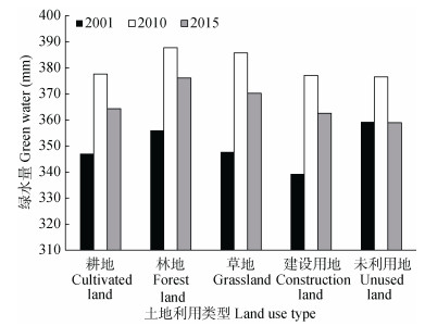
图92001年、2010年、2015年张家口市坝上4县各土地利用类型绿水量
Figure9.Green water of different land use types of the four counties of Zhangjiakou in Bashang area in 2001, 2010 and 2015
下载: 全尺寸图片幻灯片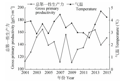
图102001—2015年张家口市坝上4县总第一性生产力与温度变化图
Figure10.Annual variations of gross primary productivity and temperature of the four counties of Zhangjiakou in Bashang area from 2001 to 2015
下载: 全尺寸图片幻灯片表1研究所用数据类型、来源及时空分辨率
Table1.Data source and spatio-temporal resolution used in the study
| 数据类型 Data type | 空间分辨率 Spatial resolution | 时间分辨率 Temporal resolution (d) | 数据来源 Data source |
| ET | 0.05° | 8 | 全球陆表特征参量(GLASS)蒸散产品 ET products of GLASS (http://www.geodata.cn/) |
| 降雨 Precipitation | 0.1° | 1 | 中国区域地面气象要素驱动数据集 China meteorological forcing dataset (https://data.tpdc.ac.cn/zh-hans/) |
| 气温 Temperature | 0.1° | 1 | 中国区域地面气象要素驱动数据集 China meteorological forcing dataset (https://data.tpdc.ac.cn/zh-hans/) |
| 净辐射 Net radiation | 0.05° | 1 | 详见参考文献[23] Showed in the reference [23] |
| 总第一性生产力 Gross primary productivity (GPP) | 0.05° | 8 | 全球陆表特征参量(GLASS)总第一性生产力产品 GPP products of GLASS (http://www.geodata.cn/) |
| 土壤湿度 Soil moisture | 0.1° | 1 | 基于微波数据同化的中国土壤水分数据集 Soil moisture dataset of China based on microwave data assimilation (http://data.tpdc.ac.cn/zh-hans/) |
| 土地利用 Land use | 30 m | — | 中国科学院资源环境与数据中心土地利用数据产品 Land use products of Resources and Environment Science and Data Center, Chinese Academy of Sciences (http://www.resdc.cn/) |
下载: 导出CSV表22001年、2010年、2015年张家口市坝上4县各土地利用类型面积占比
Table2.Proportions of different land use types of the four countiesof Zhangjiakou in Bashang area in 2001, 2010 and 2015 ?
| 土地利用类型Land use type | 2001 | 2010 | 2015 |
| 耕地Cultivated land | 62.60 | 64.85 | 61.16 |
| 林地Forest land | 6.33 | 9.54 | 11.46 |
| 草地Grassland | 20.91 | 15.71 | 16.59 |
| 水体Water | 2.06 | 1.25 | 1.37 |
| 建设用地Construction land | 2.59 | 3.03 | 3.66 |
| 未利用地Unused land | 5.51 | 5.62 | 5.75 |
下载: 导出CSV参考文献
| [1] | FALKENMARK M. Land-water Linkages: A Synopsis. Land and Water Integration and River Basin Management[R]. Rome: Landand Water Bulletin, 1995: 15-16 |
| [2] | 刘昌明. 蓝水与绿水的确切定义及其转化机制问题[J]. 南水北调与水利科技, 2020, 18(1): 25 https://www.cnki.com.cn/Article/CJFDTOTAL-NSBD202001006.htm LIU C M. Precise definition of blue water and green water and their mutual transformation[J]. South-to-North Water Transfers and Water Science & Technology, 2020, 18(1): 25 https://www.cnki.com.cn/Article/CJFDTOTAL-NSBD202001006.htm |
| [3] | ALEXANDRATOS N, WILEY J, CHICHESTES S. World Agriculture: Towards 2010[R]. Rome: FAO, 1995 |
| [4] | ROCKSTR?M J, FALKENMARK M, KARLBERG L, et al. Future water availability for global food production: The potential of green water for increasing resilience to global change[J]. Water Resources Research, 2009, 45(7): W00A12 http://www.cabdirect.org/abstracts/20093291209.html |
| [5] | 许炯心. 黄河中游绿水系数变化及其生态环境意义[J]. 生态学报, 2015, 35(22): 7298-7307 https://www.cnki.com.cn/Article/CJFDTOTAL-STXB201522004.htm XU J X. Increasing trend of green water coefficient in the middle Yellow River Basin and the eco-environmental implications[J]. Acta Ecologica Sinica, 2015, 35(22): 7298-7307 https://www.cnki.com.cn/Article/CJFDTOTAL-STXB201522004.htm |
| [6] | GERTEN D, HOFF H, BONDEAU A, et al. Contemporary "green" water flows: Simulations with a dynamic global vegetation and water balance model[J]. Physics and Chemistry of the Earth, Parts A/B/C, 2005, 30(6/7): 334-338 |
| [7] | 夏露, 宋孝玉, 符娜, 等. 黄土高塬沟壑区绿水对土地利用和气候变化的响应研究——以南小河沟流域为例[J]. 水利学报, 2017, 48(6): 678-688 https://www.cnki.com.cn/Article/CJFDTOTAL-SLXB201706006.htm XIA L, SONG X Y, FU N, et al. Impacts of land use change and climate variation on green water in the Loess Plateau Gully Region-A case study of Nanxiaohegou basin[J]. Journal of Hydraulic Engineering, 2017, 48(6): 678-688 https://www.cnki.com.cn/Article/CJFDTOTAL-SLXB201706006.htm |
| [8] | ABBASPOUR K C, FARAMARZI M, GHASEMI S S, et al. Assessing the impact of climate change on water resources in Iran[J]. Water Resources Research, 2009, 45(10): W10434 http://www.cabdirect.org/abstracts/20103042250.html |
| [9] | 刘昌明, 李艳忠, 刘小莽, 等. 黄河中游植被变化对水量转化的影响分析[J]. 人民黄河, 2016, 38(10): 7-12 doi: 10.3969/j.issn.1000-1379.2016.10.002 LIU C M, LI Y Z, LIU X M, et al. Impact of vegetation change on water transformation in the middle Yellow River[J]. Yellow River, 2016, 38(10): 7-12 doi: 10.3969/j.issn.1000-1379.2016.10.002 |
| [10] | 夏露. 基于绿水理论的砚瓦川流域生态水文过程对变化环境的响应[D]. 西安: 西安理工大学, 2019 XIA L. Responses of eco-hydrological process to changing environment in Yanwachuan basin based on green water theory[D]. Xi'an: Xi'an University of Technology, 2019 |
| [11] | ZANG C, LIU J, JIANG L, et al. Impacts of human activities and climate variability on green and blue water flows in the Heihe River Basin in Northwest China[J]. Hydrology and Earth System Sciences Discussions, 2013, 10(7): 9477-9504 http://adsabs.harvard.edu/abs/2013HESSD..10.9477Z |
| [12] | 赵安周, 赵玉玲, 刘宪锋, 等. 气候变化和人类活动对渭河流域蓝水绿水影响研究[J]. 地理科学, 2016, 36(4): 571-579 https://www.cnki.com.cn/Article/CJFDTOTAL-DLKX201604011.htm ZHAO A Z, ZHAO Y L, LIU X F, et al. Impact of human activities and climate variability on green and blue water resources in the Weihe River basin of northwest China[J]. Scientia Geographica Sinica, 2016, 36(4): 571-579 https://www.cnki.com.cn/Article/CJFDTOTAL-DLKX201604011.htm |
| [13] | 冯畅, 毛德华, 周慧, 等. 气候变化对涟水流域蓝水绿水资源的影响[J]. 长江流域资源与环境, 2017, 26(10): 1525-1537 https://www.cnki.com.cn/Article/CJFDTOTAL-CJLY201710005.htm FENG C, MAO D H, ZHOU H, et al. Impacts of climate change on blue and green water resources in the Lianshui River basin[J]. Resources and Environment in the Yangtze Basin, 2017, 26(10): 1525-1537 https://www.cnki.com.cn/Article/CJFDTOTAL-CJLY201710005.htm |
| [14] | MOREIRA A A, RUHOFF A L, ROBERTI D R, et al. Assessment of terrestrial water balance using remote sensing data in South America[J]. Journal of Hydrology, 2019, 575: 131-147 doi: 10.1016/j.jhydrol.2019.05.021 |
| [15] | HE M Z, KIMBALL J S, YI Y H, et al. Satellite data-driven modeling of field scale evapotranspiration in croplands using the MOD16 algorithm framework[J]. Remote Sensing of Environment, 2019, 230: 111201 doi: 10.1016/j.rse.2019.05.020 |
| [16] | 贺添, 邵全琴. 基于MOD16产品的我国2001-2010年蒸散发时空格局变化分析[J]. 地球信息科学学报, 2014, 16(6): 979-988 https://www.cnki.com.cn/Article/CJFDTOTAL-DQXX201406019.htm HE T, SHAO Q Q. Spatial-temporal variation of terrestrial evapotranspiration in China from 2001 to 2010 using MOD16 products[J]. Journal of Geo-Information Science, 2014, 16(6): 979-988 https://www.cnki.com.cn/Article/CJFDTOTAL-DQXX201406019.htm |
| [17] | TANG R L, SHAO K, LI Z L, et al. Multiscale validation of the 8-day MOD16 evapotranspiration product using flux data collected in China[J]. IEEE Journal of Selected Topics in Applied Earth Observations and Remote Sensing, 2015, 8(4): 1478-1486 doi: 10.1109/JSTARS.2015.2420105 |
| [18] | 梁顺林, 程洁, 贾坤, 等. 陆表定量遥感反演方法的发展新动态[J]. 遥感学报, 2016, 20(5): 875-898 https://www.cnki.com.cn/Article/CJFDTOTAL-YGXB201605019.htm LIANG S L, CHENG J, JIA K, et al. Recent progress in land surface quantitative remote sensing[J]. Journal of Remote Sensing, 2016, 20(5): 875-898 https://www.cnki.com.cn/Article/CJFDTOTAL-YGXB201605019.htm |
| [19] | 王彦芳, 裴宏伟. 1980-2015年河北坝上地区生态环境状况评价与对策研究[J]. 生态经济, 2018, 34(1): 186-190 https://www.cnki.com.cn/Article/CJFDTOTAL-STJJ201801037.htm WANG Y F, PEI H W. Evaluation on eco-environment quality of Bashang region in Hebei Province from 1980 to 2015[J]. Ecological Economy, 2018, 34(1): 186-190 https://www.cnki.com.cn/Article/CJFDTOTAL-STJJ201801037.htm |
| [20] | 李志祥, 田明中, 武法东, 等. 河北坝上地区生态环境评价[J]. 地理与地理信息科学, 2005, 21(2): 91-93 doi: 10.3969/j.issn.1672-0504.2005.02.022 LI Z X, TIAN M Z, WU F D, et al. Ecological environment evaluation on Bashang District in Hebei Province[J]. Geography and Geo-Information Science, 2005, 21(2): 91-93 doi: 10.3969/j.issn.1672-0504.2005.02.022 |
| [21] | HE J, YANG K, TANG W J, et al. The first high-resolution meteorological forcing dataset for land process studies over China[J]. Scientific Data, 2020, 7(1): 25 doi: 10.1038/s41597-020-0369-y |
| [22] | ANG K, HE J, TANG W J, et al. On downward shortwave and longwave radiations over high altitude regions: Observation and modeling in the Tibetan Plateau[J]. Agricultural and Forest Meteorology, 2010, 150(1): 38-46 doi: 10.1016/j.agrformet.2009.08.004 |
| [23] | 张晓龙. 基于遥感和通量观测的实际蒸散发机理研究与模型应用[D]. 西安: 西安理工大学, 2019 Zhang X L. Research on the mechanism and model of actual evapotranspiration from satellite and flux observations[D]. Xi'an: Xi'an University of Technology, 2019 |
| [24] | YANG K, CHEN Y Y, HE J, et al. Development of a daily soil moisture product for the period of 2002-2011 in Chinese mainland[J]. Science China Earth Sciences, 2020, 63(8): 1113-1125 doi: 10.1007/s11430-019-9588-5 |
| [25] | YANG K, ZHU L, CHEN Y Y, et al. Land surface model calibration through microwave data assimilation for improving soil moisture simulations[J]. Journal of Hydrology, 2016, 533: 266-276 doi: 10.1016/j.jhydrol.2015.12.018 |
| [26] | YANG K, KOIKE T, KAIHOTSU I, et al. Validation of a dual-pass microwave land data assimilation system for estimating surface soil moisture in semiarid regions[J]. Journal of Hydrometeorology, 2009, 10(3): 780-793 doi: 10.1175/2008JHM1065.1 |
| [27] | YANG K, WATANABE T, KOIKE T, et al. Auto-calibration system developed to assimilate AMSR-E data into a land surface model for estimating soil moisture and the surface energy budget[J]. Journal of the Meteorological Society of Japan, 2007, 85A: 229-242 doi: 10.2151/jmsj.85A.229 |
| [28] | 王琥. 华北农牧交错带地区人工草地水分利用与水分消耗研究[D]. 北京: 中国农业科学院, 2007: 24 WANG H. Study on the utilization and consumption of water for sward in semiarid agro-pastoral transitional zone of North China[D]. Beijing: Chinese Academy of Agricultural Sciences, 2007: 24 |
| [29] | 张守红, 刘苏峡, 莫兴国, 等. 阿克苏河流域气候变化对潜在蒸散量影响分析[J]. 地理学报, 2010, 65(11): 1363-1370 doi: 10.11821/xb201011006 ZHANG S H, LIU S X, MO X G, et al. Assessing the impact of climate change on reference evapotranspiration in Aksu River Basin[J]. Acta Geographica Sinica, 2010, 65(11): 1363-1370 doi: 10.11821/xb201011006 |
| [30] | 王强, 张廷斌, 易桂花, 等. 横断山区2004-2014年植被NPP时空变化及其驱动因子[J]. 生态学报, 2017, 37(9): 3084-3095 https://www.cnki.com.cn/Article/CJFDTOTAL-STXB201709023.htm WANG Q, ZHANG T B, YI G H, et al. Tempo-spatial variations and driving factors analysis of net primary productivity in the Hengduan mountain area from 2004 to 2014[J]. Acta Ecologica Sinica, 2017, 37(9): 3084-3095 https://www.cnki.com.cn/Article/CJFDTOTAL-STXB201709023.htm |
| [31] | 马磊, 闫浩文, 何毅, 等. 2001-2015年喜马拉雅南麓地区植被变化遥感监测[J]. 干旱区地理, 2017, 40(2): 405-414 https://www.cnki.com.cn/Article/CJFDTOTAL-GHDL201702023.htm MA L, YAN H W, HE Y, et al. Vegetation changes in south Himalayas areas based on remote sensing monitoring during 2001-2015[J]. Arid Land Geography, 2017, 40(2): 405-414 https://www.cnki.com.cn/Article/CJFDTOTAL-GHDL201702023.htm |
| [32] | 于贵瑞, 王秋凤, 于振良. 陆地生态系统水-碳耦合循环与过程管理研究[J]. 地球科学进展, 2004, 19(5): 831-839 doi: 10.3321/j.issn:1001-8166.2004.05.022 YU G R, WANG Q F, YU Z L. Study on the coupling cycle of water-carbon and process management in terrestrial ecosystem[J]. Advance in Earth Sciences, 2004, 19(5): 831-839 doi: 10.3321/j.issn:1001-8166.2004.05.022 |
| [33] | 吴桂平, 刘元波, 赵晓松, 等. 基于MOD16产品的鄱阳湖流域地表蒸散量时空分布特征[J]. 地理研究, 2013, 32(4): 617-627 https://www.cnki.com.cn/Article/CJFDTOTAL-DLYJ201304004.htm WU G P, LIU Y B, ZHAO X S, et al. Spatio-temporal variations of evapotranspiration in Poyang Lake Basin using MOD16 products[J]. Geographical Research, 2013, 32(4): 617-627 https://www.cnki.com.cn/Article/CJFDTOTAL-DLYJ201304004.htm |
| [34] | 杨秀芹, 王磊, 王凯. 基于MOD16产品的淮河流域实际蒸散发时空分布[J]. 冰川冻土, 2015, 37(5): 1343-1352 https://www.cnki.com.cn/Article/CJFDTOTAL-BCDT201505022.htm YANG X Q, WANG L, WANG K. Spatio-temporal distribution of terrestrial evapotranspiration in Huaihe River basin based on MOD16 ET data[J]. Journal of Glaciology and Geocryology, 2015, 37(5): 1343-1352 https://www.cnki.com.cn/Article/CJFDTOTAL-BCDT201505022.htm |
| [35] | 孙雷刚, 王绍强, 徐全洪, 等. 京津冀地区生态系统生产力估算及时空格局分析[J]. 地理与地理信息科学, 2019, 35(5): 109-117 https://www.cnki.com.cn/Article/CJFDTOTAL-DLGT201905019.htm SUN L G, WANG S Q, XU Q H, et al. Ecosystem productivity and its spatio-temporal pattern in Beijing-Tianjin-Hebei region[J]. Geography and Geo-Information Science, 2019, 35(5): 109-117 https://www.cnki.com.cn/Article/CJFDTOTAL-DLGT201905019.htm |
| [36] | 杨佳, 郝桂珍, 张婧, 等. 1960-2016年冀西北地区降水时空变化特征研究[J]. 水资源与水工程学报, 2019, 30(5): 117-123 https://www.cnki.com.cn/Article/CJFDTOTAL-XBSZ201905018.htm YANG J, HAO G Z, ZHANG J, et al. The spatial and temporal variation characteristics of precipitation in Northwest Hebei Province during 1960-2016[J]. Journal of Water Resources and Water Engineering, 2019, 30(5): 117-123 https://www.cnki.com.cn/Article/CJFDTOTAL-XBSZ201905018.htm |
| [37] | 李元菲, 张兰霞, 曹永强, 等. 河北省潜在蒸散量时空变化特征及气候影响因素分析[J]. 南水北调与水利科技, 2019, 17(3): 67-78 https://www.cnki.com.cn/Article/CJFDTOTAL-NSBD201903009.htm LI Y F, ZHANG L X, CAO Y Q, et al. Spatiotemporal variations of potential evapotranspiration and its climate influencing factors in Hebei Province[J]. South-to-North Water Transfers and Water Science & Technology, 2019, 17(3): 67-78 https://www.cnki.com.cn/Article/CJFDTOTAL-NSBD201903009.htm |
| [38] | 马梓策, 于红博, 张巧凤. 2000-2017年锡林河流域地表蒸散量的时空特征及其影响因素[J]. 中国农村水利水电, 2020(3): 18-24 https://www.cnki.com.cn/Article/CJFDTOTAL-ZNSD202003004.htm MA Z C, YU H B, ZHANG Q F. Spatio-temporal characteristics of evapotranspiration and its influencing factors in Xilin river basin from 2000 to 2017[J]. China Rural Water and Hydropower, 2020(3): 18-24 https://www.cnki.com.cn/Article/CJFDTOTAL-ZNSD202003004.htm |
| [39] | 黄葵, 卢毅敏, 魏征, 等. 土地利用和气候变化对海河流域蒸散发时空变化的影响[J]. 地球信息科学学报, 2019, 21(12): 1888-1902 doi: 10.12082/dqxxkx.2019.190269 HUANG K, LU Y M, WEI Z, et al. Effects of land use and climate change on spatiotemporal changes of evapotranspiration in Haihe River basin[J]. Journal of Geo-Information Science, 2019, 21(12): 1888-1902 doi: 10.12082/dqxxkx.2019.190269 |
| [40] | XIONG Y J, ZHAO S H, YIN J, et al. Effects of evapotranspiration on regional land surface temperature in an arid oasis based on thermal remote sensing[J]. IEEE Geoscience and Remote Sensing Letters, 2016, 13(12): 1885-1889 doi: 10.1109/LGRS.2016.2616409 |
| [41] | GOROSHI S, PRADHAN R, SINGH R P, et al. Trend analysis of evapotranspiration over India: Observed from long-term satellite measurements[J]. Journal of Earth System Science, 2017, 126(8): 1-21 doi: 10.1007/s12040-017-0891-2 |
| [42] | 张明明. 2000-2015年中国干旱半干旱区蒸散发时空变化及其影响因素分析[D]. 西安: 长安大学, 2019: 28 ZHANG M M. Analysis of the temporal and spatial variation of evapotranspiration and its driving factors in arid and semi-arid region of China from 2000 to 2015[D]. Xi'an: Chang'an University, 2019: 28 |
| [43] | 杨宇娜, 汪季, 张成福, 等. 吉兰泰及周边地区蒸散发的时空变化规律[J]. 灌溉排水学报, 2019, 38(S2): 30-36 https://www.cnki.com.cn/Article/CJFDTOTAL-GGPS2019S2005.htm YANG Y N, WANG J, ZHANG C F, et al. Spatial and temporal variations of evapotranspiration in Jilantai and its surrounding areas[J]. Journal of Irrigation and Drainage, 2019, 38(S2): 30-36 https://www.cnki.com.cn/Article/CJFDTOTAL-GGPS2019S2005.htm |
| [44] | 安塞. 京津冀地区土地利用/覆被与地表蒸散发动态变化及关系研究[D]. 石家庄: 河北科技大学, 2018: 47-56 AN S. Research on dynamic change and relationship between land use/cover and evapotranspiration in Beijing-Tianjin-Hebei region[D]. Shijiazhuang: Hebei University of Science and Technology, 2018: 47-56 |
| [45] | 李发鹏, 徐宗学, 李景玉. 基于MODIS数据的黄河三角洲区域蒸散发量时空分布特征[J]. 农业工程学报, 2009, 25(2): 113-120 https://www.cnki.com.cn/Article/CJFDTOTAL-NYGU200902024.htm LI F P, XU Z X, LI J Y. Characteristics of the spatial and temporal distribution for regional evapotranspiration in the Yellow River Delta based on MODIS data[J]. Transactions of the Chinese Society of Agricultural Engineering, 2009, 25(2): 113-120 https://www.cnki.com.cn/Article/CJFDTOTAL-NYGU200902024.htm |
