李会龙1,
杨永辉1, 2,,,
史尚忠4
1.中国科学院遗传与发育生物学研究所农业资源研究中心/中国科学院农业水资源重点实验室/河北省节水农业重点实验室 石家庄 050022
2.中国科学院大学中丹学院 北京 101400
3.中国-丹麦科教中心 北京 101400
4.太原生态工程学校 太原 030025
基金项目: 国家自然科学基金面上项目41671021
详细信息
作者简介:俞琳飞, 主要研究方向为山区降水反演。E-mail:lfyu@sjziam.ac.cn
通讯作者:杨永辉, 主要研究方向为生态水文。E-mail:yonghui.yang@ms.sjziam.ac.cn
中图分类号:P461计量
文章访问数:440
HTML全文浏览量:0
PDF下载量:279
被引次数:0
出版历程
收稿日期:2019-10-23
录用日期:2019-12-09
刊出日期:2020-02-01
Spatial and temporal precipitation patterns using the CMOPRH CRT product over the Taihang Mountains
YU Linfei1, 2, 3,,LI Huilong1,
YANG Yonghui1, 2,,,
SHI Shangzhong4
1. Center for Agricultural Resources Research, Institute of Genetics and Developmental Biology, Chinese Academy of Sciences/Key Laboratory of Agricultural Water Resource, Chinese Academy of Sciences/Hebei Laboratory of Agricultural Water-saving, Shijiazhuang 050022, China
2. Sino-Danish College, University of Chinese Academy of Sciences, Beijing 101400, China
3. Sino-Danish Center for Education and Research, Beijing 101400, China
4. Taiyuan College of Ecoengineering, Taiyuan 030025, China
Funds: the National Natural Science Foundation of China41671021
More Information
Corresponding author:YANG Yonghui, E-mail:yonghui.yang@ms.sjziam.ac.cn
摘要
HTML全文
图
参考文献
相关文章
施引文献
资源附件
访问统计
摘要
摘要:为有效利用太行山区降水资源,实现科学的水资源管理和生态建设,本研究利用1998—2017年CMORPH CRT卫星降水产品数据探究山区降水的时空格局和变化趋势,并通过18个地面雨量站的数据验证山区多年来降水趋势变化。结果表明:在年尺度上,1998—2017年太行山区年均降水量和各季节降水量无明显变化趋势,太行山区南坡和东坡降水量高于北坡和西坡;在月尺度上,7月是全年降水的主要贡献时段,占全年总降水量的7.2%~32.4%,其次是8月和6月。太行山区南部和西北部降水呈现下降趋势,年均降水量减少2~6 mm;山区西部和北部降水呈现增长趋势,年均增加量大于8 mm;7月是山区降水趋势差异最大的月份,趋势变化范围在-8.6~8 mm·a-1。根据地面实测数据验证降水变化趋势,在年尺度上,两者数据计算得到的降水趋势呈现极显著相关(P < 0.01);在季节尺度上,冬季(干季)和夏季(湿季)降水趋势变化与地面实测数据的降水趋势具有极显著相关性(R=0.902,P < 0.001;R=0.550,P=0.018),但在春季和秋季相关性不显著。根据1998—2017年降水趋势的空间分布栅格图,提取每一栅格的像元值,再将提取所得的降水趋势(PT)划分为6个区间(PT≤-5 mm·a-1、-5 mm·a-1 < PT≤0 mm·a-1、0 mm·a-1 < PT≤5 mm·a-1、5 mm·a-1 < PT≤10 mm·a-1、10 mm·a-1 < PT≤15 mm·a-1和PT>15 mm·a-1),在不同的趋势区间探索20年来的降水趋势变化特征,研究发现在降水趋势>5 mm·a-1的区间,降水量从1998年到2017年呈现显著增加的趋势。基于高分辨率卫星数据阐明太行山区降水时空格局和变化趋势,能够为该区域水资源合理利用和生态恢复提供建议和支持。
关键词:CMORPH CRT产品/
太行山区/
降水时空格局/
降水趋势
Abstract:In order to effectively use precipitation over the Taihang Mountains, and to perform water resource management and ecological construction scientifically, we used satellite precipitation data to explore the spatio-temporal precipitation pattern and precipitation trend over the Taihang Mountains from 1998 to 2017. In general, the complex terrain and sparse meteorological stations lead to limited precipitation measurement in mountainous areas especially in high-altitude regions. Satellite-based precipitation measurement is an effective supplement for measuring precipitation information in such regions. The CMOPRH CRT product is recognized worldwide. A previous study had proved the applicability of CMORPH CRT over the Taihang Mountains owing to the lower root mean square error and relative bias in this region, which indicated that this product had applicability over the Taihang Mountains. Therefore, in this study, we adopted the method of time series analysis and trend analysis to explore the spatial and temporal patterns of precipitation and precipitation trend over the Taihang Mountains based on the data obtained using the CMORPH CRT product from 1998 to 2017. Meanwhile, the ground observations of 18 rain gauges were used to validate the precipitation trend measured using the CMOPRH CRT product over the Taihang Mountains with "Pixel to Point" extraction method via ArcGIS. The results showed that there was no significant variation trend in the annual and seasonal precipitation from 1998 to 2017 over the Taihang Mountains. Higher precipitation occurred in the southern and eastern regions of the Taihang Mountains than in the northern and western regions. On a monthly scale, the precipitation in July accounted for the highest rate of annual precipitation, 7.2%-32.4% of the total annual precipitation, followed by August and June. There was a decrease trend in the south and northwest regions of the Taihang Mountains, and decreased by 2-6 mm·a-1 on an average. The increasing precipitation trend appeared in the western and northern regions of the Taihang Mountains, and the annual precipitation increased by more than 8 mm. The greatest difference in precipitation trend was found in July on a spatial scale with a variation range of -8.6 to 8 mm·a-1. We used actual data obtained using rain gauges to validate the precipitation trend measured using CMORPH CRT. Two sets of data showed a strong significant correlation at the annual scale. On the seasonal scale, the precipitation trend in winter (dry season) and summer (wet season) had a strong significant correlation with the precipitation trend measured using rain gauges, but the precipitation trend in spring and autumn did not show a significant correlation with the precipitation measured using rain gauges. We extracted the pixel values according to the spatial pattern of precipitation trend from 1998 to 2017 over the Taihang Mountains, and further divided them into six different precipitation trend (PT) ranges (PT ≤ -5 mm·a-1, -5 mm·a-1 < PT ≤ 0 mm·a-1, 0 mm·a-1 < PT ≤ 5 mm·a-1, 5 mm·a-1 < PT ≤ 10 mm·a-1, 10 mm·a-1 < PT ≤ 15 mm·a-1, and PT ≥ 15 mm·a-1) depending on the actual precipitation trend over study areas. There was a significant increase in precipitation from 1998 to 2017 in the PT > 5 mm·a-1 area.
Key words:CMORPH CRT product/
Taihang Mountains/
Spatial-temporal pattern of precipitation/
Precipitation trend
HTML全文
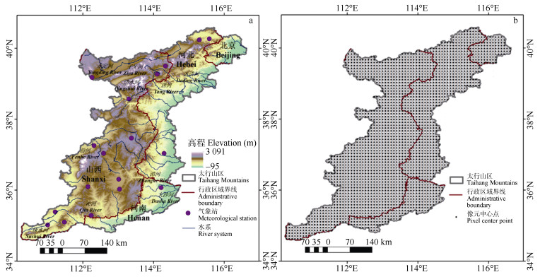
图1太行山区地形、气象站分布(a)和CMORPH CRT产品像元示意图(b)
Figure1.Topography and distribution of meteorological stations (a) and the pixel distribution of CMORPH CRT product (b) of the Taihang Mountains
 下载: 全尺寸图片幻灯片
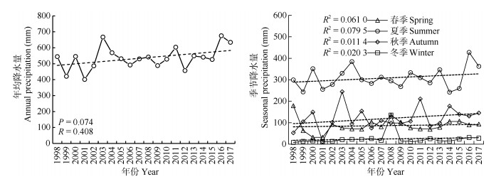
图2基于CMORPH CRT产品的太行山区年降水(a)和季节降水(b)时间变化特征(1998—2017年)
Figure2.Annual precipitation (a) and seasonal precipitation (b) measured by CMORPH CRT from 1998 to 2017 over the Taihang Mountains
下载: 全尺寸图片幻灯片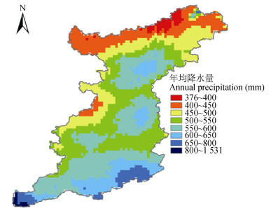
图3基于CMORPH CRT产品数据的太行山区年均降水空间分布特征(1998—2017年)
Figure3.Spatial distribution pattern of mean annual precipitation measured by CMORPH CRT from 1998 to 2017 over the Taihang Mountains
下载: 全尺寸图片幻灯片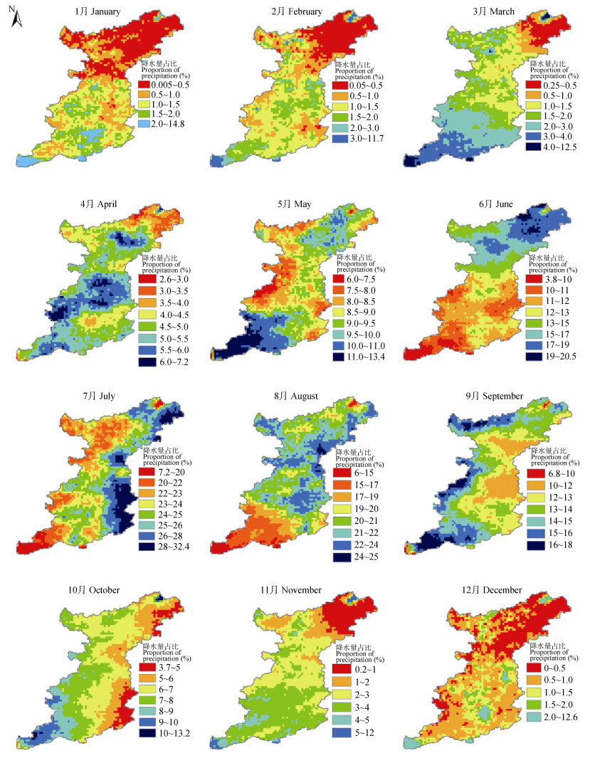
图4基于CMORPH CRT产品数据太行山区各月降水量占年降水的空间分布图(1998—2017年)
Figure4.Contribution of precipitation occurring in each month to mean annul precipitation measured by CMORPH CRT from 1998 to 2017 over the Taihang Mountains
下载: 全尺寸图片幻灯片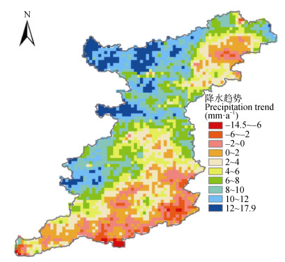
图5基于CMORPH CRT产品数据的太行山区年降水空间趋势分析(1998—2017年)
Figure5.Precipitation trend analysis based on CMORPH CRT at an annual scale from 1998 to 2017 over the Taihang Mountains
下载: 全尺寸图片幻灯片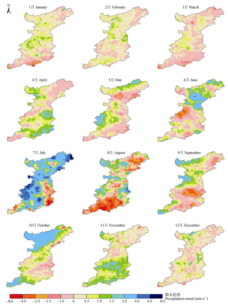
图6基于CMORPH CRT产品数据的太行山区各月降水空间趋势分析(1998—2017年)
Figure6.Analysis of spatial distribution of precipitation trend based on CMORPH CRT data in monthly scale from 1998 to 2017 over the Taihang Mountains
下载: 全尺寸图片幻灯片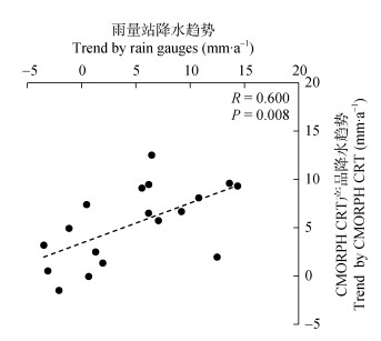
图7基于CMORPH CRT降雨数据的太行山区年尺度降雨趋势与地面观测数据的相关性(1998—2017年)
Figure7.Validation of precipitation trend analysis based on CMORPH CRT against that from rain gauge observations at the annual scale from 1998 to 2017 over the Taihang Mountains
下载: 全尺寸图片幻灯片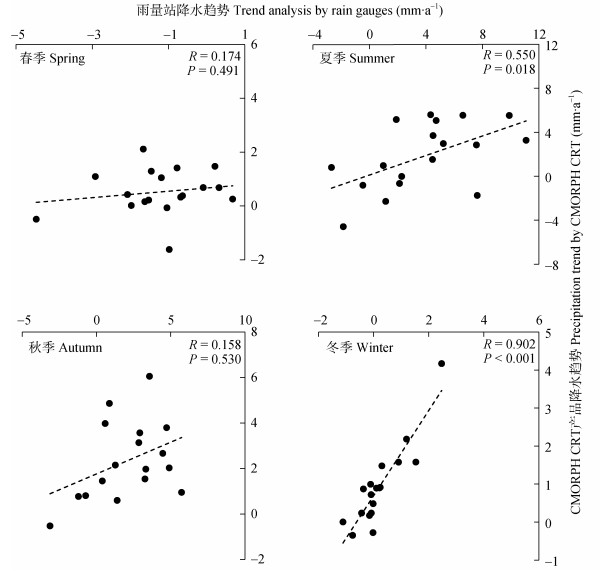
图8CMORPH CRT产品数据与地面观测数据的太行山区1998—2017年季度尺度降水趋势分析验证
Figure8.Validation of precipitation trend analysis based on CMORPH CRT against rain gauge observations at the seasonal scale from 1998 to 2017 over the Taihang Mountains
下载: 全尺寸图片幻灯片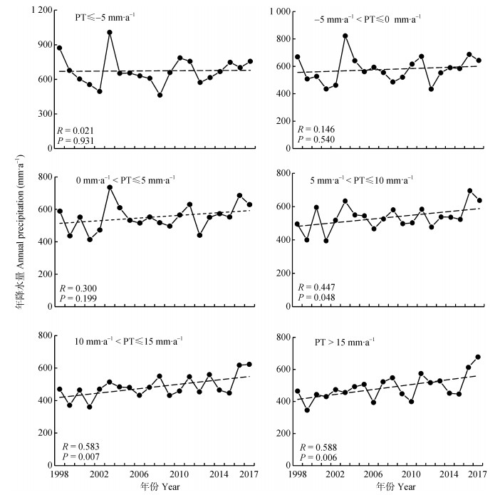
图9太行山基于像元尺度的不同降水趋势(PT)间隔的年降水量变化分析(1998—2017年)
Figure9.Variation of mean annual precipitation over the Taihang Mountains with precipitation trend (PT) at each pixel (8 km) varying in different intervals from 1998 to 2017
下载: 全尺寸图片幻灯片参考文献
| [1] | 贾仰文, 郝春沣, 牛存稳, 等.典型山地降水径流时空演变及"水-热-人-地"匹配性分析[J].地理学报, 2019, 74(11):2288-2302 http://www.wanfangdata.com.cn/details/detail.do?_type=perio&id=dlxb201911008 JIA Y W, HAO C F, NIU C W, et al. Spatio-temporal variations of precipitation and runoff and analyses of water-heat-human-land matching characteristics in typical mountainous areas of China[J]. Acta Geographica Sinica, 2019, 74(11):2288-2302 http://www.wanfangdata.com.cn/details/detail.do?_type=perio&id=dlxb201911008 |
| [2] | 杜军凯, 贾仰文, 李晓星, 等.基于TRMM卫星降水的太行山区降水时空分布格局[J].水科学进展, 2019, 30(1):1-13 http://d.old.wanfangdata.com.cn/Periodical/skxjz201901001 DU J K, JIA Y W, LI X X, et al. Study on the spatial-temporal distribution pattern of precipitation in the Taihang Mountain region using TRMM data[J]. Advances in Water Science, 2019, 30(1):1-13 http://d.old.wanfangdata.com.cn/Periodical/skxjz201901001 |
| [3] | 孙宏勇, 刘昌明, 王振华.太行山前平原近40年降水的变化趋势及其对作物生产的影响[J].中国生态农业学报, 2007, 15(6):18-21 http://www.ecoagri.ac.cn/zgstny/ch/reader/view_abstract.aspx?file_no=2007604&flag=1 SUN H Y, LIU C M, WANG Z H. Changing trend of precipitation and its effects on crop productivity in the piedment of Taihang Mountain[J]. Chinese Journal of Eco-Agriculture, 2007, 15(6):18-21 http://www.ecoagri.ac.cn/zgstny/ch/reader/view_abstract.aspx?file_no=2007604&flag=1 |
| [4] | 田恬, 宋献方, 杨丽虎, 等.太行山丘陵区降水时空分布特征及影响因素分析——以崇陵流域为例[J].资源科学, 2016, 38(6):1192-1202 http://www.wanfangdata.com.cn/details/detail.do?_type=perio&id=zykx201606018 TIAN T, SONG X F, YANG L H, et al. Spatial-temporal variation and factors affecting precipitation in the hilly area of Taihang Mountain[J]. Resources Science, 2016, 38(6):1192-1202 http://www.wanfangdata.com.cn/details/detail.do?_type=perio&id=zykx201606018 |
| [5] | XIA T, WANG Z J, ZHENG H. Topography and data mining based methods for improving satellite precipitation in mountainous areas of China[J]. Atmosphere, 2015, 6(8):983-1005 http://www.wanfangdata.com.cn/details/detail.do?_type=perio&id=MDPI000000081949 |
| [6] | 韩建, 占车生, 王飞宇, 等.太行山区降水空间扩展方法与垂直地带性分析[J].山地学报, 2017, 35(6):761-768 http://d.old.wanfangdata.com.cn/Periodical/sdxb201706001 HAN J, ZHAN C S, WANG F Y, et al. Comparison of the methods of precipitation spatial expansion and analysis of vertical zonality in the Taihang Mountains[J]. Mountain Research, 2017, 35(6):761-768 http://d.old.wanfangdata.com.cn/Periodical/sdxb201706001 |
| [7] | 李晓荣, 高会, 韩立朴, 等.太行山区植被NPP时空变化特征及其驱动力分析[J].中国生态农业学报, 2017, 25(4):498-508 http://www.ecoagri.ac.cn/zgstny/ch/reader/view_abstract.aspx?file_no=20170404&flag=1 LI X R, GAO H, HAN L P, et al. Spatio-temporal variations in vegetation NPP and the driving factors in Taihang Mountain area[J]. Chinese Journal of Eco-Agriculture, 2017, 25(4):498-508 http://www.ecoagri.ac.cn/zgstny/ch/reader/view_abstract.aspx?file_no=20170404&flag=1 |
| [8] | 傅抱璞.地形和海拔高度对降水的影响[J].地理学报, 1992, 47(4):302-314 http://www.cnki.com.cn/Article/CJFDTotal-DLXB199204001.htm FU B P. The effect of topography and elevation on precipitation[J]. Acta Geographica Sinica, 1992, 47(4):302-314 http://www.cnki.com.cn/Article/CJFDTotal-DLXB199204001.htm |
| [9] | TAN M L, SANTO H. Comparison of GPM IMERG, TMPA 3B42 and PERSIANN-CDR satellite precipitation products over Malaysia[J]. Atmospheric Research, 2018, 202:63-76 http://www.wanfangdata.com.cn/details/detail.do?_type=perio&id=dca7b38686fe864f5f456fa47e216e70 |
| [10] | 郭瑞芳, 刘元波.多传感器联合反演高分辨率降水方法综述[J].地球科学进展, 2015, 30(8):891-903 http://www.wanfangdata.com.cn/details/detail.do?_type=perio&id=dqkxjz201508005 GUO R F, LIU Y B. Multi-satellite retrieval of high resolution precipitation:an overview[J]. Advances in Earth Science, 2015, 30(8):891-903 http://www.wanfangdata.com.cn/details/detail.do?_type=perio&id=dqkxjz201508005 |
| [11] | PAN M, LI H B, WOOD E. Assessing the skill of satellite-based precipitation estimates in hydrologic applications[J]. Water Resources Research, 2010, 46:201-210 http://www.wanfangdata.com.cn/details/detail.do?_type=perio&id=56f6949b2653520497f99f17a7221136 |
| [12] | BITEW M M, GEBREMICHAEL M. Evaluation of satellite rainfall products through hydrologic simulation in a fully distributed hydrologic model[J]. Water Resources Research, 2011, 47:W06526 http://www.wanfangdata.com.cn/details/detail.do?_type=perio&id=10.1029/2010WR009917 |
| [13] | SUN R C, YUAN H L, LIU X L, et al. Evaluation of the latest satellite-gauge precipitation products and their hydrologic applications over the Huaihe River basin[J]. Journal of Hydrology, 2016, 536:302-319 http://www.wanfangdata.com.cn/details/detail.do?_type=perio&id=724617c344902831a084081aa296514b |
| [14] | 王玉丹, 陈浩, 刘璨然, 等. ITPCAS和CMORPH两种遥感降水产品在陕西地区的适用性[J].干旱区研究, 2018, 35(3):579-588 http://d.old.wanfangdata.com.cn/Periodical/ghqyj201803010 WANG Y D, CHEN H, LIU C R, et al. Applicability of ITPCAS and CMORPH precipitation datasets over Shaanxi Province[J]. Arid Zone Research, 2018, 35(3):579-588 http://d.old.wanfangdata.com.cn/Periodical/ghqyj201803010 |
| [15] | SHEN Y, ZHAO P, PAN Y, et al. A high spatiotemporal gauge-satellite merged precipitation analysis over China[J]. Journal of Geophysical Research:Atmospheres, 2014, 119(6):3063-3075 http://www.wanfangdata.com.cn/details/detail.do?_type=perio&id=05a6200e8ed52a848aa0720518042bcd |
| [16] | SHEN Y, XIONG A Y, WANG Y, et al. Performance of high-resolution satellite precipitation products over China[J]. Journal of Geophysical Research Atmospheres, 2010, 115(D2):D02114 doi: 10.1029-2009JD012097/ |
| [17] | DINKU T, RUIZ F, CONNOR S J, et al. Validation and intercomparison of satellite rainfall estimates over Colombia[J]. Journal of Applied Meteorology and Climatology, 2010, 49(5):1004-1014 http://www.wanfangdata.com.cn/details/detail.do?_type=perio&id=43c90cafef0d79e061bef04d0c739fa6 |
| [18] | GUO H, CHEN S, BAO A M, et al. Comprehensive evaluation of high-resolution satellite-based precipitation products over China[J]. Atmosphere, 2016, 7(6):1-25 http://www.wanfangdata.com.cn/details/detail.do?_type=perio&id=atmosphere-07-00006 |
| [19] | 俞琳飞, 杨永辉, 周新尧, 等.中国区融合降水产品在太行山区的质量评估[J].水资源与水工程学报, 2019, DOI: 10.11705/j.issn.1672-643X.2019.06.00 YU L F, YANG Y H, ZHOU X Y, et al. Quality assessment of Chinese merged precipitation product over Taihang Mountains[J]. Journal of Water Resource & Water Engineering, 2019, DOI: 10.11705/j.issn.1672-643X.2019.06.00 |
| [20] | FU T G, HAN L P, GAO H, et al. Geostatistical analysis of pedodiversity in Taihang Mountain region in North China[J]. Geoderma, 2018, 328:91-99 http://www.wanfangdata.com.cn/details/detail.do?_type=perio&id=1950f153757761d870d853545b47da3e |
| [21] | FU T G, HAN L P, GAO H, et al. Pedodiversity and its controlling factors in mountain regions-A case study of Taihang Mountain, China[J]. Geoderma, 2018, 310:230-237 http://www.wanfangdata.com.cn/details/detail.do?_type=perio&id=d47cca3ff13c7d3c29314b40727421da |
| [22] | JOYCE R J, JANOWIAK J E, ARKIN P A, et al. CMORPH:A method that produces global precipitation estimates from passive microwave and infrared data at high spatial and temporal resolution[J]. Journal of Hydrometeorology, 2004, 5(3):487-503 http://d.old.wanfangdata.com.cn/Periodical/qx201411010 |
| [23] | MA Z Q, XU Y P, PENG J, et al. Spatial and temporal precipitation patterns characterized by TRMM TMPA over the Qinghai-Tibetan Plateau and surroundings[J]. International Journal of Remote Sensing, 2018, 39(12):3891-3907 http://www.wanfangdata.com.cn/details/detail.do?_type=perio&id=10.1080/01431161.2018.1441565 |
| [24] | 刘晓琼, 吴泽洲, 刘彦随, 等. 1960-2015年青海三江源地区降水时空特征[J].地理学报, 2019, 74(9):1803-1820 http://d.old.wanfangdata.com.cn/Periodical/dlxb201909009 LIU X Q, WU Z Z, LIU Y S, et al. Spatial-temporal characteristics of precipitation from 1960 to 2015 in the Three Rivers' Headstream Region, Qinghai, China[J]. Acta Geographica Sinica, 2019, 74(9):1803-1820 http://d.old.wanfangdata.com.cn/Periodical/dlxb201909009 |
| [25] | 闫冠华, 李巧萍, 李瑞义.太行山地形对华北暴雨影响的数值模拟试验[J].南京信息工程大学学报:自然科学版, 2015, 7(4):351-358 http://d.old.wanfangdata.com.cn/Periodical/njxxgcdxxb201504007 YAN G H, LI Q P, LI R Y. Numerical simulation for terrain effects of Taihang Mountain on heavy rainfall over North China[J]. Journal of Nanjing University of Information Science & Technology, 2015, 7(4):351-358 http://d.old.wanfangdata.com.cn/Periodical/njxxgcdxxb201504007 |
| [26] | 陈贺, 李原园, 杨志峰, 等.地形因素对降水分布影响的研究[J].水土保持研究, 2007, 14(1):119-122 http://d.old.wanfangdata.com.cn/Periodical/stbcyj200701037 CHEN H, LI Y Y, YANG Z F, et al. Research on the relationship between terrain factors and precipitation[J]. Research of Soil and Water Conservation, 2007, 14(1):119-122 http://d.old.wanfangdata.com.cn/Periodical/stbcyj200701037 |
| [27] | 林之光.地形降水气候学[M].北京:科学出版社, 1995:96-104 LIN Z G. Topographic Precipitation Climatology[M]. Beijing:Science Press, 1995:96-104 |
| [28] | 王宗敏, 丁一汇, 张迎新, 等.太行山东麓焚风天气的统计特征及机理分析Ⅰ:统计特征[J].高原气象, 2012, 31(2):547-554 http://d.old.wanfangdata.com.cn/Conference/7395778 WANG Z M, DING Y H, ZHANG Y X, et al. Feature and mechanism of the Foehn weather on east slope Taihang MountainsⅠ:Statistic feature[J]. Plateau Meteorology, 2012, 31(2):547-554 http://d.old.wanfangdata.com.cn/Conference/7395778 |
| [29] | 王丛梅, 俞小鼎, 李芷霞, 等.太行山地形影响下的极端短时强降水分析[J].气象, 2017, 43(4):425-433 http://d.old.wanfangdata.com.cn/Periodical/qx201704004 WANG C M, YU X D, LI Z X, et al. Investigation of extreme flash-rain events on the impact of Taihang Mountains[J]. Meteorological Monthly, 2017, 43(4):425-433 http://d.old.wanfangdata.com.cn/Periodical/qx201704004 |
| [30] | 王丛梅, 俞小鼎, 刘瑾, 等.弱天气尺度背景下太行山极端短时强降水预报失败案例剖析[J].气象, 2018, 44(1):107-117 http://d.old.wanfangdata.com.cn/Periodical/qx201801009 WANG C M, YU X D, LIU J, et al. Analysis of a forecast failure case of extreme flash-rain under weak synoptic-scale background in Taihang Mountain[J]. Meteorological Monthly, 2018, 44(1):107-117 http://d.old.wanfangdata.com.cn/Periodical/qx201801009 |
| [31] | 马维玲, 石培礼, 宗宁, 等.太行山区主要森林生态系统水源涵养能力[J].中国生态农业学报, 2017, 25(4):478-489 http://www.ecoagri.ac.cn/zgstny/ch/reader/view_abstract.aspx?file_no=20170402&flag=1 MA W L, SHI P L, ZONG N, et al. Water conservation capacity of forest ecosystems in Taihang Mountain[J]. Chinese Journal of Eco-Agriculture, 2017, 25(4):478-489 http://www.ecoagri.ac.cn/zgstny/ch/reader/view_abstract.aspx?file_no=20170402&flag=1 |
| [32] | 杜军凯, 贾仰文, 郝春沣, 等.太行山区蓝水绿水沿垂直带演变规律及其归因分析[J].南水北调与水利科技, 2018, 16(2):64-73 http://d.old.wanfangdata.com.cn/Periodical/nsbdyslkj201802010 DU J K, JIA Y W, HAO C F, et al. Evolution law and attribution analysis of vertical distribution of blue water and green water in Taihang Mountain region[J]. South-to-North Water Transfers and Water Science & Technology, 2018, 16(2):64-73 http://d.old.wanfangdata.com.cn/Periodical/nsbdyslkj201802010 |
