丁银平,
角媛梅,,
刘澄静
云南师范大学旅游与地理科学学院 昆明 650500
基金项目: 国家自然科学基金项目41761115
国家自然科学基金项目41271203
云南师范大学研究生科研创新重点项目ysdyjs2019166
详细信息
作者简介:刘志林, 主要从事景观生态学和自然地理学研究。E-mail:zhilin2015@foxmail.com
通讯作者:角媛梅, 主要从事景观生态学研究。E-mail:ymjiao@sina.com
中图分类号:P933计量
文章访问数:618
HTML全文浏览量:12
PDF下载量:535
被引次数:0
出版历程
收稿日期:2019-07-12
录用日期:2019-10-08
刊出日期:2020-01-01
Identification of potential abandoned farmland and driving factors in Honghe Hani Rice Terrace
LIU Zhilin,DING Yinping,
JIAO Yuanmei,,
LIU Chengjing
College of Tourism and Geography, Yunnan Normal University, Kunming 650500, China
Funds: the National Natural Science Foundation of China41761115
the National Natural Science Foundation of China41271203
the Key Research Projects of Graduate Students in Yunnan Normal Universityysdyjs2019166
More Information
Corresponding author:JIAO Yuanmei, E-mail:ymjiao@sina.com
摘要
HTML全文
图
参考文献
相关文章
施引文献
资源附件
访问统计
摘要
摘要:潜在弃耕风险耕地识别是耕地总体利用和规划的科学依据,也是实现农业可持续发展的关键手段。然而,受弃耕过程的渐进性、复杂性及其相关学科方法与技术的限制,使弃耕很难被准确地识别和预测。本研究根据道路、坡度、海拔、水源、降水、气温、人口、粮食产量等因子与弃耕风险的关系,构建了以弃耕影响因子为主导的弃耕风险指数(FARI)和以系统聚类为基础的弃耕风险识别方法,对哈尼梯田进行了实证研究。结果表明:1)哈尼梯田稳定、弱风险和高风险耕地的面积占比分别为57%、35%和8%,整体较为稳定。2)哈尼梯田弃耕风险指数呈北部高于南部,东部大于西部的空间特征。3)在区位上哈尼梯田弃耕高风险耕地(34.95 km2)主要分布在县域边界处,该区耕作条件差,是退耕还林还草、修复生态的关键区;稳定耕地(234.87 km2)主要分布在元阳县的东中部,耕作条件适宜,是本区粮食安全与遗产保护的核心区。4)在影响因子上,稳定耕地区主要受人口、粮食产量、道路距离等因子的影响,其次为坡度、河流距离和海拔;弱风险耕地区受降水因子影响最大,其他环境因子的影响均较小;高风险耕地区主要受气温、坡度、海拔和河流距离等因子的影响。总之,哈尼梯田总体较为稳定,弃耕风险小,且不同弃耕风险程度耕地的影响因子不同。
关键词:哈尼梯田/
农业文化遗产/
耕地/
弃耕风险指数(FARI)/
弃耕因子
Abstract:The identification of farmland at risk of abandonment is not only the scientific basis for utilization planning and management of overall farmland in a region but also a key measurement of agricultural sustainability. However, the accuracy of identification results can be affected by the gradualness and complexity of abandonment process and limited by the development of current relevant technologies. In response to these challenges, a set of scientific identification methods have been established for use in the World Heritage Site of Hani Rice Terraces. In the first of two steps, a farmland abandonment risk index (FARI) is constructed using factors such as road access, slope, elevation, water, precipitation, temperature, population, rice production, among others. Second, the farmlands at high risk of abandonment are identified through hierarchical cluster analysis. The results suggest first that farmland can be divided into three categories of abandonment threat:stable, low-risk abandonment, and high-risk abandonment. These categories accounted for 57%, 35%, and 8% of the total farmland area of the heritage site, respectively. Overall, the results indicate that farmlands at the heritage site were stable. Second, the variation trend for the FARI in longitude and latitude was:north was higher than south and east was higher than west. Third, in terms of spatial patterns, farmlands at high risk of abandonment (34.95 km2) were distributed at the boundary of Yuanyang County and composed of two parts (from Ganiang and Fengchunling to Xiaoxinjie, from Majie to eastern Niujiaozhai). The region was a key area for ecological restoration in the region because of poor cultivating conditions. Fourth, by analyzing the factors influencing the three types of farmland, the following results were obtained. Stable farmland was primarily affected by population, rice production, and road access, followed by slope, water, and elevation. Stability was positively associated with population and rice production and negatively associated with road access, slope, water, and elevation. Farmland at low risk of abandonment was most affected by precipitation, and other factors had less impact. Farmland at high risk of abandonment was primarily affected by temperature, slope, elevation, and river connectivity. Among them, the risk was positively associated with slope, elevation, and river connectivity and negatively associated with temperature. In conclusion, the Hani Rice Terraces were generally stable, with little risk of abandonment, and the factors affecting the risk of abandoned farming differed significantly in space.
Key words:Honghe Hani Rice Terrace/
Agricultural heritage/
Farmland/
Farmland abandonment risk index (FARI)/
Abandonment factor
HTML全文
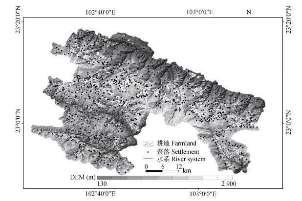
图1研究区区位与红河哈尼梯田耕地空间分布图
Figure1.Location of the study area and spatial distribution of the Honghe Hani Rice Terrace farmland
 下载: 全尺寸图片幻灯片
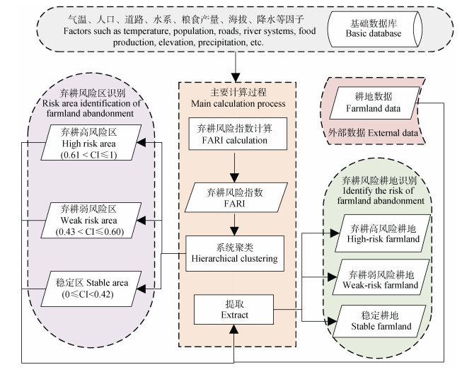
图2弃耕风险因子(FARI)计算和弃耕风险识别的主要过程
Figure2.Main processes of the calculation of farmland abandonment risk indexes (FARI) and identification of risk area of farmland abandonment
下载: 全尺寸图片幻灯片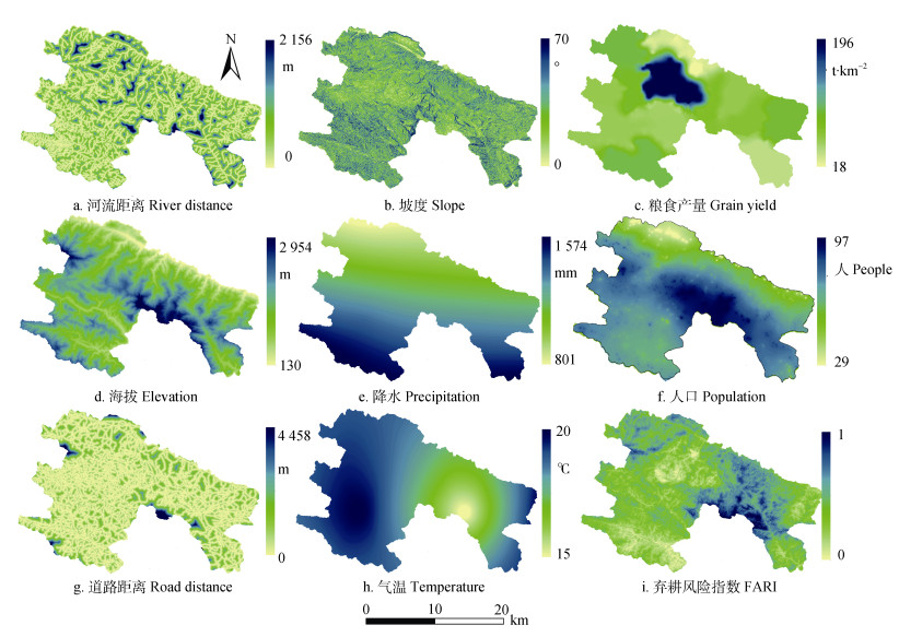
图3红河哈尼梯田弃耕风险识别因子和弃耕风险指数(FARI)的空间分布
Figure3.Spatial distribution of identification factors of risk of farmland abandonment and farmland abandonment risk index (FARI) of the Honghe Hani Rice Terraces
下载: 全尺寸图片幻灯片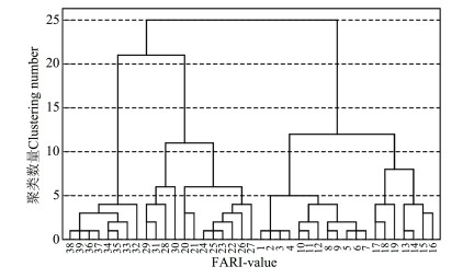
图4弃耕风险指数(FARI)的聚类结果
Figure4.Clustering results of abandoned farming risk index (FARI)
下载: 全尺寸图片幻灯片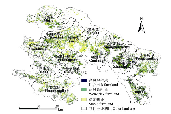
图5红河哈尼梯田不同程度潜在弃耕风险耕地识别
Figure5.Identification of different levels of potentially abandoned farmlands of the Honghe Hani Rice Terraces
下载: 全尺寸图片幻灯片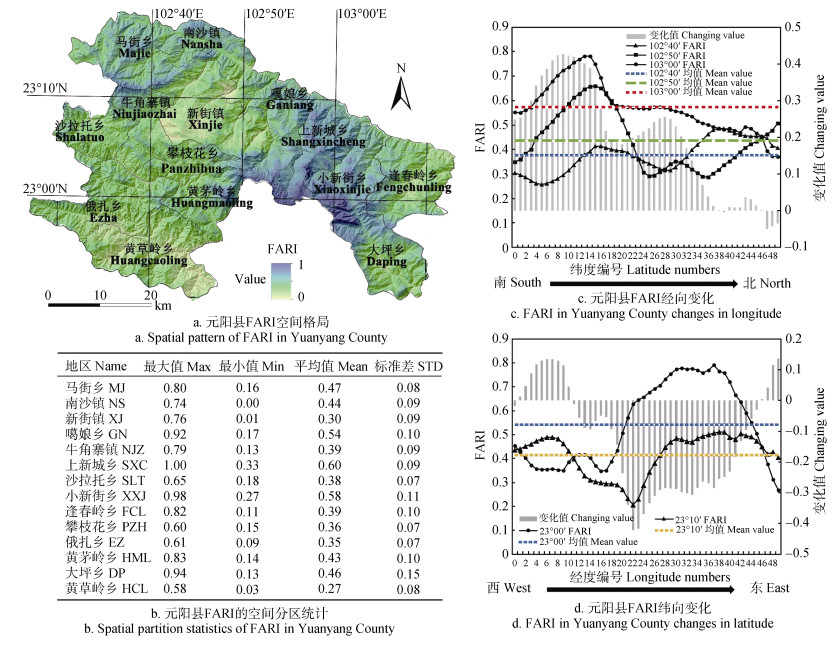
图6红河哈尼梯田弃耕风险指数(FARI)的空间格局与差异
Figure6.Spatial pattern and difference of abandoned farming risk index (FARI) of the Honghe Hani Rice Terraces
In the figure b, the English name of township is shown in the table 3.
下载: 全尺寸图片幻灯片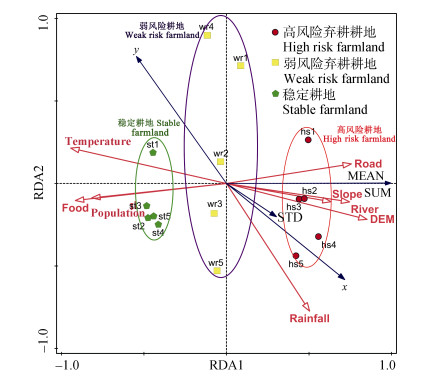
图7红河哈尼梯田弃耕风险指数与环境因子的RDA分析
Figure7.RDA analysis of farmland abandonment risk index and affecting factors in the Honghe Hani Rice Terraces
下载: 全尺寸图片幻灯片表1弃耕风险识别的主要数据来源及属性
Table1.Main data sources and attributes for farmland abandonment risk identification
| 数据Data | 类型Type | 分辨率Resolution | 时间Time | 数据来源Source |
| 水系River | Polyline | 1:10 000 | 2017 | 云南省地理国情普查数据库 Survey database of geographical conditions of Yunnan Province |
| 耕地Farmland | Polygon | 1:10 000 | ||
| 居民点Village point | Point | 1:10 000 | ||
| 道路Road | Polyline | 1:10 000 | ||
| 海拔Elevation | Raster | 10 m | ||
| 降水Rainfall | Raster | 0.1° | 多年平均值 Multi-year average | 中国科学院青藏高原研究所 Institute of Tibetan Plateau Research, Chinese Academy of Sciences |
| 气温Temperature | Raster | 0.1° | ||
| 人口Population | Excel | 自然村Village | 2016 | 元阳县统计局 Statistics Bureau of Yuanyang County |
| 粮食产量Grain yield | Excel | 乡镇Township and town |
下载: 导出CSV表2弃耕风险识别因子的确定依据与数据处理
Table2.Determining basis and data processing of identification factors of risk of farmland abandonment
| 因子 Factor | 与弃耕风险的关系 Relationship with risk of farming abandonment | 数据处理 Data processing | 指标来源 Source |
| 道路距离 Road distance | 农作物主要通过人与畜力运送, 距离道路远, 运输不便, 耕地弃耕风险.增大 Crops are mainly transported by humans and animal power, far from the road and inconvenient transport increased the risk of farmland abandonment. | 选取县道、乡道、村道、耕作道路数据, 进行欧式距离计算, 输出10 m×10 m栅格 The Euclidean distance is calculated with county roads, township roads, village roads, and farming road data to output a 10 m×10 m grid. | [15-18] |
| 水系距离 River distance | 梯田主要以水稻梯田为主, 灌溉水源是保证梯田生产的根本 The terraces are mainly rice terraces, and the irrigation water source is a necessary condition to ensure the production of terraces. | 选取水系数据, 计算欧式距离计算, 输出10 m×10 m栅格 The Euclidean distance is calculated with the river system to output a 10 m×10 m grid. | [21] |
| 海拔 Elevation | 哈尼梯田水稻生长具有严格的海拔线, 超过1 800 m水稻分布减少 Rice mainly is cultivated at area with altitude lower than 1 800 m. | 10 m×10 m栅格 10 m×10 m grid | [15-20] |
| 坡度Slope | 在山区, 坡度越大, 耕作难度越大 In mountainous areas, the greater the slope, the more difficult to cultivate | 根据海拔数据进行坡度计算输出10 m×10 m栅格 The slope is calculated with altitude data to output a 10 m × 10 m grid | [15, 19-22] |
| 降水 Precipitation | 梯田灌溉水源主要来自降水 Terraced irrigation water sources mainly come from precipitation | 多年平均处理后重采样为10 m×10 m的栅格 After multi-year average treatment, the grid is resampled to 10 m×10 m | [16, 26] |
| 气温 Temperature | 水稻的生长具有严格的热量要求 Rice growth has strict temperature requirements | 多年平均处理后重采样为10 m×10 m的栅格 After multi-year average treatment, the grid is resampled to 10 m×10 m | [16, 26] |
| 人口 Population | 传统的人工稻作农业, 需要大量的人口维持耕地生产 Traditional rice farming requires a large amount of labor to sustain farmland production | 自然村人口数值空间化后, 转为10 m×10 m的栅格 The population data is spatialized, and a grid of 10 m× 10 m is output | [15, 20-23] |
| 粮食产量 Grain yield | 粮食产量越高, 耕地肥力越好, 弃耕风险越小 The higher the grain output and the better the fertility of the farmland, the lower the risk of abandoned farming is. | 数值空间化后, 转为10 m×10 m的栅格 Outputting 10 m × 10 m grid through numerical spatialization | [24, 26-28] |
下载: 导出CSV表3乡镇尺度下红河哈尼梯田耕地弃耕风险面积
Table3.Risk area of abandoned farmland under the township scale of the Honghe Hani Rice Terraces
| 乡镇 Township | 区域面积 Area of region (km2) | 耕地面积 Farmland area (km2) | 高风险耕地占比 High risk farmland proportion (%) | 弱风险耕地占比 Weak risk farmland proportion (%) | 稳定耕地占比 Stable farmland proportion (%) |
| 马街乡Majie (MJ) | 201.64 | 32.45 | 3.20 | 37.26 | 59.54 |
| 南沙镇Nansha (NS) | 170.50 | 6.94 | 0.09 | 28.79 | 71.12 |
| 新街镇Xinjie (XJ) | 224.59 | 69.68 | 0.01 | 10.52 | 89.47 |
| 嘎娘乡Ganiang (GN) | 131.59 | 21.43 | 9.43 | 40.46 | 50.12 |
| 牛角寨镇Niujiaozhai (NJZ) | 118.90 | 32.34 | 3.62 | 29.65 | 66.73 |
| 上新城乡Shangxincheng (SXC) | 146.47 | 29.06 | 18.89 | 42.57 | 38.54 |
| 沙拉托乡Shalatuo (SLT) | 100.82 | 24.97 | 5.89 | 32.96 | 61.15 |
| 小新街乡Xiaoxinjie (XXJ) | 127.70 | 29.55 | 18.00 | 45.96 | 36.04 |
| 逢春岭乡Fengchunling (FCL) | 181.65 | 34.99 | 3.97 | 48.41 | 47.61 |
| 攀枝花乡Panzhihua (PZH) | 75.95 | 20.57 | 4.13 | 31.79 | 64.07 |
| 俄扎乡Ezha (EZ) | 209.31 | 26.21 | 22.82 | 43.38 | 33.80 |
| 黄茅岭乡Huangmaoling (HML) | 117.47 | 16.01 | 15.49 | 46.47 | 38.04 |
| 大坪乡Daping (DP) | 179.06 | 30.22 | 20.02 | 46.10 | 33.88 |
| 黄草岭乡Huangcaoling (HCP) | 229.32 | 39.04 | 3.66 | 39.16 | 57.17 |
| 合计Total | 2 215.04 | 413.47 | 8.39 | 35.16 | 56.45 |
下载: 导出CSV表4红河哈尼梯田不同弃耕风险程度下的影响因子值
Table4.Values of affecting factors of farmlands with different risk levels of farmland abandonment in the Honghe Hani Rice Terraces
| 弃耕风险程度 Risk level of farmland abandonment | 海 拔Elevation (m) | 坡度 Slope (°) | 道路距离 Road distance (m) | 降水 Precipitation (mm) | 粮食产量 Grain yield (t·km-2) | 气温 Temperature (℃) | 人口 Population (persons) | 水系距离 River distance (m) |
| 稳定Stable | 1 242.90 | 18.41 | 165.32 | 1 178.61 | 108.59 | 18.69 | 489.25 | 264.95 |
| 弱风险Weak risk | 1 235.98 | 23.16 | 195.82 | 1 227.36 | 82.02 | 18.51 | 419.32 | 272.73 |
| 高风险High risk | 1 364.61 | 28.80 | 235.43 | 1 268.67 | 69.02 | 18.15 | 334.73 | 314.48 |
下载: 导出CSV表5红河哈尼梯田各识别因子对弃耕风险指数(FARI)的贡献率
Table5.Contribution rate of each affecting factor on the farmland abandonment risk index (FARI) in the Honghe Hani Rice Terraces
| 因子Factor | 解释度 Explain degree (%) | 贡献率 Contribution rate (%) | F | P |
| 气温Temperature | 88.4 | 88.9 | 99.0 | 0.002 |
| 粮食产量Grain yield | 7.9 | 8.0 | 25.6 | 0.004 |
| 海拔Elevation | 2.2 | 2.2 | 15.2 | 0.004 |
| 降水Precipitation | 0.7 | 0.7 | 7.3 | 0.020 |
| 人口Population | 0.2 | 0.2 | 2.3 | 0.138 |
| 坡度Slope | < 0.1 | < 0.1 | 0.6 | 0.508 |
| 水系距离River distance | < 0.1 | < 0.1 | 0.2 | 0.670 |
| 道路距离Road distance | < 0.1 | < 0.1 | 0.2 | 0.700 |
下载: 导出CSV参考文献
| [1] | LIU Y S, LI Y H. Revitalize the world's countryside[J]. Nature, 2017, 548(7667):275-277 doi: 10.1038/548275a |
| [2] | KAUPPI P E, AUSUBEL J H, FANG J Y, et al. Returning forests analyzed with the forest identity[J]. Proceedings of the National Academy of Sciences of the United States of America, 2006, 103(46):17574-17579 doi: 10.1073/pnas.0608343103 |
| [3] | ROMERO-CALCERRADA R, PERRY G L W. The role of land abandonment in landscape dynamics in the SPA'Encinares del río Alberche y Cofio, Central Spain, 1984-1999[J]. Landscape and Urban Planning, 2004, 66(4):217-232 doi: 10.1016/S0169-2046(03)00112-9 |
| [4] | POYATOS R, LATRON J, LLORENS P. Land use and land cover change after agricultural abandonment[J]. Mountain Research and Development, 2003, 23(4):362-368 doi: 10.1659/0276-4741(2003)023[0362:LUALCC]2.0.CO;2 |
| [5] | FOLEY J A, RAMANKUTTY N, BRAUMAN K A, et al. Solutions for a cultivated planet[J]. Nature, 2011, 478(7369):337-342 doi: 10.1038/nature10452 |
| [6] | LAMBIN E F, MEYFROIDT P. Global land use change, economic globalization, and the looming land scarcity[J]. Proceedings of the National Academy of Sciences of the United States of America, 2011, 108(9):3465-3472 doi: 10.1073/pnas.1100480108 |
| [7] | POINTEREAU P, COULON F, GIRARD P, et al. Analysis of Farmland Abandonment and the Extent and Location of Agricultural Areas that are Actually Abandoned or are in Risk to be Abandoned[R]. Ispra: Institute for Environment and Sustainability, 2008 |
| [8] | CORBELLE-RICO E, CRECENTE-MASEDA R. Evaluating IRENA indicator "Risk of farmland abandonment" on a low spatial scale level:the case of Galicia (Spain)[J]. Land Use Policy, 2014, 38:9-15 doi: 10.1016/j.landusepol.2013.10.013 |
| [9] | BAUMANN M, KUEMMERLE T, ELBAKIDZE M, et al. Patterns and drivers of post-socialist farmland abandonment in Western Ukraine[J]. Land Use Policy, 2011, 28(3):552-562 doi: 10.1016/j.landusepol.2010.11.003 |
| [10] | YIN H, PRISHCHEPOV A V, KUEMMERLE T, et al. Mapping agricultural land abandonment from spatial and temporal segmentation of Landsat time series[J]. Remote Sensing of Environment, 2018, 210:12-24 doi: 10.1016/j.rse.2018.02.050 |
| [11] | ALCANTARA C, KUEMMERLE T, PRISHCHEPOV A V, et al. Mapping abandoned agriculture with multi-temporal MODIS satellite data[J]. Remote Sensing of Environment, 2012, 124:334-347 doi: 10.1016/j.rse.2012.05.019 |
| [12] | L?W F, PRISHCHEPOV A, WALDNER F, et al. Mapping cropland abandonment in the Aral sea basin with MODIS time series[J]. Remote Sensing, 2018, 10(2):159 doi: 10.3390/rs10020159 |
| [13] | KEENLEYSIDE C, TUCKER G. Farmland Abandonment in the EU: An Assessment of Trends and Prospects[R]. Report Prepared for WWF. London: Institute for European Environmental Policy, 2010 |
| [14] | 金芳芳, 辛良杰.中国闲置耕地的区域分布及影响因素研究[J].资源科学, 2018, 40(4):719-728 http://d.old.wanfangdata.com.cn/Periodical/zykx201804006 JIN F F, XLN L J. Spatial distribution and impact factors of farmland abandonment[J]. Resources Science, 2018, 40(4):719-728 http://d.old.wanfangdata.com.cn/Periodical/zykx201804006 |
| [15] | VIDAL-MACUA J J, NINYEROLA M, ZABALA A, et al. Environmental and socioeconomic factors of abandonment of rainfed and irrigated crops in Northeast Spain[J]. Applied Geography, 2018, 90:155-174 doi: 10.1016/j.apgeog.2017.12.005 |
| [16] | WANG H L, QIU F, RUAN X F. Loss or gain:A spatial regression analysis of switching land conversions between agriculture and natural land[J]. Agriculture, Ecosystems & Environment, 2016, 221:222-234 |
| [17] | PRISHCHEPOV A V, MüLLER D, DUBININ M, et al. Determinants of agricultural land abandonment in Post-Soviet European Russia[J]. Land Use Policy, 2013, 30(1):873-884 doi: 10.1016/j.landusepol.2012.06.011 |
| [18] | MOTTET A, LADET S, COQUé N, et al. Agricultural land-use change and its drivers in mountain landscapes:A case study in the Pyrenees[J]. Agriculture, Ecosystems & Environment, 2006, 114(2/3/4):296-310 doi: 10.1016-j.agee.2005.11.017/ |
| [19] | YU Z L, LIU L, ZHANG H, et al. Exploring the factors driving seasonal farmland abandonment:A case study at the regional level in Hunan Province, Central China[J]. Sustainability, 2017, 9(2):187 doi: 10.3390/su9020187 |
| [20] | SHI T C, LI X B, XIN L J, et al. The spatial distribution of farmland abandonment and its influential factors at the township level:A case study in the mountainous area of China[J]. Land Use Policy, 2018, 70:510-520 doi: 10.1016/j.landusepol.2017.10.039 |
| [21] | PAZúR R, LIESKOVSKY J, FERANEC J, et al. Spatial determinants of abandonment of large-scale arable lands and managed grasslands in Slovakia during the periods of post-socialist transition and European Union accession[J]. Applied Geography, 2014, 54:118-128 doi: 10.1016/j.apgeog.2014.07.014 |
| [22] | KOLECKA N, KOZAK J, KAIM D, et al. Understanding farmland abandonment in the Polish Carpathians[J]. Applied Geography, 2017, 88:62-72 doi: 10.1016/j.apgeog.2017.09.002 |
| [23] | 张佰林, 杨庆媛, 严燕, 等.快速城镇化进程中不同类型农户弃耕特点及原因——基于重庆市十区县540户农户调查[J].资源科学, 2011, 33(11):2047-2054 http://www.wanfangdata.com.cn/details/detail.do?_type=perio&id=zykx201111005 ZHANG B L, YANG Q Y, YAN Y, et al. Characteristics and reasons of different households' farming abandonment behavior in the process of rapid urbanization based on a survey from 540 households in 10 counties of Chongqing municipality[J]. Resources Science, 2011, 33(11):2047-2054 http://www.wanfangdata.com.cn/details/detail.do?_type=perio&id=zykx201111005 |
| [24] | ZHANG Y, LI X B, SONG W, et al. Land abandonment under rural restructuring in China explained from a cost-benefit perspective[J]. Journal of Rural Studies, 2016, 47:524-532 doi: 10.1016/j.jrurstud.2016.06.019 |
| [25] | XIE H L, WANG P, YAO G R. Exploring the dynamic mechanisms of farmland abandonment based on a spatially explicit economic model for environmental sustainability:A case study in Jiangxi Province, China[J]. Sustainability (Switzerland), 2014, 6(3):1260-1282 doi: 10.3390/su6031260 |
| [26] | ZHANG Y, LI X B, SONG W. Determinants of cropland abandonment at the parcel, household and village levels in mountain areas of China:A multi-level analysis[J]. Land Use Policy, 2014, 41:186-192 doi: 10.1016/j.landusepol.2014.05.011 |
| [27] | 崔悦, 赵凯, 贺婧, 等.水稻优生区农户资本禀赋对其耕地保护决策行为的影响——基于双栏模型的实证研究[J].中国生态农业学报(中英文), 2019, 27(6):959-970 http://www.ecoagri.ac.cn/zgstny/ch/reader/view_abstract.aspx?flag=1&file_no=2019-0615&journal_id=zgstny CUI Y, ZHAO K, HE J, et al. Effect of capital endowment on Farmers' decision-making in protecting cultivated land in a rice-growing area:An empirical study based on a double-hurdle model[J]. Chinese Journal of Eco-Agriculture, 2019, 27(6):959-970 http://www.ecoagri.ac.cn/zgstny/ch/reader/view_abstract.aspx?flag=1&file_no=2019-0615&journal_id=zgstny |
| [28] | 彭继权, 吴海涛, 宋嘉豪, 等.农业机械化水平对湖北农户耕地复种指数的影响[J].中国生态农业学报(中英文), 2019, 27(3):380-390 http://www.ecoagri.ac.cn/zgstny/ch/reader/view_abstract.aspx?flag=1&file_no=2019-0305&journal_id=zgstny PENG J Q, WU H T, SONG J H, et al. Impact of agricultural mechanization level on farmers' cropping index in Hubei Province[J]. Chinese Journal of Eco-Agriculture, 2019, 27(3):380-390 http://www.ecoagri.ac.cn/zgstny/ch/reader/view_abstract.aspx?flag=1&file_no=2019-0305&journal_id=zgstny |
| [29] | 胡伟芳, 张永勋, 王维奇, 等.联合梯田农业文化遗产地景观特征与景观资源利用[J].中国生态农业学报, 2017, 25(12):1752-1760 http://d.old.wanfangdata.com.cn/Periodical/stnyyj201712003 HU W F, ZHANG Y X, WANG W Q, et al. Landscape characteristics and utilization in agro-cultural heritage systems in Lianhe Terrace[J]. Chinese Journal of Eco-Agriculture, 2017, 25(12):1752-1760 http://d.old.wanfangdata.com.cn/Periodical/stnyyj201712003 |
