肖轶1,
孙思琦1,
郭泺1,,
1.中央民族大学生命与环境科学学院 北京 100081
2.北京大学城市与环境学院 北京 100871
基金项目: 科技部重点研发计划课题2017YFC0505601
详细信息
作者简介:陈奕竹, 主要从事景观生态学研究。E-mail:baggieChen@126.com
通讯作者:郭泺, 主要从事景观生态学研究。E-mail:guoluo@muc.edu.cn
中图分类号:S181计量
文章访问数:699
HTML全文浏览量:4
PDF下载量:739
被引次数:0
出版历程
收稿日期:2018-08-08
录用日期:2018-12-03
刊出日期:2019-04-01
Spatial-temporal changes of ecosystem service values in Xiangxi region based on terrain
CHEN Yizhu1, 2,,XIAO Yi1,
SUN Siqi1,
GUO Luo1,,
1. College of Life and Environmental Sciences, Minzu University of China, Beijing 100081, China
2. College of Urban and Environmental Sciences, Peking University, Beijing 100871, China
Funds: the Key Research and Development Project of Chinese Ministry of Science and Technology2017YFC0505601
More Information
Corresponding author:E-mail:guoluo@muc.edu.cn
摘要
HTML全文
图
参考文献
相关文章
施引文献
资源附件
访问统计
摘要
摘要:为探究土地利用和生态系统服务价值(ecosystem service value,ESV)随不同地形因子变化的情况,本文利用湘西地区1990年、1995年、2000年、2005年、2010年及2015年6期遥感数据、野外调研数据和统计数据,分析了湘西不同土地利用类型在不同地形梯度上的变化、生态系统服务价值的时空变化及土地利用格局与ESV的相关性。研究结果表明:1)受人类活动影响较大的土地利用类型如耕地和建设用地主要分布在较低高度及坡度梯度上,山体南面和东面方向各类型土地面积较大。林地在不同地形梯度上均为最主要的土地利用类型。建设用地面积在不同地形梯度上随时间均明显呈增加趋势。2)ESV在海拔梯度上表现为先减少后增加,且海拔越高,ESV随时间变化的增长幅度越小;ESV随坡度增大而增大,且25年间最小坡度梯度上增长量最多;ESV随着地形位指数上升而增大;坡向变化中,东南方向出现ESV最低值,西北方向出现ESV最高值,东和西北方向ESV随时间增长量最大。3)相关性分析表明,林地、草地在坡度和地形位梯度上的变化与ESV变化呈正相关。湘西地区土地利用变化及生态系统服务价值随地形变化的差异明显。本研究为合理布局和保护我国南方丘陵山地区域的生态用地,发挥湘西地区的生态屏障作用提供了理论依据和决策支持。
关键词:土地利用变化/
生态系统服务价值/
地形梯度/
地形位指数/
湘西地区
Abstract:To understand the change of land use and ecosystem service value (ESV) on different terrain gradients, this study used remote sensing data, field data and statistic data of Xiangxi region in 1990, 1995, 2000, 2005, 2010 and 2015 to analyze the change of each land use types along the gradients of elevation, slope, aspect and terrain index, which were classified into five levels by quantile method, respectively. The study also evaluated the ESV with XIE Gaodi's method to explore the spatio-temporal change of ESV in Xiangxi region. And R Studio and Pearson correlations were used to analyze correlation between areas changes of different land use types and change of ESV with terrain gradients. The results showed that:1) areas of different land use types were significantly different on different terrain gradients. The human-activity-affected cropland and construction land mainly distributed on low gradients of elevation, slope and terrain index, while the natural systems, such as forestland and grassland, were mainly on high gradients of the three terrain factors. The south and east slopes were with larger areas of each land use type. Forestland occupied about 70% area on every terrain gradient, and the construction land area significantly increased on every terrain gradient over 25 years. 2) ESV decreased first and then increased with increasing elevation. From 1990 to 2015, ESV increased at lower elevation gradient, however, change was slighter at higher elevation, and it even decreased on the highest elevation gradient. ESV increased with slope growth. Over 25 years, ESV increased most on the lowest slope gradient. In a similar way, ESV evenly increased with increasing terrain index gradient. ESV was the lowest in southeast slope, highest in northwest slope, and increased most in east and northwest slopes from 1990 to 2015. 3) Correlations between change of land use types areas and ESV with gradients of elevation, slope, aspect, terrain index were different. On elevation gradient, grassland area change significantly positively correlated with ESV change. On slope gradient, forestland and grassland areas changes both had extremely positive correlation with ESV change. On aspect gradient, cropland and unused land areas changes had extremely negative correlation with ESV change, while forestland had a significant positive correlation. On terrain index gradient, areas changes of forestland and grassland were significantly correlated with change of ESV. In summary, the changes of land use and ESV were obviously different regarding topography. Forestland and grassland were two important land use types for improvement of ESV in mountain area of Xiangxi region.
Key words:Land use change/
Ecosystem service value/
Terrain gradient/
Terrain index/
Xiangxi region
HTML全文
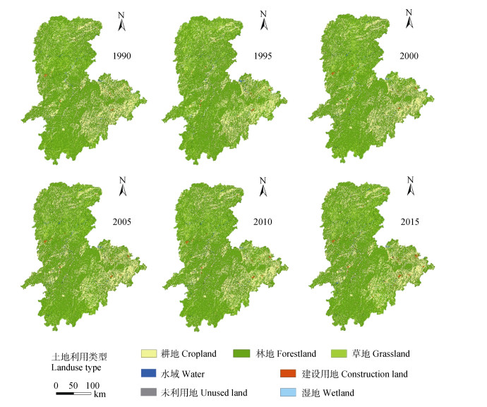
图11990—2015年湘西地区土地利用类型图
Figure1.Maps of land use in Xiangxi region from 1990 to 2015
 下载: 全尺寸图片幻灯片
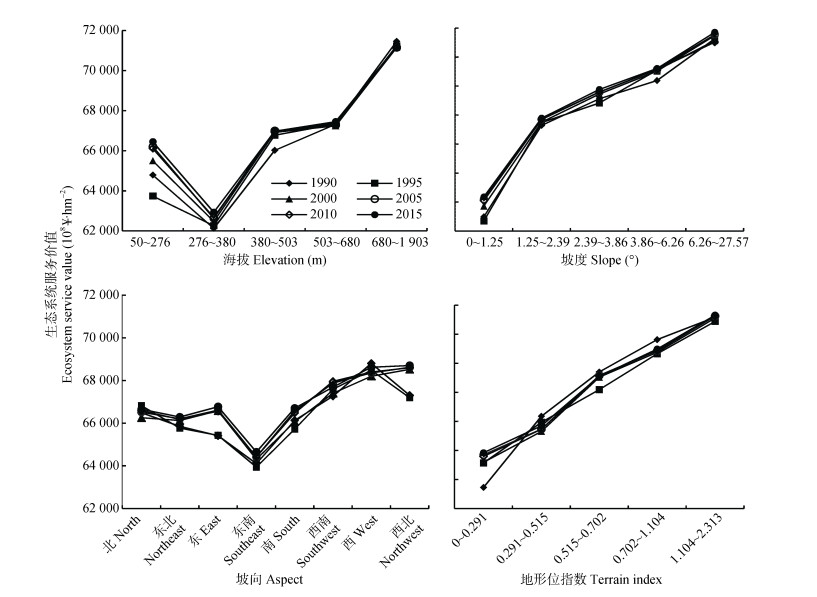
图2湘西地区随海拔、坡度、坡向、地形位指数梯度变化的生态系统服务价值
Figure2.Changes of ecosystem service values with elevation, slope, aspect, terrain index gradients in Xiangxi region
下载: 全尺寸图片幻灯片表1湘西地区海拔、坡度、坡向及地形位梯度设置情况
Table1.Gradients of elevation, slope, aspect and topographic index setting in Xiangxi region
| 海拔Elevation | 坡度Slope | 坡向Aspect | 地形位Terrain index | |||||||
| 梯度等级 Gradient | 梯度范围 Gradient range (m) | 梯度等级 Gradient | 梯度范围 Gradient range (°) | 梯度等级 Gradient | 梯度范围 Gradient range (°) | 梯度等级 Gradient | 梯度范围 Gradient range | |||
| 1 | 50~276 | 1 | 0~1.25 | 北North | 0~22.5 & 337.5~360 | 1 | 0~0.291 | |||
| 2 | 276~380 | 2 | 1.25~2.39 | 东北Northeast | 22.5~67.5 | 2 | 0.291~0.515 | |||
| 3 | 380~503 | 3 | 2.39~3.86 | 东East | 67.5~112.5 | 3 | 0.515~0.702 | |||
| 4 | 503~680 | 4 | 3.86~6.26 | 东南Southeast | 112.5~157.5 | 4 | 0.702~1.104 | |||
| 5 | 680~1 903 | 5 | 6.26~27.57 | 南South | 157.5~202.5 | 5 | 1.104~2.313 | |||
| 西南Southwest | 202.5~247.5 | |||||||||
| 西West | 247.5~292.5 | |||||||||
| 西北Northwest | 292.5~337.5 | |||||||||
下载: 导出CSV表2梯度变化的土地利用面积与地形梯度变化的生态系统服务价值相关性系数
Table2.Correlation coefficients between changes in land use area and ecosystem services value with terrain gradient change in Xiangxi region
| 地形因素Terrain factor | 土地利用面积变化Change in land use area | ||||||
| 耕地 Cropland | 林地 Forest | 草地 Grassland | 未利用地 Unused land | 水域 Water | 湿地 Wetland | ||
| 生态系统服务价值变化Change in ecosystem service value | 海拔梯度Elevation gradient | -0.763 | 0.632 | 0.938* | -0.561 | -0.481 | -0.598 |
| 坡度梯度Slope gradient | -0.997** | 0.994** | 0.958* | -0.180 | -0.989** | -0.941* | |
| 坡向梯度Aspect gradient | -0.888** | 0.842** | 0.598 | -0.828* | -0.570 | -0.295 | |
| 地形位梯度Terrain index gradient | -0.975** | 0.946* | 0.996** | -0.696 | -0.896* | -0.803 | |
| *0.05水平(双侧)显著相关。相关系数0.8~1.0为极强相关、0.6~0.8为强相关、0.4~0.6为中等相关、0.2~0.4为弱相关、0~0.2为极弱相关或不相关。* represents significant correlation at 0.05 level (both sides). Correlation coefficient of 0.8-1.0 represents extremely strong correlation, 0.6-0.8 represents strong correlation, 0.4-0.6 represents medium correlation, 0.2-0.4 represents weak correlation, 0-0.2 represents extremely weak correlation or non-correlation. | |||||||
下载: 导出CSV参考文献
| [1] | 欧阳志云, 王效科, 苗鸿.中国陆地生态系统服务功能及其生态经济价值的初步研究[J].生态学报, 1999, 19(5):607-613 doi: 10.3321/j.issn:1000-0933.1999.05.004 OUYANG Z Y, WANG X K, MIAO H. A primary study on Chinese terrestrial ecosystem services and their ecological-economic values[J]. Acta Ecologica Sinica, 1999, 19(5):607-613 doi: 10.3321/j.issn:1000-0933.1999.05.004 |
| [2] | 陈蝶, 卫伟, 陈利顶, 等.梯田生态系统服务与管理研究进展[J].山地学报, 2016, 34(3):374-384 http://d.old.wanfangdata.com.cn/Periodical/sdxb201603016 CHEN D, WEI W, CHEN L D, et al. Progress of the ecosystem services and management of terraces[J]. Mountain Research, 2016, 34(3):374-384 http://d.old.wanfangdata.com.cn/Periodical/sdxb201603016 |
| [3] | 谢高地, 甄霖, 鲁春霞, 等.一个基于专家知识的生态系统服务价值化方法[J].自然资源学报, 2008, 23(5):911-919 doi: 10.3321/j.issn:1000-3037.2008.05.019 XIE G D, ZHEN L, LU C X, et al. Expert knowledge based valuation method of ecosystem services in China[J]. Journal of Natural Resources, 2008, 23(5):911-919 doi: 10.3321/j.issn:1000-3037.2008.05.019 |
| [4] | 谢高地, 张彩霞, 张雷明, 等.基于单位面积价值当量因子的生态系统服务价值化方法改进[J].自然资源学报, 2015, 30(8):1243-1254 XIE G D, ZHANG C X, ZHANG L M, et al. Improvement of the evaluation method for ecosystem service value based on per unit area[J]. Journal of Natural Resources, 2015, 30(8):1243-1254 |
| [5] | 张艳军, 官冬杰, 翟俊, 等.重庆市生态系统服务功能价值时空变化研究[J].环境科学学报, 2017, 37(3):1169-1177 http://d.old.wanfangdata.com.cn/Periodical/hjkxxb201703044 ZHANG Y J, GUAN D J, ZHAI J, et al. Spatial and temporal variations of ecosystem services value in Chongqing City[J]. Acta Scientiae Circumstantiae, 2017, 37(3):1169-1177 http://d.old.wanfangdata.com.cn/Periodical/hjkxxb201703044 |
| [6] | 游巍斌, 何东进, 巫丽芸, 等.山岳旅游地生态服务价值时空分异及其与环境因子关系——以武夷山风景名胜区为例[J].山地学报, 2012, 30(1):113-120 doi: 10.3969/j.issn.1008-2786.2012.01.017 YOU W B, HE D J, WU L Y, et al. Spatial-temporal variation of landscape service value and its correlation with ambient environmental factors in mountain resorts-A case study of Wuyishan Scenery District[J]. Journal of Mountain Science, 2012, 30(1):113-120 doi: 10.3969/j.issn.1008-2786.2012.01.017 |
| [7] | 满苏尔·沙比提, 娜斯曼·那斯尔丁, 艾萨迪拉·玉苏甫.天山托木尔峰国家级自然保护区生态系统服务价值评估[J].山地学报, 2016, 34(5):599-605 http://d.old.wanfangdata.com.cn/Periodical/sdxb201605011 SABIT M, NASIRDIN N, YUSUP A. Evaluation on ecosystem service value of Tianshan Tomur National Nature Reserve[J]. Mountain Research, 2016, 34(5):599-605 http://d.old.wanfangdata.com.cn/Periodical/sdxb201605011 |
| [8] | MA (Millennium Ecosystem Assessment). Ecosystems and Human Well-Being: Current State and Trends: Synthesis[M]. Washington, DC: Island Press, 2005 |
| [9] | 李敏.基于土地利用变化的生态系统服务价值研究——来自2000-2013年淮南市土地利用的经验证据[D].合肥: 合肥工业大学, 2015 LI M. Study on ecosystem services value based on land use change-Empirical evidence from Huainan City during 2000-2013[D]. Hefei: Hefei University of Technology, 2015 |
| [10] | 王盼盼.东北区县域土地利用景观格局演变及驱动机制研究[D].哈尔滨: 东北农业大学, 2015 WANG P P. Study on the county's landscape pattern change characteristics and its driving mechanism in the Northeast China[D]. Harbin: Northeast Agricultural University, 2015 |
| [11] | 顾泽贤, 赵筱青, 高翔宇, 等.澜沧县景观格局变化及其生态系统服务价值评价[J].生态科学, 2016, 35(5):143-153 http://www.cnki.com.cn/Article/CJFDTOTAL-STKX201605020.htm GU Z X, ZHAO X Q, GAO X Y, et al. Change of landscape pattern and it's evaluation of ecosystem services values in Lancang County[J]. Ecological Science, 2016, 35(5):143-153 http://www.cnki.com.cn/Article/CJFDTOTAL-STKX201605020.htm |
| [12] | 刘桂林, 张落成, 张倩.长三角地区土地利用时空变化对生态系统服务价值的影响[J].生态学报, 2014, 34(12):3311-3319 http://d.old.wanfangdata.com.cn/Periodical/stxb201412019 LIU G L, ZHANG L C, ZHANG Q. Spatial and temporal dynamics of land use and its influence on ecosystem service value in Yangtze River Delta[J]. Acta Ecologica Sinica, 2014, 34(12):3311-3319 http://d.old.wanfangdata.com.cn/Periodical/stxb201412019 |
| [13] | 蔺小虎, 姚顽强, 邱春霞.黄土丘陵沟壑区退耕驱动下土地利用变化——以陕西省安塞县纸坊沟流域为例[J].山地学报, 2015, 33(6):759-769 http://d.old.wanfangdata.com.cn/Periodical/sdxb201506014 LIN X H, YAO W Q, QIU C X. Land use change driven by farmland in loess hilly-gully region-A case study of Zhifanggou gully basin[J]. Mountain Research, 2015, 33(6):759-769 http://d.old.wanfangdata.com.cn/Periodical/sdxb201506014 |
| [14] | 王晓峰, 薛亚永, 张园.基于地形梯度的陕西省生态系统服务价值评估[J].冰川冻土, 2016, 38(5):1432-1439 http://d.old.wanfangdata.com.cn/Periodical/bcdt201605030 WANG X F, XUE Y Y, ZHANG Y. Assessing the ecosystem service values in Shaanxi Province based on terrain[J]. Journal of Glaciology and Geocryology, 2016, 38(5):1432-1439 http://d.old.wanfangdata.com.cn/Periodical/bcdt201605030 |
| [15] | 朱昌丽, 张继飞, 赵宇鸾, 等.青藏高原东缘典型流域生态系统服务的地形梯度效应——以岷江上游为例[J].长江流域资源与环境, 2017, 26(10):1687-1699 ZHU C L, ZHANG J F, ZHAO Y L, et al. Topographic gradient effects of typical watershed ecosystem services in the eastern Tibetan Plateau-A case study of the upper reaches of Minjiang River[J]. Resources and Environment in the Yangtze Basin, 2017, 26(10):1687-1699 |
| [16] | 邹月, 周忠学.西安市景观格局演变对生态系统服务价值的影响[J].应用生态学报, 2017, 28(8):2629-2639 http://d.old.wanfangdata.com.cn/Periodical/yystxb201708027 ZOU Y, ZHOU Z X. Impact of landscape pattern change on ecosystem service value of Xi'an City, China[J]. Chinese Journal of Applied Ecology, 2017, 28(8):2629-2639 http://d.old.wanfangdata.com.cn/Periodical/yystxb201708027 |
| [17] | 李全, 李腾, 杨明正, 等.基于梯度分析的武汉市生态系统服务价值时空分异特征[J].生态学报, 2017, 37(6):2118-2125 http://d.old.wanfangdata.com.cn/Periodical/stxb201706037 LI Q, LI T, YANG M Z, et al. Spatiotemporal variation of ecosystem services value based on gradient analysis in Wuhan:2000-2010[J]. Acta Ecologica Sinica, 2017, 37(6):2118-2125 http://d.old.wanfangdata.com.cn/Periodical/stxb201706037 |
| [18] | 郜红娟, 韩会庆, 罗绪强, 等.贵州省生态系统服务价值与社会经济空间相关性分析[J].水土保持研究, 2016, 23(2):262-266 http://d.old.wanfangdata.com.cn/Periodical/stbcyj201602048 GAO H J, HAN H Q, LUO X Q, et al. Spatial correlation of socioeconomic factors and ecosystem service values in Guizhou Province[J]. Research of Soil and Water Conservation, 2016, 23(2):262-266 http://d.old.wanfangdata.com.cn/Periodical/stbcyj201602048 |
| [19] | 陈婧祎, 罗红霞, 胡林利, 等.生态系统服务价值与社会经济相关性研究——以重庆市大都市区为例[J].水土保持研究, 2017, 24(4):330-336 CHEN J Y, LUO H X, HU L L, et al. Correlation between social economic development and ecosystem service value-A case of Chongqing metropolitan area[J]. Research of Soil and Water Conservation, 2017, 24(4):330-336 |
| [20] | 陈青峰, 于化龙, 张杰, 等.怀来县土地利用/覆被变化及生态系统服务价值时空演变[J].水土保持研究, 2016, 23(3):137-143 http://www.cnki.com.cn/Article/CJFDTOTAL-STBY201603025.htm CHEN Q F, YU H L, ZHANG J, et al. The spatiotemporal evolution of land use/cover change and ecosystem service values in Huailai County[J]. Research of Soil and Water Conservation, 2016, 23(3):137-143 http://www.cnki.com.cn/Article/CJFDTOTAL-STBY201603025.htm |
| [21] | 郜红娟, 张朝琼, 张凤太.基于地形梯度的贵州省土地利用时空变化分析[J].四川农业大学学报, 2015, 33(1):62-70 http://d.old.wanfangdata.com.cn/Periodical/scnydxxb201501011 GAO H J, ZHANG C Q, ZHANG F T. Spatio-temporal patterns of land use change in Guizhou Province based on terrain gradient[J]. Journal of Sichuan Agricultural University, 2015, 33(1):62-70 http://d.old.wanfangdata.com.cn/Periodical/scnydxxb201501011 |
| [22] | 董顺舟, 赵宇鸾, 李秀彬.基于地形梯度的高原山地区土地利用格局时空特征——以贵州省盘县为例[J].水土保持研究, 2017, 24(2):213-222 DONG S Z, ZHAO Y L, LI X B. Spatiotemporal patterns of land use change in plateau region based on the terrain gradient-A case study in Panxian County[J]. Research of Soil and Water Conservation, 2017, 24(2):213-222 |
| [23] | 吴见, 王帅帅, 谭靖.基于安徽省土地利用变化的地形梯度效应分析[J].长江流域资源与环境, 2016, 25(2):239-248 http://d.old.wanfangdata.com.cn/Periodical/cjlyzyyhj201602009 WU J, WANG S S, TAN J. Analysis on terrain gradient effect based on land use change in Anhui Province[J]. Resources and Environment in the Yangtze Basin, 2016, 25(2):239-248 http://d.old.wanfangdata.com.cn/Periodical/cjlyzyyhj201602009 |
| [24] | 杨锁华, 胡守庚, 瞿诗进.长江中游地区生态系统服务价值的地形梯度效应[J].应用生态学报, 2018, 29(3):976-986 http://www.cnki.com.cn/Article/CJFDTOTAL-YYSB201803037.htm YANG S H, HU S G, QU S J. Terrain gradient effect of ecosystem service value in middle reach of Yangtze River, China[J]. Chinese Journal of Applied Ecology, 2018, 29(3):976-986 http://www.cnki.com.cn/Article/CJFDTOTAL-YYSB201803037.htm |
| [25] | 许策, 李超, 张天柱, 等.基于地形梯度的河北省怀来县山地生态系统空间分布及变化特征分析[J].水土保持通报, 2017, 37(5):198-204 http://d.old.wanfangdata.com.cn/Periodical/stbctb201705033 XU C, LI C, ZHANG T Z, et al. Distribution and variation analysis of mountain ecosystem based on topographic gradient in Huailai County of Hebei Province[J]. Bulletin of Soil and Water Conservation, 2017, 37(5):198-204 http://d.old.wanfangdata.com.cn/Periodical/stbctb201705033 |
| [26] | 湖南省统计局. 2016湖南统计年鉴[M].北京: 中国统计出版社, 2016 Hunan Provincial Bureau of Statistics. 2016 Hunan Statistical Yearbook[M]. Beijing: China Standard Press, 2016 |
| [27] | 哈凯, 丁庆龙, 门明新, 等.山地丘陵区土地利用分布及其与地形因子关系——以河北省怀来县为例[J].地理研究, 2015, 34(5):909-921 HA K, DING Q L, MEN M X, et al. Spatial distribution of land use and its relationship with terrain factors in hilly area[J]. Geographical Research, 2015, 34(5):909-921 |
| [28] | 赵艳霞, 武爱彬, 刘欣, 等.浅山丘陵区土地利用地形梯度特征与生态服务价值响应[J].水土保持研究, 2014, 21(3):141-145 http://d.old.wanfangdata.com.cn/Periodical/stbcyj201403027 ZHAO Y X, WU A B, LIU X, et al. Terrain gradient features and response of ecological services value in shallow hilly region[J]. Research of Soil and Water Conservation, 2014, 21(3):141-145 http://d.old.wanfangdata.com.cn/Periodical/stbcyj201403027 |
| [29] | 石垚, 袁大鹏, 赵雪杉, 等.基于地形梯度的冀西北间山盆地生态系统服务价值评估——以河北省怀来县为例[J].水土保持研究, 2018, 25(3):184-190 SHI Y, YUAN D P, ZHAO X S, et al. Evaluation of ecosystem service values of mountainous basins in northwest Hebei Province based on terrain gradient-A case study of Huailai County, Hebei Province[J]. Research of Soil and Water Conservation, 2018, 25(3):184-190 |
