任丹丹,
杨艳敏,
田菲,
胡玉昆,
韩淑敏
中国科学院遗传与发育生物学研究所农业资源研究中心/中国科学院农业水资源重点实验室/河北省节水农业重点实验室石家庄 050022
基金项目: 中国科学院国际合作项目GJHZ1647
河北省自然基金项目D2015503016
国家水体污染控制与治理专项2018ZX07110001
国家重点研发计划项目2018ZX07110001
详细信息
作者简介:杨永辉, 主要从事水循环及农业水资源研究。E-mail:yonghui.yang@sjziam.ac.cn
中图分类号:S273计量
文章访问数:702
HTML全文浏览量:21
PDF下载量:538
被引次数:0
出版历程
收稿日期:2018-07-11
录用日期:2018-07-20
刊出日期:2018-10-01
Advances in clarification of the driving forces of water shortage in Haihe River Catchment
YANG Yonghui,,REN Dandan,
YANG Yanmin,
TIAN Fei,
HU Yukun,
HAN Shumin
Center for Agricultural Resources Research, Institute of Genetics and Developmental Biology, Chinese Academy of Sciences/Key Laboratory of Agricultural Water Resources, Chinese Academy of Sciences/Hebei Key Laboratory of Water-Saving Agriculture, Shijiazhuang 050022, China
Funds: the International Cooperation Project of Chinese Academy of SciencesGJHZ1647
the Natural Science Foundation of Hebei ProvinceD2015503016
the Major Science and Technology Program for Water Pollution Control and Treatment2018ZX07110001
the National Key Research and Development Project of China2018ZX07110001
More Information
Corresponding author:YANG Yonghui, E-mail:yonghui.yang@sjziam.ac.cn
摘要
HTML全文
图
参考文献
相关文章
施引文献
资源附件
访问统计
摘要
摘要:海河流域含京津冀及周边三省,是我国水资源短缺和用水矛盾最突出的地区。中国科学院遗传与发育生物学研究所农业资源研究中心团队围绕不断加剧的水资源短缺,研究了流域水资源演变的关键驱动机制:山区径流变化、农业需水和虚拟水外输,分析了流域水资源演变的主要原因,并对未来的可能调控提出了建议。研究首先选取海河流域的八大山区子流域,分析了20世纪60年代以来的径流变化,确认70年代开始山区来水逐渐减少,径流减少的关键时期是1978-1985年,推断农业用水增加是径流减少的核心驱动因素;其次,基于作物模型、作物系数法和遥感等手段,量化了海河平原农业用水的时空格局和区域水量平衡,通过对比农业耗水量、地下水水位变化和南水北调中线供水量,确立了山前平原区南水北调实施后为实现水量平衡需控制用水的进一步扩大、低平原区仍然亏缺的未来水资源态势;最后,通过粮食贸易的虚拟水分析,指出本地区外输虚拟水达90亿m3,是造成水资源短缺的重要原因,减缓虚拟水外输或输入一定虚拟水是缓解区域水资源压力的可选方案。
关键词:海河流域/
水资源短缺/
径流/
农业用水/
虚拟水/
粮食贸易
Abstract:Including Beijing, Tianjin, Hebei and three surrounding provinces, Haihe River Catchment is facing an increasing shortage of water resources. This paper summarized our research progress on the driving mechanisms of water resources change including reasons for runoff changes, spatial variations and temporal changes of agricultural water use, and outflow of virtual water through external food supply. Firstly, by using the sequential Mann-Kendall to determine the abrupt changes in eight sub-catchments of Haihe River Catchment and traditional Mann-Kendall test for the period 1960-1999 to identify the basic trend of precipitation and runoff, it was confirmed that runoff reduction started since 1970s, and generally became statistically significant from 1978 to 1985. Through correlation comparisons for precipitation and runoff for the periods prior to and after abrupt runoff changes, human activity, rather than climatic change, was identified as the main driving factor of runoff changes. By using SWAT model, it was concluded that human influence on agricultural water demand contributed to 76% of runoff decline at the beginning of the China's rural reform. Secondly, through crop modeling, crop water demand calculation by crop coefficient and ET, and remote sensing methods, spatial and temporal distribution of agricultural water demand in the Haihe Plain were quantified. Changes of agricultural water demand were evaluated. This in turn laid the basis for surface water reallocation following the completion of the South-to-North Water Transfer (SNWT) project. By comparing agricultural water consumption, groundwater level change, and water supply from the SNWT canal, it was estimated that there could be a relative balance of water demand and supply in the piedmont plain with the designed water supply from SNWT upon strong limitation on further water-consumption increase especially for newly developed landscapes such as lakes, rivers, wetland, water consuming woodland, and etc. In the coast plain, water shortage would remain for the long-term, meanwhile more water supply together with brackish water use was to be developed. While agriculture placed the greatest demand on water resources, reducing the cultivation of water-consuming crops might be the most effective way to reduce agricultural water use. However, taking food demand into consideration, sustaining the balance between regional water and food security was a growing challenge. To solve such problem, we studied NEXUS or interlinkage among land use, water consumption, food production (Land-Water-Food NEXUS) in Beijing-Tianjin-Hebei Region. Virtual water flow embedded in food transfer was evaluated. According to our estimation, nearly 9×10⁹ m3 virtual water and 2×10⁶ hectares cropland were currently used for producing 1.2×10⁷ tons maize for external food supply, which highly resulted in the locally developing water shortage. Controlling food production and virtual water outflow shall be a suitable and very necessary way to alleviate the pressure of water shortage facing the quick developing strategies of Beijing-Tianjin-Hebei Region and the newly lunched Xiong'an New District.
Key words:Haihe River Catchment/
Water shortage/
Runoff/
Agricultural water demand/
Virtual water flow/
Land-Water-Food Nexus
HTML全文
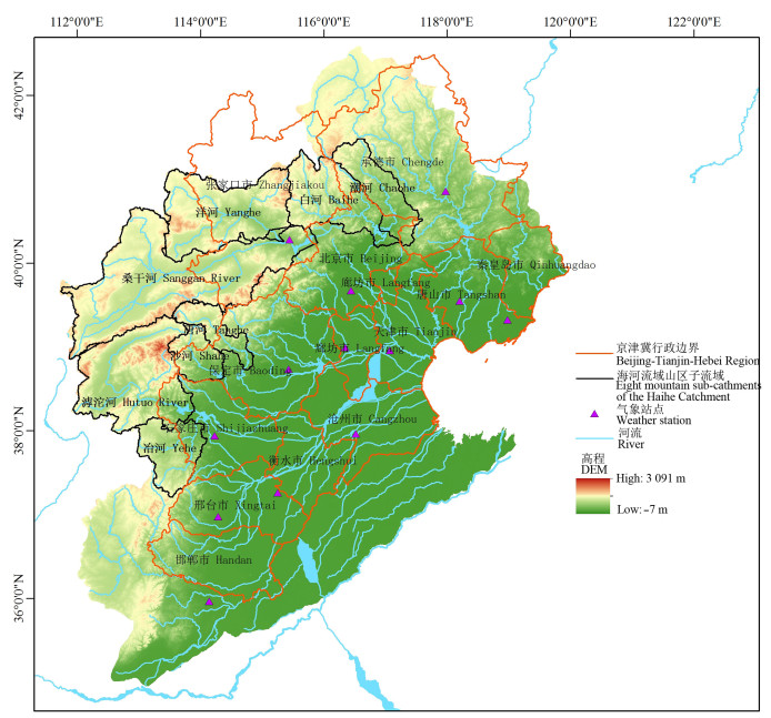
图1海河流域示意图
Figure1.Sketch map of the Haihe River Catchment
 下载: 全尺寸图片幻灯片
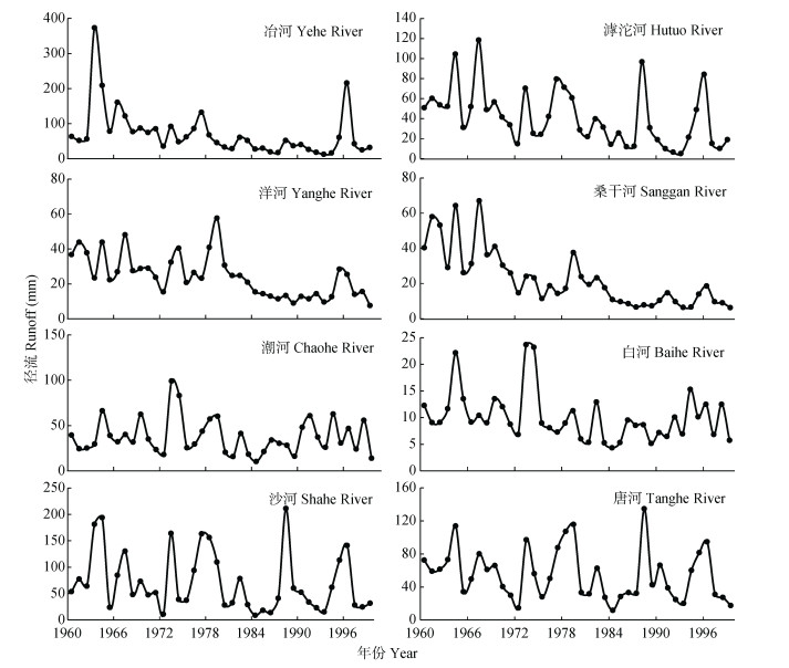
图2海河流域八大山区子流域年径流量变化(1960—1996年)[1]
Figure2.Annal runoff changes in eight mountain sub-cathments of the Haihe River Catchment from 1960 to 1996[1]
下载: 全尺寸图片幻灯片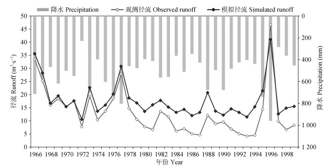
图3滹沱河上游绵河流域地都水文站观测径流与理论模拟径流对比[2]
Figure3.Comparsion of simulated runoff and measured runoff in Didu Hydrological Station of Mianhe in upstream of Hutuo River[2]
下载: 全尺寸图片幻灯片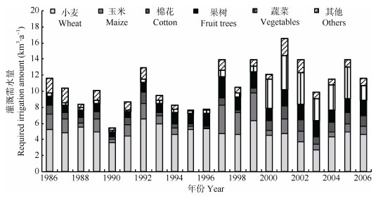
图41986—2006年河北平原地区不同作物灌溉需水量的时间变化趋势[3]
Figure4.Temperal changes of irrigation water requirments of different crops in the Hebei Plain from 1986 to 2006[3]
下载: 全尺寸图片幻灯片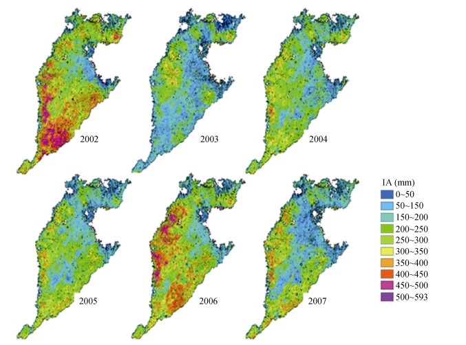
图52002—2007年海河平原农业灌溉用水(IA)的时空分布[4]
Figure5.Spatio-temporal distribution of agricultural irrigation water amount (IA) in the Haihe Plain from 2002 to 2007[4]
下载: 全尺寸图片幻灯片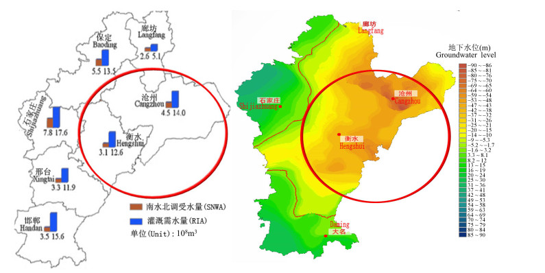
图6海河平原农业灌溉需水量的空间分布[4]
(a:南水北调各子区域受水量; b:地下水位空间分布。图中红圈标识区域为地下水漏斗严重区)
Figure6.Spatial distribution of requirement of agricultural irrigation (RIA) in the Haihe Plain[4]
(a: water intake of South-to-North Water Transfer (SNWT) in each sub-region; b: spatial distribution of groundwater level. Regions marked by red ring exist serious groundwater depression)
下载: 全尺寸图片幻灯片
图72011年京津冀地区土地-水资源-粮食平衡关系[6]
Figure7.Land, water and food balance in various cities in Beijing-Tianjin-Hebei Region in 2011[6]
P: production; C: consumption; Bvw: blue virtual water; Gvw: green virtual water; VW: total virtual water.
下载: 全尺寸图片幻灯片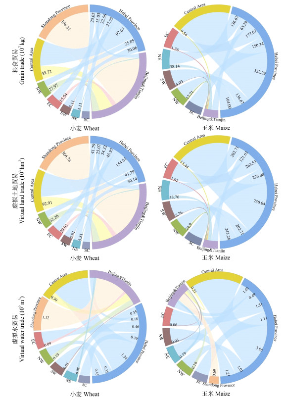
图8京津冀地区与全国其他地区的土地-水资源-粮食关联关系
外侧圆弧不同颜色代表不同地区; 中间贸易流颜色与外弧颜色相同代表向其他地区输出, 不同颜色代表输入; Central Area为中部地区(包括山西、河南、湖南、湖北、安徽和江西省), NW为西北地区(包括新疆、青海、甘肃、内蒙古、宁夏和陕西省), EC为东部沿海地区(包括江苏、上海和浙江省), SW为西南地区(包括四川、重庆、云南、贵州和广西省), NE为东北地区(包括黑龙江、吉林和辽宁省), SC为南部沿海地区(包括海南、广东和福建省)。
Figure8.Land-Water-Food NEXUS between Beijing-Tianjin-Hebei Region and other areas in China
Arcs with different color indicate different regions in China. Internal links mean transfers of grain/virtual water/virtual land transfer. Numbers are transfer quantities. Same color between arc and link means export to other regions, different colors means import. Central Area includes Shanxi, Henan, Hunan, Hubei, Anhui, and Jiangxi. NW (Northwest China) includes Xinjiang, Qinghai, Gansu, Inner Mongolia, Ningxia, and Shaanxi. EC (East Coast region) includes Jiangsu, Shanghai, and Zhejiang. SW (Southwest China) includes Sichuan, Chongqing, Yunnan, Guizhou and Guangxi. NE (Northeast China) includes Heilongjiang, Jilin, and Liaoning. SC (South Coast region) includes Hainan, Guangdong and Fujian.
下载: 全尺寸图片幻灯片表1海河流域八大山区子流域年径流下降的重要年份节点(基于Mann-Kendall检验结果)[1]
Table1.Important years of annual runoff changes in eight sub-cathments of the Haihe River Catchment from 1960 to 1996
| 子流域 Sub-catchment | 开始下降年份 Begin year of decline | 突变年份 Abrupt change year | 显著减少年份 Significant decline year |
| 冶河Yehe River | 1972 | 1978 | 1982 |
| 滹沱河Hutuo River | 1970 | 1979 | 1984 |
| 洋河Yanghe River | 1969 | 1979 | 1985 |
| 桑干河Sanggan River | 1968 | 1978 | 1974 |
| 潮河Chaohe River | 1970 | 1983 | No |
| 白河Baihe River | 1969 | 1980 | 1983 |
| 沙河Shahe River | 1970 | 1980 | No |
| 唐河Tanghe River | 1970 | 1980 | No |
下载: 导出CSV表2绵河流域模拟和观测年径流变化的统计分析
Table2.Change of annual runoff of Mianhe River in upstream of Hutuo River
| 年份 Year | 年降水 Annual precipitation (mm) | 年均径流量 Average annual runoff (m3·s-1) | 径流变化 Runoff change | ||||
| 观测 Measured | 模拟 Simulated | 时间范围 Time range | 观测 Measured (m3·s-1)/(%) | 模拟 Simulated (m3·s-1)/(%) | |||
| 1966—1970 | 574 | 21.67 | 20.08 | 1960s—1970s | -7.05/-32.51 | -1.26/-6.30 | |
| 1971—1980 | 534 | 14.63 | 18.82 | 1960s—1980s | -13.48/-62.17 | -3.46/-17.23 | |
| 1981—1990 | 509 | 8.19 | 16.62 | 1980s—1990s | 2.05/25.00 | 1.07/6.73 | |
| 1991—1999 | 514 | 10.24 | 17.55 | 1960s—1990s | -11.43/-52.75 | -2.53/-12.60 | |
下载: 导出CSV参考文献
| [1] | YANG Y H, TIAN F. Abrupt change of runoff and its major driving factors in Haihe River Catchment, China[J]. Journal of Hydrology, 2009, 374(3):373-383 |
| [2] | FAN J, TIAN F, YANG Y H, et al. Quantifying the magnitude of the impact of climate change and human activity on runoff decline in Mian River Basin, China[J]. Water Science & Technology, 2010, 62(4):783-791 |
| [3] | YANG Y M, YANG Y H, MOIWO J P, et al. Estimation of irrigation requirement for sustainable water resources reallocation in North China[J]. Agricultural Water Management, 2010, 97(11):1711-1721 doi: 10.1016/j.agwat.2010.06.002 |
| [4] | YANG Y M, YANG Y H, LIU D L, et al. Regional water balance based on remotely sensed evapotranspiration and irrigation:An assessment of the Haihe Plain, China[J]. Remote Sensing, 2014, 6(3):2514-2533 doi: 10.3390/rs6032514 |
| [5] | HU Y K, MOIWO J P, YANG Y H, et al. Agricultural water-saving and sustainable groundwater management in Shijiazhuang Irrigation District, North China Plain[J]. Journal of Hydrology, 2010, 393(3/4):219-232 |
| [6] | REN D, YANG Y H, YANG Y M, et al. Land-Water-Food Nexus and indications of crop adjustment for water shortage solution[J]. Science of The Total Environment, 2018, 626:11-21 doi: 10.1016/j.scitotenv.2018.01.071 |
| [7] | 杨永辉, 胡玉昆, 张喜英, 等.农业节水研究进展及未来发展战略[J], 中国科学院院刊, 2012, 27(4):455-461 doi: 10.3969/j.issn.1000-3045.2012.04.008 YANG Y H, HU Y K, Zhang X Y, et al. Agricultural water-saving:Recent progress and future challenges[J]. Bulletin of Chinese Academy of Sciences, 2012, 27(4):455-461 doi: 10.3969/j.issn.1000-3045.2012.04.008 |
| [8] | 刘晓燕, 刘昌明, 杨胜天, 等.基于遥感的黄土高原林草植被变化对河川径流的影响分析[J].地理学报, 2014, 69(11):1595-1603 doi: 10.11821/dlxb201411001 LIU X Y, LIU C M, YANG S T, et al. Influences of shrubs-herbs-arbor vegetation coverage on the runoff based on the remote sensing data in Loess Plateau[J]. Acta Geographica Sinica, 2014, 69(11):1595-1603 doi: 10.11821/dlxb201411001 |
| [9] | 杨春霄, 白洋淀入淀水量变化及影响因素分析[J].地下水, 2010, 32(02):110-112 doi: 10.3969/j.issn.1004-1184.2010.02.044 YANG C X. Analysis on the deposited quantity variation and its influenced factors in Baiyangdian[J]. Grondwater, 2010, 32(2):110-112 doi: 10.3969/j.issn.1004-1184.2010.02.044 |
